Cite this as: Adler-Wölfl, K. and Skomorowski, R. 2025 GIS Tools for Urban Archaeology in Vienna. Site Mapping with Different Geometries, Internet Archaeology 70. https://doi.org/10.11141/ia.70.10
Excavations in densely built city centres such as Vienna, Austria, clearly show the critical role of archaeological and historical research before digging starts. Geoinformation systems (GIS) can help process large and complex amounts of data and create accurate forecasts for construction projects.
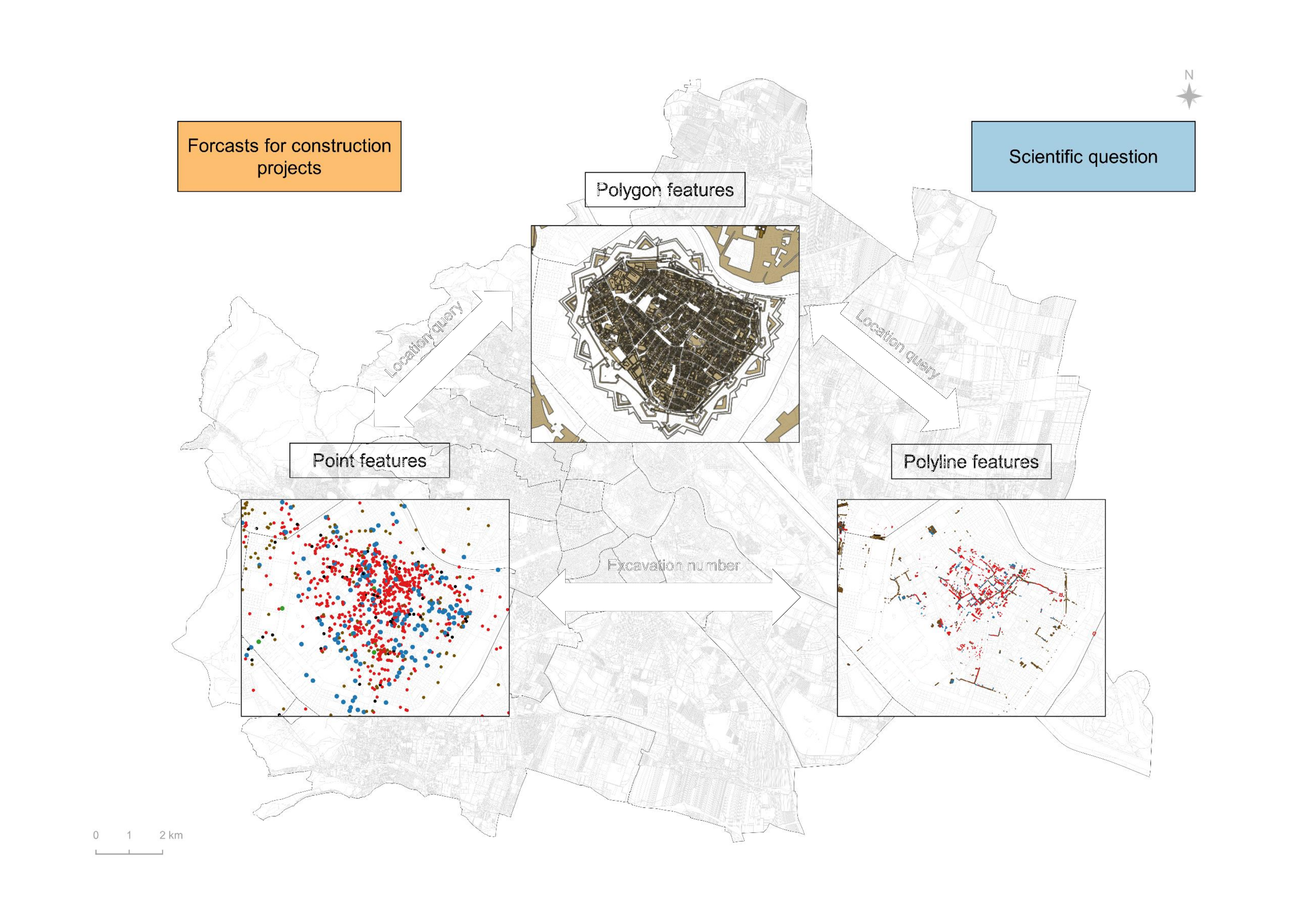
Vienna's urban archaeology has been using point-based GIS mapping of all known archaeological sites for a long time (Wien Kulturgut). However, to visualise the full extent of sites, extensive GIS mapping in the form of polygons is advantageous. The Vienna City Archaeology Department is currently collaborating with the Federal Monuments Office to implement this approach for Vienna. The impressive vector-based GIS mapping and historical landscape reconstructions compiled by Severin Hohensinner, based on several master theses at BOKU University Vienna, were used as the database for this.
The city of Vienna plans to transfer the current online service Wien Kulturgut to Masterportal. In this new geoportal, point-based GIS mapping, combined with excavation results in the form of polylines and polygon-based GIS mapping, will serve as a key tool for archaeological research and precise archaeological forecasts for construction projects, heritage management and public access.
Corresponding author: Kristina Adler-Wölfl
[email protected]
Museen der Stadt Wien-Stadtarchäologie
Roman Skomorowski
[email protected]
Museen der Stadt Wien-Stadtarchäologie
Figure 1: Point-based GIS mapping of archaeological sites in the Wien Kulturgut internet portal (© Stadt Wien, Wien Kulturgut).
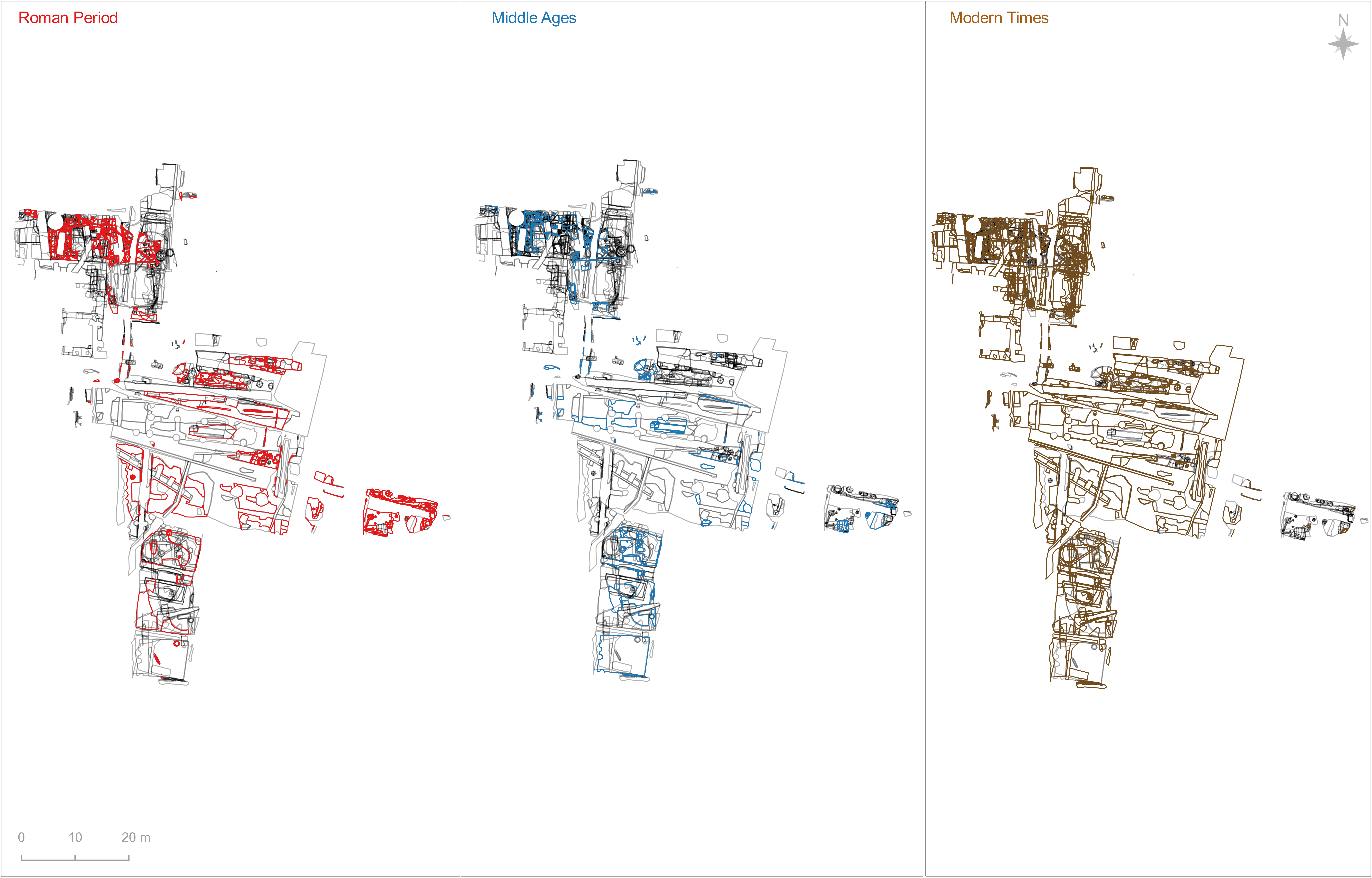
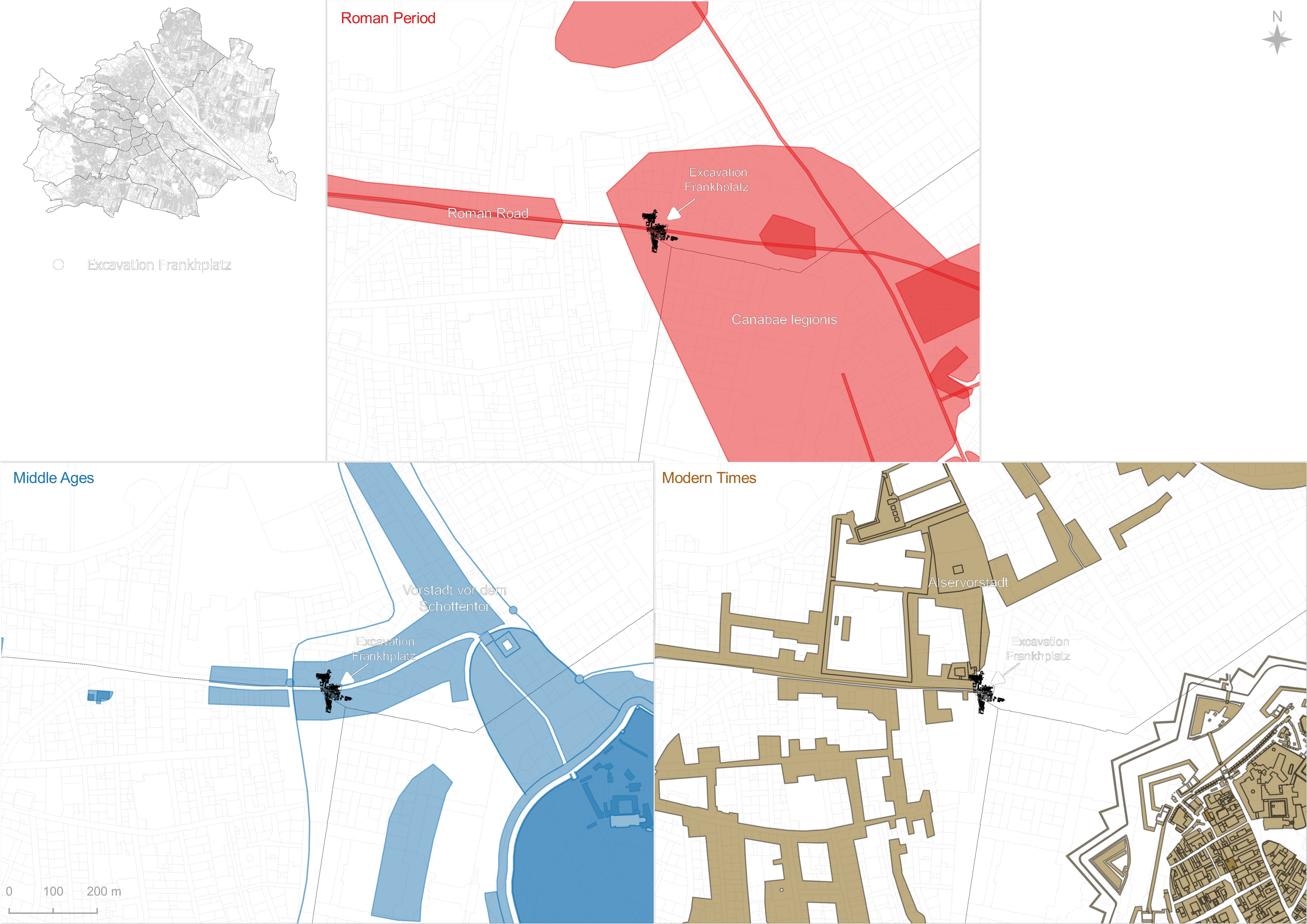
Figure 2: Excavation results for Frankhplatz and the classification of polylines according to their period (© Stadtarchäologie Wien).
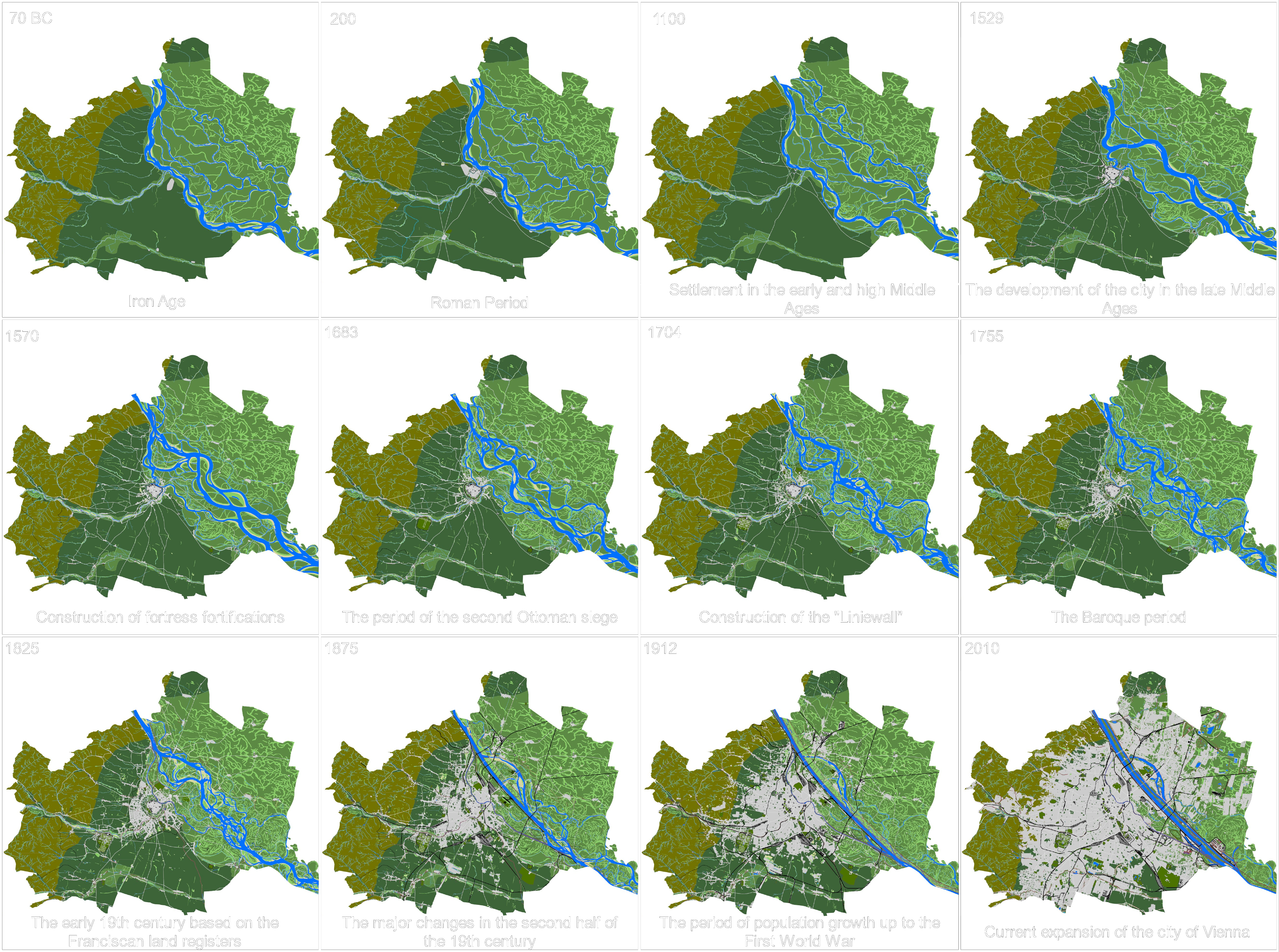
Figure 3: Vector-based GIS mappings and historical landscape reconstructions (© Severin Hohensinner et al. (BOKU University Vienna) and Wien Museum).
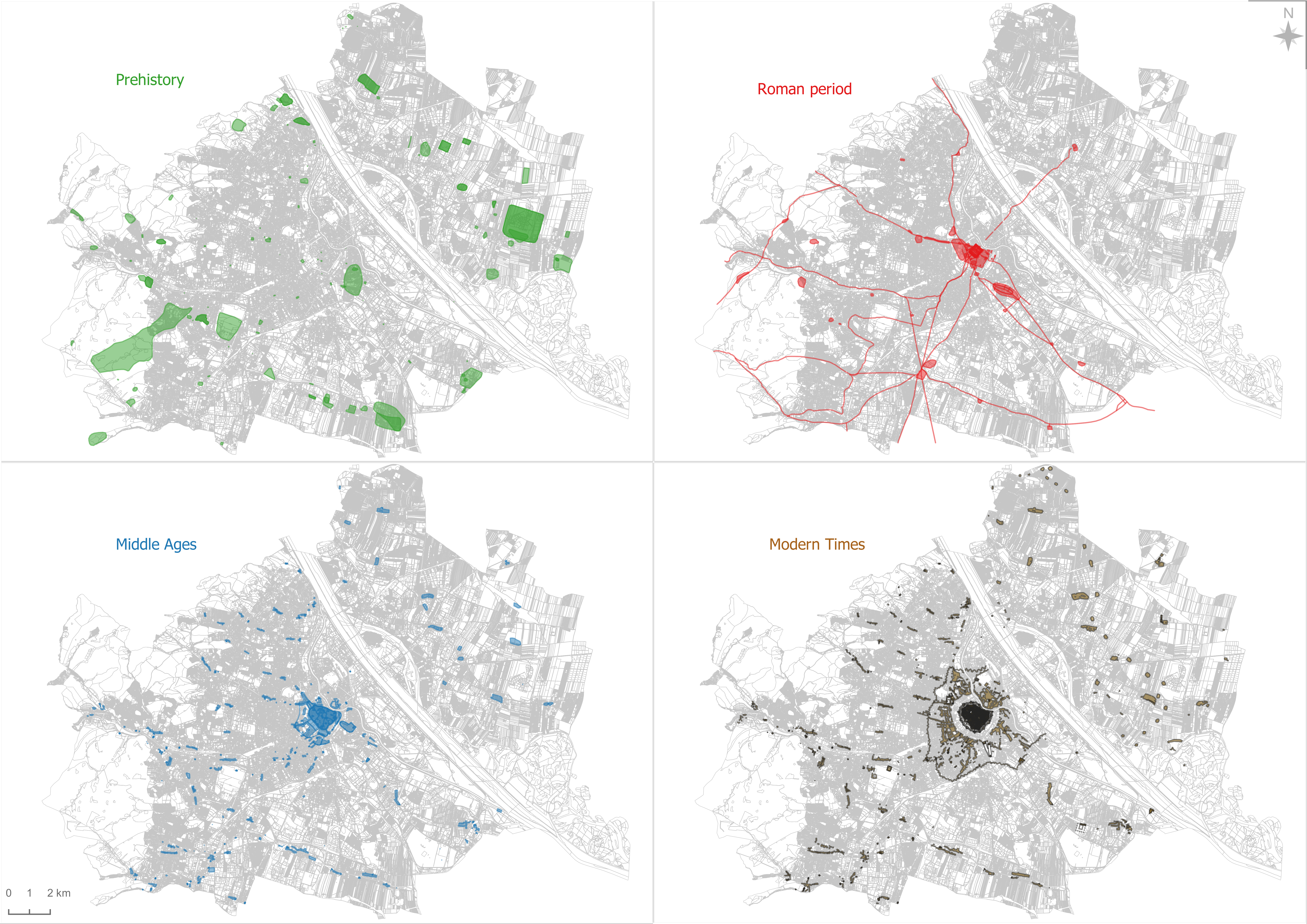
Figure 4: Polygon-based GIS mapping from prehistory to modern times (© Severin Hohensinner et. al. (BOKU University Vienna), Wien Museum and Stadtarchäologie Wien).
Figure 5: The polygon features are linked to the point features and polyline features via a location query (© Stadtarchäologie Wien).
Figure 6: The location of features from the Frankhplatz excavation, from the Roman period to modern times (© Stadtarchäologie Wien).
Börner, W. and Öllerer, C. 1998 'Der "Archäologische Kataster" im Rahmen des Schutzzonenprojekts der Stadt Wien', Fundort Wien, Berichte zur Archäologie 1, 64–66. https://stadtarchaeologie.at/start/publikationen/fundort-wien/fundort-wien-1/
Börner, W., Saul, R. and Scheuchel, P. 2008 'Web-Portal "Wien Kulturgut" - Der neue Kulturgüterkataster der Stadt Wien', Fundort Wien, Berichte zur Archäologie 11, 322–325. https://stadtarchaeologie.at/start/publikationen/fundort-wien/fundort-wien-11/
Liebert, L. and Mosser, M. 2005 'Zum archäologischen Informationsservice der Stadtarchäologie Wien', Fundort Wien, Berichte zur Archäologie 8, 4–15. https://stadtarchaeologie.at/start/publikationen/fundort-wien/fundort-wien-8/
Mosser, M. 1998 'Das Legionslager Vindobona - EDV-gestützte Erfassung alter und neuer Grabungen', Fundort Wien, Berichte zur Archäologie 1, 74–88. https://stadtarchaeologie.at/start/publikationen/fundort-wien/fundort-wien-1/
Mosser, M. and Krause, H. 2012 'Ein "archäologisches Frühwarnsystem" für das Bauwesen - das Wiener Bastionen-GIS', Fundort Wien, Berichte zur Archäologie 15, 4–32. https://stadtarchaeologie.at/start/publikationen/fundort-wien/fundort-wien-15/
Internet Archaeology is an open access journal based in the Department of Archaeology, University of York. Except where otherwise noted, content from this work may be used under the terms of the Creative Commons Attribution 3.0 (CC BY) Unported licence, which permits unrestricted use, distribution, and reproduction in any medium, provided that attribution to the author(s), the title of the work, the Internet Archaeology journal and the relevant URL/DOI are given.
Terms and Conditions | Legal Statements | Privacy Policy | Cookies Policy | Citing Internet Archaeology
Internet Archaeology content is preserved for the long term with the Archaeology Data Service (ROR). Help sustain and support open access publication by donating to our Open Access Archaeology Fund.
 Home
Home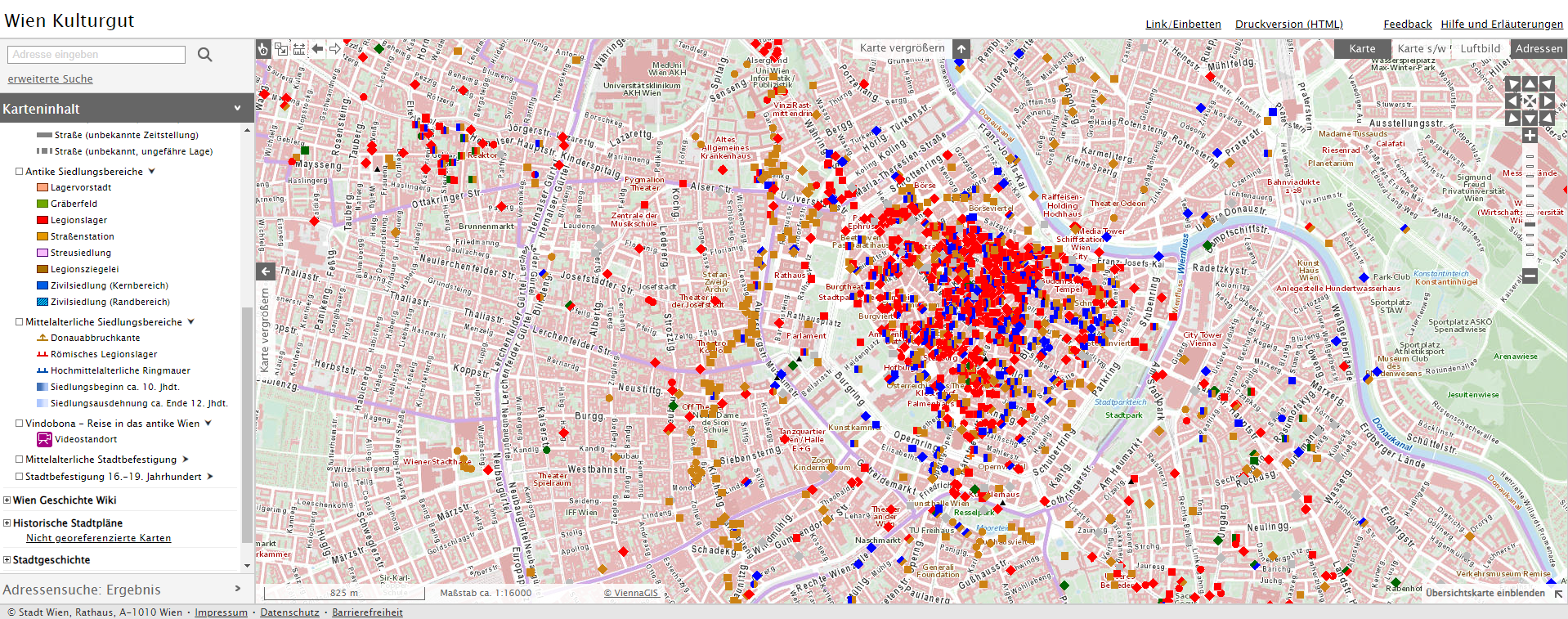