Cite this as: Bryant, S. and Dupuis, M. 2025 Archaeology in the Changing Townscape: The Centre Region in France, Internet Archaeology 70. https://doi.org/10.11141/ia.70.12
After a period of urban development in historic town centres between the 1970s and the 1980s, which resulted in the destruction of many archaeological sites, archaeology has gone from being perceived and experienced as a purely unwanted obligation, to being an integral part of town planning and development.
A growing awareness of the environmental and social challenges posed by urban sprawl, vehicle traffic and climate change has started to modify our vision of the town and how it should be developed. One consequence has been a marked increase in the density of urban fabric and the renewal of old town centres, encouraged by government projects designed to improve their appeal. This paper aims to retrace this evolution through the example of the Centre region of France, paying particular attention to Chartres. Through the respective and complementary actions of the state authorities (Ministry of Culture) and the archaeology services belonging to local government authorities (departments and municipalities), this study illustrates the role of archaeology in the urban environment as a means of action for local decision makers, and as a factor that can add high cultural value to local areas through building and strengthening local identities and promoting a scientific and heritage culture.
Corresponding author: Simon Bryant
[email protected]
Chartres Métropole and Orléans, Service Régional de l'Archéologie
Mathias Dupuis
[email protected]
Chartres Métropole archaeological service
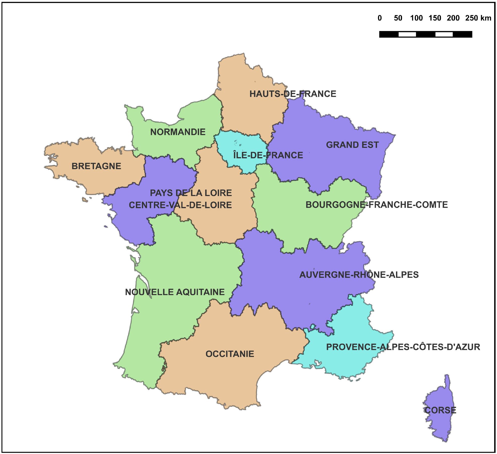
Figure 1: Maps of the metropolitan regions of France (a) before and (b) after the 'Notre' reform of 2016.
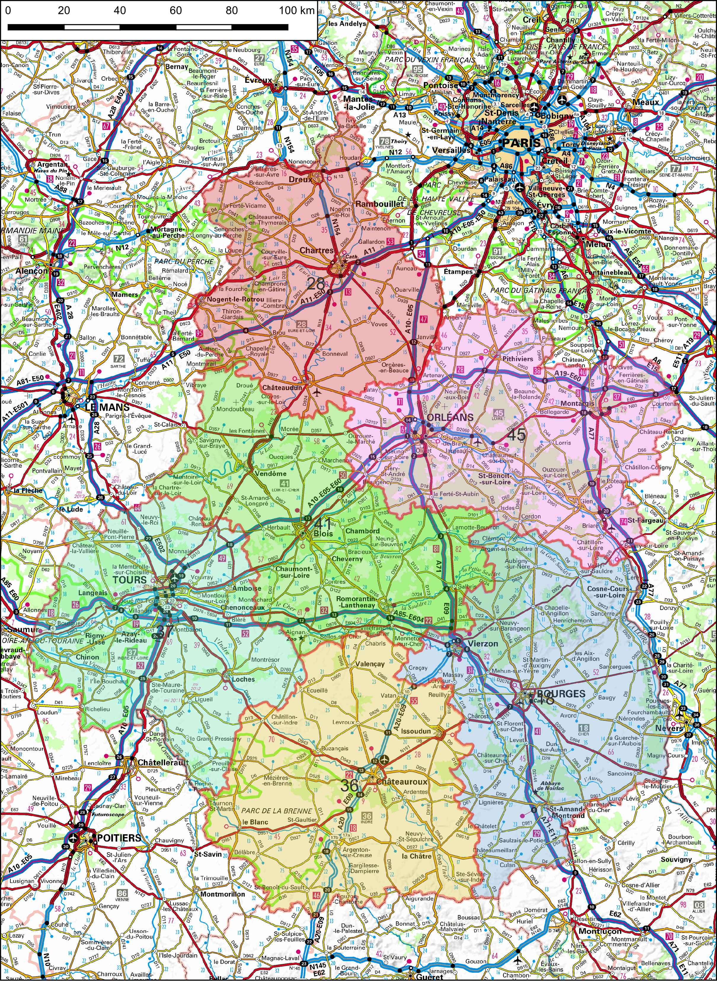
Figure 2: A map of the Centre–Val-de-Loire region, with six departments.
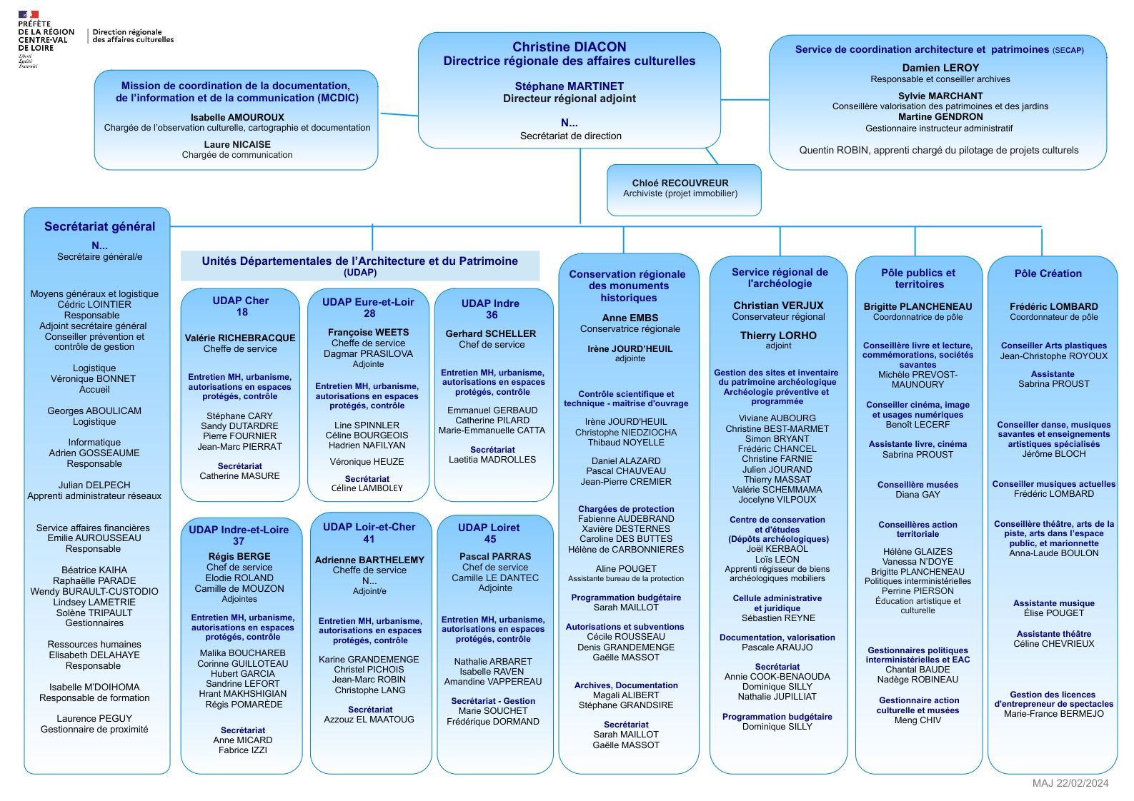
Figure 3: The organisation of the Direction Régionale des Affaires Culturelles (DRAC) of the Centre–Val-de-Loire region in France, January 2024 (diagram Ministère de la Culture).
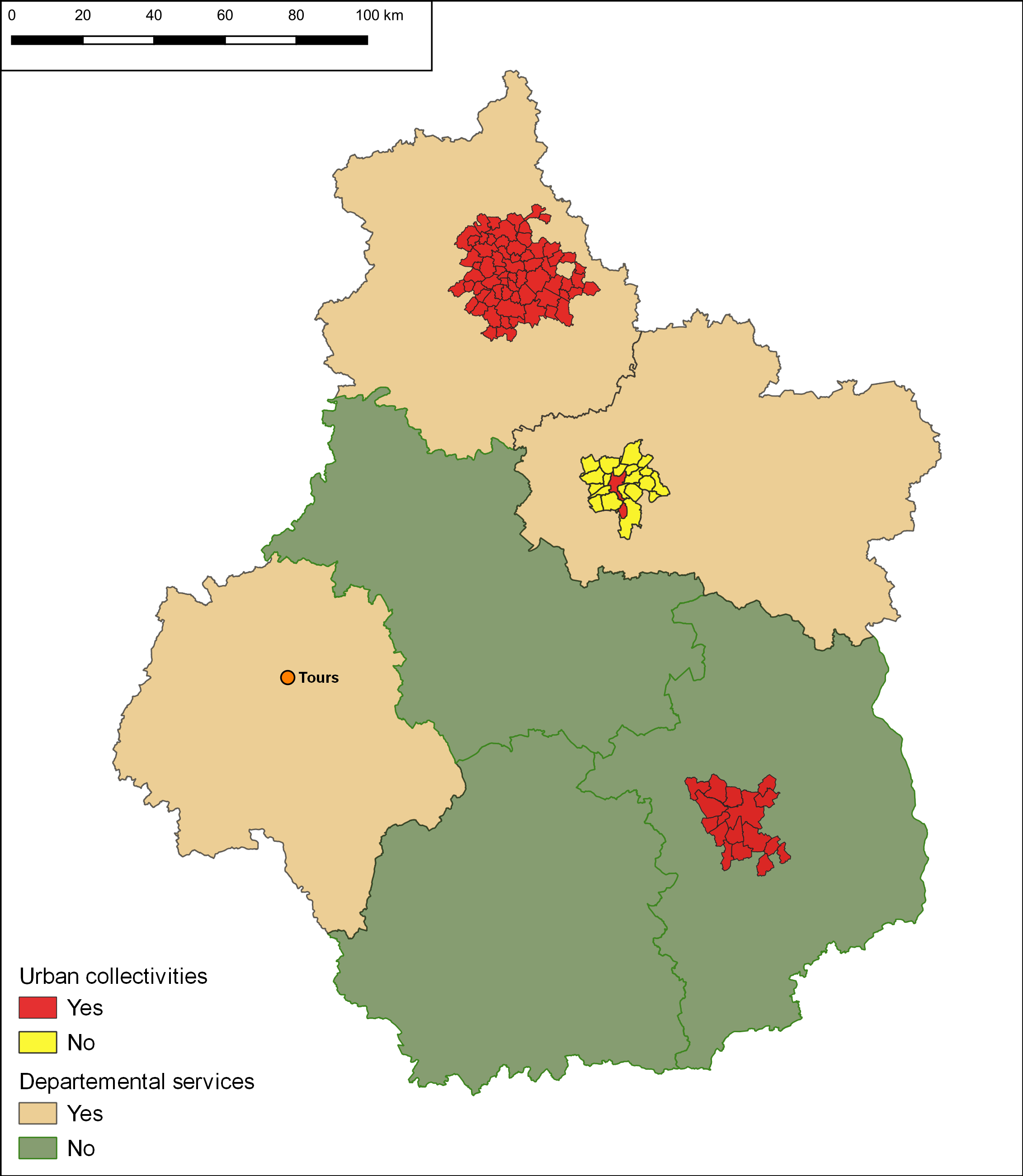
Figure 4: A map of the Centre–Val-de-Loire region showing the regional archaeology units.
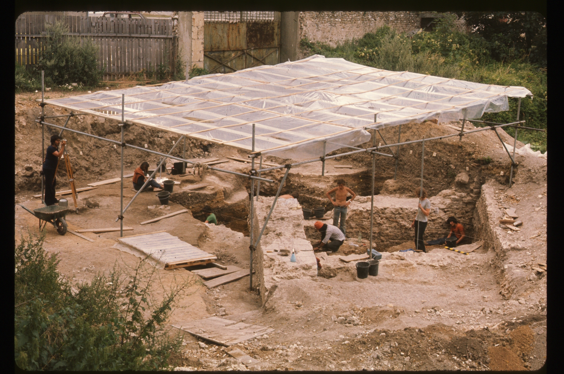
Figure 5: The research excavation rue Sainte-Thérèse at Chartres, directed by Pierre Courbin as a training dig from 1967 to 1972, following the excavation and recording methods of Sir Mortimer Wheeler (image Direction de l'Archéologie de Chartres Métropole).
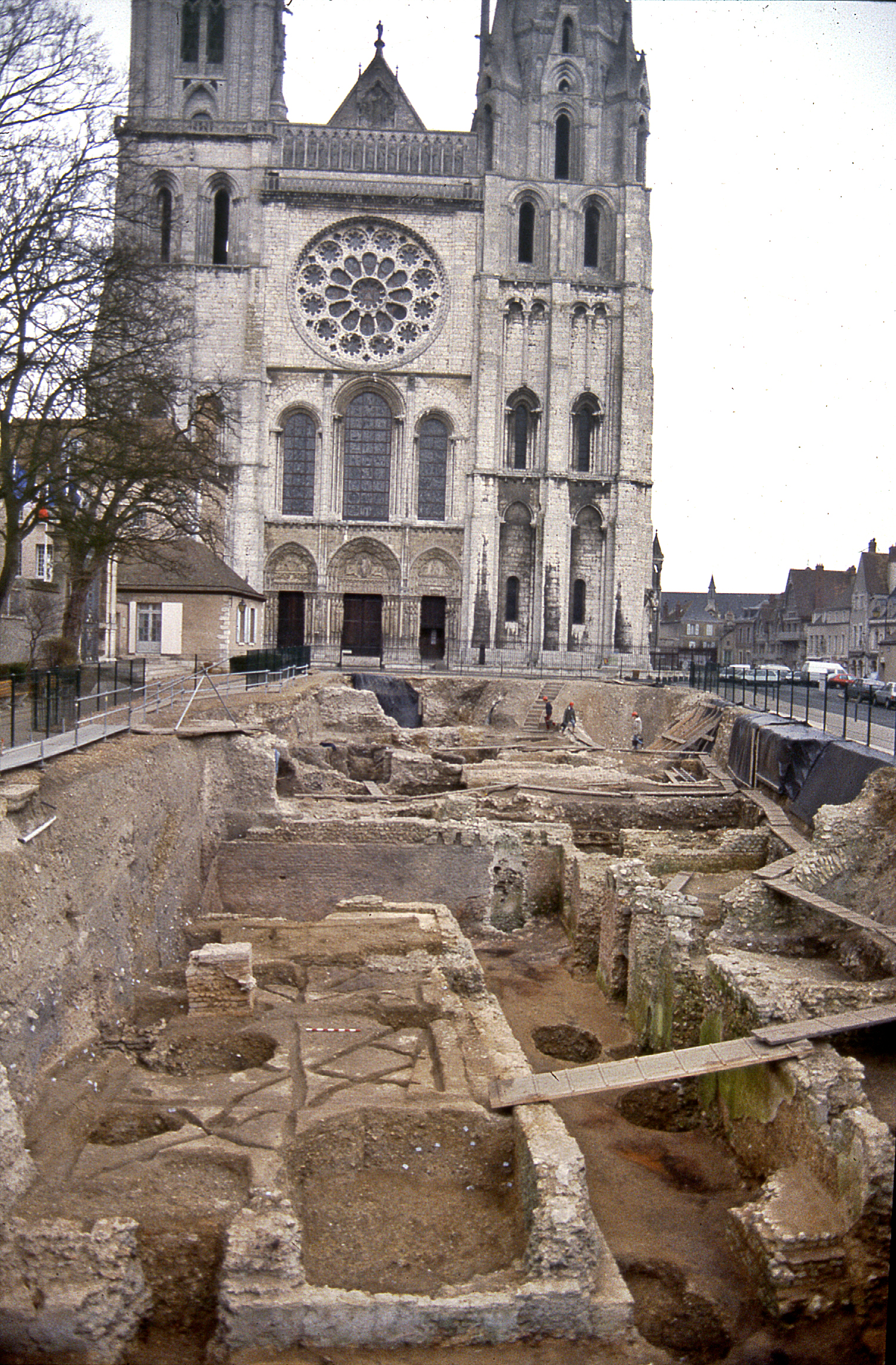
Figure 6: Excavation of the western square of Chartres cathedral, 1990–1992. Initially carried out in advance of a projected visitors' centre, the development project was abandoned before being renewed in 2021 (image Bernard Randoin, DRAC Centre–Val-de-Loire).
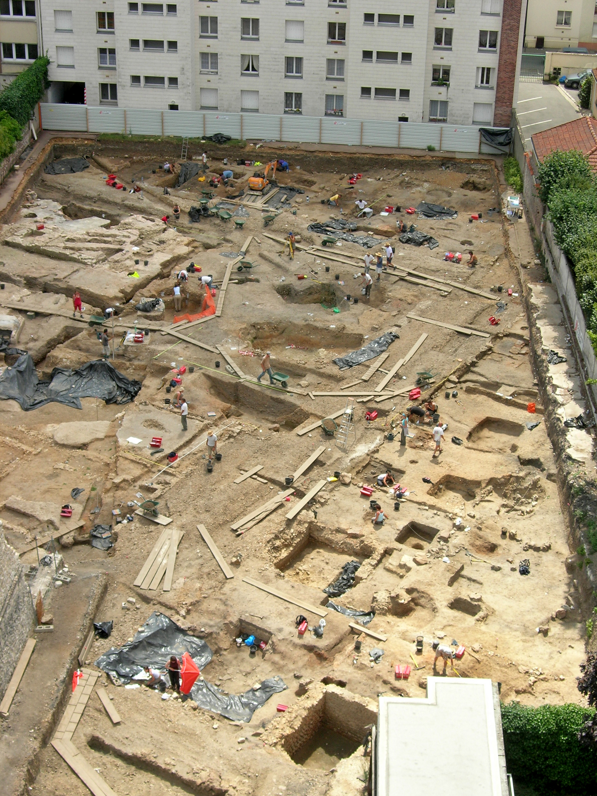
Figure 7: A change of scale. Excavation of the 'Cinema' site in Chartres in 2005. This was the first totally 'in-house' rescue excavation carried out by the municipal archaeology service under the direction of Dominique Joly (image Direction de l'Archéologie de Chartres Métropole).
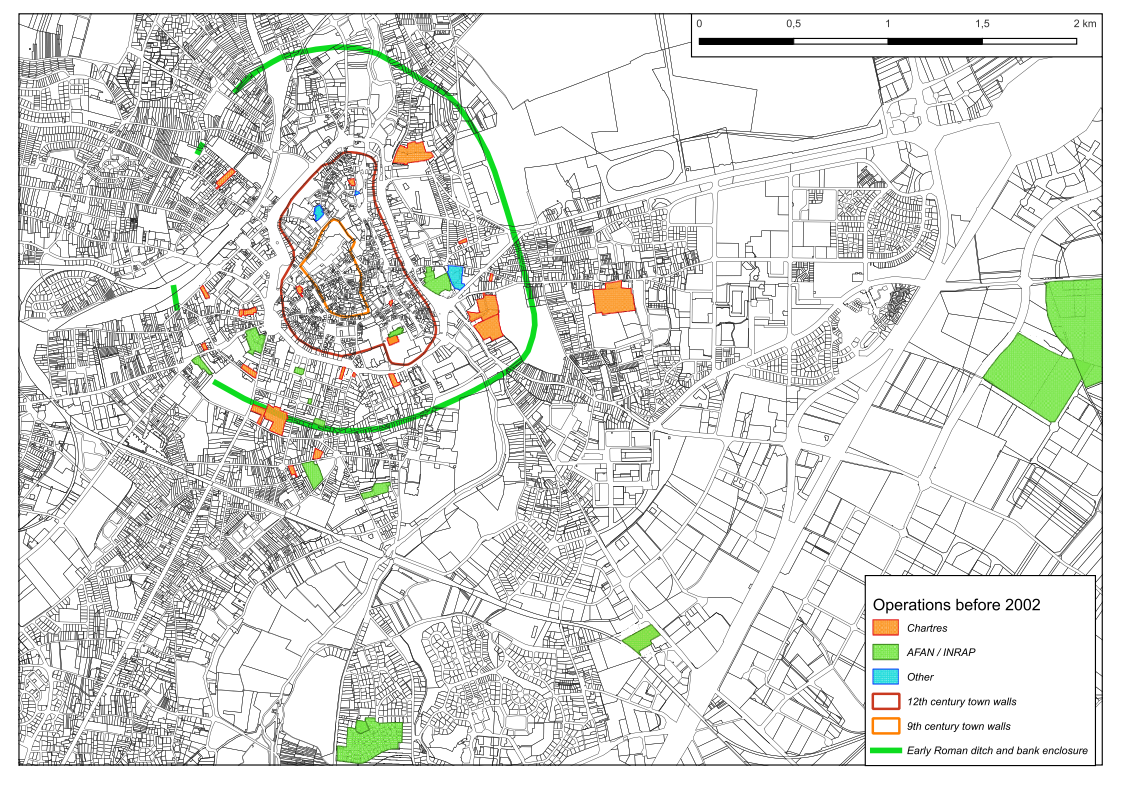
Figure 8: A map of the archaeological excavations carried out around Chartres before 2002, sorted by operator. The many excavations in the historic centre, all carried out by the municipal archaeology service, have been left out for clarity.
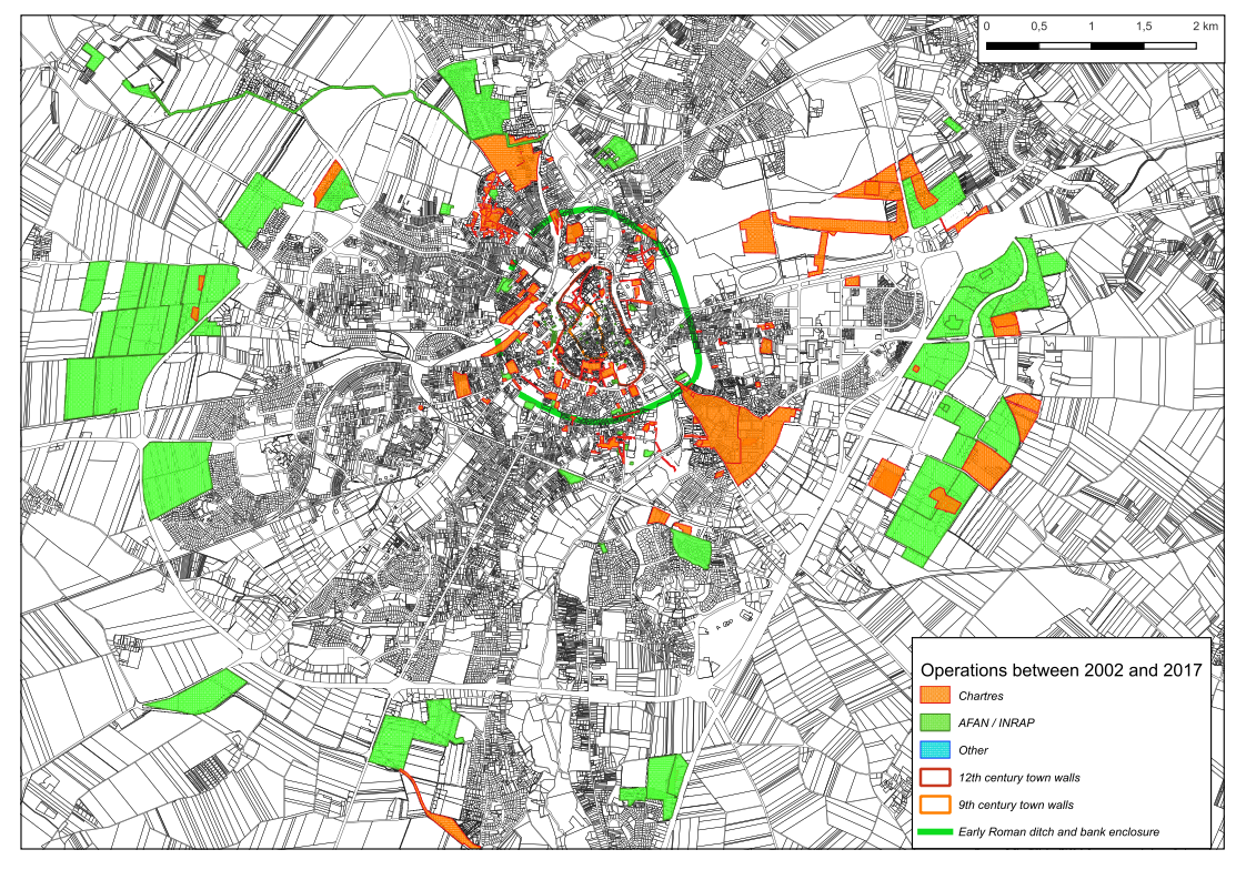
Figure 9: A map of the archaeological excavations carried out around Chartres between 2003 and 2017, sorted by operator.
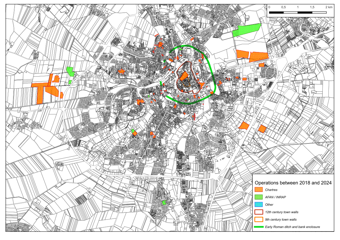
Figure 10: A map of the archaeological excavations carried out around Chartres between 2018 and 2023, sorted by operator.
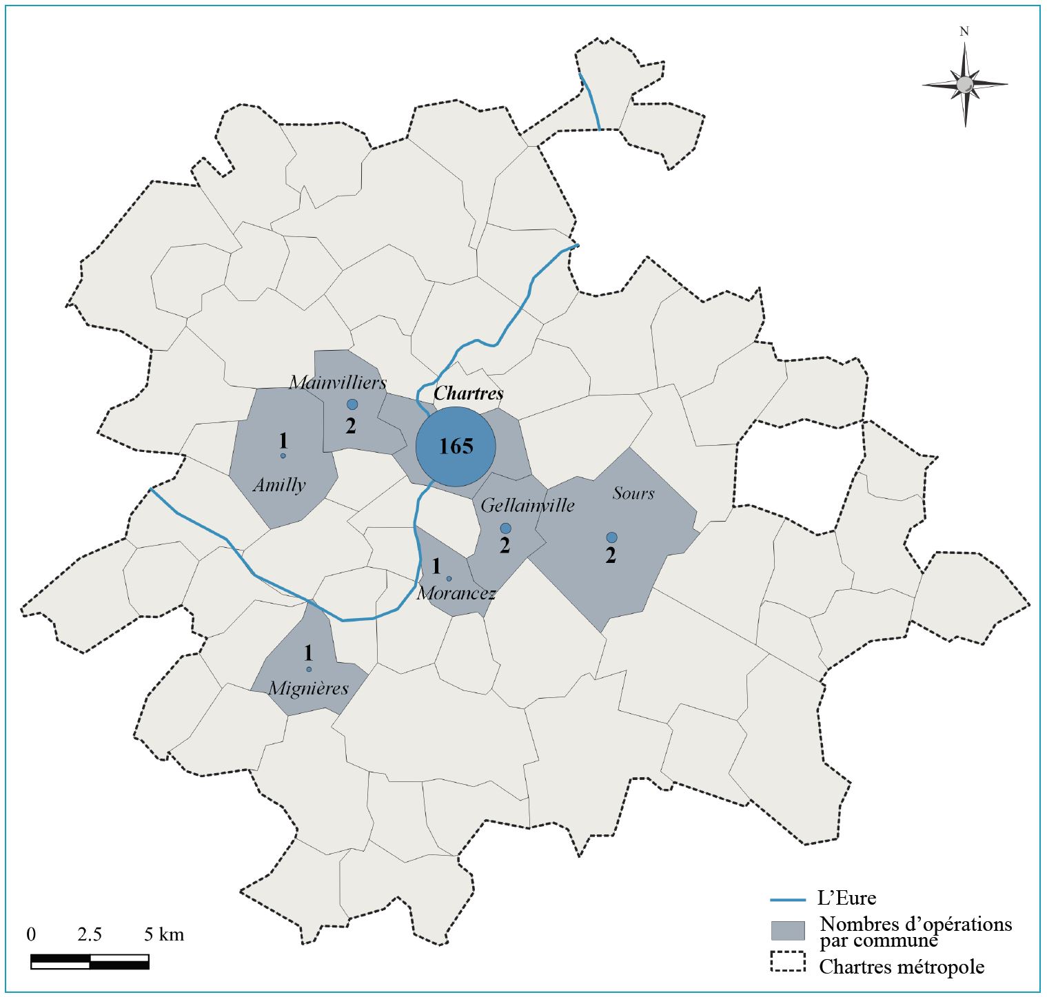
Figure 11: Archaeological excavations carried out in the 66 communes of the urban community of Chartres by their respective archaeology units between 2003 and 2018, by number of operations. The commune of Chartres with the city centre represents the overwhelming majority of the excavations (cartography Direction de l'Archéologie de Chartres Métropole).
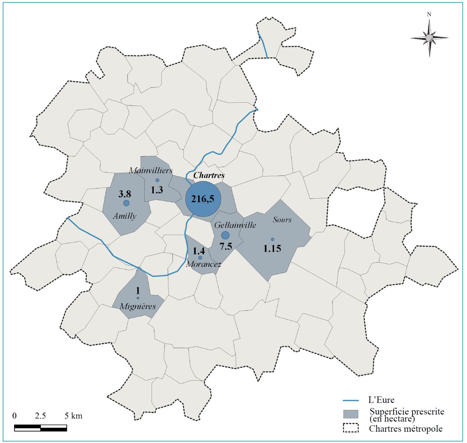
Figure 12: Archaeological excavations carried out in the 66 communes of the urban community of Chartres by their respective archaeology units between 2003 and 2018, in terms of surface area (cartography Direction de l'Archéologie de Chartres Métropole).
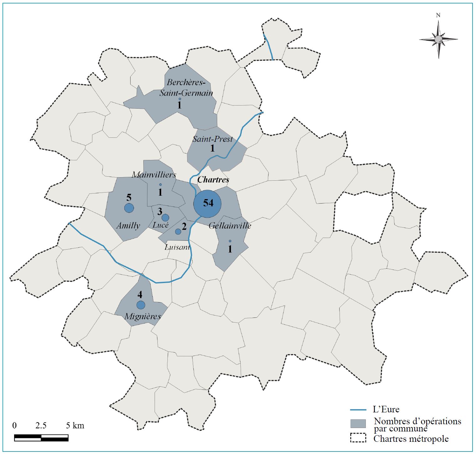
Figure 13: Archaeological excavations carried out in the 66 communes of the urban community of Chartres by their respective archaeology units between 2018 and 2023, by number of operations. The activity in the centre of the town has diminished to about a third of that of the previous period (cartography Direction de l'Archéologie de Chartres Métropole).
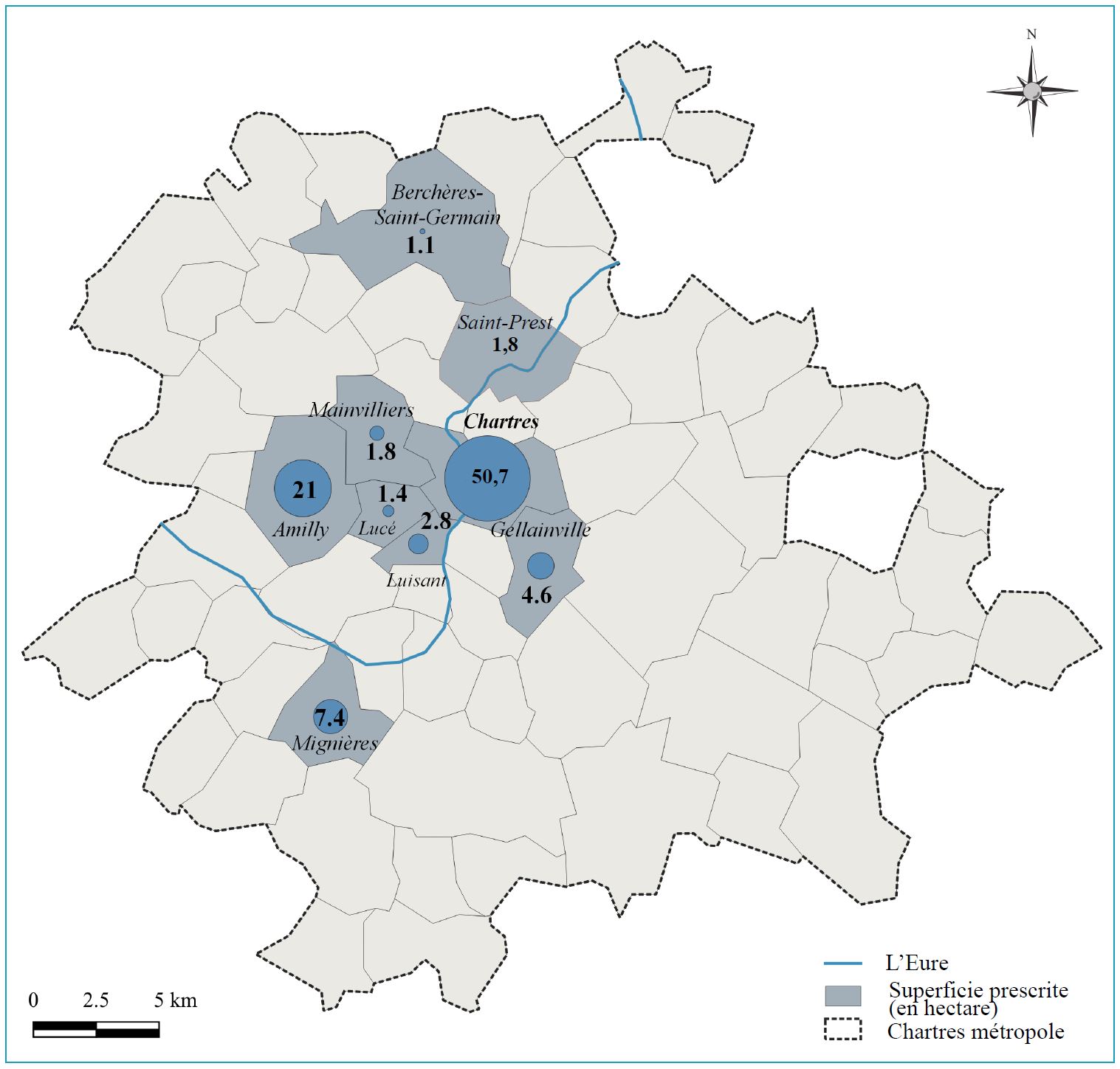
Figure 14: Archaeological excavations carried out in the 66 communes of the urban community of Chartres by their respective archaeology units between 2018 and 2023, by number of operations. The activity in the centre of the town has diminished to about a quarter of that of the previous period, with a shift towards the communes to the west (cartography Direction de l'Archéologie de Chartres Métropole).
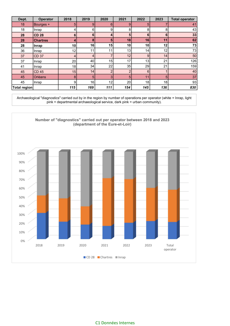
Figure 15: A summary of the number of archaeological evaluations (diagnostic) carried out by the public operators in the Centre–Val-de-Loire region between 2018 and 2023. The graph represents the proportion of these operations taken on by the regional units and the national operator in the department of the Eure-et-Loir (data SRA, DRAC Centre Val-de-Loire).
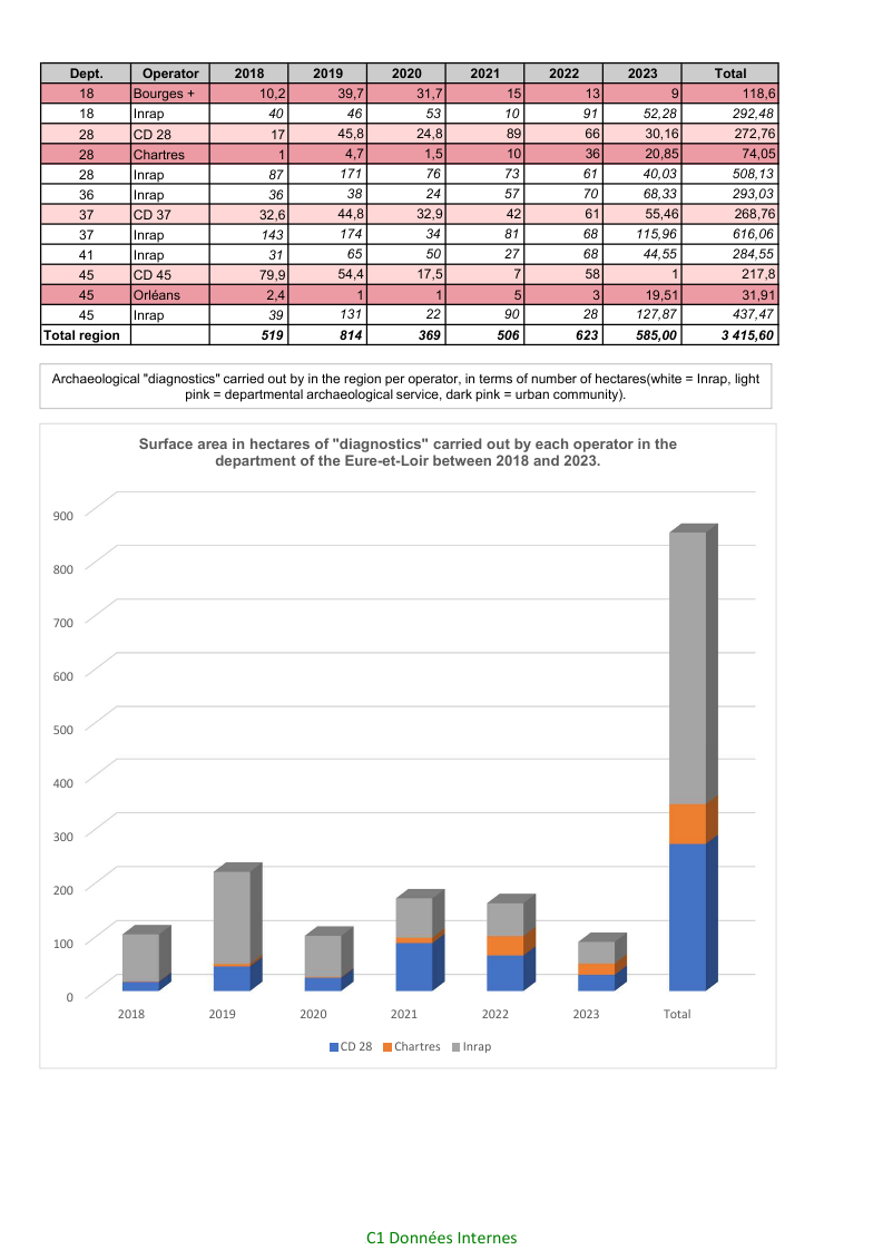
Figure 16: A summary of the surface area in hectares of the archaeological evaluations (diagnostic) carried out by the public operators in the Centre–Val-de-Loire region between 2018 and 2023. The graph represents the proportion of these operations taken on by the regional units and the national operator (data SRA, DRAC Centre Val-de-Loire).
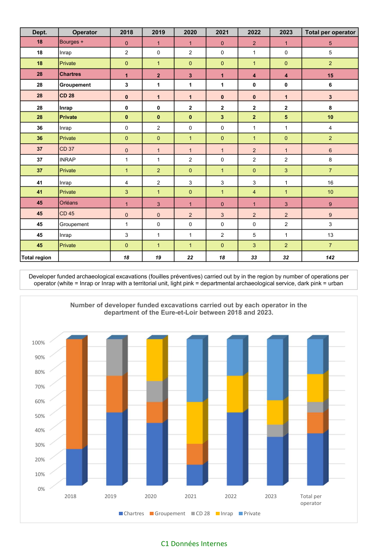
Figure 17: A summary of the number of developer-funded rescue excavations (fouilles préventives) carried out by all operators in the Centre–Val-de-Loire region between 2018 and 2023. The graph represents the proportion of these operations in the department of the Eure-et-Loir (data SRA, DRAC Centre Val-de-Loire).
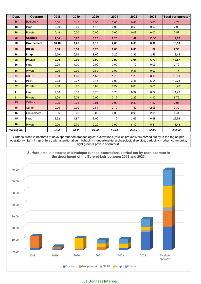
Figure 18: A summary of the surface area in hectares of the archaeological evaluations (diagnostic) carried out by the public operators in the Centre–Val-de-Loire region between 2018 and 2023. The graph represents the proportion of these operations taken on by the regional units and the national operator (data SRA, DRAC Centre Val-de-Loire).
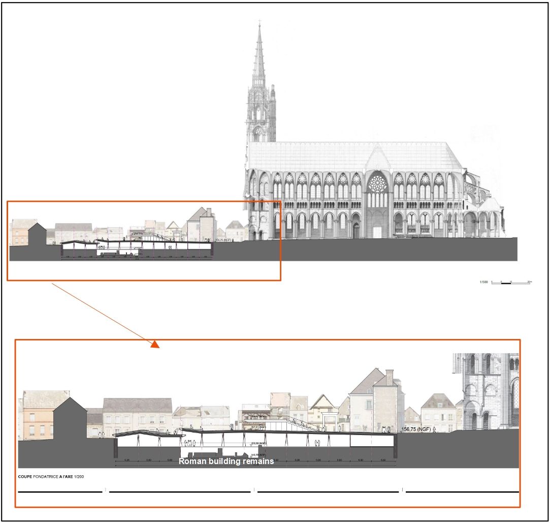
Figure 19: A section of the planned visitor centre in the western cathedral square. The centre will integrate the masonry remains of the Roman period buildings discovered during the excavations at Chartres in 1992, and will necessitate further excavation of the northern part of the cathedral square. The scientific content will draw on the results of historical and archaeological research carried out in the cathedral square since the 19th century (image taken from the pre-project presentation by Forma6 architects and ARCADIS civil engineering).
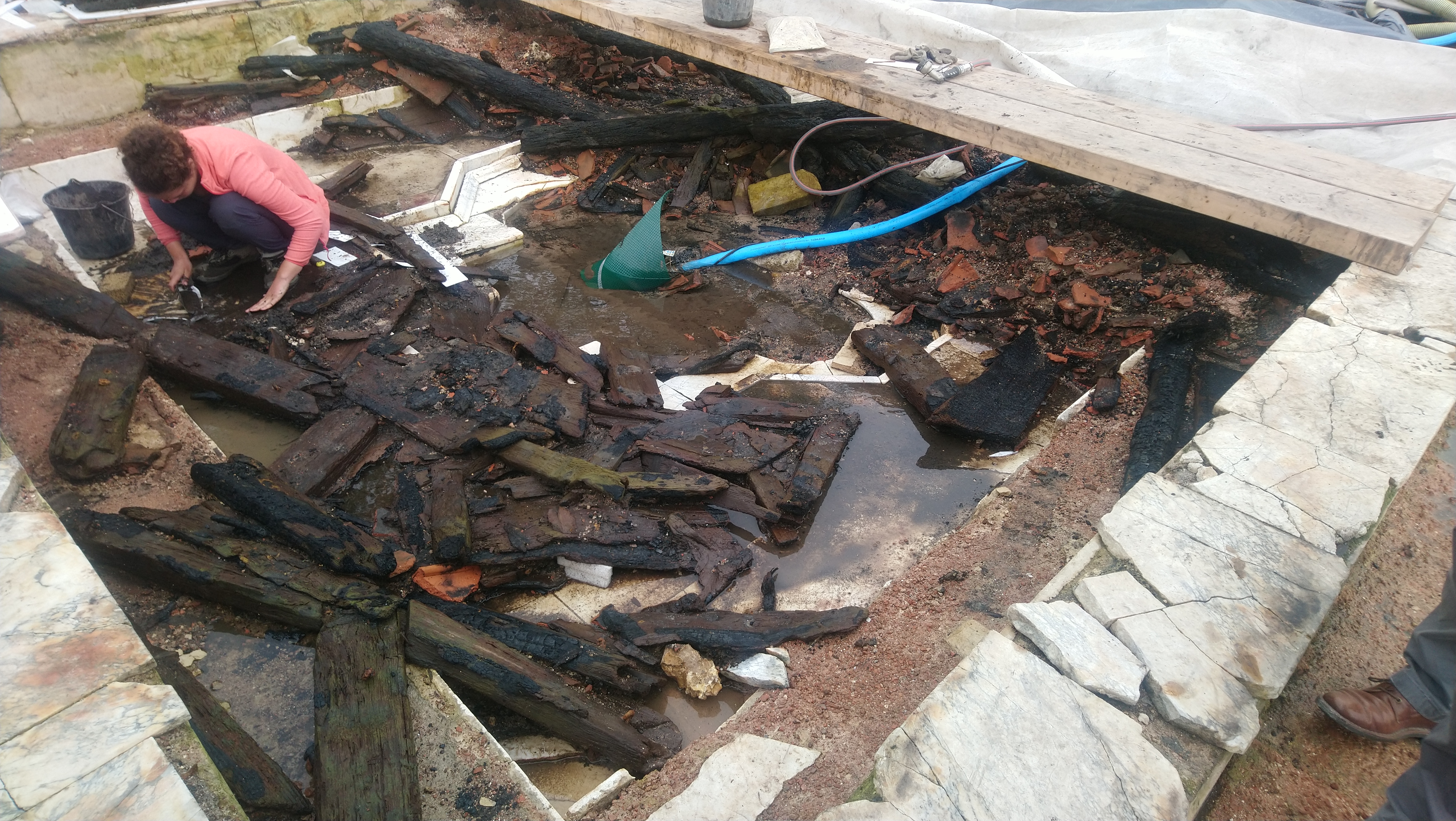
Figure 20: The excavation of the Roman period temple complex at Saint-Martin-au-Val, Chartres, in 2022. With the water table close to the surface, the partially carbonised remains of a Roman wooden coffered ceiling were perfectly preserved. The research excavation of this exceptional site allowed the development of excavation and recording methods that can be applied to similar deposits (image Direction de l'Archéologie de Chartres Métropole).
Borderie, Q., Delahaye, J., Desacy, B., Gravier, J. and Pinhede, A. 2013 'Les synthèses archéologiques urbaines, un projet en cours' in E. Lorans and X. Rodier (eds) Archéologie de l'espace urbain, Tours: Presses universitaires François-Rabelais. 263–76. https://doi.org/10.4000/books.pufr.7678
Chaillou, A. and Thomas, J. 2007 'L'application Patriarche. Inventaire informatique de la carte archéologique nationale', Les Nouvelles de l'Archéologie 107, 52–7. https://doi.org/10.4000/nda.498
Demolon, P., Louis, E. and Louis-Vanbauce, M. 1990 Douai : document d'évaluation du patrimoine archéologique urbain, Paris: Association pour les Fouilles Archéologiques Nationales/Centre National d'Archéologie Urbaine (CNAU)/Ministère de la Culture.
Fromentin, F., Lauzanne, S. and Ropars, A. 2006 'L'inventaire archéologique national' in M. Dabas, H. Delétang, A. Ferdière and C. Jung (eds) La prospection, Paris: Errance. 8–12.
Garmy, P. 2016 'Tombeau du Centre national d'archéologie urbaine (Cnau)', Les Nouvelles de l'Archéologie 146, 60–1. https://doi.org/10.4000/nda.3849
Joly, D. 2013 'De la fouille urbaine à l'archéologie de la ville: le cas de Chartres' in E. Lorans and X. Rodier (eds) Archéologie de l'espace urbain, Tours: Presses universitaires François-Rabelais. 37–49. https://doi.org/10.4000/books.pufr.7628
Internet Archaeology is an open access journal based in the Department of Archaeology, University of York. Except where otherwise noted, content from this work may be used under the terms of the Creative Commons Attribution 3.0 (CC BY) Unported licence, which permits unrestricted use, distribution, and reproduction in any medium, provided that attribution to the author(s), the title of the work, the Internet Archaeology journal and the relevant URL/DOI are given.
Terms and Conditions | Legal Statements | Privacy Policy | Cookies Policy | Citing Internet Archaeology
Internet Archaeology content is preserved for the long term with the Archaeology Data Service (ROR). Help sustain and support open access publication by donating to our Open Access Archaeology Fund.
 Home
Home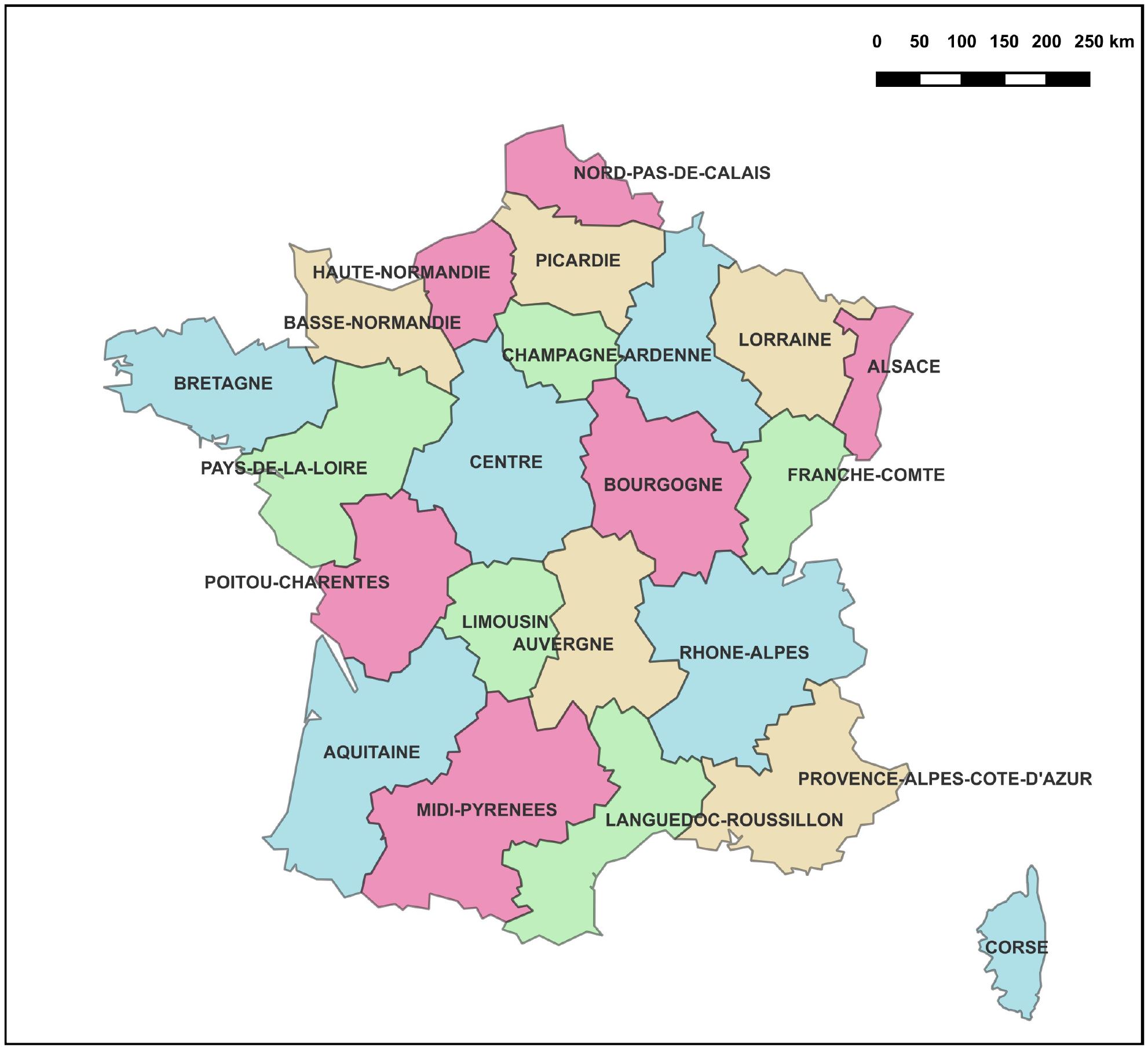