Cite this as: Novák, D., Staňková, V., Rýpar, V., Podliska, J. and Hasil, J. 2025 Managing the Urban Archaeological Heritage of Prague: The Benefits of Collaboration, Internet Archaeology 70. https://doi.org/10.11141/ia.70.3
The field of urban archaeology is confronted by a number of challenges that are not typically encountered by archaeologists working in non-urbanised areas. The concentration of archaeological sites, often accumulated over hundreds of years, gives rise to the formation of highly complex archaeological landscapes. Conducting research in such complicated situations requires not only individual expertise, but also the establishment of a support system and knowledge base that enables experts to use information from previous fieldwork effectively. Undertaking research in completely unknown terrain is considerably more challenging than being equipped with knowledge and a comprehensive account of excavations previously carried out in an area.
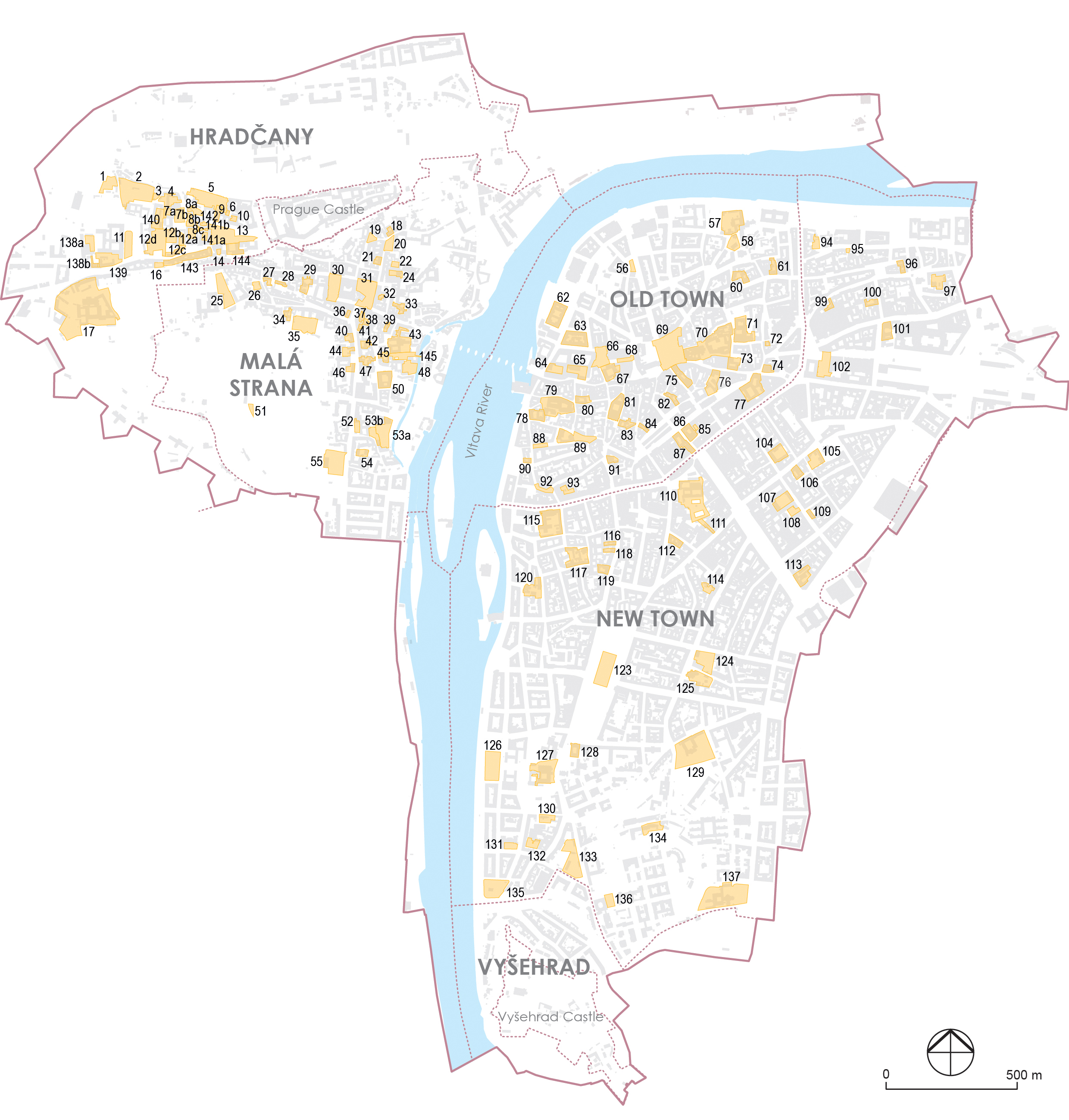
The city of Prague represents one of the longest continuous settlements in Europe, with development dating back to the 9th century (Havrda 2021). This correlates with the volume and complexity of the local archaeological remains. The Prague Heritage Reserve (Figures 1 and 2), which encompasses an area of 8.66 km², is one of the most extensive protected sites in the Czech Republic and is among the largest in the world. The site has been included on the United Nations Educational, Scientific and Cultural Organization (UNESCO) World Heritage List since 1992, designated as the Historic Centre of Prague. The area in question constitutes 1.74% of the total area of the city. The site's exceptional value lies not only in the number of unique buildings scattered throughout the agglomeration, but also in the volume of undisturbed archaeological terrain and monuments hidden beneath the current surface. These constitute an irreplaceable historical resource, not in themselves, but in the context of the remaining finds.
The Prague archaeological community was quick to recognise the necessity of adopting a systematic approach to research, and the importance of creating sufficiently rich sources of information. Two institutions were pivotal in this process: the Institute of Archaeology of the Academy of Sciences of the Czech Republic in Prague (IAP-CAS), and the Prague office of the National Heritage Institute (NHI). Both institutions have developed their own conceptual frameworks for managing Prague's archaeological monuments within the Prague Heritage Reserve. In the case of the IAP-CAS, it is the Map of Archaeological Documentation Points (MADB), which details individual field interventions and their elevation relationships. In the case of the NHI, it is the Valuable Archaeological Areas (VAP) system, which is designed to identify the most well-preserved and informative areas, thus ensuring their protection from any unwanted intervention. Neither concept is directly reflected at the regulatory level, as they are units defined on the basis of professional needs. Nevertheless, recent years have seen effective use of the data in the protection of the archaeological heritage, particularly through cooperation with the Prague Institute for Planning and Development (IPR), an organisation established by the city for spatial development and related strategic planning.
Following the establishment of an independent Czechoslovakia in 1919, the State Archaeological Institute was formed as an institution with responsibility for archaeological research and the management of archaeological information. This institution was subsequently transformed into the Institute of Archaeology of the Academy of Sciences, which in turn gave rise to the IAP-CAS and its counterpart in Brno. In contrast, the Heritage Board of the City of Prague has been responsible for the coordination of archaeological activities in Prague since the 1920s. This body, acting on behalf of the Prague City Council, has overseen field research activities during construction projects in the historical centre of Prague (Boháčová and Podliska 2020a, 2020b). In 1965, the responsibility for the preservation of archaeological monuments within the historical centre of Prague was assigned to the newly established Department of Architectural Archaeology of the Centre for State Heritage and Nature Conservation (subsequently transformed into the NHI). As a consequence of the intensification of development activity, the Board underwent a transformation in 1969, becoming the Committee for Archaeological Research of Greater Prague. This was later renamed the Prague Archaeological Commission (PAK) in 1978, and continues to serve as a platform for coordinating archaeological organisations conducting field excavations in Prague (Boháčová et al. 2018).
The establishment of the PAK facilitated a more optimal division of the territorial focus of the individual archaeological organisations and their specialisations. These changes were overseen by IAP-CAS director Miroslav Richter. However, Ladislav Hrdlička ultimately assumed the role of the primary decision-maker in establishing the methodological framework. It was Hrdlička who initially developed the MADB concept, which was subsequently implemented by the PAK (Boháčová et al. 2015). The VAP concept was introduced much later, in 1999, as a result of the NHI's activities within the framework of the PAK. Its objective is to actively preserve the areas with the most valuable and exceptionally well-preserved archaeological terrains within the Prague Heritage Reserve.
An archaeological documentation point (ADB) represents a discrete unit of archaeological fieldwork knowledge, created during a specific cognitive process (fieldwork event) and typically described in consistent detail. In the 1970s, Hrdlička initiated a programme of systematic data collection on individual ADBs within the Prague Heritage Reserve. His principal focus was on the anthropogenic alterations to the geomorphology of Prague's city centre (Figure 3), which led him to define ADBs not only in terms of their spatial location but also in relation to the elevation of main stratigraphic layers, which he identified as a crucial descriptive attribute. Each ADB was associated with metadata, including the author of the fieldwork event, the author of the scientific description, the executing institution and the year of excavation. Additionally, basic context and observations were documented.
Although Hrdlička's MADB served as an informal record of archaeological field interventions, it gained recognition due to Hrdlička's personal influence, leading to its citation in academic publications. By the 1990s, there was a growing need to digitise this analogue data for public access, which resulted in the creation of a relational database that included spatial coordinates. However, this database was only published in textual form (most recently in Hrdlička 2009; Figure 4) and attempts to integrate it with the Archaeological Database of Bohemia (cf. Herichová et al. 2009) were unsuccessful. Consequently, utilisation of the data remained limited, and, after Hrdlička's retirement, data collection ceased in 2006. It was resumed as part of the Integrated Information System of Archaeological Resources of Prague project (2013–2017), which was led by I. Boháčová at IAP-CAS (Boháčová and Podliska 2015; Boháčová et al. 2015). The objective of this project was to formalise the documentation of archaeological activities in Prague's city centre, incorporating digital data collection tools and ensuring web publication. The principal objectives of the project were as follows: (i) implementation of an extension within the Archaeological Map of the Czech Republic information system (AMCR; Kuna et al. 2017) aimed at ADB recording; (ii) the launch of a web portal where MADB data could be browsed, filtered and downloaded in conjunction with other relevant information; (iii) extension of the ADB concept to possibly encompass other urban sites in the Czech Republic; and (iv) the revision and harmonisation of the original MADB data, including the incorporation of records from the 2000s and 2010s.
Currently, the IAP-CAS is responsible for the administration of the ADB collection as part of the AMCR, with 7150 registered ADBs (up to August 2024). The MADB is primarily published on the Prague Archaeological portal, with data also accessible via the AMCR and its Digital Archive.
The considerable construction activity that has taken place in Prague over the past three decades has resulted in a number of significant interventions in the historic urban landscape, leading to a reduction in its overall extent. While the legislative approach to heritage management in the form of rescue archaeological excavations is an effective method for uncovering significant findings and information about the form of historical settlement, its fundamental principle does not permit the systematic and sustainable protection of these sites in their original locations (Act No. 20/1987 Coll., on State Heritage Management, § 22). The frequent threats and increasing cases of disturbance to the unique 'underground archive' of information about the settlement history of the site led Prague archaeologists to define the form and scope of this heritage, including the formulation of parameters and instruments for its preventive protection in the form of valuable archaeological areas (VAPs), as early as the 1990s.
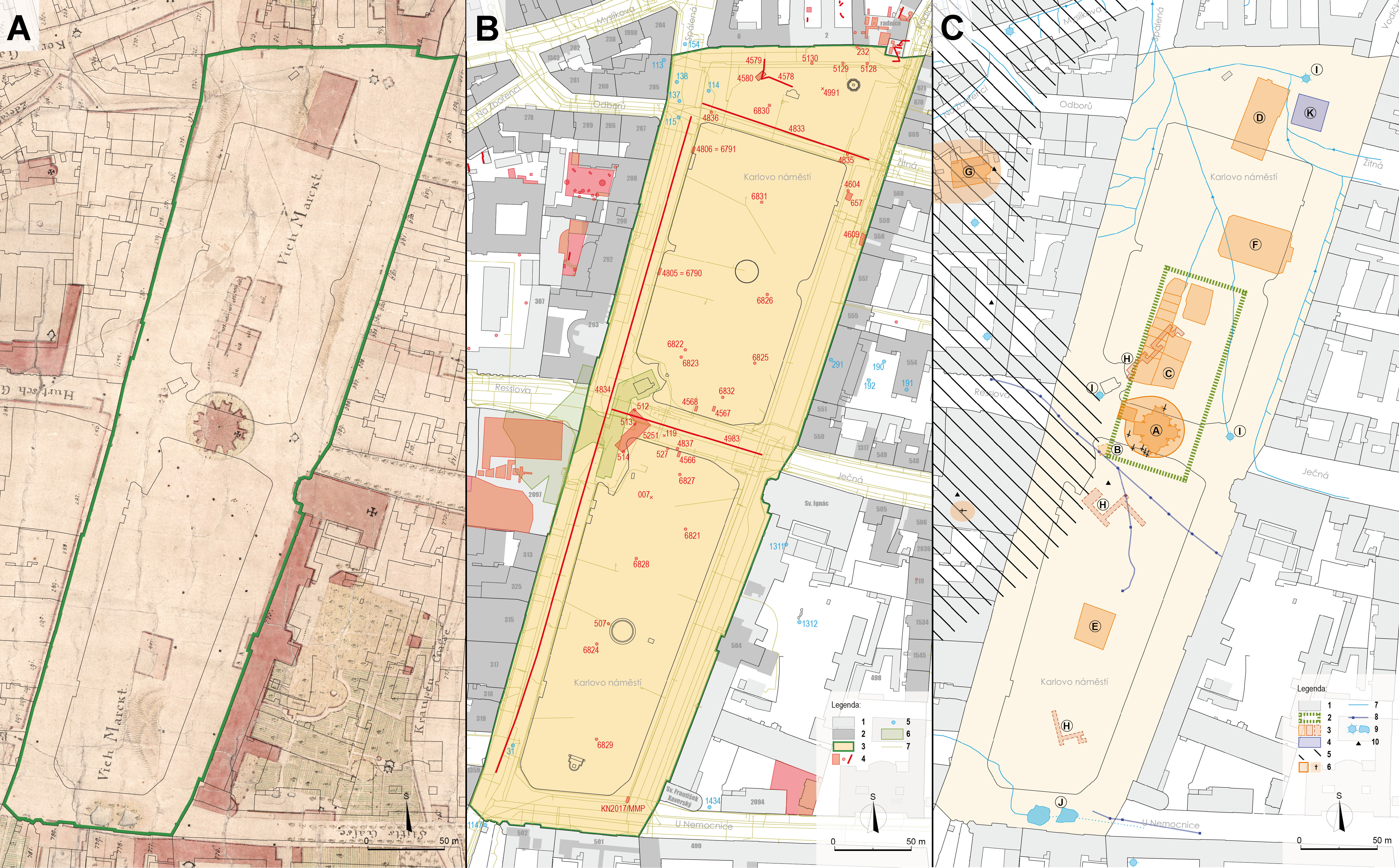
The initial phase of the VAP's development was informed by the findings of the grant-funded project Map of the State of Archaeological Terrains in the Prague Heritage Reserve. This project was conducted by the staff of the Archaeological Department of the Prague Institute of Heritage Care (now the Prague Office of the NHI) between 1996 and 2001. The resulting product was a map accompanied by a database containing the available information on the extent of disturbance to historical terrains within the Prague Heritage Reserve. The fundamental data employed was the digital reference map of individual cadastres, architectural surveys of Prague, plans of buildings from the municipal authorities' archives, and the MADB. Between 2000 and 2001, a map of the Prague Heritage Reserve's underground from 1969 to 1970 was incorporated into the project.
The aforementioned data was analysed and synthesised to create a map of areas with destroyed archaeological assemblages. This was achieved by extracting data for areas with excavated archaeological terrain, including cellars, underground spaces, underground vestibules, underpasses and collector entrances. The data was then linked to the map of properly archaeologically investigated sites registered in MADB. A spatial analysis of the conservation area was then conducted on the basis of these documents, so that the Prague archaeologists could identify areas with a high number of intact historical terrains, which were designated as VAPs (Figure 5). In addition to the aforementioned selection criteria, the location of the site in the context of the historical core of the city, and its connection to archaeological or architectural remains and finds, was also a significant consideration. The fundamental criterion for selection of the VAP sites was based exclusively on professional considerations, which could be substantiated on the basis of the current state of knowledge in the fields of historiographical and archaeological research, as well as building history research (Podliska and Tryml 2012; Podliska and Tomášek 2014).
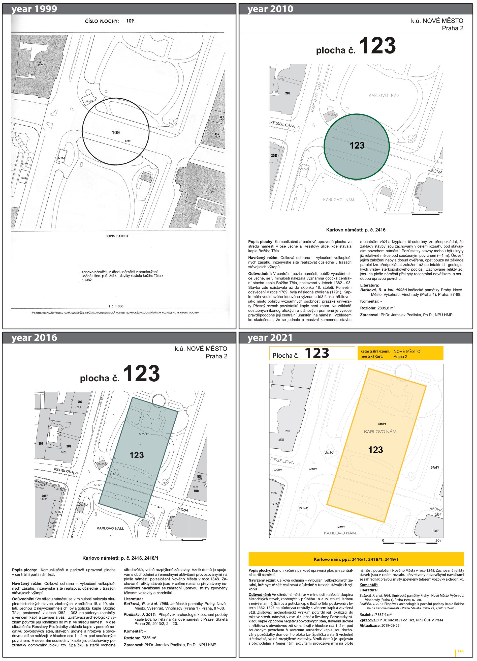
The VAPs can thus be characterised as intact archaeological 'preserves', comprising a sufficiently illustrative sample that encompasses all settlement components from the historical development of the site. As early as 1999, representatives of PAK identified 122 areas. The findings were presented to the Prague City Development Department for incorporation into the urban study of the Prague Heritage Reserve. Each area was accompanied by a brief explanation of the proposal and the recommended treatment regime, as follows.
In 2010, the VAP underwent a revision, resulting in the disappearance of seven areas (destroyed by new construction) and the proposal of 24 new areas. The outcome was a comprehensive register of individual areas, comprising a detailed description, an expert justification of the area's significance, a review of existing sources, and a recommended monument treatment regime. The total number of areas included in the register was 137, covering an area of 0.427 km² (i.e. less than 5% of the total area of the Prague Heritage Reserve). The findings were integrated into the Planning Analytical Materials of the City of Prague, where they were categorised as monumental phenomena, and into the Management Plan for Conservation of World Cultural Heritage of the Historic Centre of Prague (Cikán and Sedlák 2021). The most recent revision of the VAP was conducted in 2019–2020. During this period, five areas were destroyed by construction activities, 17 areas underwent modifications, primarily due to spatial corrections resulting from construction, and eight new areas were proposed (Figures 6 and 7). The catalogue was updated with a total of 140 areas (covering a total area of 0.412 km²; see NHI 2020–2021), and the VAPs were projected into all map applications of the IPR with an option to display standardised detailed information on the area polygon. The VAPs have been made available to the various stakeholders through NHI applications, namely the Information System for Archaeological Data (ISAD) and the Monument Catalogue
From the perspective of legal monument protection in the Czech Republic, VAPs do not have a separate status with a defined curatorial regime. However, in the case of Prague, they form part of the urban conservation reserve proclaimed by Government Decree No. 66/1971 Coll., where they are afforded legal protection under the supervision of the NHI. The protection framework extends to the archaeological layer, including finds where the VAP is located within the boundaries of a building registered in the list of immovable cultural or national monuments. In general, the guiding principle for the safeguarding of VAPs, such as those found in long-established agglomerations, is based on the European Convention on the Protection of the Archaeological Heritage (No. 99/2000; the Valletta Treaty).
While the archaeology of Prague is distinctive within the Czech professional context, its modernisation with regard to the utilisation of information technology is firmly aligned with developments at the Bohemian and subsequently national levels. As early as 1990, the Archaeological Database of Bohemia (ADC) was established as the inaugural initiative to systematically document the results of archaeological fieldwork. From the outset, the fundamental unit of recording was the 'fieldwork event', which encompassed individual excavations and other forms of field intervention or survey. Additionally, ADBs could be entered as an expanded description of the fieldwork events. In practice, however, this approach was not widely adopted, with data recording continuing to some extent in parallel in both the ADC and MADB. The subsequent phase of digitisation was linked to the rescue of the IAP-CAS archive, which was damaged by flooding in 2002. As part of this endeavour, the majority of documents stored in the IAP-CAS archive, including those related to research on Prague, were digitised. However, it became evident that no unified system existed for linking these documents with the detailed descriptions of fieldwork events contained in the ADC. To address this issue, the AMCR project was initiated. Between 2012 and 2017, the project resulted in the revision of select data sources, their harmonisation, and their integration into a unified information system that also included data from Moravia and Silesia. Furthermore, during the course of this work, the AMCR became the foundation for a comprehensive research infrastructure, the Archaeological Information System of the Czech Republic (AIS CR), which was incorporated into the national roadmap (Kuna et al. 2017).
In parallel with this process, archaeological conservation, overseen by the NHI, has been digitised. The NHI is a state-run organisation responsible for the protection of cultural heritage. It provides free assistance to the executive authorities and owners of monuments, ensures professional supervision, performs methodological and informative tasks, and is also a provider of data in accordance with special legal regulations (Act No. 20/1987 Coll., on State Heritage Management, §32; Act No. 283/2021 Coll., Building Act, §18, §176). At a national level, the NHI operates the Monuments Catalogue, a registration system containing data on the legal status of cultural monuments, national cultural monuments, conservation areas, protection zones, and other objects of interest for monument conservation. In the field of archaeology, the NHI has developed its own Information System on Archaeological Data (ISAD), which is used for the registration, management and presentation of Czech archaeological heritage. The basic components of this system are the State Archaeological List database and GIS, which document elements of the archaeological heritage as Areas with Archaeological Finds and reflects the legal definitions. Such areas have been established on the basis of prediction and the assumption that archaeological finds are generally present in the landscape. From an archaeological conservation point of view, it is not sufficient to define only the Areas with Archaeological Finds, but is desirable to try and protect archaeological terrains beyond the basic legislative treatment represented by preventive archaeological rescue excavations. Therefore, the ISAD database also records the most significant elements of the archaeological heritage as Valuable Archaeological Sites (VALs) and Valuable Archaeological Areas (VAPs). The VAL database comprises a register of scheduled cultural monuments of an archaeological nature, as well as unprotected objects that exhibit the characteristics of a cultural heritage fund. As previously outlined, the VAP represents an application of a more detailed scale in the context of the agglomerations (i.e. the Prague Heritage Reserve).
Another component of the overall structure, with a specific focus on Prague, was introduced by the Integrated Information System of Archaeological Sources of Prague project. From 2013 to 2016, it facilitated the digitisation of the MADB and, within its framework, a new Prague Archaeological portal was created, which became a platform integrating otherwise disconnected records and resources related to Prague archaeology (Boháčová and Podliska 2015). The portal serves a diverse user base, including professional archaeologists, conservation officers, municipal and state officials, private entities, and the general public with an interest in archaeology. All content is accessible without registration and is provided under the Creative Commons Non-Commercial licence (CC BY-NC 4.0). The portal's central feature is a map interface that enables users to view, filter and download datasets pertaining to Prague's archaeology and history, primarily managed by the IAP-CAS and NHI. The key scientific maps, such as the MADB and the contents of the Monuments Catalogue, are updated on a regular basis with data harvested from primary sources. Furthermore, additional supplementary map data and background layers provide contextual information. The portal also incorporates multimedia presentations designed for a general audience, which explain various facets of Prague's historical development. Following seven years of operation, this section of the website has become a valuable resource for students of historical sciences, effectively serving as a textbook on Prague archaeology. The portal also provides access to social media channels, including YouTube and Sketchfab.
One of the most popular featured videos is a reconstruction of the technologies used in the construction of the Charles Bridge in the 14th century, which has been viewed over two million times. The portal is now integrated into the framework of AIS CR services, and its maintenance and development are supported by a long-term interinstitutional agreement and collaboration between IAP-CAS and NHI. This integration ensures not only organisational and technical integration with other systems, especially AMCR, but also the future sustainability of the portal operation and management of its data content. AMCR is now the principal instrument through which MADB data is perpetually updated (Figure 8). The AIS CR employs a staff member responsible for related user support and data management, who also harmonises the methodological procedures for record keeping. The ADB data is indexed and presented both in the AMCR Digital Archive and in the Prague Archaeological portal, and transferred there via the AMCR API.
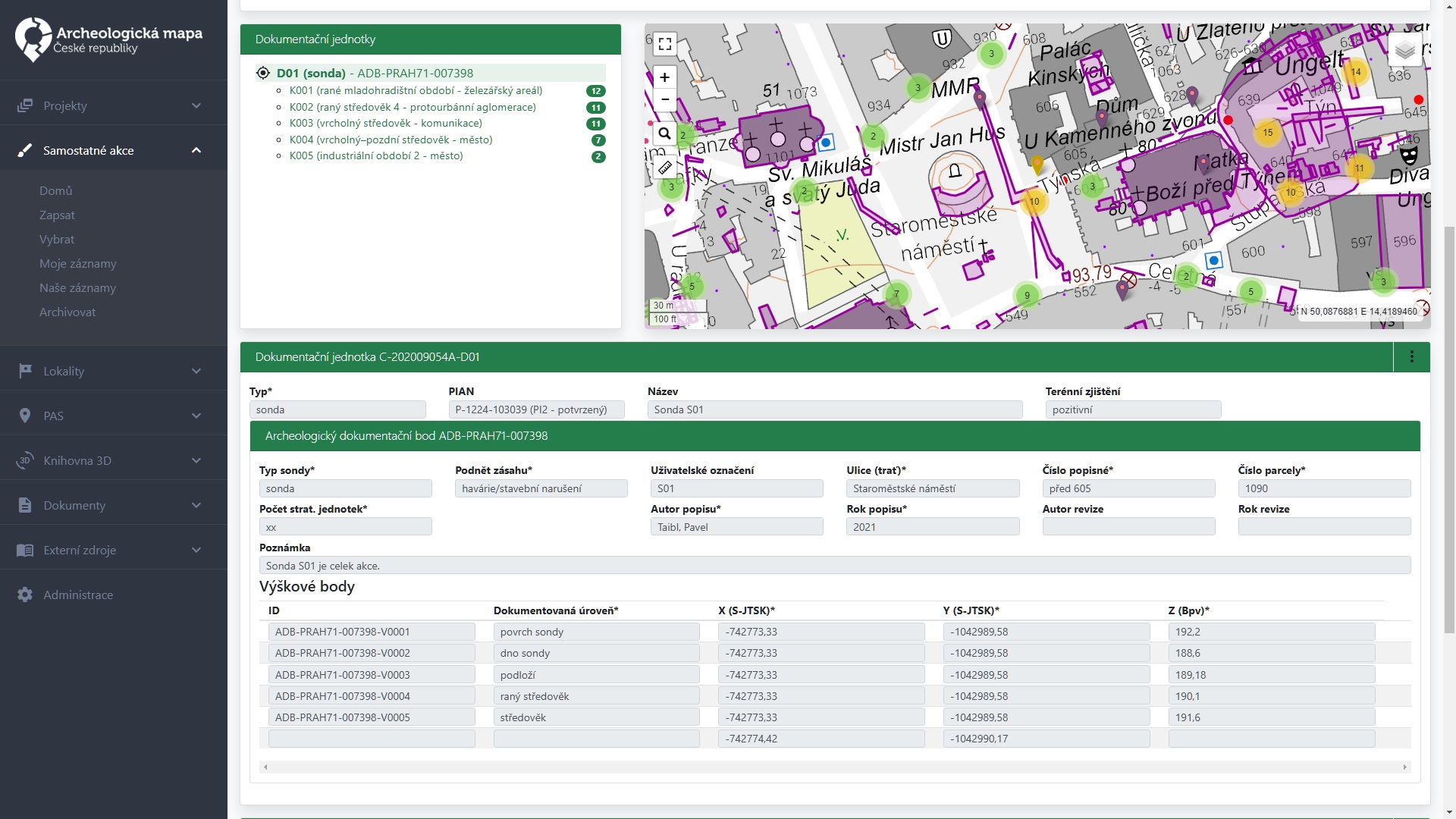
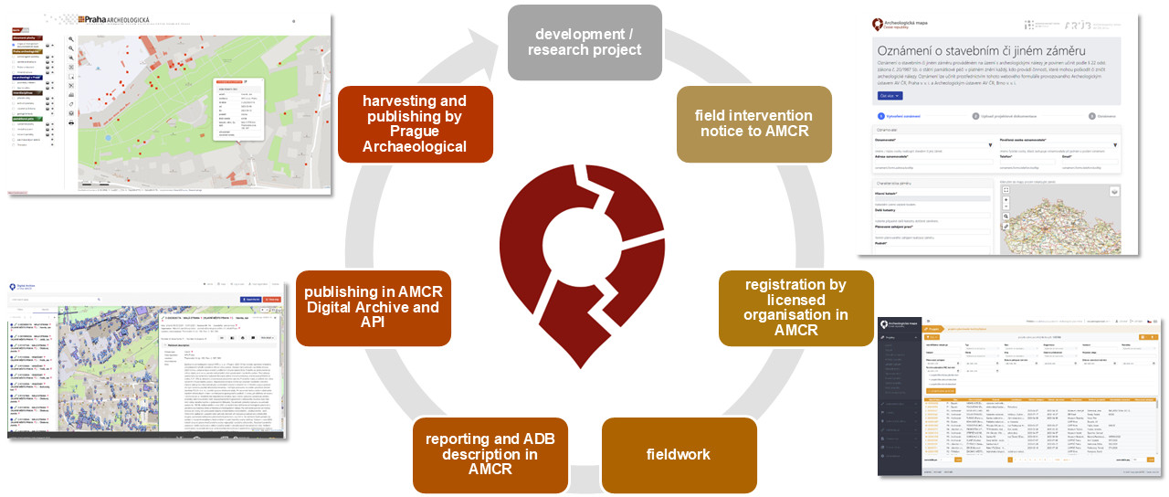
This approach has resulted in the establishment of a unified system that furnishes essential archaeological data related to the Prague Heritage Reserve throughout its lifespan (Figure 9), in alignment with the overarching principles enshrined in the legislation. The AMCR serves to notify prospective developmental plans, thereby creating project records. In collaboration with the PAK these projects are then taken up by the individual organisations that are licensed to conduct archaeological fieldwork. These organisations are responsible for managing the information related to the excavations in the AMCR as fieldwork event records; once the fieldwork has been completed, the results are entered into the AMCR, including those that are negative. Subsequently, in the case of surveys conducted within the Prague Heritage Reserve, ADB records and individual elevation points within them are also created and described in relation to the event record. This metadata is supplemented by documentation, typically in the form of a final report, which is a PDF document that summarises all the relevant information about the survey, including photographs, plans and lists, etc. (for more see Novák et al. 2021). This concept of reporting is based on current legal requirements and older professional practices. However, in the coming years, we anticipate a significant shift towards archiving primary documentation, which will be supplemented by a commentary in the form of a final report. This will be in accordance with the recommended principles outlined by Europae Archaeologiae Consilium (EAC) (Novák et al. 2024). Subsequently, the data is published in the AMCR Digital Archive and transferred to the Prague Archaeological portal. Both of these are public information resources that are utilised extensively by experts in the preparation of new research, as well as by the general public. However, the most pertinent aspect of the topic at hand is the subsequent sharing of data with the IPR.
The Czech approach to spatial planning observes the tradition of comprehensive urban planning across multiple scales (MMR 2022). This encompasses regional and municipal zoning planning, as well as the formulation of detailed regulatory plans. Zoning plans encompass the majority of the country's territory, delineating zones where construction is permitted. However, the lack of specificity in the zoning plans is such that they are unable to set out precise conditions for the protection of heritage and archaeological assets, given that they correspond to a relatively coarse scale of 1:5000. It can be argued that regulatory plans, which establish detailed and binding limits for individual plots, can be an effective tool for the protection of areas of archaeological significance. However, an issue arises when considering the limited scope of valid regulatory plans. Currently, across the entire city of Prague, only one regulatory plan is in force, covering 0.04% of the city (2% of the historic centre of Prague). The role of missing regulatory plans in Prague is compensated for by planning analytical materials and planning studies, which, although non-binding, are crucial documents that cannot be overlooked in land-use and building decision-making.
The objective of planning is to avoid unnecessary future losses and costs. The financial outlay required for urban development is considerable. The main risks associated with this undertaking are the unpredictability of changes that occur during the lengthy process of project implementation and the likelihood of exceeding costly contractual deadlines. It is no coincidence that the interests of developers and archaeologists frequently diverge. The planning and permitting processes can facilitate the identification and prevention of conflicts between opposing interests in time, or, alternatively, facilitate the resolution of such conflicts through the establishment of a compromise that mitigates the negative impacts of their collision. Consequently, the reduction of the unpredictability of archaeological findings in an area represents a pivotal collaborative research objective for both the archaeology and spatial planning disciplines. The greater the predictability of the archaeological finds, the more promptly planners can incorporate them into their work programme. The earlier conflicts or restrictions are incorporated into the planning process, the lower the overall costs of addressing them. A reduction in anticipated costs would therefore result in a more favourable approach on the part of developers towards the protection of archaeological heritage.
In the Czech Republic, developers may encounter potential conflicts with archaeological interests under three distinct scenarios.
A comprehensive account of the known and anticipated archaeological heritage in situ can prove invaluable in all three scenarios. In the initial case, it facilitates a more predictable timeline for subsequent construction activities in projects that have already been approved. In the second and third cases, it allows architects and developers to anticipate the extent of restrictions better during the building permit process. In all cases, the primary tool for conveying information about the area within the planning process is the so-called Planning Analytical Materials (PAM).
PAMs were established by Building Act No. 183/2006 Coll. (now replaced by Act No. 283/2021 Coll.) as a standardised database for the sharing and evaluation of information pertaining to the current state of the territory in the preparation of zoning and regulatory plans, as well as for decision-making by state building authorities. In Prague, the preparation of PAMs is the responsibility of the IPR, a municipal organisation established by the city council, which represents the city in spatial planning. The first edition of Prague's PAM was released in 2008 and, since then, there have been six complete periodic updates. The latest iteration of the PAM was released between 2023 and 2024. All the information is readily accessible to the public via the PAM Portal, PAM Atlas map application and the Georeport service. The content is divided into four synthetic maps and 13 volumes, comprising eight thematic volumes, four complex volumes, and one synthetic volume. The subject of archaeology is addressed in two chapters of the thematic volume (200 – City), in the complex volume (900 – Values and Limits), in the synthetic volume (1100 – Analysis of Sustainable Territorial Development), in the synthetic map of Land Use Limits, and in the synthetic map of Problems to Be Solved (in relation to conflicts between registered building intentions and limits).
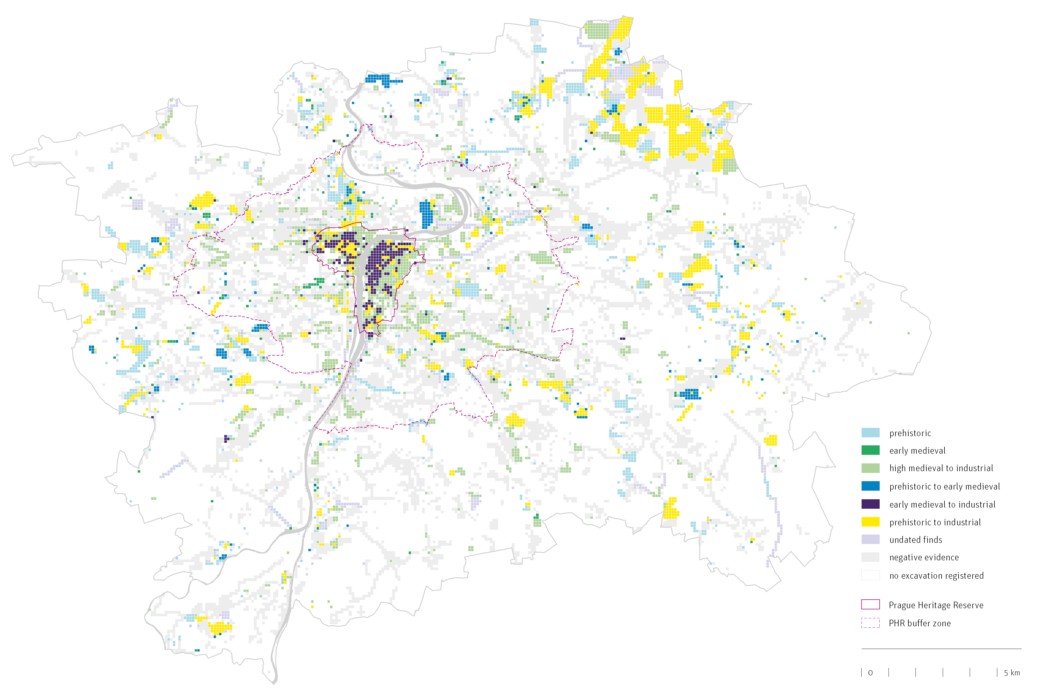
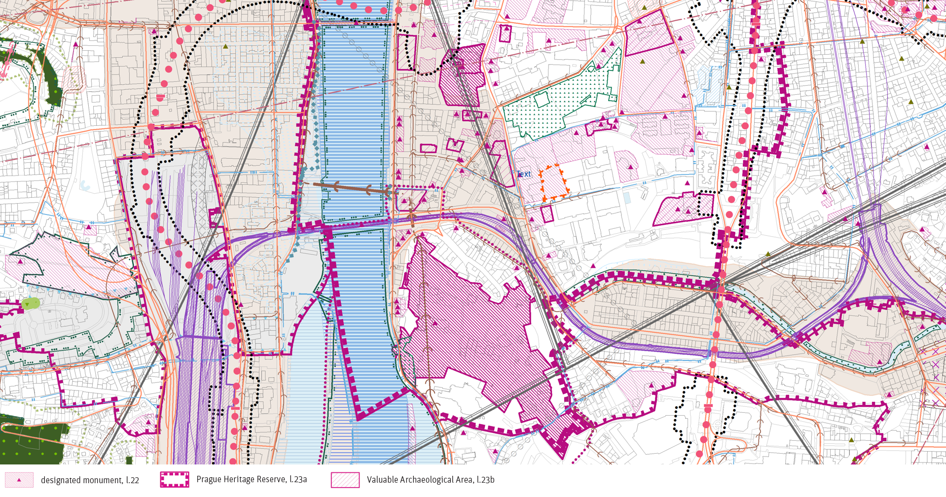
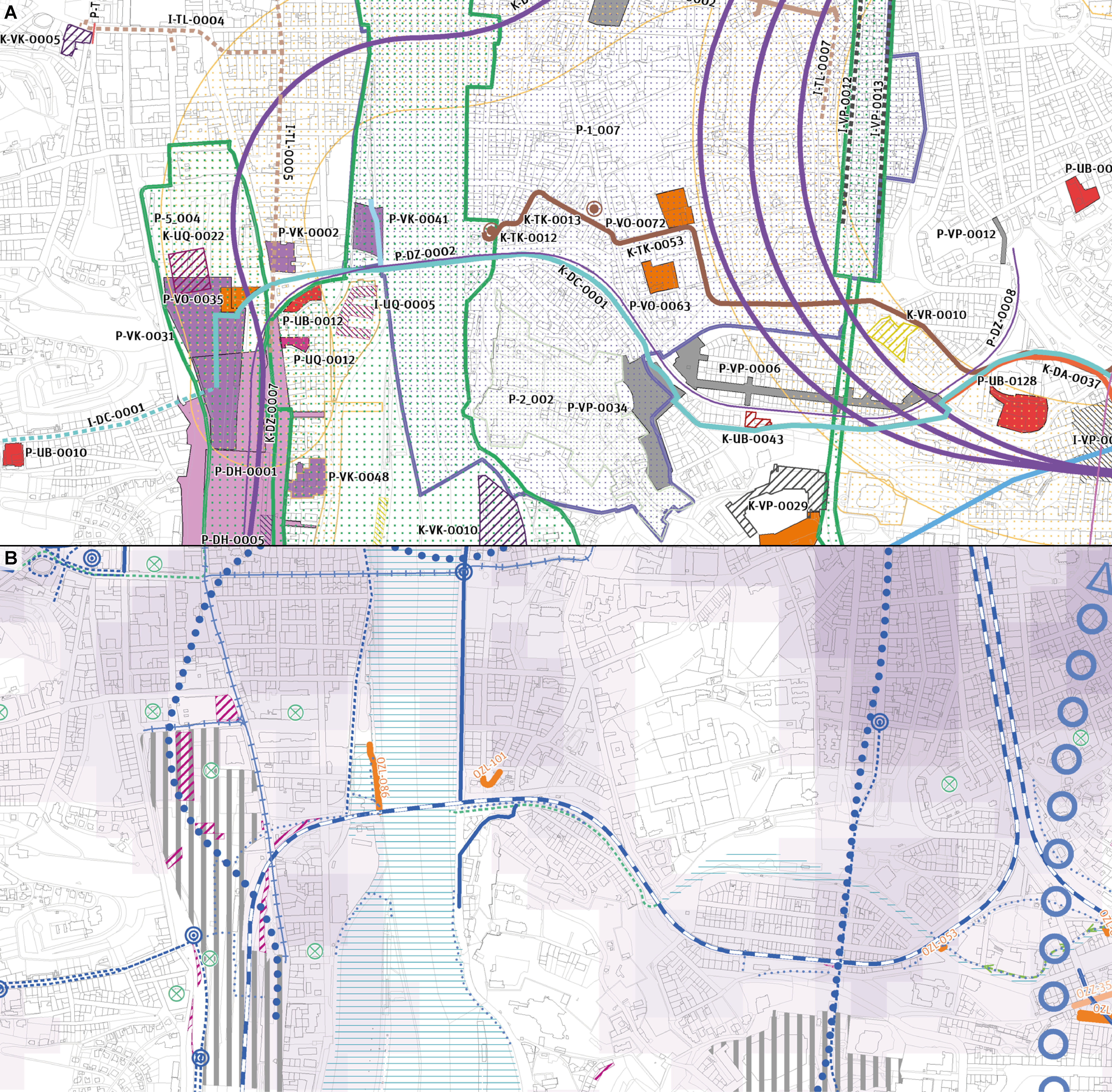
The delineation of registered archaeological monuments and areas with archaeological finds was recorded in the inaugural edition of the PAM in 2008. The VAP data layer was incorporated as an information resource in the 2010 update of PAM. However, it was the collaboration between IPR, NHI and IAP-CAS during the 2024 PAM update that led to a notable enhancement of the archaeology-related content. During this collaboration, the localisation of probable archaeological finds within Prague was refined, and the preventive protection of the updated VAP delineation improved. PAM 2024 presents, for the first time, a comprehensive display of the frequency and structure of archaeological finds across the entire area of Prague (Figure 10). This representation employs a 100m × 100m grid, which is also utilised for other analytical outputs within the Prague PAM (i.e. an identical grid is employed in the new municipal plan for height regulation). The display of this grid in the PAM map application enables developers and building authorities to readily ascertain the likelihood of encountering archaeological finds in a given area. Furthermore, the map offers a preliminary understanding of the current scope of archaeological exploration in Prague. To date, research has been conducted in only 33.9% of the grid squares, with positive findings in nearly 60% of these. VAPs were incorporated into the 2024 PAM update as part of the cultural–historical constraints on land use, integrated within the overarching land-use limits of the Prague Heritage Reserve (Figure 11). The incorporation of VAPs into these limitations enabled an evaluation of their consistency with documented development plans for the area. Consequently, a number of locations where VAPs may be at risk of being adversely affected by construction projects were identified and illustrated on the map entitled 'Problems to Be Solved' (Figure 12). Including the VAPs, the 2024 PAM identifies a total of 90 spatial limitations on land use, thereby providing the first indication of the presence of legal protections for public interests in the area for all relevant building authorities, designers and developers.
The subject of Prague archaeology also forms part of the assessment of sustainable territorial development, which is a compulsory synthetic component of the PAM update. Monitoring the development of selected data series (metrics) enables the desired goals outlined in municipal and state strategic documents related to the UN's Sustainable Development Goals to be achieved and evaluated. The PAM Portal utilises data from the AMCR to publish time series demonstrating the archaeological rescue fieldwork conducted on VAPs since 1998 (m.0200.02.003) and projects reported to the IAP-CAS since 2010 (m.0200.02.004). While this data is not directly pertinent to the safeguarding of archaeological finds in situ, it offers insight into the efficacy of the city and state in adhering to the commitments they have made with regard to the protection of archaeological heritage.
Archaeological sites in Prague represent one of the most endangered categories of historical sources. The principal cause of this phenomenon is the sustained growth in the number of construction projects, which have recently reached significant proportions. Archaeological finds are one of the primary sources of information about our past, particularly for the prehistoric and early historical periods. The removal of an archaeological layer containing finds is irreversible and irreplaceable. The preservation of the archaeological heritage through the institution of archaeological excavation can therefore only be understood as the preservation of some finds and information about the settlement development of the site before its final destruction, but not as its thoughtful protection.
In accordance with the stipulations set forth in the European Convention on the Protection of the Archaeological Heritage (the Valletta Treaty), it is imperative that “archaeologists, town and regional planners systematically consult one another” (Art. 5, para. iii) in order to modify development plans that may have a negative impact on the archaeological heritage (para. iv). An advantage of such collaboration is also the considerable reduction in time and cost for all parties involved, including the contractors. The success of this process is dependent upon the availability and sharing of related surveys, inventories and maps of archaeological sites by interested parties (Art. 7, para. i). Nevertheless, the practice is not always optimal, as the interests and priorities of stakeholders are not always aligned. As evidenced by the case of Prague, the only way to ensure quality decision-making that prioritises site conservation is through transparency and openness. To achieve this, it is essential that clear data pipelines and appropriate digital environments are established for seamless data collection, publication and data-driven decision-making. This must be accompanied by the coordination of relevant stakeholders, as this is a necessary condition for success. In addition, continuity (as evidenced by the fact that the datasets under discussion were created over decades), a clear strategy (as demonstrated by the MADP and VAP approaches) and a strong institutional background are key factors for long-term sustainability and relevant impact.
The MADP dataset is of significant importance to professionals in the field. This may appear to be a narrow focus, but without its contextual information it would be impossible to establish the concept of VAPs: it would not be possible to determine what is important and what can be removed after proper archaeological excavation. It is necessary to accept that in an urbanised environment, even in cases where the heritage in question is as valuable as that of the Prague Heritage Reserve, some losses are inevitable if a city is to develop. It is of the utmost importance to develop a meticulous and well-informed strategy for ensuring the sustainability of this development, including with regard to the management of archaeological heritage. The example of Prague demonstrates that there are avenues for achieving this, albeit imperfectly, through the collaborative efforts of the relevant stakeholders, even in the absence of direct regulatory intervention and legal changes. It is essential to translate these best practices into the latter.
The objective of the VAP project is not to impose constraints on urban development through the implementation of conservative protection measures. Instead, it seeks to facilitate an open discourse on the necessity of specific construction interventions in areas of high conservation value. The project is founded upon objective data, which is intended for dissemination not only to professionals, but primarily to the general public, including representatives of the state administration and local government, owners and entrepreneurs. The material should be integrated into all deliberations pertaining to construction activities within the historical core of Prague, in conjunction with surface earthworks. It is important to note, however, that using of the VAPs should be regarded as an open concept, subject to regular revision and supplementation with new findings emerging from the continuous archaeological research conducted in the city. The concept of significant areas is founded upon the stipulations of the Valletta Treaty, which asserts that archaeological discoveries constitute a vital component of historical inquiry and serve as a conduit for historical and scientific investigation. The objective of these endeavours is to establish a policy that ensures a balanced approach to the protection, conservation and enhancement of sites of archaeological interest, taking into account land-use planning and various construction or other development projects. This is exemplified in practice by the incorporation of VAPs into the development of analytical planning materials (i.e. PAMs), which are managed by institutions that are not within the field of archaeology. The impact of contextualising this information by means of detailed maps based on AMCR records has yet to be evaluated. Nevertheless, the preservation of a selection of the most valuable archaeological sites in the historic centre of Prague represents a significant step towards the responsible and meaningful protection of our cultural heritage, which clearly includes archaeological sites.
The process of heritage management is one that requires a significant investment of time before any tangible results can be observed. This is particularly the case when a solid knowledge base is required to work with it. The city of Prague benefits from a long tradition of systematic archaeological research, which is based on the cooperation of several institutions. The archaeological record is relatively complete, with information available on what has been found, where and when. In addition, there is detailed information on the archaeological stratigraphy of the city. The primary objective of heritage protection is the Prague Heritage Reserve, which encompasses the historical nucleus of the urban zone within the original Prague city walls. The data is presented as the MADP on the Prague Archaeological portal and curated through the national information system, the AMCR. The derived information is employed in the delineation of VAPs, which are defined as sites exhibiting exceptional characteristics within the context of the present archaeological landscape. To date, 140 such areas have been defined and described in Prague. The advantages of a transparent definition of heritage priorities are evident in the collaboration with the Prague Institute of Planning and Development, which utilises the data to gain a deeper understanding of the requirements of heritage management, and incorporates these insights into its strategic decisions and recommendations. It is evident that there are still numerous instances where even well-known and highly valuable heritage sites are adversely affected by development projects. Conversely, the number of such cases is relatively limited, and they can be regarded as inadvertent shortcomings of the system, which continues to rely on non-binding professional opinions and encounters challenges due to competing interests at various levels. Nevertheless, enhancing the system's transparency and accessibility facilitates a more constructive exchange of arguments, increasing the probability that they will be duly considered and reflected in development planning processes.
This peer-reviewed article was prepared on the basis of institutional support for the long-term conceptual development of a research organisation provided by the Ministry of Culture and the research infrastructure project Archaeological Information System of the Czech Republic (LM2023031). The submitted text was translated and edited using DeepL.
Internet Archaeology is an open access journal based in the Department of Archaeology, University of York. Except where otherwise noted, content from this work may be used under the terms of the Creative Commons Attribution 3.0 (CC BY) Unported licence, which permits unrestricted use, distribution, and reproduction in any medium, provided that attribution to the author(s), the title of the work, the Internet Archaeology journal and the relevant URL/DOI are given.
Terms and Conditions | Legal Statements | Privacy Policy | Cookies Policy | Citing Internet Archaeology
Internet Archaeology content is preserved for the long term with the Archaeology Data Service (ROR). Help sustain and support open access publication by donating to our Open Access Archaeology Fund.
 Home
Home