Cite this as: Arrington, N.T., D'Acri, A., Baloukidis, D. and Tasaklaki, M. 2026 Always in the Field: Introducing the WebDig App, Internet Archaeology 71. https://doi.org/10.11141/ia.71.13
In 2016 the iDig application for field archaeologists was hailed as "a recent and impressive addition" to the available digital tools for collecting data (Uildriks 2016). Created by Bruce Hartzler and Georgios Verigakis for the excavations of the Athenian Agora conducted by the American School of Classical Studies at Athens, the application, designed for iPads, is now in its 16th version and is successfully used by many projects, particularly in Greece, but also in Italy and Turkey. In this article, we describe integrating the iDig application into the workflows of the Molyvoti, Thrace, Archaeological Project (MTAP) and the advantages it presented to our processes and to the quality of our data. But we also point to the challenges it created for collaboration and the limitations with regard to traditional forms of publication. We offer one solution, which other projects can employ and adapt.
In celebrating tools like iDig, there is a risk of privileging the accumulation of data and overemphasizing efficiency for the sake of efficiency. These two goals are intertwined: publication is a means of preserving (in some form) the record of the past, while conservation safeguards ancient remains for future study. With regard to these goals iDig has limitations. At the same time, MTAP faced challenges with the traditional methods of print publication (see also Garstki et al. 2020). Despite more than 700 pages of print in the final publication of a Classical house (Arrington et al. 2025), artifacts were omitted and contexts divided. To address the problems we encountered, and to advance our goals of preservation and publication, we developed an open-source, web-based application, WebDig, which employs the data gathered by users in iDig and mirrors much of its functionality (see also Tasaklaki and Arrington 2024). The code for WebDig is freely available on GitHub for users to adapt for their own projects.
In this article, we first present our experiences moving from paper to digital recording in the field as iDig users. Then we discuss the limitations of iDig and the solutions presented by WebDig for collaboration. A detailed and technical discussion of WebDig and its structure, organization, and capabilities follows. We then discuss how the program facilitates project publication, promoting open access and the dissemination of project data.
Located on the north coast of Greece, the Molyvoti, Thrace, Archaeological Project (MTAP) is a cooperation between the Ephorate of Antiquities of Rhodope and the American School of Classical Studies at Athens, represented by Princeton University. The Greek directors are Domna Terzopoulou and Marina Tasaklaki, and Nathan Arrington represents the American School. The project explores, among other topics, trade networks, city-country relations, interactions between Greeks and Thracians, and diachronic change, investigating a site (40°56'08.2"N 25°17'15.4"E) often identified as Ancient Stryme in its broader regional context. Settlement here began in the 6th century BCE and continued into the 4th century BCE, ending ca. 300 BCE and reviving in the 4th century CE. Activity in the wider landscape started earlier and lasted longer.
Excavating two Classical houses and a Hellenistic temple, among other architectural features, and surveying the hinterland, the project has produced abundant data over the course of field seasons in 2013–2015, 2019, and 2022–23. Like many projects, our recording methods changed over the years. In the first campaign (2013–2015), the team recorded information on paper context sheets in the field and then entered the information into an Access database on the main computer of the project, in the afternoons and evenings. Photos were taken with a camera and uploaded into one folder while hand-drawn drawings and top plans were scanned and uploaded to another folder. The process of data entry was time-consuming and susceptible to human error, and different types of data existed on different computers. Specialists had limited ability to contribute to the main database and typically created and operated their own, separate databases. These recording methods made it difficult to share new insights across specialists and with those excavating in the field (on this problem, see Faniel et al. 2021: 3–4). The physical location of participants – the workroom/lab for the specialists and the field for the excavation supervisors – exacerbated the problem.
In response to the limitations of this system, in 2019, MTAP began using the iDig application, which Bruce Hartzler and Georgios Verigakis had created for the Athenian Agora. With iDig, excavation supervisors in the field recorded born-digital contextual data, such as soil descriptions, directly into the iPad application. Photogrammetric orthomosaics were generated and updated on the iPads weekly, forming the base plan over which other data was mapped. With live links to a total station, users could collect and immediately visualize in iDig such spatial information as the contours of a context or the findspot of an artifact. Users took digital photographs with the iPads that were linked immediately to the information they were recording, such as the opening and closing of contexts, and artifacts in situ.
Outside the field, specialists working with related material in the workroom could add data to iDig using other iPads, and the director synced all the information on a daily basis. For example, a supervisor might have excavated a context over the course of several days, from which the pottery and bones were washed and studied at the off-site workroom; in other words, the context was dug while associated ceramics and other finds were being processed. In the afternoons, specialists took photographs and added information from preliminary ceramic and osteological analyses conducted in the workroom to iDig on their iPads, which were synced daily with the supervisor iPads. Thus, the supervisor in the field the next day was aware of the most up-to-date findings as they excavated, such as the date and formation process of their context based on the ceramics and bones. Meanwhile, the specialist studying the bones could use his iPad to access the most up-to-date photographs and descriptions of the context, deepening his understanding of the matrix in which the bones were found, the circumstances in which it was found and the methods used, and how the deposit related to the rest of the site history. iDig thus interlinked both objects and people, facilitating collaboration and knowledge-sharing, which we found increased in-person dialogue. The powerful visualization capability of the app, which shows contexts and artifacts in their spatial setting, deepened understanding of the site while inviting exploration and manipulation of the data.
In addition to improving the interlinked nature of the data and the personnel, we found that iDig significantly accelerated the recording process and eliminated errors. Using drop-down menus as well as free-text entry fields, supervisors recorded all the information they would have noted by hand, while receiving prompts to abide by site-wide standards, such as nomenclature. Since the data was born digital, there was no need to enter it again into a separate database at the end of the day. The data was backed up on a weekly basis and stored on multiple devices. In increasing efficiency and reducing error, iDig thereby allowed supervisors to devote more time to pottery reading, and to analysis and interpretation. The photogrammetric models combined with the use of a total station also obviated the need for the time-consuming process of making top plans by hand (this drafting skill, which we consider valuable for archaeologists to learn, was still assigned to graduate students on occasion for training purposes). In the first weeks of adoption of the tool, some supervisors elected to keep a separate paper notebook but all soon used iDig exclusively. In addition to recording specific details such as the color of soil, iDig provided space for keeping an ongoing, discursive log of work, serving the same purpose as a traditional notebook of preserving important documentation about what the archaeologists thought they were doing and why, giving a narrative of the excavation.
iDig has been used on numerous other archaeological projects, including the Ismenion Hill Excavation (Thebes), Ancient Corinth Excavations, Thorikos Archaeological Project, Keros Project, Teos Archaeology Project, Eretria Excavations (ESAG), Amarynthos Sanctuary of Artemis (ESAG), and the Valle Gianni – Northwest Bolsena Archaeological Project in Italy. It is among a number of digital tools available to archaeologists, which raise new possibilities, but also presents some limitations (Psarros et al. 2022; Moullou et al. 2024; Rabinowitz 2016). Like other archaeologists, we are concerned that speed should not be the ultimate goal of digital recording (Caraher 2016), and we recognize that improved digital recording is only one step in a broader scholarly endeavor. In particular, recording needs to lead to publication (Kersel 2016, 486–87) and to preservation. Interpretations of the meaning of these two terms will vary for different archaeologists and across different archaeological projects. Few (if any) projects will result in a paper monograph including every find at the site along with a visitable archaeological park. Yet all projects should aim for a thorough presentation of a significant amount of data, if not all the raw data, advancing their members' interpretations while allowing other scholars to pose different questions and formulate different conclusions. And given the destructive nature of archaeology, concern for preservation should be built into the design of a project from the beginning. These twin goals of publication and preservation are intertwined in many ways. Presenting material in digital or print format is a type of preservation, while traditional site and object conservation requires considerable scholarly study and leads to increased access to the material, much like a publication.
We encountered limitations in iDig precisely in the crucial post-season activities leading to publication and enabling preservation. Designed above all as a tool for users to gather data in the field, iDig for an iPad is not ideally suited for storing large amounts of data and facilitating post-season collaboration. At the same time, iDig opened a path to what might be possible: the creation of a web-based application that could mirror much of the functionality of the iPad app, bringing iDig’s relational databases and visualization tools to post-season specialists. Such a tool also would be able to communicate to a much wider audience than specialists, increasing the impact of the project, engaging with a broader audience – not least, the local community – and creating a digital preservation of the project and its finds. Since many projects are already using iDig, a tool designed specifically for this platform could lower the barrier to the dissemination of digital data.
Despite the advantages of iDig in gathering data, we faced several challenges when preparing the project's first final publication, which focused on the 2013–2015 campaign (Arrington et al. 2025; full list of project publications here). No iPad had enough storage space to hold all the project data, as opposed to the data from only one excavator during one season. And the database could not be synced on iPads across vast distances, so researchers had to decide who would have the "master" database with the most up-to-date information. As scholars worked on their material, they added dates, drawings, and information, which were relayed to the person with the master database, who would input the data onto his device, but there was no convenient way to relay the updated information to the other scholars. Scholars studying the finds post-season worked in isolation from each other and often remained unaware of one another’s findings. For example, the numismatist could not readily access information about amphoras from a given context, hindering analysis of trade networks and domestic economies. The archaebotanist and zooarchaeologist, concerned with distinguishing plant and animal use from the Classical and Roman periods, were not aware of how pottery readings had changed the date of a locus. Coin dates that ultimately confirmed the suspected early Hellenistic dating of some lamps were not relayed to the specialist studying the lamps. The directors and their computers, holding the master database, were the repositories of knowledge, but they could not predict what collaborators might need to know and struggled to facilitate dialogue. While our in-field record-keeping gathered and preserved all data, the collaborative aspects of the archaeological project – those very aspects that iDig had so positively facilitated – were lost in the post-season.
WebDig makes the collaboration that was so useful in the field possible outside of the field, in the post-season. The relational nature of the platform means that a change, such as a new locus date, will immediately be reflected in the contextual information that someone sees who is studying an object from that locus. Users can see what changes have been made lately on the program and how it has been employed. The program maintains flexibility so that new categories, sub-categories, and other data fields can be added as necessary. These adaptations, however, and the granting of differential levels of access do require the dedicated attention of someone with IT skills.
WebDig’s goal is not to replace iDig, but rather to extend it and fix some of its limitations for data storage, data presentation, and work flow. While there is a risk of creating too many bespoke databases and idiosyncratic methods when developing new tools (Sobotkova et al. 2021, 571), given the number of projects using iDig, we anticipate that there will be some broad appeal to this new platform. Thanks to its flexibility, ease of use, and its aim to assist scholars in their research, WebDig could also be adopted by other projects as well, not just those who use iDig for their excavations.
WebDig is a customized web-based extension of iDig, a FileMaker-based system limited to Apple systems. WebDig was developed to extend iDig’s core functionality – including the integration of topography, stratigraphy, and artifact data – into a browser-based application that could be used on any device with an internet connection. The artifacts gathered during pedestrian surface survey are included in WebDig, since the same specialists study and publish the artifacts from both excavation and survey. Material from survey, however, does not yet have viewable spatial information on WebDig, since we did not use iDig to gather the survey data in the field.
The transition from iDig to WebDig ensures that all project data remains organized, searchable, and interoperable long after the field season ends.
WebDig has a user-friendly interface, but it is still a work in progress, and we fine-tune the platform as we receive feedback. Our goal is to maintain flexibility so that different projects can tailor the platform to their specific needs.
To better understand how to browse and use WebDig, we will guide the user through the current version of WebDig adopted by MTAP. Once the user logs in as a guest, he sees a dialogue box with information about permissions, and then lands on the homepage (Figure 1). It has three main parts: in the center, there is an excavation plan (here, the House of Hermes); on the top, a toolbar with several functions that will be examined below; on the left, a pane with a search bar along with items associated with the House of Hermes. Below the pane, from left to right, there is a show/hide categories panel, the number of items within the trench (in this case, 2099/7892 are related to the House of Hermes), and an advanced features tool, which will be explained below.
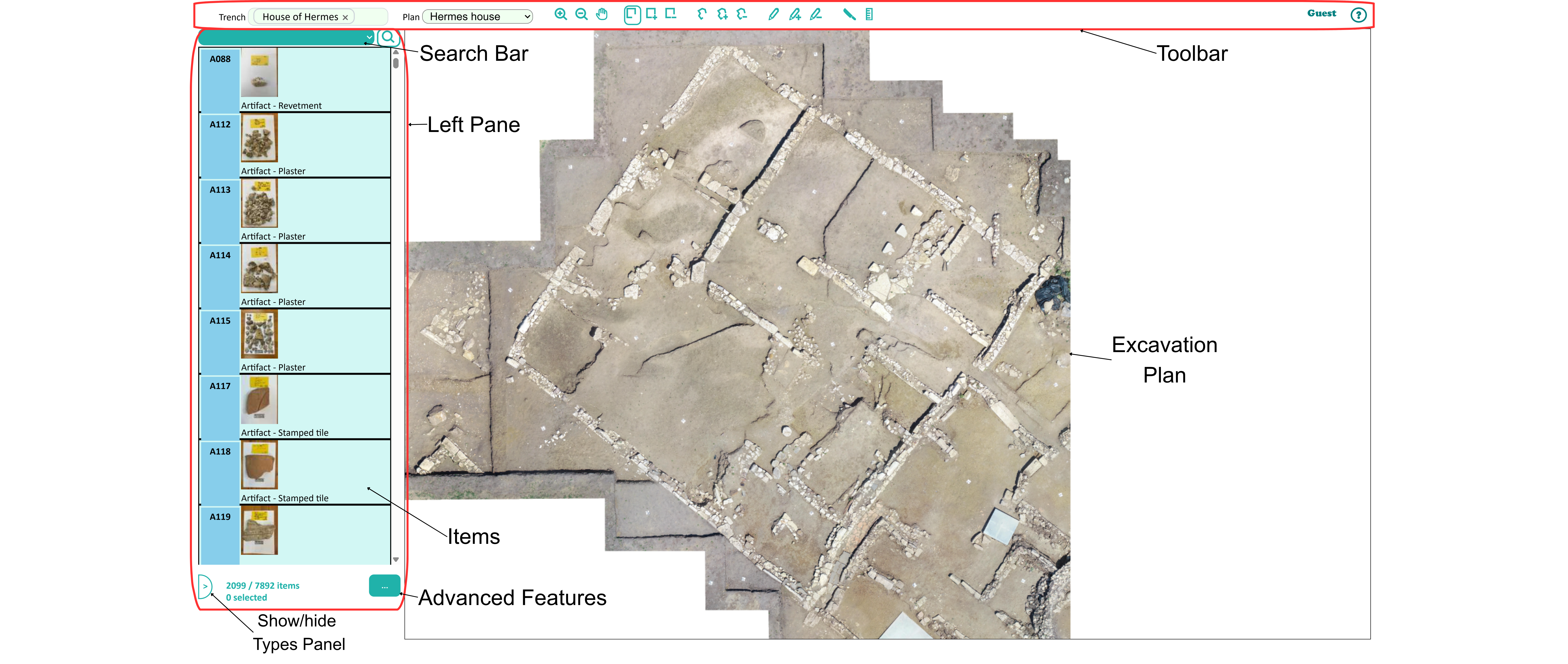
Going into more detail, starting from the upper horizontal toolbar the user finds the following functions. In Trench, they select the area of an excavation that has been organized into one coherent unit. On MTAP, for example, the House of the Gorgon is one trench and the House of Hermes another. The plan allows them to select a different base layer, such as an orthomosaic for the house from different excavation dates. At the center of the toolbar, there are symbols indicating tools the user could use: zoom In  ; zoom Out
  ; drag and move
  ; select items and features from the plan using a rectangle,
  ; select from the plan with a polygon
  ; select from the plan using a pencil with adjustable width
  ; create a cross-section of the selected Items
  ; and display lengths of selected items on the map
  . At the right of the bar, there is information about the User (here, "Guest") and a Help section
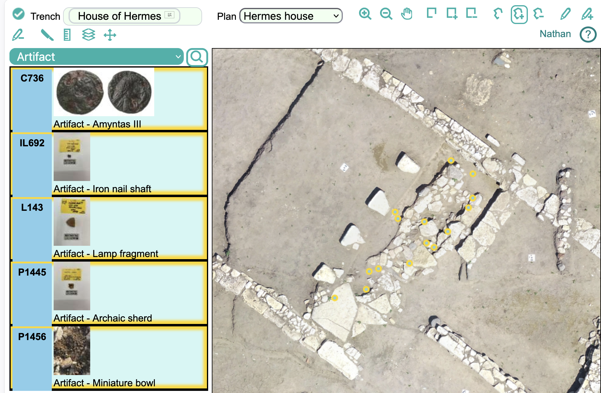
  . To take an example, in Figure 2, the User (here, "Nathan") has zoomed into a room that the excavators think may have been a kitchen. He asked the program to display all the artifacts from the house, and then he used the polygonal tool to select only those artifacts from this room, which now appear in the left pane. Records in this left pane can be searched and sorted. They are organized by "types" (Figure 3): artifacts, features, images, locus (a context or stratigraphic unit on MTAP), and partition (any aggregate body of material belonging with a locus, such ceramics, bones, or shells). Rather than look for the artifacts in the possible kitchen, the user may, for example, have searched for all the loci.
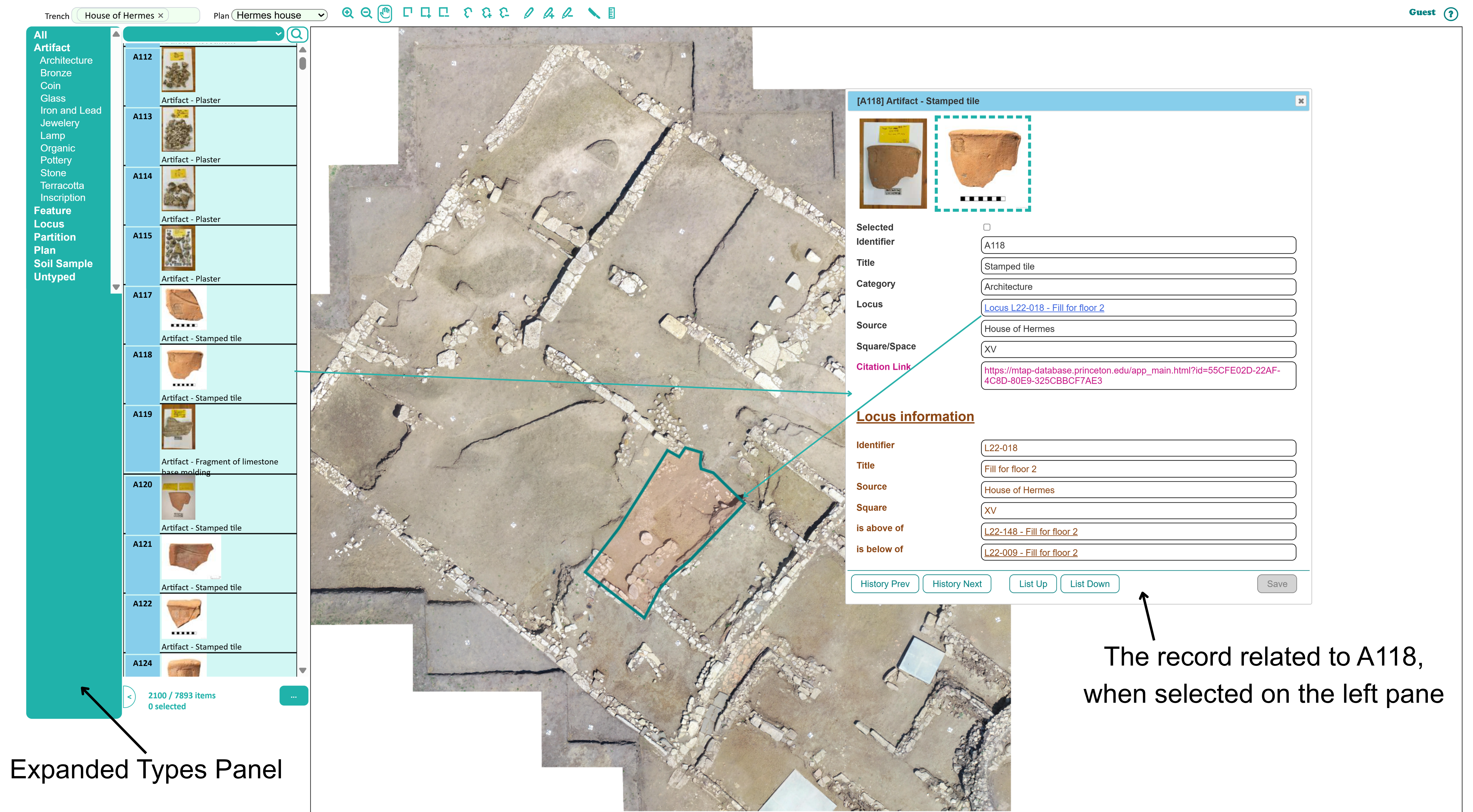
WebDig enables users to search for and examine objects in various ways. By selecting one of the types from the types panel, one can see all the specimens of a particular artifact type inventoried (Figure 3). The image shows what happens when the user has selected a specific item from the left pane: a new window appears, opening the record associated with that specific item, in this case, A118, an Artifact, inventoried as a stamped tile, and all the information (including photos) that the user can have access to. On the orthophoto, the spatial parameters of the locus (context) associated with A118 also appear. The user can click on the locus link (here, Locus L22-018) to obtain further information about the context.
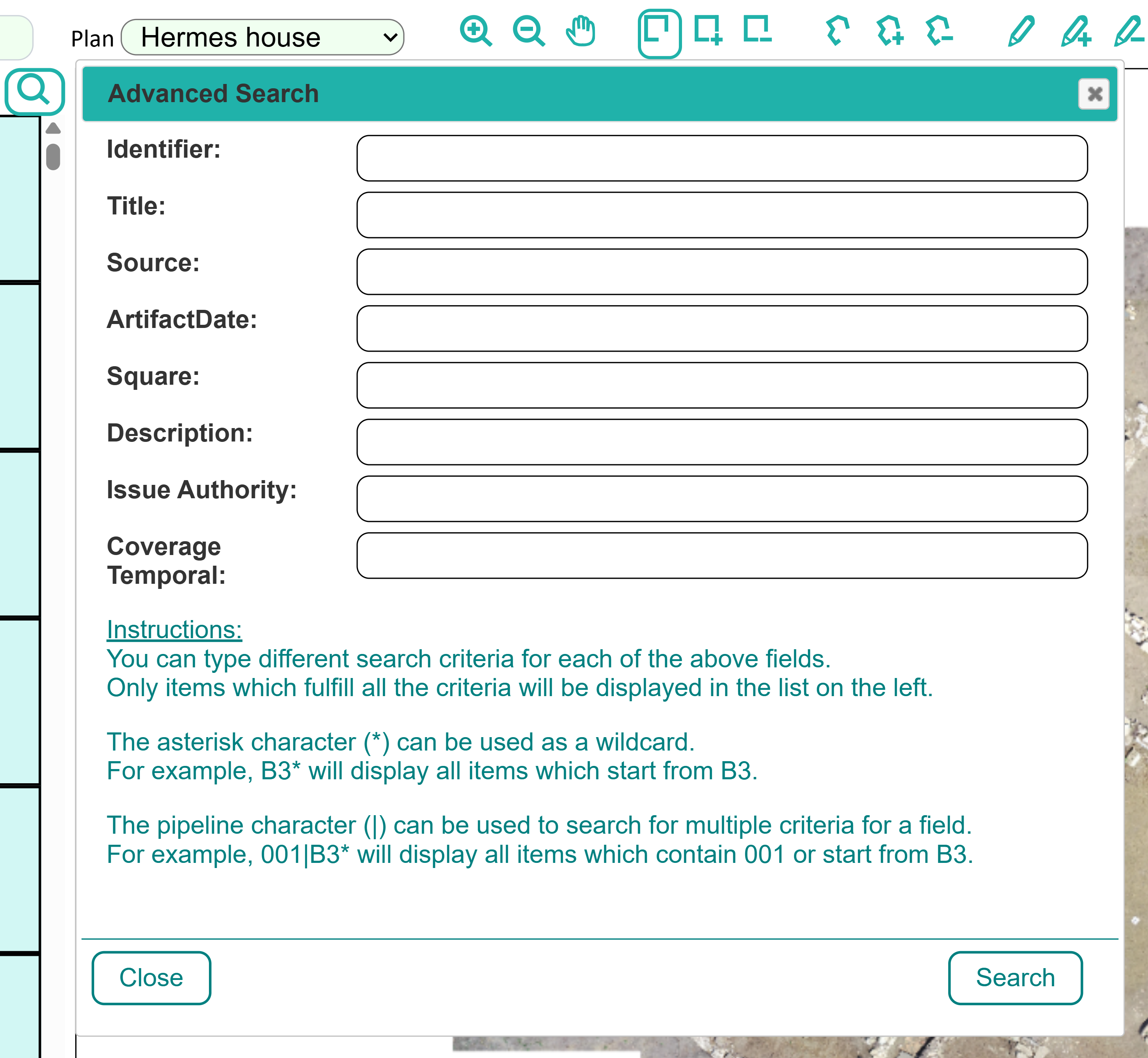
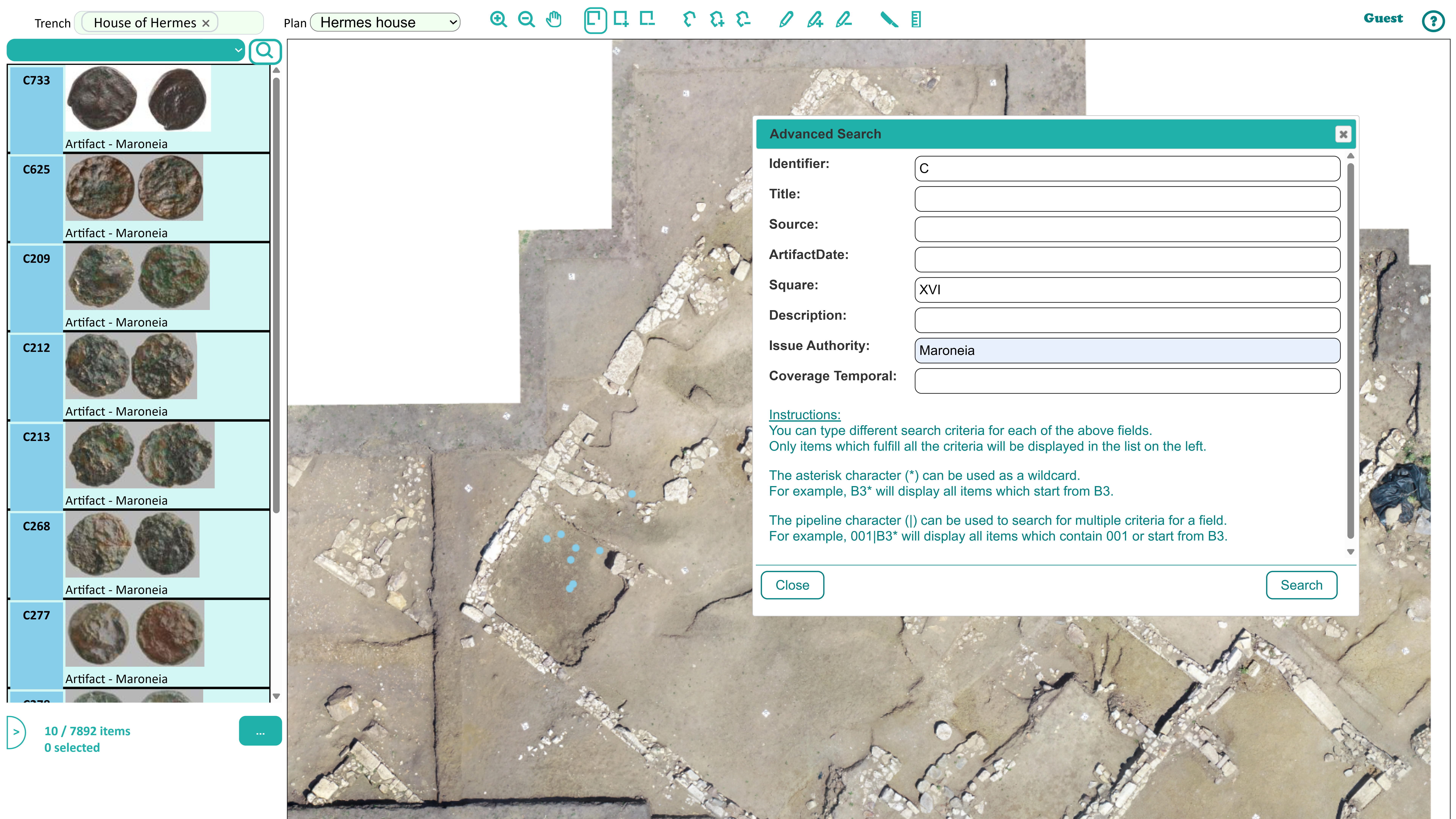
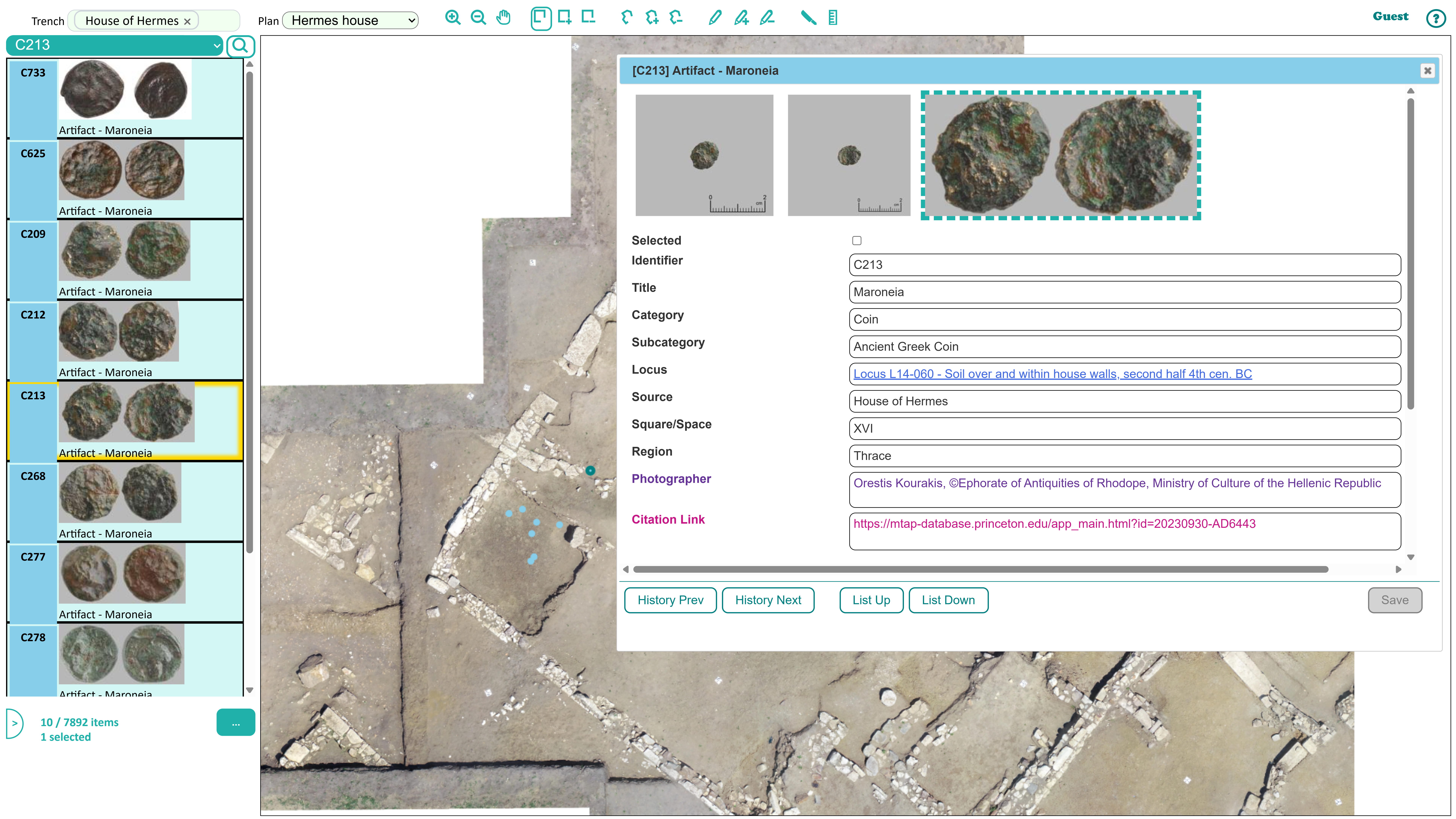
WebDig also supports more complex research inputs. Clicking on the  icon below the left pane opens an advanced search tool. The advanced search (Figure 4) includes many criteria, facilitating the search for specific items. On MTAP, for example, researchers have found it useful to search by such parameters as the square where an object was found or the issuing authority of a coin. For instance (see Figure 5) a user can search for all coins from Maroneia that have been found in Square XVI of the House of Hermes. The user will find 10 items, all indicated by blue dots on the orthophoto. The user could now look for the location of specific items within the search, clicking on them on the left pane while holding CTRL (Figure 6 and Figure 7). Depending on the type of user and their degree of access, the item selected would provide different degrees of information.

The code for WebDig is freely available on GitHub. In this section, we explain some of the technical aspects of the program, particularly the way the program structures the data. The WebDig application is based on a client-server architecture, with the client running on the web browser and the server running on a web server. The client has been implemented in JavaScript and the server in PHP. The data are stored in JSON format. Effort was made to use only the necessary libraries in order to preserve the longevity of the project. The choice of technologies was based on their wide availability and their establishment as proven industry standards. This ensures that the installation of the application is very easy and allows users to access the application through a common web browser. Once the application finishes loading, all data become available to the user, enabling quick and seamless navigation. The MTAP database is being stored on and hosted from a Princeton University managed cPanel supported by Reclaim Hosting.
Each data record represents an archaeological artifact (such as "bronze artifact" or "coin") or entity (such as "locus" or "partition") and contains all the information associated with it in separate fields.
The data hierarchy is constructed by three fields: "Trench," "Type," and "Category". A trench is an excavation area, typically focused around a significant feature, such as one house. A "Type" is a broad designation for the nature of the record (artifact, feature, locus, partition, or soil sample). "Category" describes the material or nature of an artifact (such as Architecture, Bronze, or Coin). Inside WebDig, the user can select one or more trenches to work with and the items are grouped according to Type and Category. Each trench can have its own map image (called "plan") or share the map image with another trench.
The data hierarchy can be changed to suit the needs of other projects, by setting the "Trench," "Category," and "Type" fields. The fields of each item presented to the user can also be customized through a preferences JSON file. This file defines which fields are visible to the user, which fields are editable by the multi-level authorized users, and which values are proposed when a user edits a field.
Important fields which are not visible to the user but describe the relations between the items and thus implement important functionality of WebDig are the following:
These Relation fields can be altered by the authorized users, which can unset a relation or set new relations between items.
The location of an item is stored in the "Location" field, which consists of an array of points in 3D space, defined by X, Y, and Z coordinates. This information is derived from iDig, and is produced by the geodetic station in the excavation field and then geo-referenced to match the map image. This data allows the user to view the item’s position on the map, select it, and preview its cross-section.
An image is stored as an array element in the JSON database file. It is connected to an item using the "RelationIncludesUUID" and "RelationBelongsToUUID" fields.
The "ThumbnailImageUUID" field defines which one of the images will be displayed in the items list as a thumbnail. Inside WebDig, when the user clicks on an item in the list, all its information and images are displayed inside a dialog. This dialog allows the user to add or delete images linked to the item and set the thumbnail image.
When an image is clicked, then a new browser tab opens to display it in its original size. In addition, if the image contains a "FormatImageAnnotations" field, then the new browser tab displays annotations containing text and arrows on top of the image. This information has been typed into iDig by the supervisors during the excavation.
The Relation fields described in the "Data: Structure and Fields" chapter are utilized by the WebDig application to enable navigation among items. The item’s data dialog presents links to the related items, through which the user can preview their information. Moreover, the navigation is facilitated by the "History Previous" and "History Next" buttons, allowing the user to navigate between visited items.
WebDig offers a powerful way to preview the excavation items. The items can be viewed both inside a list and inside a map. The user can choose which items are displayed in the list and on the map and can search for items and select them either by clicking in the list or using the map tools. Thus, the application can narrow the visible items to only the desired subset, allowing for a more focused study.
Data and images can be uploaded on the web server in folders and then imported by administrator users into the application. The import data are expected in JSON format and can come from iDig or any other source which follows the same field naming and structure.
WebDig facilitates post-season processing by allowing scholars to alter the data of existing items, add new ones or delete faulty records. The user can add spatial information to an item and edit the relations between the items assigning, for example, a Find to a Locus. The changes are stored to a single point, the server, and thus can be shared among all interested parties.
The application currently supports exporting the data of selected items into tab-delimited CSV format and into Microsoft Word format. This feature is not available to guest users, but only to authorized users. The exporting calculations are executed on the web server (server side) and the file is automatically downloaded by the web browser (client side). This choice was made because the server hosts all the required images and information. The advantage of the CSV format is that the textual data can be readily imported into a spreadsheet file for further processing. The advantage of the MS-Word format is that it presents a printable version of the data along with pictures of the excavation findings. A limitation of the MS-Word format is that its creation is time-consuming making it impractical for a very large number of items (more than ~1300). The export is executed with the help of the PHPWord library.
The first volume of the final publication of MTAP focused on a 4th-century BCE structure, dubbed the House of the Gorgon, after the find of an antefix bearing the face of Medusa (Arrington et al. 2025). In publishing this structure in a traditional print format, the project encountered limitations in presenting artifacts together with their contexts. Like many archaeological publications, the book is organized by artifact type, allowing each specialist to provide detailed information on the finds and to connect them to broader discussions in their sub-fields. Some researchers, for example, will want to find the information on the Classical fine ware or the Roman coins. But as on all archaeological projects, the contexts are essential for understanding the finds, the structure and its spaces, and the site itself. The information on context is indeed recorded in the book, but a reader who seeks to understand the content of whole assemblages – what objects were found together, to put it very briefly – must make considerable effort moving between an appendix and multiple catalogues. And ultimately the spatial resolution one could obtain is limited, because it was not possible to include a drawing or photograph of every context. Instead, an appendix includes a description of where each context is located and a chapter on the architecture of the house includes a description of each house's space (or room).
A related limitation with the traditional print publication was that it was not possible to be comprehensive, despite aiming to produce a final publication. Some data were necessarily left out. Not every inventoried object was catalogued, and many ceramic objects were not inventoried in the first place but are stored as a group by context. A total weight of the pottery was included in the book, but not a complete count. At over 700 pages, the book quickly hit limits in terms of what it could present from the house excavation.
WebDig solved many of these publication problems, supporting rather than replacing the traditional print format. With WebDig, it is possible to see all the artifacts from a context, including those not catalogued; photographs of the related pottery; and spatial information on the location of the context, visualized on orthomosaics. In addition, it is easy to see which contexts were adjacent to the context under study. The addition of more data, the enhanced visibility of that information, and the ability to explore finds in their spatial context increases the understanding of the artifacts, ecofacts, features, and structures.
The release of WebDig coincided with the publication of MTAP 1, but since the database contains the whole project, the digital presentation of data now precedes the print publication of Volumes 2-4. These books will focus on the survey, the House of Hermes, and a temple, but anyone – researcher or member of the general public – is free to see what we have found and the preliminary interpretations, with the caveat that permission must be requested from the Ephorate of Antiquities, the data owner, to reproduce or use any of that information. WebDig thus stretches in many ways the parameters of publication, strengthening the impact of traditional publication methods while enabling new ones.
Once the print volumes have been appeared, the website will be archived as a new static website containing the same excavation data as the dynamic WebDig website contains at a certain point in time. This new website will be hosted at the same web server as WebDig, but it will not employ a database. It will list all excavation items as links to mostly static web pages which will present all the information related to each item. Thus, only HTML and Javascript will be used for its implementation and no PHP. It will offer less functionality than WebDig but the data will be preserved and become searchable by search engines.
WebDig represents a significant step toward more accessible, adaptable, and transparent archaeological field documentation. Developed in response to the limitations of iDig for post-season study leading to publication (broadly conceived) and conservation, WebDig combines intuitive design with customizable functionality, allowing researchers to organize, analyze, and share excavation data seamlessly. WebDig is freely available and will be particularly attractive to those projects already using iDig to gather their data, but may be employed by other projects, too. Its open-access ethos and emphasis on interoperability make it particularly well suited for small- to medium-scale projects that require long-term digital sustainability without high infrastructure costs. Current limitations, such as restricted spatial layering or single-trench map views, represent areas for future improvement; ongoing user feedback and development are already shaping the next iteration of the platform. As we look ahead, we have several goals: facilitating the user interface, interlinking with other data sets and sites, exploring how AI can organize and interpret the data, and working to visualize the spatial data from survey. WebDig contributes not only to the digital archaeology toolkit, but also to broader conversations about data transparency, heritage accessibility, collaborative research, and archaeological publication.
The Molyvoti, Thrace, Archaeological Project is available online. The code for WebDig is freely available on GitHub for users to adapt for their own projects.
We would like to thank the Ephorate of Antiquities of Rhodope and the American School of Classical Studies at Athens for supporting the Molyvoti, Thrace, Archaeological Project. Leigh Lieberman gave invaluable feedback on an early draft of this paper and has provided vital assistance and expertise in securing a storage platform at Princeton for the database.
Internet Archaeology is an open access journal based in the Department of Archaeology, University of York. Except where otherwise noted, content from this work may be used under the terms of the Creative Commons Attribution 3.0 (CC BY) Unported licence, which permits unrestricted use, distribution, and reproduction in any medium, provided that attribution to the author(s), the title of the work, the Internet Archaeology journal and the relevant URL/DOI are given.
Terms and Conditions | Legal Statements | Privacy Policy | Cookies Policy | Citing Internet Archaeology
Internet Archaeology content is preserved for the long term with the Archaeology Data Service (ROR). Help sustain and support open access publication by donating to our Open Access Archaeology Fund.
 Home
Home