Period 1 | Period 2 | Period 3 | Periods 4-5
Period 3: The historical setting | Wareham | Christchurch | Lydford | Wallingford | South Cadbury | The pre-Conquest defences - summary and conclusions
The physical evidence relating to the hypothesis that the defences of Cricklade were systematically razed to the ground has been examined in Parts 1 and 2. This hypothesis implies a more general model: that the destruction of the defences was the result of a policy, presumably on the part of the king, to neutralise the military effectiveness of the fortress system in Wessex as a whole. To test this model it would be necessary to demonstrate in other Wessex fortresses the same or equivalent archaeological features as those shown at Cricklade. That this phase of destruction was perhaps limited to Wessex is shown by the survival of the stone walls at Hereford (Shoesmith 1982, 82-3). Some of this evidence has already been discussued fully by Alcock (1995). It is suggested that this phase of destruction can indeed be detected in most of the sites in Wessex where there is sufficient published information to allow an independent assessment of the stratigraphy. The relevant evidence from excavations at these sites - Wareham, Christchurch, Wallingford, Lydford and South Cadbury - is discussed and reassessed below.
The historical context for this phase of slighting of the refences has been suggested by Alcock's work at South Cadbury, where he has ascribed the destruction of the defences of the early 11th century to the activities of King Cnut, soon after he became king. He has argued that the abandonment of the mint at Cadbury in c. 1019, taken with the evidence of the incomplete church, suggests that the systematic demolition of the defences and gates was 'done on the orders of Cnut, who could not leave a fortress standing empty as a potential base for English or Viking rivals' (1972, 201). These arguments have however been retracted by Alcock as a result of his final assessment of the evidence from South Cadbury (1995, 169-70). In doing so he has questioned my own preliminary suggestions (1984a, 109-10) of similar evidence of systematic destruction of the defences at Cricklade.
However this may be, it is argued here that this evidence from Cricklade, together with evidence from the other places mentioned (examined in a separate section), can only be explained by the implementation of a general policy of the annihilation of the defensive potential of existing fortresses which affected the whole of Wessex. This must have been done on the orders of the king. The most credible historical explanation is that this was the result of a deliberate policy on the part of the Danish King Cnut, after he became king of England, to consolidate his influence and to prevent the rearguard action by the erstwhile followers of Edmund Ironside who, just before his death, had agreed with Cnut to rule in Wessex alone. If, as John remarks (1982, 199), treachery was endemic in Wessex as well as Mercia in the years before Cnut's accession, he would have had every reason to destroy the defences of places which might otherwise have formed secure bases for hostile activity against himself. In spite of Alcock's comments, it is argued that this interpretation is indeed consistent with the archaeological evidence from South Cadbury (see below). That this is so reinforces the ascription of this process, which is evidenced in the group of places under discussion, to the tight date range implied by this particular historical context.
The destruction of the defences of lowland fortresses, in contrast to the case of South Cadbury, does not, however, imply that the towns within these defences were destroyed. There is every reason to believe that Cnut actively encouraged town life, just as he continued his predecessor's monetary and minting policy (Haslam 1984a, 128). The mint continued unchecked at Cricklade throughout Cnut's reign, and new moneyers were, for instance, introduced at Wilton and elsewhere (Shortt 1948, 116, 126). This highlights the differences between these towns and the so-called 'emergency burhs': the former continued their roles as foci of settlement and trade even though their defences had been effectively obliterated, while the latter (with the possible exception of Old Sarum) did not.
Analysis
The evidence for the existence, phasing and character of the stone walls which are invariably added to existing defences (discussed in Part 2) cannot, in most instances, be separated from the evidence for their destruction. It is therefore most convenient to examine all this evidence together in this section. This discussion involves an examination and reassessment of the results of excavations at Wareham, Wallingford, Christchurch, Lydford and South Cadbury.
The report by the RCHM (1959) on excavations by Eric Gee on the western side of the defences in 1952-4 found evidence of a stone wall which had been added to the top of the existing bank. Behind this had been piled a secondary rampart, capped by a pathway (p.127). The inference of the excavators was that this had replaced a revetment and/or a palisade at the front of the bank after a period of time. The wall had been robbed to its foundations from the outer (west) side. The 'robber trench' must have been rapidly filled in (with stone and other debris) to have allowed the survival of its rather unstable inner or back (east) side against the bank.
There are several observations which are important for the present arguments, and which in particular make it necessary to reinterpret the latest phase (their period 3) as two periods separated by an appreciable length of time. The destruction of the wall appears to have created deposits which spilled down the front of the bank (layer ix - see illustrations below). The excavator notes the presence of a 'spill representing the ruin of the wall containing heavy limestone blocks tilting downhill, but suddenly ceasing at a point where the fall seemed to have been cut by later rescarping. Normally the stones would have run to the bottom of the slope'. In spite of this, both the robbing of the wall - and the creation of the 'spill' - and the rescarping involved in the creation of the 12th century ditch, are assigned to the same phase 3.
However, it is clear from a detailed analaysis of the records that these two events - a) the robbing of the wall and the creation of the spill of stones down the front of the bank, of which only a small part remains, and b) the truncation of these deposits by the creation of the wide ditch in front of the bank - are quite separate episodes. Common sense suggests that the destruction of one important element of the defences is not likely to be contemporary with the reconstruction of an entirely new defensive system - which involved the heightening of the bank as well as the digging of a large new ditch. Indeed, this seems to have been in the mind of the excavator, as quoted above. This is apparent from Eric Gee's site notebook, where at one point he says that 'The robbing of the wall took place quite a time before the bank was rescarped, and the ditch dug for the rescarping cut through the heavy fall of ruin tilting down the hill: i.e. the ruin was tilting down over a slope not so steep as the later one made by the rescarping.' (notebook p.2 para 10, microfiche in NMR). Seemingly this interpretation was also accepted by Ray Farrar, at that time of the RCHM, who acted in some respects as Eric Gee's mentor, in a letter to Eric Gee of 5 Feb 1957 (source: microfiche in NMR).
The remains of the stone spill, and the 'robber trench' of the wall, are shown in the two photos included here:
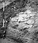 BB-72/3761
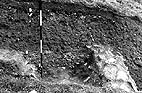 BB-72/3770
The 'rescarping' also calls for comment. The drawn section implies that the 'cut' into the spill of limestone blocks was in fact created at the time of the excavation of the ditch in front of the bank. This must, however, be questioned on two counts.
An important inference can be drawn from these observations concerning the destruction of the wall. Since the spill from the wall contained large limestone blocks amongst the mortar and rubble (shown clearly in photo 1 above), it is improbable that it resulted from a phase of robbing of the wall to obtain masonry for use elsewhere. It is more likely to have arisen from the deliberate destruction of the wall and the tipping of its remains down the front of the bank. That the large blocks in the upper part of layer ix still in situ (and shown in the photo reproduced here) did not roll or slide to the bottom of the slope implies that there were many more which did, and that this deposit originally comprised a thick layer of destruction material from the wall which indeed perhaps became thicker lower down the bank.
The conclusion that the wall was demolished in one operation seems to be supported by the rapid backfilling of the 'robber' trench, allowing the preservation of its back edge, and by the near total destruction of the wall in all places observed. This conclusion also seems to be supported by the two other records of the sighting of the wall. The first is the 'substantial rubble and mortar debris of a wall' found in 1951 on the crest of the bank in the south-west corner (ibid, 124). In a letter to Eric Gee of 15th Sept 1959 Ray Farrar refers to 'the debris of a ruined wall on top' of the bank being shown in a section in his possession (source: microfiche in NMR). On the eastern defences, the only other place where the added wall has been observed, the same rubble from a former wall was found in three places in the east bank, observed in around 1910, and described as 'a core of roughly piled blocks of Purbeck stone' (Drury 1930).
There is no independent evidence - ceramic or otherwise - which dates the wall. However, the same arguments applied to the stratigraphy at Cricklade also apply in the case of Wareham. If, as seems likely, the front of the bank at Wareham proved unstable fairly soon after its assumed construction in c. 879 (or earlier), it is possible to make two inferences: a) since the wall at the top of the bank is unlikely to have been built on unstable foundations, it would have been part of an arrangement which may well have also comprised another wall at the front; and b) the episode of the refurbishment of the defences, of which the wall on top of the bank was a part, may be assumed to have taken place not long after the construction of the primary bank.
The various phases in the history of the defences of Wareham can thus be interpreted in a precisely similar way to those shown by the defences of Cricklade:
Period 1. The construction of a primary bank, with or without a fronting palisade (late 9th century - though the western line of defences might be rather earlier).
Period 2. The construction of a stone wall added to the original bank - in the case of Wareham along its crest, but possibly also with another wall at its front (early 10th century).
Period 3. Deliberate destruction of the stone wall in order to slight the defences, rather than to acquire building stone for other purposes (c. 1016).
Period 4. Reconstruction of the defences with a new outer ditch on the west (landward) side (early 12th century), associated with the events of the 12th century civil war, and more particularly the reconstruction of the castle in the 1130s (Renn 1973; RCHME 1970, 333; Potter and Davis 1976, 95-6).
The defences of Christchurch, a fortress listed in the Burghal Hidage, have been excavated archaeologically on three of its sides (Jarvis 1983; Davies 1983). All trenches have shown evidence of a primary bank to the front of which a stone wall was added. The wall itself appears to have been destroyed nearly completely to its foundations, which contrasts with the presence in all the excavations of large amounts of stone from both the facing of the wall and the rubble from its core, scattered over the area of the berm and filling the ditches nearest the bank.
Jarvis comments that 'The essential feature of all the excavations of the defences is a rubble spread sealed by 13th-14th century layers. This seems to indicate that the defences were robbed in one large operation with the best stone being removed for use elsewhere' (Jarvis 1983, 19). Jarvis gives a date bracket of the 10th to 14th centuries for this episode.
However, the fact that the 'best stone' - i.e. ironstone blocks which were used for the front facing of the wall - were in a number of places not removed, but formed a high proportion of the material scattered on the berm, casts doubt on this interpretation. It raises the possibility that the defences were, as at Cricklade, systematically slighted in one operation by the destruction of the wall and the filling of the ditches with stones. To validate this hypothesis it is necessary to examine the interpretation of some of the published excavation results. (In the following paragraphs the trench numbers refer to those shown in Jarvis 1983.)
Site X1 (NW side)
The excavation showed the presence of the footings of a mortared wall, 1.4m in width, which was inserted into the front of the bank. The front was faced with ironstone blocks and the core built of heathstone. The bank itself consisted of a mixture of soil and decayed turf, probably without a fronting palisade, but possibly with a palisade at the crest. While the excavator (David Hill) argues that 'there would therefore have had to be a considerable period before the insertion of the wall for the bank to become stable enough to support it' (from Jarvis 1983, 23), it could, however, be more reasonably argued that a stone wall would have been required to strengthen and revet the unstable front of the bank after only a short time. In one place the wall foundation sealed a pit containing three sherds of pottery, described as being of 'Saxo-Norman type' (Jarvis 1983, 25-7). The excavator concludes that 'the original bank must date to before c. 919 as there is no doubt that the wall lies on the original Burghal Hidage circuit' (Jarvis 1983, 23). He goes on to suggest that the 'wall was inserted into a Saxon bank within the pre-Conquest period or soon afterwards'.
The spread of stones on the berm was clearly extensive - some 4m wide in most places and occupying the 25m length of the excavation. The excavator comments that 'As the 1970 excavation had not uncovered more than a small scatter of heathstone and fragments of ironstone, the wide spread of heathstone and occasional blocks of ironstone with much-decayed mortar [over this large area] ... was rather surprising' (Jarvis 1983, 25).
Hill goes on to suggest (in Jarvis 1983, 27) that the destruction of the wall is later than a 13th century barn built on the berm and the building of the Bargate. This dating is however dependent on the interpretation of F3 (Jarvis 1983, section 4, fig. 4), which is covered by the destruction deposits of the wall, as part of 'a possible medieval barn structure' of the 13th century. But there is no dating evidence given for this. Neither its structure nor its fill is described further, and there is no evidence that it is associated in plan with any post-holes or any features for which an interpretation as a barn is appropriate. And lastly, but certainly not least, it seems to be associated with a layer of packed 'chalk' (?mortar) (layer 8) which can best be interpreted as a layer either formed during the construction of the wall, or as an earlier layer put down to stabilise the berm before the wall's construction. This is covered by the small stones and mortar of layer 6, which seems to be associated with the construction of the wall. This in turn is overlaid by the destruction levels of the wall (layer 5) comprising some 1.3m of stone and rubble, which appear to give way horizontally to the stoney filling of the recut of the primary ditch. In short, the undated and enigmatic F3 belongs early in this sequence, and cannot therefore date the destruction deposits to later than the 13th century.
It is of interest to the interpretation of the sequence of the development of the defences that layers 8 and 6, the construction levels of the wall, seal the primary filling of the ditch. This is then recut and the spoil upcast rather later than 8 and 6, but earlier than its destruction levels. The ditch is then filled, apparently with the same material as comprises these destruction deposits.
Site X5, SW side
A trench in front of the former line of the wall (Jarvis 1983, 31) revealed a widespread 'tumble of stones' (f.8) associated with chalky and mortar layers (f.6 and 7). The tumble was composed mainly of large ironstone blocks, described as 'robbing debris'. However, since the evidence in trench XI shows that the ironstone was used for the facing of the wall, it is clear that it would have been the best stone available. This deposit is unlikely therefore to have originated from an episode of robbing. Sealed beneath the tumble of stones was a ditch, f.9. The section (Jarvis 1983, 30, fig.7) shows some of these same stones apparently partly filling the ditch.
Site X7, SW side
The excavations revealed a random spread of rubble, composed of ironstone, heathstone, large flints and some Greensand, lying 1-2 stones deep in the area to the front of the original wall (Jarvis 1983, 32). Stones apparently overlay the filling of a defensive ditch F6 (shown in fig. 8), already filled with silty sand, with several pieces of stone found in the fill. The excavator comments merely that 'the robbing of the material [of the wall] resulted in stone being pushed forwards on to the berm and ditch' (Jarvis 1983, 34).
Site X13 - W corner of the defences
Again on this site evidence was found of an extensive stone spread on the area of the inner berm. The excavator comments that 'the town defences were robbed of stone and levelled by the 13th-14th centuries. The robbing activity was similar to site XI where ironstone was preferred and removed whilst heathstone and some smaller pieces of ironstone were discarded in front of the wall' (Jarvis 1983, 49-50). This is, however, contradicted by the plan ( 1983, 50, fig.14), where a large area of ironstone blocks is recorded, some of which reached 0.5m in size. Again, this seems to indicate an episode of deliberate destruction of the wall rather than casual robbing of its best stones.
Site X4 - E defences
A trench here found 'substantial evidence of sandstone and ironstone rubble' (Davies 1983, 23).
Site W10 - E defences
Evidence was found (Davies 1983, 29) of an earth bank consisting of sand and gravel spreads on a brushwood base, with a ditch to its north-east. The ditch had apparently silted naturally over a short period. This was succeeded by phase IIa, in which the defensive line was refurbished by the addition of a stone revetment wall (1.15m in width in 1983, 30, fig. 6) to the front of the bank, with another ditch (120) apparently of the same phase excavated slightly forward to the line of the primary ditch. This latter ditch was filled with 'substantial rubble' from the wall after a period of silting. These are shown in the section (1983, 30, fig. 6) to have been large stones up to 0.4m in width filling the lower part of the ditch, which was not excavated. This ditch was recut at a later date.
The dating of these phases by the excavator (1983, 55) calls for some comment. The stone wall and the recut ditch are dated to the late 11th or early 12th century by extrapolation from the phasing, while the primary bank and ditch of the preceding phase are assigned to the 10th century on the basis that they must belong to a time after the Burghal Hidage list was drawn up - assumed here to be c. 919. This in turn follows from the assumption that since the Burghal Hidage assessment of 470 hides for Christchurch only covers defences on the south-west and north-west sides, the north-east side would have had none in the primary phase. The excavator comments (1983, 55) that the reasons for the addition of defences on the east side are not clear, but 'presumably reflect the inadequate nature of the initial work'.
This argument is, to say the least, highly tendentious. It is necessary to make two points: Firstly, it is clear from recent work that although there may in some cases be a remarkable correspondence between the figures in the Burghal Hidage and the actual length of the burghal defences on the ground, there are other cases (such as Lydford) where the known length of defences and the length shown by the hidage figures differ substantially (Brooks 1996, 130-2). No inferences or conclusions can therefore be drawn from these figures about either the existence or the non-existence of the defences in any particular place, or about the length of the defended circuit - although these figures can of course generate hypotheses about the location of a particular defensive circuit which can be tested archaeologically. Secondly, the uncertainties around the date of the Burghal Hidage, which should in my view be dated to c. 880 (Haslam forthcoming), necessitate caution in making inferences about using the date of c. 919 for the dating of defensive circuits of places included (or not included) in it. In short, there is no reason why the defences demonstrated on the north-east side of Christchurch should not be considered to be part of the Alfredian fortification of c. 878-9 (the date argued in Haslam forthcoming), with the stone wall, perhaps as elsewhere an addition to the bank to revet its unstable front, being built only a little while later. This view, however, contradicts Hill's analysis of the course of the defensive circuit (1996a, 198-9; 1996b, 85-6), in which the absence of Alfredian defences on the north-east side is assumed, for the same reason as that given by Davies (1983).
In effect, therefore, the hypothesis that no defences existed on the north-east side at Christchurch, generated by a particular interpretation of the Burghal Hidage assessment (Hill 1996a; Davies 1983) has been invalidated (or at least called into question), because bank and ditch defences appropriate to an Alfredian context have in fact been found on this side. Furthermore, this pattern is strengthened by the existence of the added stone wall, which (as shown below) is shown by every other Alfredian defensive circuit so far found archaeologically.
This particular trench also shows that at an even later date, but still probably in the pre-Conquest period, the wall, as elsewhere, was demolished and the defensive ditch filled with stones, with the inference that this destruction was not the result of an episode of casual robbing.
Conclusions
The evidence from the excavations on or near the defences at Christchurch
so far discussed is consistent with a sequence of development showing the same three phases as can be discerned at
Cricklade and Wareham:
a) The construction of a primary bank of earth and turves around three, possibly four, sides of a rectangular enclosure, possibly but by no means certainly with a fronting palisade, which there is no reason to believe is not of Alfredian date.
b) The replacement of the probably unstable front revetment of the bank by a mortar-bonded stone wall, its outer facing constructed of blocks of ironstone and its core of a mixture of various kinds of local stone and rubble. In several places this was associated with the re-excavation of the primary ditch, which had become at least partially silted, and at trench XI apparently deliberately filled to provide a level base to aid the construction of the wall. Given the presumed instability of the front of the bank, it can be inferred (as at Cricklade) that the wall was built only a few decades after the bank. This is consistent with a date for its construction in the later 9th century or the early 10th century.
c) The deliberate demolition of the wall around all the sides of the defences observed. Three observations combine to suggest that these deposits were not the products of robbing the wall for building material. In most places where the demolition products on the berm were observed, 1) they were spread with some force for a considerable distance beyond the wall over the area of the berm, 2) they included a large proportion of the good ironstone from the front face of the wall, and 3) after it had become nearly silted up the re-excavated ditch (of the wall-construction phase) was partly or completely filled with stones and rubble from this episode of demolition. It can be inferred from these facts that the defences were deliberately slighted at one time in an operation which was designed to destroy the defensive capability of the bank and ditch(es). The archaeological evidence is consistent with a date for this phase in the early 11th century (discussed below).
It is of some significance that in one place in trench XI the wall was found to overly a pit containing three sherds of pottery (above). Although these are described as 'Saxo-Norman', the arguments above would suggest that these sherds should rather be considered as being earlier in date than the late 9th or early 10th century.
The defences of the Saxon fortress have been excavated in several places by P.V. Addyman (1964; 1965; 1966; Saunders 1980, 149-53). On a section of the Saxon bank underneath the Norman fort on the west corner, a stone wall built of mortared granite blocks was shown to have been added to the front of a bank of earth. The published sections (Addyman 1966, 169, fig. 71) appear, however, to indicate an unstructured pile of large stones from the wall, some of them up to 0.5m in width, extending outwards from the former rear face of the wall for about 2m. Only one stone, described as a 'footing block', at the rear edge of the wall appears to have still been in position.
This provides an exact parallel to the situation at Cricklade, where in most instances it was only the rear footing stones which had not been removed. From the disorder of the other stones of the wall, and the fact that so many of those still remaining were of considerable size, it can be inferred that the wall was purposefully destroyed rather than casually robbed for building material.
Excavations on the site of the castle in the 1960s revealed the existence of defences of similar type to those at Wareham, with a primary bank capped with an added stone wall, its front truncated by a later cut (Brooks 1966). The published details are, however, insufficient to enable any meaningful parallels to be drawn with the other examples dicussed here, or to allow an independent assessment of the stratigraphy and/or phasing.
Another section recorded across the west defences (Durham et al. 1972) added little to this picture, and was too truncated to provide comparable evidence.
Alcock's excavations at South Cadbury have produced evidence of a phase of refurbishment of the defences of the former Iron Age and early Saxon fortress in the early 11th century. The association of this phase with the redefence of the whole circuit with a bank and stone wall, the rebuilding of the main gateway, the relocation of a mint and the beginnings of the construction of a church, suggest that this was designed to be more permanent than its common description as an 'emergency burh' would imply.
At the south-west entrance the excavation of a large area (site K) revealed the front walls of the defences of the late Saxon burh, as well as the side walls of a gatehall, both constructed of limestone slabs bonded with white mortar (Alcock 1969, 39). The same wall was also observed at site A on the inner rampart, and Alcock suggests that it completely encircled the hilltop (1995, 154ff.). Evidence of the massive destruction of the gatehall at Cadbury was shown by the fact that the entrance had been filled to a depth of 0.8m with rubble and powdered mortar. The stone wall was, furthermore, nowhere preserved to a height of more than three courses. In a comment on these observations, Alcock has stated that 'the Ethelredian gate had everywhere been deliberately reduced' (Alcock 1969, 39).
More recently, however, Alcock has reassessed his earlier interpretation (1995, 169-70), and suggested that the stones forming the gatehouse and the passage walls in the south-west entrance were not so much deliberately demolished as removed piecemeal by locals over an extended period. This would certainly explain the lack of large stones from recognisable destruction levels or tips, which can be demonstrated at Cricklade, Christchurch, Wareham and perhaps Lydford, as might be expected if demolition was carried out for its own sake. Furthermore, the survival to some degree of the perimeter walls suggests natural decay rather than deliberate demolition.
However, this picture is contradicted by Alcock's observation (1995, 170) that 'The final phase of Cadanburgh is represented archaeologically by phenomena which suggest that the interior had been deliberately tidied up before the burh was abandoned'. Buildings appear to have been removed, rubbish buried in pits and the site left empty on the removal and relocation of the last of the minters in 1020 - a process presumably involving the easy dismantling of the valuable timber-framed buildings (which could have been done as quickly as they were erected) and their removal to the lowland settlements. This 'tidying up' can, however, be seen as an exactly analogous process to the destruction of the walls at Cricklade and other places - viz, the need to eradicate the physical components of a place which would allow its easy occupation by a potentially hostile force. At Cricklade, where there had been a fortified settlement, only the settlement was left - which, incidentally, continued its minting activities (Haslam 1984a, 110); at Cadbury, the fortified settlement with its projected church and its houses was reduced to a bare hilltop which was 'returned to the agricultural activities which have continued up to the present day' (Alcock 1995, 170) - a situation which would any way have made the fortifications useless. Furthermore, the removal of the stonework of the gateway by later robbers - if such is the case - does not preclude its destruction as part of this process. In the 11th century the site could have been littered with the destruction deposits of the wall and gateway, only to have been removed at a later date for use as building material elsewhere.
The pre-Conquest defences - summary and conclusions
It is suggested here that the nature of, and the stratigraphical relationships between, the several features and layers associated with the construction and destruction of the pre-Conquest defences of all the places so far discussed are consistently explained by reference to an overall historical model. This is argued as providing both the necessary context for their construction and, just as importantly, an explanation in terms of historical processes for the stratigraphical relationships observed between them.
On present evidence there is no need to depart from the generally held view that the original defensive system was constructed in the later 9th century by King Alfred as a fortress which comprised one element in a system of similar fortresses which acted in the defence of Wessex against the Danes. It is argued, however, that it was constructed in the years 879-80 as a radical response to the presence of the two Viking armies lying in Cirencester and in Fulham during that period (Haslam forthcoming). After an interval of not more than a few decades at most, the turf revetment fronting the bank at Cricklade was replaced by a stone wall. This, together with similar features in the other fortresses in Wessex discussed above, is best interpreted as resulting from a systematic programme of the redefence of southern England carried out by Edward the Elder in the years around 904. After a period of neglect of the defences from c. 930 until c. 1000, in which the intra-mural walkway at Cricklade was obliterated and the ditches nearly silted up, the inner two ditches were recut as part of a probably rather piecemeal programme of the redefence of the fortresses of southern England by King Ethelred in the first decade of the 11th century. (The comparable evidence from Christchurch is somewhat ambiguous.) Very shortly after this the main elements in the defensive system of Cricklade, as well as of other fortresses in Wessex, were deliberately destroyed as part of a general policy on the part of King Cnut of safeguarding his position. The defences were again allowed to decay for over a century.
Period 1 | Period 2 | Period 3 | Periods 4-5
© Internet Archaeology
URL: http://intarch.ac.uk/journal/issue14/1/period3.htm
Last updated: Mon Jul 7 2003