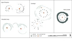
Figure 14: Plans of houses showing examples of wall gully, stake- and post-built, and stone structures (after Gibson 1999; Kelly 1988b; Lynch and Musson 2004; Williams 1998d).
There was a degree of architectural integrity in the structure of individual roundhouses considered by the project. While buildings are likely to have looked different, and the ways in which they were inhabited also varied, the basic 'footprint', from which all archaeological reconstructions are based, is in some respects generic. This clearly offers the rationale for the project, but equally it sets the challenge of resolving how the roundhouse remained an architectural form for more than three thousand years. The analysis set out in this section attempts to deal with these issues of variability and continuity.
The analysis draws from the data in the 'house table' of the project database. It adopts a biographical perspective, beginning with an assessment of the evidence for pre-house deposits and foundation deposits associated with the process of construction, then examining architecture, the use of space, and the role of houses in the landscape, to conclude with a review of the evidence for abandonment practices. The adoption of this approach respects the trend in a variety of recent studies of prehistoric houses in north-west Europe, which have emphasised the ways that architecture was socially and culturally constituted and was frequently conceptualised through the metaphor of a human lifecycle of birth, various rites of passage and finally death (e.g. Brück 1999; Gerritsen 1999).
Sites are rarely, if ever, characterised by a single, brief phase of occupation followed by abandonment. It is usual, instead, to find that places had histories of discontinuous inhabitation spanning one or more generations, centuries or even millennia. In this context, it is therefore unsurprising that buildings overlie earlier features and are subject to post-abandonment processes of destruction, decay and rebuilding.
Despite the developed historical sequences excavated at many sites, it remains less rather than more common for houses to be located directly upon earlier archaeological features. Of the 287 houses in the database, slightly over one-third (102) provided evidence for 'pre-house activity'; a quarter of these were rebuilds of another, earlier roundhouse and in four instances the houses were rebuilt more than once. This pre-house activity took the form of earlier roundhouses (not necessarily definite precursors) in 42 instances, indistinct occupation (for example post-holes and trenches) in 24 instances, pits and deposits in 19 instances, and hearths (6), rampart destruction (5), other structures (5), four-posters (4), lynchets and field boundaries (4), ramparts and enclosures (3), iron-working (2), agriculture (2), residual finds (1) and burial (1). The number of houses with earlier phases may be higher than indicated if indistinct occupation is in some cases the remains of poorly surviving earlier roundhouses.
There is only relatively limited evidence for foundation deposits or similar practices associated with marking the life history of the buildings. Given the widely acknowledged evidence from elsewhere in Britain, the lack of such deposits is likely to partly reflect the interpretative biases of the excavators. For instance, the broken soapstone ring found in a post-hole of building J1, Crawcwellt West, perhaps the 'hoard' of 70 slingstones in hut N at Walesland Rath or the three infant burials at house 7, Thornwell Farm, could be interpreted as marking foundation events. Saddle querns were also incorporated into buildings in what can be interpreted as structured ways: reused as a wall stone at Llwyn-du Bach, and inverted in the entrance to house R5, the Breiddin. Querns in particular may be treated in particular ways irrespective of the lifecycle of the building – found burnt with pounders in a hearth at Erw-wen, or in fragments within a later pit at Cefn Du (cf. Williams 2003). However to undertake full analysis of patterns involving structured artefact deposition associated with houses would require more detailed and critical scrutiny in the future, including a reassessment of available primary archives.
Figure 14: Plans of houses showing examples of wall gully, stake- and post-built, and stone structures (after Gibson 1999; Kelly 1988b; Lynch and Musson 2004; Williams 1998d).
The roundhouses recorded in the database were constructed by various different methods from a variety of materials (Figure 14). There are a few generalities that can be derived from an analysis of these data. Overall, the most common outer wall form found in Wales consisted of a wall gully, which would usually have contained upright posts or split timbers. Stone walls and clay walls seem to be favoured in the north, whereas post-built houses are more common in the south, and there is also a preference towards constructional forms represented by a wall gully in the south-west (Figure 15). It is possible therefore that there were geographical rather than chronological differences, and that the use of stone walls may not necessarily be indicative of a later date (Figure 16), with the caveat that there is a slight increase in the use of stone walls in the period AD 1 to 500 AD. However, what is striking is the general diversity of constructional forms throughout all periods.
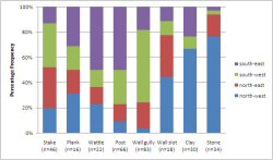
Figure 15: Bar chart showing the regional distribution of different elements used in the construction of houses. Moel y Gaer is excluded from this chart because the large number of post and stake built houses skews the results.
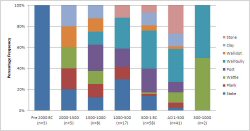
Figure 16: Bar chart showing the chronological distribution of different elements used in the construction of houses. Moel y Gaer is excluded from this chart because the large number of post and stake built houses skews the results.
It seems likely that the use of some materials, particularly turf, has been under-estimated owing to its poor survival below ground level. For instance, turf-walling has been suggested in a structural re-interpretation of houses at Moel y Gaer (Pope 2003), an interpretation that will soon be tested in a new reconstruction at St Fagans Museum of Welsh Life. In many other cases, all that survives of a house is its outer drainage gully, which might again point to the use of organic walling. This may also affect estimates of internal diameter; some excavators have estimated the internal diameter of a roundhouse on the assumption that the wall line is adjacent to the external drainage or drip gully, whereas in reality its location is more likely to be a disctance of c. 1m inside the gully.
The diversity of form extended to other aspects of house construction, such as internal diameter. There was a wide range in all periods, with a slight trend towards Bronze Age and Roman period houses being smaller, with exceptions in each case (Figure 17). The average floor area was 51m² which corresponds to an internal diameter of just over 8m. As may be expected, construction had a bearing on internal diameter, with stone houses smaller on average than those built from timber (Figure 18).
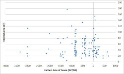
Figure 17: Scatter plot of internal area of roundhouses (m²) plotted against the earliest estimated or calibrated radiocarbon date from the house.
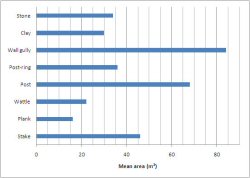
Figure 18: Average area (m²) shown for each of the main construction methods, having removed all the houses excavated at Moel y Gaer apart from one stake- and one post-built structure, which would otherwise significantly skew the results.
The prevalence of an eastern to southerly orientation of roundhouse entrances throughout Britain has been interpreted as evidence both for the practical concerns of early architecture which sought to maximise shelter and the amount of light reaching the interior of the building – and alternatively as following the dictates of a cosmological scheme structuring zoning of activities within the building. Treating the data from Wales in their rawest state, doorway orientation does seem to show a greater preference towards the east and south-east when compared to the orientation of settlement entrances (Figures 19 and 20). (Orientations were recorded to the nearest 22.5° (for example NNE), but were rounded up to the nearest 45° (for example NE) for the purposes of this analysis.) However, this is not an overwhelming preference, accounting for half of recorded entrance orientations only. Interestingly, there are also a number of west-facing doorways; these sometimes occur as opposing doorways in the case of houses with more than one entrance. In general, where both are known, entrance of site and house are more likely to face the same way than in different directions. Orientation of houses to face the settlement entrance occurs, for example, Dan-y-Coed and Collfryn, which were west-facing.
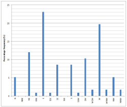
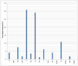
Figure 19 (left): Histogram displaying the percentage frequencies of entrance orientations of settlements (Settlements may be represented by more than one orientation in cases where there are multiple entrances).
Figure 20 (right): Histogram displaying the percentage frequencies of entrance orientations of houses.
The emphasis on an eastern or south-eastern orientation appears of less general significance when it is contextualised geographically and by chronological period, and when undetermined orientations are included. In this case, it is only in the Late Bronze Age and Early Iron Age that a south to east orientation is most clearly dominant (Figure 21). However, this pattern is principally the product of a few large hillfort excavations in which large numbers of buildings were excavated: Moel y Gaer, the Breiddin and Dinorben. If this bias is reduced by including only one house of each direction of orientation from each settlement, the pattern is more consistent (Figure 22), and the frequency of undetermined orientations presents a greater proportion of the data.
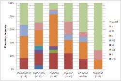
Figure 21: Histogram showing the frequency of roundhouse entrance orientations organised by 500-year period.
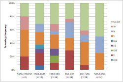
Figure 22: Histogram showing the frequency of roundhouse entrance orientations organised by 500-year period, and including only one house per orientation per settlement.
For the purposes of this article, a distinction is drawn between the architecture of the roundhouses and the features that accompanied activities within the buildings, such as hearths, pits, and artefacts. This division distinguishes between acts of construction and the daily patterns of inhabitation that made an immediate contribution to the roles played by the building. This serves as a useful analytical distinction for the purposes of organising and reviewing the data, but it enforces a dualism between the structure of spaces and the practices carried out by people and animals inhabiting those spaces.
Such theoretical principles are well meant, but they are of limited consequence in the case of the dataset assembled by this project. The primary limitation is that few, if any, of the excavated roundhouses had in situ floor deposits, and a smaller than expected proportion of the houses included internal structural features such as hearths, flooring and drains. Finds, too, were limited in number; there are 151 instances (53%) in which no recorded finds were associated with the building. Consequently, the following summary does not attempt the same scales of analysis employed for the chronological and architectural data.
Ninety-four houses were recorded as having hearths (33%). Eleven had a clearly associated external hearth (four of these came from houses with internal hearths also). Further details were provided for most of these, including information on positioning, hearth furniture (stake-holes and stone settings) and phasing. Sixteen houses were recorded as having evidence of internal partitions, 24 as having occupation deposits and 10 with wear. These low figures reflect the poor preservation of internal features on more recently excavated houses, as well as the difficulty of defining 'occupation deposits'. Further details were recorded for the floors of 53 houses. Internal drains were recorded in 41 houses, of which 32 houses were in the north-western region. Pits were recorded in 39 houses, post-holes (not part of an obvious post-ring) in 107 houses and stake-holes in 40 houses.
The spatial location of finds were rarely recorded in excavation reports; in general there was poor preservation of occupation deposits and finds tended to be in destruction layers or, more commonly, in post-occupation contexts. It would be unwise to assume in situ deposits except perhaps for objects set into floors for use. Apart from 'unknown' (objects recorded as being from the house but without known context, or unstratified objects) and 'various' (the design of the database did not allow for entry of more than one location for a find type), the most common location for a find type was in the outer wall (Figure 23). Where the object was found in a clearly associated external drainage gully this location was included in the 'outer wall' category – but only for this preliminary phase of analysis. It is becoming clear that deposition in wall contexts may not be accidental but instead associated with the placement of artefacts during house construction. Patterning was found around the periphery of structures, particularly in wall gullies and drainage ditches. Other common locations were hearths, doorways and ditch terminals. A peripheral location is slightly favoured over a central one. It may be of interest to note the positioning of objects associated with metalworking on the left side of the house only, but the numbers are too small to be significant (three instances).
Figure 23: A schematic summary of finds locations recorded in the database. The key refers to categories of material culture multiplied by the number of houses, and the value is therefore highest in spaces where a wide range of artefact types are found in a large number of houses; it does not reflect the quantities of individual artefacts recovered.
Environmental data were collected from 40 sites (an additional 5 records were created to store information from individual houses where particularly detailed information was available). Pollen was noted for 20 sites, 2 of which had off-site pollen only (this figure would probably increase if additional research was done into off-site pollen sources). Early and late landscapes could be characterised for 16 sites only, 10 of which were in the north-west area. Data on plant macrofossils were available for 34 sites (Table 1).
| barley | emmer | spelt | rye | oats | wheat sp. | bread wheat | pulses | flax | fruit | nuts | |
|---|---|---|---|---|---|---|---|---|---|---|---|
| no. settlements | 25 | 22 | 15 | 6 | 17 | 16 | 6 | 1 | 3 | 9 | 13 |
| earliest date of site | 2000 BC | 3520 BC | 900 BC | 900 BC | 1500 BC | 3520 BC | (3520) 400 BC | 300 BC | 1500 BC | 1500 BC | 3520 BC |
| latest date | 1000 AD | 1000 AD | 1000 AD | 500 AD | 800 AD | 400 AD | 600 AD | 300 AD | 400 AD | 800 AD | 400 AD |
Table 1: The frequency with which species of cultivated plants and the main categories of collected foods occur within the database, together with indication of the earliest and latest dates at which they appear
Emmer and spelt were sometimes hard to distinguish and may be combined as wheat species. The change from emmer to spelt which occurred in the Iron Age in other parts of Britain is known to be late in the region (emmer occurs late at Cefn Du, the Breiddin, Collfryn and Dinorben). Spelt was found in later phases at Holyhead Mountain, Llandysul, Woodside, Prestatyn and Dan-y-Coed; it appears to be more common in the Roman period.
Oats and sometimes barley were generally found as contaminants and in small quantities; it was not possible to tell if they were wild or cultivated for at least 13 of the sites. At Newton (Llanstadwell, Waterston), a Bronze Age site, hulled barley was observed, in contrast to naked barley only found at Stackpole, Meyllteyrn Uchaf and Glanfeinion (where it was the main crop, ready processed). Barley, bread wheat and oats appear in later contexts at Bryn Eryr, Melin y Plas, Upper Ninepence and Cefn Du (where flax is also found in the later, medieval phase only). At Collfryn, oats are from the medieval corn drier and flax from the Roman period. Pulses were found in the driers at St. Athan.
Plant macrofossil assemblages were generally small on these sites. The most common type of assemblage was crop processing waste (mentioned nine times as opposed to five instances of evidence for a stored crop). It appears that this was being used as fuel, which would explain the survival of charred remains in hearths (the presence of wild species such as bracken, gorse and arable weeds would also support this use). Charred cereal remains also seem to have been the result of drying or roasting in food preparation.
Evidence for wild species was collected from 24 sites. The recording and listing of these was variable. The most frequently occurring wild species were grasses (on 9 sites). Also relatively common were: heather, sloe, sedge, bracken, nettle, goosefoot, rush, hazelnut, legumes, docks, sorrel, plantains and arable weeds. Other 'useful' plants occurring with less frequency were chamomile, marigold, watercress, clover, elderberry, crab apple, prunus species, fat hen, rue, self-heal and unspecified herbs. This suggests the use of wild plants as bedding, fuel, fodder, roofing materials, foodstuffs and possibly medicinal use.
The available data for faunal remains were less good owing to poor conditions of preservation. Data were recovered from 16 sites. Only 5 sites had assemblages which were amenable to quantification of species (Biglis, Collfryn, Llandough, Whitton and Dinorben). On the 5 quantified sites, cattle were generally the most frequently represented species, followed closely by sheep/goat, then pig (with the exception of Llanmaes which had an unusually large pig assemblage, but work is still in progress here) and then horse. An unexpectedly high ratio of sheep/goat to cattle and pigs was noted at Biglis and Thornwell Farm, not typical of Roman sites. At Whitton, cattle were the greatest part of the assemblage by weight. There was however an unusual deposit in the (possibly later) well containing dog or fox, pig and deer. Wild mammals included badger, hedgehog and hare. Some spatial patterning was noted at Collfryn and St. Athan, where there was deposition of proportionally more sheep in the interior (Collfryn) and greater deposition towards the edges of the site (St. Athan).
| sheep/goat | cattle | pig | horse | dog | deer | wild mammal | bird | fish | shell-fish | |
|---|---|---|---|---|---|---|---|---|---|---|
| No. settlements | 15 | 15 | 12 | 11 | 8 | 10 | 6 | 6 | 1 | 3 |
Table 2: The frequency with which species of domesticated and wild animals appear in the bone assemblages documented within the database
The relationship between land use and the landscape context of settlements is difficult to judge from this dataset, principally because the environmental data from many of the sites are often poorly preserved and there is a crucial lack of recently excavated upland settlements. Nonetheless, using altitude as a very crude characterisation of landscape context, there is a relatively consistent pattern of sites with evidence for cereals situated at lower altitudes than those without (Figure 24). This impression is supported by pollen data, which shows that settlements with evidence for arable agriculture in the surrounding landscape are located at lower altitudes than sites producing no evidence for cereal pollen. This supports the idea that altitude has a bearing on land use and that dwellings were located in relation to arable and pasture. It may in turn be compared with George Smith's analysis of the hut circle settlements in Gwynedd, in which he noted a distinction in the modal altitudes of scattered settlement at 300-400m AOD and enclosed sites at 100-200m (Smith 1999, 37). He suggested that a degree of 'economic specialisation' may be one interpretation of this pattern.
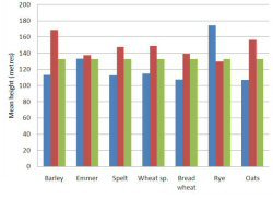
Figure 24: The mean altitude of settlements in which specified crops were and were not present, compared against the mean height of all settlements providing environmental information in the database.
The evidence for rebuilding and repair, and for replacement of sequences of houses demonstrates complex biographies for individual houses and sites. This evidence can be tied more closely to the dating evidence to estimate typical life-spans of these structures, and to relate this activity to patterns of site use and seasonality. Repairs and in situ rebuilding were recorded for each house, but where a house could be said to be rebuilt on a distinctly different alignment or after a period of disuse it was counted as a separate house (but with relationships to preceding and subsequent houses marked). In total, 30 houses (11%) were rebuilds of an earlier house (i.e. complete rebuilding in approximately the same location as an earlier house, with discontinuity of outer walling, doorway etc.). Eighty (28%) had been repaired at some stage; this includes minor repairs and more significant phasing, details of which have been recorded.
One-hundred-and-thirty houses (46%) were recorded as having post-house activity. In 48 instances this took the form of a later roundhouse. There were 16 instances of less distinct occupation (gullies, post-holes etc.), 15 of deposits of collapse or destruction material (in some cases burnt stone spread over the area), other structures (12), four-posters (12), midden material (10), walls or boundaries (8), pits and deposits (8), hearths (8), later finds including coin hoards (8), ramparts (5), burial monuments (4), robbing (4), iron-working (4), covering metalling (4), other later or post-medieval reuse (3), agricultural use (3) and one standing stone.
The review of the archaeological evidence presented above has drawn attention to some significant limitations in the currently available dataset, most notably in terms of artefact assemblages and the depositional histories from house interiors. It is also disappointing that there have been relatively few excavations of settlements in upland locations, given the stark distinctions that exist between upland and lowland in the Welsh landscape. These concerns aside, some broad observations do seem to be sustainable on the basis of the above analysis. From albeit a limited dataset, it appears that the siting of roundhouses on the location of earlier buildings was a rare rather than usual practice. The instances when this does happen are not chronologically defined nor are they found at similar types of settlements. This tallies with the evidence for rebuilding and repair of structures, which is also less common than might be expected if buildings were long-lived. It would be reasonable to infer from this that single generational structures were the norm throughout later prehistory and the Roman period in Wales. A useful contrast should be drawn between this and the evidence that settlements commonly present evidence of multiple 'phases' of occupation often spanning centuries.
The archaeologically recoverable footprints of buildings do not provide evidence for a widespread adherence to a specific model of house size or entrance orientation. This supports the arguments put forward by Pope (2007) and Webley (2007) contesting the universal applicability of a cosmological interpretation of roundhouse space. It is potentially more profitable to consider regional and local trends and patterns in their specific landscape context, for instance the prevalence of stone-built structures in north-west Wales.
© Internet Archaeology
URL: http://intarch.ac.uk/journal/issue23/1/3.html
Last updated: Mon Nov 26 2007