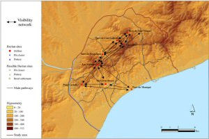
Figure 48: Visibility network between hillforts
Laietanian Iberian society is often thought of as remarkably hierarchical. Architectonic and landscape studies suggest that it was a highly structured society, with settlements developing to fulfil well-defined functions and led by elites whose power would have been based upon the control of economic resources (Asensio et al. 1998 and 2001; García et al. 2000; Olesti 2000; Zamora et al. 2001; Ruestes 2006).
One of the central aims of the current research is to explore these assumptions of structure and hierarchy through a careful study of the location of hillfort sites within the Laietanian landscape. In particular it seeks to assess the degree to which notions of hierarchy, structure and control are reflected in the ways in which the hillfort sites visually interacted both with the surrounding landscape and with each other.
It has been suggested that in the context of frequent warfare characterised by brief battles aimed at pillage (Quesada 1997, 662), hillforts would have served a primarily defensive function, with sites located so as to oversee (visually control) and notionally protect discrete areas of the landscape (Ruestes 2006).
To explore this, a cumulative viewshed was constructed for the entire set of hillforts (Figure 15) along with a Higuchi viewshed for each hillfort (Figure 14). These are crucial heuristics for studying the degree of visual control that such settlements might have had over the landscape. For example, the cumulative viewshed can serve to identify how well observed, or otherwise, a given area of the landscape actually was. In turn, Higuchi viewsheds enable notions such as 'visual control' and 'surveillance' to be further refined. By classifying the visible area in distance bands, they allow the identification of areas that were theoretically 'in view' but so distant as to make it virtually impossible for observers either to recognise activities taking place or to react effectively to them.
As can be seen from Figure 15, a great extent of the study area and the fertile valley lying at its north-west would have been within sight of the hillforts. The visual control of that landscape seems to have been distributed among two groups of hillforts (Figure 14). The inland areas were under the observation of the barrier of hillforts located in the inner mountains (i.e. Les Maleses, Turó de Penjabocs, Turó de Can Gallemí, Castellruf and Turó de Sant Miquel) and by Puig Castellar, at the inflexion point between the inner and coastal ranges of mountains. By contrast, littoral zones would have been visually dominated by the coastal hillforts (i.e. Turó d'en Boscà and Turó de Montgat) as well as by Puig Castellar and Les Maleses.
How visual control was carried out can be analysed in more detail:
On the one hand, individual hillforts would seem to have been responsible for visually controlling discrete portions of the landscape. As shown in Figure 15, several areas could have been overseen by a single settlement, usually with good levels of clarity (Figure 14). The central area of the coast, for example, as well as numerous stretches of pathways, are exclusively in view of Turó de Montgat.
In addition, a number of zones could have been within sight of two or more hillforts. However, as argued earlier, being theoretically able to see is very different from knowing what it is that you are looking at. As a result, although seen from different settlements, such zones could only have been effectively controlled by the closest one (Figures 14 and 15). For instance, Puig Castellar would have been the main hillfort responsible for reliable control of the central-western area, which includes a large stretch of the Besòs River. Although it can also be observed from Les Maleses, a visual distance over 3km would have made surveillance difficult and much more dependent on circumstances such as the clarity of the day, the observer, etc. Likewise, the tract of coast in front of the main hillfort of the territory i.e. Turó d'en Boscà, where two major pathways start, would have been primarily under the control of this hillfort despite also being seen by Puig Castellar, Les Maleses and Turó de Montgat.
On the other hand, it seems that areas of special importance must have been overseen by a number of hillforts (Figures 14 and 15). The inner stretch of the central corridor connecting valley and coast would have been controlled, at the effective visual distance of 1-3km, by the four mountain hillforts that flank this pass (i.e. Les Maleses, Turó de Penjabocs, Can Gallemí and Castellruf). The mouth of the Besòs River, crucial for communication and commercial purposes, and large expanses of the valley with agricultural resources are also overseen by four or five hillforts. However, successful surveillance of these areas, being over 3km away from the settlements, would not have been straightforward. Perhaps in an attempt to compensate for this, these zones are visually covered by many hillforts. In this respect, it could be particularly significant that the single portion of the valley within 3km of a hillfort is also the only area overseen by a sole settlement (Turó de Sant Miquel). Conversely, the north-west of the valley, being the more distant area with respect to the hillforts (over 6km), is within sight of the greatest number of them (i.e. six sites).
Finally, it can be noted that the south-east of the study area (which includes significant segments of pathways) seems to have been poorly overseen (Figure 15). One possible explanation for this is that documented hillforts located outside of the study area could have played a part in visually controlling that zone i.e. the edge effect problem with viewshed studies noted by van Leusen (1999, 218-19).
For this very same reason, conclusions regarding visibility, especially right at the margins of the study area, need to be considered with caution. Despite this it seems clear that while different hillforts would have primarily exerted visual control over exclusive portions of the landscape, overall visual control of the landscape would have been carried out collectively, with significant areas under the most intense levels of surveillance (as Gaffney et al. (1996) argued for the Neolithic landscapes of the Kilmartin area).
Comparing the Higuchi viewsheds for each hillfort (Figure 14) strongly suggests the existence of a visual communication network between them. Figure 48 synthesises the intervisibility relationships between hillforts, showing an overall network structured into two visibility sub-networks; one between the settlements on the mountains and the other between those on the coast, communicating exclusively through Les Maleses. The maximum visual distance between intervisible hillforts is 6km, making the network extremely effective for communicating through smoke or fire signals.
Figure 48: Visibility network between hillforts
With respect to the inland sub-network, the only two hillforts that are not intervisible are Penjabocs and Can Gallemí. However, Can Gallemí could still have been in visual communication with Penjabocs by using Castellruf as an intermediary. In fact, it has been suggested that Castellruf could have supplemented Can Gallemí (Gasull et al. 1995). Given the low visibility of Can Gallemí, Castellruf might have acted as its 'eyes'.
As regards the coastal visibility network, all of the hillforts would have had intervisibility relationships, with the exception of Turó de Boscà which does not appear to have been able to communicate directly with Turó d'en Montgat. Nevertheless it may have been possible to relay information indirectly via Les Maleses or Puig Castellar. This, however, needs to be considered with caution because the original height of Turó de Montgat hill was artificially modified during the 19th and 20th centuries and has been reconstructed here in order to calculate the relevant viewsheds.
The visibility network thus revealed does not appear to have given identical advantages to the entire set of hillforts. On the contrary, it seems that a hierarchical network was in place, centred upon Turó d'en Boscà. Firstly, located in the centre of the coastal visibility sub-network, it would have been the most integrated and protected hillfort not only of the littoral, but the entire study area, since it was placed within a belt of visual protection. Safeguarded towards the north by the barrier of hillforts standing on the top of the inner mountains, the coast could be directly controlled from Turó d'en Boscà as well as from other coastal centres. The circle of visual protection would have been completed by the field of view of Puig Castellar and Les Maleses towards the west and Turó de Sant Miquel and Turó de Mongat towards the east. This privileged position can be explained by the fact that Turó d'en Boscà would have been the dominant settlement of the study area, probably developing political and administrative functions and being inhabited by elites (García et al. 2000).
The goal of the visibility network would have been to achieve an effective communication between hillforts. Without excluding other uses, this would have been intended to facilitate the defence of the hillforts themselves and their access routes as well as agrarian resources. The high cost in time that must have been involved when walking from one hillfort to another in this mountainous area justifies the need for a visibility network that would have enabled signals about imminent dangers coming from inland or coastal areas to be communicated rapidly.
Thus, just before the arrival of the Romans, the Iberian hillforts appear to have displayed a highly structured level of social organisation concerning visual surveillance of the landscape.
Turó d'en Boscà would have been the centre of power in the study area, playing a pivotal role in visually controlling a number of key routeways through the landscape. A barrier of hillforts placed in the inner line of mountains would have served to protect this centre of power; the agrarian resources in the immediate valley; a territory's main artery i.e. the pathway along the ridge, and mountainous segments of corridors communicating between valley and coast. Penjabocs, Can Gallemí, Castellruf, and Les Maleses would have been responsible for visually controlling the central mountain pass. The crucial task of Les Maleses, however, appears to have been as a link between the visual networks on the inner mountains and on the coast.
The importance of Turó de Montgat was for the control and defence of the coast. Moreover, located by the sea and having natural pathways at both sides connecting the coast with the cereal crops of the inland valley, it is likely to have developed commercial functions. The purpose of the nearby pit cluster, only visible from this hillfort, could have been for storage of cereal surpluses coming from the inland valley and devoted to a possible maritime trade.
Two hillforts, Turó de Sant Miquel and Puig Castellar, would seem to have been key for controlling expanses of landscape east and west of the study area respectively, although, as outlined above, this could be due to archaeological edge effects. In addition, a number of hillforts would have been exclusively responsible for visually guarding given segments of the main pathways.
If the level of social organisation between hillforts was as significant as visibility analysis suggests, it seems rather unlikely that their location was based exclusively on the individual needs of every settlement (e.g. access to economic resources). Conversely, the apparent highly structured levels of social organisation, the hierarchy indicated by the visibility network, and the close chronology for the urbanisation on the hillforts at around the 4th century BC (Zamora et al. 2001, 214-21; Ruestes 2006, 230-31), point to the possibility that the spatial distribution of the hillforts reflects a deliberate and conscious design during that century.
© Internet Archaeology/Author(s) URL: http://intarch.ac.uk/journal/issue23/4/4.html
Last updated: Tues Mar 04 2008