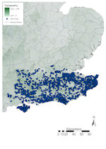
Figure 26: Distribution of finds in south-east England against topographic base map
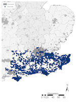
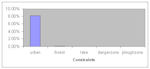
Figure 27: Distribution of finds in south-east England against constraints base map
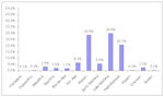
Figure 28: Chart showing PAS finds in south-east England by period
Figure 26: Distribution of finds in south-east England against topographic base map
Figure 27: Distribution of finds in south-east England against constraints base map
Figure 28: Chart showing PAS finds in south-east England by period
Topographically, south-eastern England is dominated by two areas of high ground (Fig. 26). The North and South Downs in Kent and Sussex rise to over 150m OD and divide the Thames Valley from the Weald and Hampshire Basin. The Rivers Medway and Great Stour both drain north-eastwards from Romney Marsh through the North Downs, and the South Downs are similarly punctured by several rivers draining southwards into the English Channel (from east to west, the Cuckmere, Ouse, Adur, Arun and Meon). Urbanism is a major landscape element, with Greater London and surrounding towns dominating the north, and much of the entire coastal zone in the region is urbanised. There are few extensively wooded areas and little lakeland. Danger zones are restricted to military areas outside Farnborough (Fig. 27).
A total of 25,245 finds have been reported in south-east England, accounting for 20.7% of the national assemblage (Fig. 7). Of these, Greater London and Surrey, the most heavily urbanised areas, only account for 15.9% (4004 records) of finds, whereas Kent and East Sussex make up 43.5% (10,984 records) and West Sussex, Hampshire, the Isle of Wight and West Berkshire 40.6% (10,257 records). This highlights the gaps in the distribution seen in and around Greater London (Fig. 26). A breakdown of the assemblage by period (Fig. 28) shows the prevalence of Roman and Late Medieval records, with Post-medieval also well represented. These account for 79.1% (19,972 records) of the assemblage. Prehistoric material accounts for 13.1% (3271 records), by far the highest in England, and Early Medieval 5.4% (1357 records), modern and foreign material 0.4% (102 records) and undated material 2.2% (543 records).
The distribution of finds in south-east England (Fig. 26) clusters in four discrete areas: western Kent, either side of the North Downs, eastern Kent, the coastal zone of East and West Sussex below the South Downs, and the Winchester area. Few finds have been made on the higher ground of the North or South Downs or in the Weald. The kernel density plot (Fig. 5) shows the main concentration of finds in Kent, an original PAS recording area, and in the Brighton and Bognor Regis regions, which is reflected in the quantification above. With the exception of a line of finds from along the Thames foreshore, no doubt caused by active detecting, Greater London is virtually blank.
Otherwise there is little correlation between the pattern of finds recovered and rivers, with the exception of the Great Stour and Little Stour in eastern Kent. Although finds have been made within the vicinity of the rivers in East and West Sussex this does not seem to be as visible as in East Anglia. Roman roads provide similar results, with no strong correlation seen, except on the roads radiating out from Canterbury where they provide significant foci for finds recovery. Alongside these, the ancient routeways of the North Downs Way and South Downs Way in Kent and Sussex respectively also provide relatively large numbers of finds. However, the effect of the modern road network in south-eastern England is striking, especially in relation to Greater London and Kent. Here the lines of the M25, M2/A2 and M20/A20 become clearly visible simply from the patterns of finds, and across the region there is also a general correlation with modern A-roads, no doubt reflecting the large numbers of detectorists travelling out from the urban areas of Greater London and its environs.
The potential constraints on the data make a visible impact (Fig. 27). A total of 2074 finds (8.2%) were made within areas where constraints on recovery were calculated (Fig. 29), virtually all in urban areas (2055 records, 8.14%), which, although above the national average is unsurprising given the levels of urbanism. Of note, however, is the correlation between urban areas and clusters of finds around them and near major roads, indicating that much detecting is undertaken near these urban areas. Greater London and its environs both west and east limit recovery significantly, with a dearth of finds reported. Elsewhere urban areas again constrain data recovery, including the Maidstone area, Royal Tunbridge Wells, Canterbury, Herne Bay, Margate, Ashford, Dover and Folkestone in Kent; and the Sussex coastline.
In other parts of south-east England, constraints on data collection are low, with ploughzone across the whole region, little forest, lakeland or danger zones. The sparse distribution across the Weald cannot, therefore, be explained by factors constraining recovery and must represent the impact of the ancient Wealden Forest.
South-East England provides real challenges in the assessment of finds recovery. The area is obviously greatly affected by Greater London and its surrounding urbanised zone in Surrey and Kent. As a result, the distribution density of finds seen (Figs 26 and 27) must be used only with extreme care. In the vicinity of Greater London, this is highly constrained by modern settlement and the road network pushes this influence further east, well into Kent. Away from the immediate influence of London, especially in eastern Kent and southern Sussex, a very different pattern emerges, more akin to that seen elsewhere in the country, with many finds coinciding with rivers, Roman roads and prehistoric routeways rather than the modern road system.
The breakdown of the region's assemblage by period follows the national trend, although Iron Age finds are proportionally higher and, perhaps surprisingly, Roman period finds lower than adjacent regions (Sections 2.4.2.3, 2.4.2.4 and 2.4.2.6). The former likely reflects the region's importance, by the Late Iron Age at least, in cross-Channel relations and trade (Darvill 1987, 166-71). The lower levels of Roman material may be associated with the concentration of villa settlements on the coastal plains of Kent and Sussex, and comparatively few higher status settlements on the chalk downland (Hingley 1989, 133-7).
© Internet Archaeology/Author(s)
URL: http://intarch.ac.uk/journal/issue25/2/2.4.2.5.html
Last updated: Tues Apr 21 2009