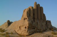
Figure 35: Byash Barmak Köshk (also known as the 'Organ Köshk' or 'Five Finger Köshk').
There is a very clear line of disjuncture through the western area of the town, lying at a slight angle to the majority of the streets (Fig. 34 - opens GIS). It is suggested here that this marks an earlier boundary to the city, somewhere between its 8th-century inception and when the 11th-century town walls were constructed.
Figure 35: Byash Barmak Köshk (also known as the 'Organ Köshk' or 'Five Finger Köshk').
It is interesting that the only köshk within the walled city (Fig. 35) lies to the west of this putative boundary: if these were conceived as extra-mural elite residences, then perhaps its original location was indeed outside the town, only to be later encompassed when the 11th-century walls were constructed. It is not clear what the nature of the town boundary was at this time; although perhaps not walled it was certainly delineated/marked with a sufficient barrier to cause roads to cross it at nodal points (gates).
It might also be suggested that a similar boundary lay somewhere to the east, given the preponderance of open spaces in this area. What is also evident is that the main east-west street exerted a considerable pull over the development of the built space, with densely packed buildings extending further out in these areas (Fig. 36 - opens GIS).

© Internet Archaeology/Author(s) URL: http://intarch.ac.uk/journal/issue25/1/8_2.html
Last updated: Mon Sept 29 2008