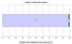
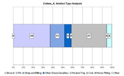
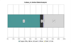
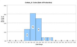
Fingerprint charts for i) artefact date analysis, ii) artefact type analysis, iii) artefact metal analysis and iv) coins – date of production


Reference: Richards and Haldenby in prep.
The site at Cottam A is located about 1km south/south-east of Cottam B, to which it is connected by an ancient north-south trackway that has been observed as a crop-mark running alongside one arm of a fluvio-glacial valley. From here the trackway appears to continue to the south-east and to head in the direction of the preserved earthworks of the deserted medieval village of Cottam. In Domesday Cottam is listed as Cottun, from the Old English Cotum, the dative plural of cote, meaning 'at the cottages'.
Cottam A comprises crop-mark enclosures of a Romano-British ladder settlement, which sits astride the trackway. However, metal-detecting over several years has revealed Middle and Late Saxon finds. The VASLE dataset has been compiled by Dave Haldenby from the excavated and metal-detected finds.
Modest site size coupled with a shorter span of use appear to have contributed to there being only around a third of the numbers of both pins and strap-ends found on the Middle Saxon area at Cottam B. However, the fact that few recognisably Anglo-Saxon features were found during excavations in 1995 is in keeping with this lower number of finds and may argue for Cottam A having a separate function, possibly involving animal husbandry and not permanent settlement.
Fingerprint charts for i) artefact date analysis, ii) artefact type analysis, iii) artefact metal analysis and iv) coins – date of production


© Internet Archaeology/Author(s)
URL: http://intarch.ac.uk/journal/issue25/2/4.4.17.html
Last updated: Tues Apr 21 2009