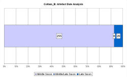
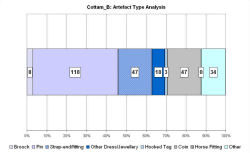
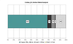
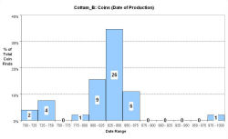
Fingerprint charts for i) artefact date analysis, ii) artefact type analysis, iii) artefact metal analysis and iv) coins – date of production


References: Haldenby 1990; Haldenby 1992; Haldenby 1994
Richards 1999b; Richards 2001; Richards 2003
Archives:
doi:10.5284/1000339
http://ads.ahds.ac.uk/catalogue/search/fr.cfm?rcn=EHNMR-1063686
The site at Cottam B is situated high on the Wolds, c. 20km from the coast. The site sits at the top of one arm of a dry valley and an Iron Age trackway runs north-south through the site and connects it to the site at Cottam A.
The site has undergone intensive metal-detecting over several years (Haldenby 1990; 1992; 1994). The VASLE dataset has been compiled by Dave Haldenby from the metal-detected and excavated finds. Aerial photography and geophysics have revealed the presence of a 'Butterwick-type' enclosure. Excavations in 1993 yielded a range of Middle Saxon finds and traces of three timber buildings and associated gullies/pits. Excavations in 1995, 100m to the north, produced sub-rectangular enclosures, with evidence for a substantial bank and ditch and gateway structure, with post-built structures in the interior. The finds from this area were no earlier than the 10th century.
Richards (1999b) has argued that the Middle Saxon site was a small farming settlement, possibly under the control of the villa regalis at Driffield. Disruption in the late 9th century caused abandonment of the earlier site and its relocation to the north, under Anglo-Scandinavian lords.
Fingerprint charts for i) artefact date analysis, ii) artefact type analysis, iii) artefact metal analysis and iv) coins – date of production


© Internet Archaeology/Author(s)
URL: http://intarch.ac.uk/journal/issue25/2/4.4.18.html
Last updated: Tues Apr 21 2009