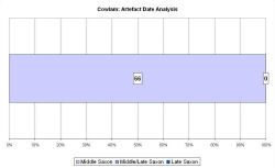
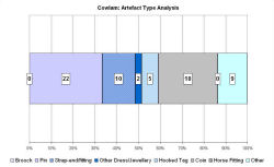
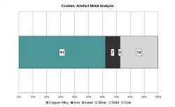
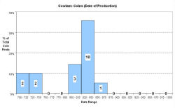
Fingerprint charts for i) artefact date analysis, ii) artefact type analysis, iii) artefact metal analysis and iv) coins – date of production
Reference: Richards and Haldenby in prep.
Archives:
http://ads.ahds.ac.uk/catalogue/search/fr.cfm?rcn=EHNMR-630094
http://ads.ahds.ac.uk/catalogue/search/fr.cfm?rcn=EHNMR-1444348
Cowlam lies high in the Yorkshire Wolds, around 20km from the coast. The sites of Cottam A and Cottam B lie a little to the east. A major route-way, known as the High Street, runs along the northern edge of the Cowlam township. It follows the line of an earlier road, visible immediately to the south of the modern road as a soil mark, which has long been recognised as a Roman road linking Sledmere in the west with Rudston and Bridlington in the east. The line of Neolithic and Bronze Age barrows along the road suggest that it may have originated as a prehistoric trackway. A second road, known as the Driffield Road, runs north/north-west–south/south-east from West Heslerton down to Driffield, effectively bisecting the township. The remains of the village of Cowlam lie immediately to the east of this road.
The medieval settlement and church is recorded in Domesday, although the earthworks of the deserted medieval village were ploughed out in 1972. The chapel of St Mary survives as a small chapel rebuilt on the site of the old church. It contains a large tub-shaped Norman font with arcaded figures.
Metal-detecting has revealed Middle Saxon finds at the head of Cowlam Well Dale, to the south-east of the medieval village. Excavations in 2002-3 revealed a number of gullies and structures, including an SFB. The VASLE dataset has been compiled by Dave Haldenby from metal-detected and excavated finds, and is complete to 2007.
Fingerprint charts for i) artefact date analysis, ii) artefact type analysis, iii) artefact metal analysis and iv) coins – date of production
© Internet Archaeology/Author(s)
URL: http://intarch.ac.uk/journal/issue25/2/4.4.19.html
Last updated: Tues Apr 21 2009