Following the start of a large-scale geophysical survey programme in Heslerton during 2000, funded by English Heritage Archaeology Commissions, it was felt that there was a need for a small-scale excavation programme to clarify the nature of some of the features emerging in the surveyed areas and to identify the level of preservation of the buried archaeology and assess the risk to these deposits from agriculture. It was also felt that a small-scale excavation programme would be the ideal setting to evaluate a variety of different digital recording methods.
Handheld computers and digital recording have been a feature of the fieldwork undertaken in Heslerton since 1984. However, new handheld recording devices such as the Personal Digital Assistant (PDA), using off-the-shelf software, offered a new and powerful alternative to the various devices used in Heslerton over the previous 16 years, each of which had required dedicated software to be written. New technologies including greatly enhanced Total Stations, Global Positioning Systems and high-resolution digital cameras had either become available or radically improved since large-scale excavations concluded in Heslerton at the end of 1995 (Powlesland 1987; Powlesland 1997; Haughton and Powlesland 1999).
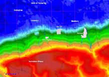
Figure 1: Map showing the location of HPP Site 28, between the modern villages of East Heslerton and Sherburn, the parish boundaries and a colourised surface model showing the extent of the ancient wetland area in blue, the shallow slope from the foot of the Wolds in green, the Wolds scarp in orange/yellow and the Wolds in red (compiled using elevation data from NextMap).
It had initially been planned to evaluate a number of sites associated with a linear wetland-edge settlement or 'ladder settlement', which was first identified from the air during the 1970s, following the 28m contour on the southern side of the Vale of Pickering. The geophysical surveys then in progress were radically changing our perception of this settlement and the scale and density of the archaeology in the area. However, the large-scale outbreak of foot-and-mouth disease during the winter and spring of 2000/2001 meant that access to land was severely restricted and preparation for excavation had to await clearance from the local foot-and-mouth inspector. The original proposal to excavate three areas in different fields over different parts of the 'ladder settlement' had to be abandoned in favour of a single field on a farm with no stock, which could be accessed without crossing any land that had recently supported stock. We are grateful to the Cussons family for giving us free access to their land, and to Rolawn, the turf contractor to whom the field had been let. Without free access to areas that had been harvested, the choice of areas for excavation was constrained to areas that could be examined with the minimum interference to the active farming programme. Fortunately, the site selected, Heslerton Parish Project (HPP) Site 28, fitted the restrictions imposed as a consequence of foot-and-mouth and had a high density of geophysical anomalies that satisfied the project research objectives, and was conveniently located adjacent to a farm access track (Fig. 1). We are grateful to English Heritage for supporting and funding the excavation and the production of this article.