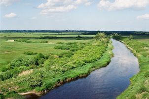
Figure 21: River Kloostri with levees and flood basins in Estonia. Photo L.I. Kooistra.
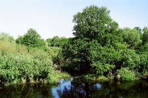
Figure 22: Woodland on a levee of the River Prypjat in Belarus. Photo L.I. Kooistra.
West of the settlements in Tiel-Passewaaij flowed a small river called the Linge. The southern levees of the Linge seem to have been occupied less intensively in the Roman period than the streamridge on which the settlements of Tiel-Passewaaij were located (Vossen 2007; Fig. 4). Historical sources indicate that the River Waal, which nowadays flows to the east of the settlements, was already active during the Roman period (Tacitus Annales 2, 6, 4; Tacitus Historiae 5, 19). Soil survey research in the Dutch River Area suggests that the levees of rivers that were active in the Roman period were not inhabited as intensively as older streamridges. It is not entirely clear, however, whether the actively meandering rivers have washed away settlements during the Roman period and Early Middle Ages and whether information has thus been lost. It is certain that settlements have been lost during floods. For example, as yet no remains of the Roman fort near Wijk bij Duurstede have been found, while the large amounts of Roman pottery in river sediments at this location show that there was a fort at the branching of the Rivers Rhine and Lek (van Es 1994, 50, 52).
The main difference between a levee and a streamridges is that levees are always part of an active river, and thus have a higher risk of flooding. Due to the dynamics of the rivers, less is known about the use of levees. It is, however, likely that levees were exploited in the same way as streamridges. If the levees south of the River Linge were inhabited less intensively, remnants of riverine woodland may still have been found here (Figs. 21 and 22). On the low parts of the levees and on the convex banks of rivers, this woodland consisted of willow (Salix). Alder (Alnus) cannot tolerate the strongly fluctuating water levels of an active river, and is found in locations where water levels fluctuate less, such as in the flood basins. A mixed woodland, including ash (Fraxinus excelsior), elm (Ulmus), field maple (Acer campestre) and oak (Quercus) may have grown on the higher and drier parts of the levees (van Beurden 2008).
Figure 21: River Kloostri with levees and flood basins in Estonia. Photo L.I. Kooistra.
Figure 22: Woodland on a levee of the River Prypjat in Belarus. Photo L.I. Kooistra.
Woodland on levees may have been used communally. This means that it did not belong to a specific settlement's territory. In that case, the absence of ownership claims that is assumed for the flood basins also applied to the forested parts of levees. Timber from the woodland on the levees of the Linge could be used for construction and fuel in the settlements of Tiel-Passewaaij. Livestock may have grazed in the woods, but the organic remains have not revealed any evidence for this. A third use of the forested levees is as hunting grounds. The game animals found in the settlements probably lived in the woodland on the levees. As on the streamridge, the inhabitants of Tiel could have collected vegetables, herbs, fruits and hazelnuts from the levee. The levees of the Linge were probably not used for growing crops by the inhabitants of Tiel-Passewaaij. That does not mean that there were no arable fields on the levees of the Linge, but they belonged to other settlement territories.
It is assumed that the levees of the Linge were mainly exploited to obtain hard wood such as ash, elm, field maple and oak. If such a woodland existed, it may have been used to put livestock to pasture or for hunting. It is unlikely that the inhabitants of Tiel-Passewaaij had arable fields on the levees of the Linge.
© Internet Archaeology/Author(s)
URL: http://intarch.ac.uk/journal/issue27/5/3.1.3.html
Last updated: Tue Nov 10 2009