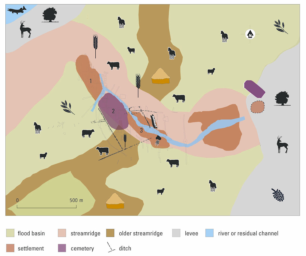
Streamridges are former river beds together with former levees. In a river area with a soft substratum and a slight drop in height, the streamridges and the levees of active rivers form the highest parts of the landscape. Because they are located some distance from the active stream of the river and are surrounded by the lower flood basins, these highest parts of the landscape seldom flood. Most of the streamridges in the Dutch River Area have relatively fertile soils.
The vegetation development and land use is similar for streamridges and levees. When streamridges and levees of an active river system are not used by man, mixed deciduous woodland develops. The composition of the woodland depends on the frequency of flooding (van Beurden 2008, 6-8). Palynological research (Steenbeek et al. 1990; Kooistra 1996, 49-50; van Haaster 2004), including that in Geldermalsen-Hondsgemet (Kooistra 2009), demonstrates that most of the streamridges in the Dutch River Area were already largely deforested in the Iron Age. The general idea is that this deforestation was caused by human activities.
Streamridges are suitable for habitation because of their relatively high location and low frequency of flooding. That streamridges were in fact used for habitation is established by surveys carried out in the Dutch River Area (Willems 1986; Kooistra 1996, 50-55; Vossen 2007; Vossen in prep.). The numerous excavations in the Dutch River Area confirm the results of the soil surveys.
Although no actual vegetable gardens have been found so far, these must have been located within the settlements on the streamridge. Evidence for the presence of vegetable gardens consists of seeds of vegetables such as beet (Beta vulgaris) and kitchen herbs such as coriander (Coriandrum sativum).
Botanical research in the Dutch River Area has shown that the streamridges were largely in use as arable land (Fig. 17). This is indicated by the weeds assemblage found among the cereals. This consists of wild plants of dry to humid, moderately fertile soils. Species of humid to wet conditions and grassland plants have also been found among the arable weeds. All these plants have a preference for moderately heavy to light clay soils. Weeds of heavy clay soils, which grow in the flood basins, have not been found among the cereals. Therefore, it is believed that in the Roman period, the arable fields were located on the streamridges, and that these fields contained wet patches.
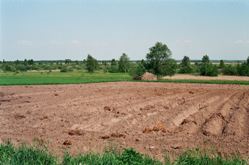
Figure 17: Transition from streamridge to flood basin of the River Narew in Poland. Photo L.I. Kooistra.
On the arable fields in Tiel-Passewaaij, cereals such as hulled six-row barley (Hordeum vulgare var. vulgare), emmer wheat (Triticum dicoccon), oat (Avena sativa) and millet (Panicum miliaceum) were grown. Other crops that were probably cultivated here are pulses, flax and oil-bearing seeds, although these crops can also be grown in vegetable gardens.
Botanical research in Houten-Tiellandt – the combination of species found together in one sample – suggests that cereals were grown using a rotation system with fallow years (Kooistra 1996, 320-22). What the rotation system was like is still unknown. The simplest system is two-course rotation where cereals are grown one year followed by a fallow year. Research on insects indicates that in Houten-Tiellandt, livestock was put to pasture on the stubble left after the harvest in July-August (Kooistra 1996, 326-29). Cattle, sheep and horses could also have grazed on fallow land, where they ate arable weeds and crops growing from the previous year's seed. This had two advantages: livestock was fed and the fields were fertilised.
Indications for dry pasture on the streamridges and the levees are scarce, which is why the area of pasture on streamridges is believed to have been small if not non-existent. It was probably just the fallow fields that served as pasture. In a two-course rotation system, this comprises a sizeable area.
A last possible use for the streamridge is for the acquisition of wood for building and fuel. Palynological research shows that the tree density on streamridges was low. Nevertheless, tree species such as oak and hazel, which indicate remnants of wood on dry grounds such as streamridges, have been found in the construction of buildings. However, these trees are outnumbered by the proportion of tree species from wet grounds. Trees on the streamridge probably grew as single trees rather than woodland. Some of the vegetables and herbs that were consumed were collected from the natural vegetation of the streamridges. Hazelnuts and fruits such as blackberries and elderberries may have been gathered in late summer from bushes growing on the streamridge. Loam for building walls could be dug from the soil of the streamridge.
The streamridge of Tiel-Passewaaij comprised an area of c. 33 hectares. The settlements and the cemetery were located on the southern flanks. Vegetable gardens were located inside the settlement. The rest of the streamridge was in use as arable land. A proportion of the fields was left fallow and was used as pasture during this period. The streamridge contributed little to the production of wood.
© Internet Archaeology/Author(s)
URL: http://intarch.ac.uk/journal/issue27/5/3.1.1.html
Last updated: Tue Nov 10 2009