Figure 24: Fishing equipment in the flood basin of the River Prypjat in Belarus. Photo L.I. Kooistra
The settlements and cemetery of Tiel-Passewaaij were located south of a residual channel. Only in the settlement Passewaaijse Hogeweg were one or more houses situated on the northern side of the channel (Heeren 2007, 49; Heeren 2009). The residual channel carried water in the Late Iron Age, when the current ran from east to west. In the mid-1st century AD, the residual channel silted up. From the time when the channel formed a marshy depression on the streamridges, the farmhouses were no longer orientated on the channel; also, wells were now dug for drinking water (Heeren 2009, 57, 59-60). The first use of the cemetery also dated to the period when the channel rapidly began to silt up. A hundred years later, in the middle of the 2nd century, the western part of the residual channel was reactivated, not from the south-east but from the north-west. A breakthrough of the River Linge is the most likely cause. The northern settlement was abandoned around this time; the lower parts of the cemetery flooded. A new channel branch to the north-west of the cemetery ended in the western part of the flood basin (Heeren 2009, 67). Since the inhabitants used wells for drinking water, the eastern part of the residual channel probably remained a marshy depression.
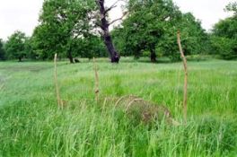
In the first half of the 1st century, when the channel still carried water, it supplied the settlement with drinking water. For a period of around a hundred years, the channel was dry, and because it was probably a marshy depression, it was used for grazing livestock. From AD 150, the western part of the channel carried water again, causing the abandonment of the settlement Oude Tielseweg. It is unlikely that the channel was used for drinking water in the Middle Roman period, although it may have been used to water livestock. Evidence for the watering of livestock in a residual channel in Geldermalsen-Hondsgemet consists of hoofprints of cattle found on the muddy banks of the channel (van Renswoude 2009, 90).The residual channel in Tiel may also have been used for fishing (Fig. 24).
Figure 24: Fishing equipment in the flood basin of the River Prypjat in Belarus. Photo L.I. Kooistra
© Internet Archaeology/Author(s)
URL: http://intarch.ac.uk/journal/issue27/5/3.1.5.html
Last updated: Tue Nov 10 2009