Figure 34: Clickable map of S. Omobono showing the excavated trenches (after original in AFSRCM). [View static image]
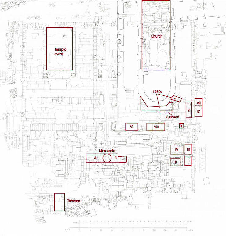
This section provides a basic outline of the major fieldwork efforts relating to the site of S. Omobono since its discovery. For the sake of clarity and precision, the information concerning the fieldwork is presented chronologically according to decade; the location of the corresponding trenches is indicated in Figure 34.
Figure 34: Clickable map of S. Omobono showing the excavated trenches (after original in AFSRCM). [View static image]
Following the demolition of much of the surrounding area in 1937, the archaeological importance of the site was immediately understood and quickly disseminated by Colini (1938b, 279-82; 1940b, 75-6; some of the finds are also recorded in Colini's notes, quaderni V and VII; Colini 2000, 28, 78, 82, 84, 87, 89, 90, 97-107, 114, 143, 158, 164, 172, 173, 192, 250, 251, tables V and VI). The work, as in adjacent areas of the city, resulted in the destruction of significant portions of the archaeological stratigraphy. The surviving deposits were preserved only thanks to the efforts of Colini, who was the first to identify the cult structures as the Temples of Fortuna and Mater Matuta. Excavation work around the apse of the church of S. Omobono to reinforce its foundation brought to light the first fragments of architectural decoration from the Archaic temple as well as numerous other artefacts (Figure 34, area marked '1930s').
A new program of excavation, this time directed at the study of the earliest stratigraphy (below the pavement levels previously reached by Colini), was carried out between February and May of 1959. The fieldwork, directed by Ejnar Gjerstad outside the apse of the church of S. Omobono, included the first true stratigraphic excavation at the site. The sounding was located near the earlier excavation by Colini in the eastern portion of the area and was intended to provide better data for the earliest phases of the site (Figure 34, area marked 'Gjerstad'; Gjerstad 1960, 378-426; 1962, 33-103).
Investigation of the area was resumed in 1961-1962 near the 'donario circolare' (the round altar visible in Figures 73 and 74) with an excavation directed by Liliana Mercando. It was through this work that the various fragments of the donario were discovered and restored. In order to bring to light the lower pavement of thicker slabs, several tracts of the pavement of thin tufo slabs were removed. The excavation area, the limits of which can be hypothetically identified as coinciding with the western altar on the west and a few metres from the eastern altar on the east, was divided into three sections (Figure 34, area marked 'Mercando A and B'; Mercando 1966, 35-67).
In 1962, a sounding was conducted in the south-western portion of the area, within a Republican structure whose function, despite its initial identification as a taberna, remains to be clarified (Figure 34, area marked 'Taberna'). The years 1962-1964 saw the excavation of settori II and IV, located in the eastern portion of the podium of the twin temples (Figure 34, 'II' and 'IV'). Settore V, within the eastern side of the podium, and VI, in the area in front of the eastern temple, were also excavated in 1964 (Figure 34, 'V' and 'VI').
The investigation of the so-called taberna continued in 1968 and 1969 (Ramieri 2011, 1154-60). Almost at the same time (1967-1969), Giuseppina Pisani Sartorio began the first excavations of the interior and exterior of the cella of the western temple (Figure 34, 'Tempio ovest').
In October 1973, the construction of tanks for the heating system of the building of the V Ripartizione necessitated investigation of the stratigraphy of an Imperial taberna on the south-eastern limit of the area, through a sounding (off map; Virgili 1980, 7-17). In 1974 and 1976, settore I, next to settori II and IV, was excavated (Figure 34, area marked 'I'). In 1976, settore III was cleaned but not excavated (Figure 34, 'III'). Also in 1976, settore VIII, located in the area in front of the eastern temple, a few metres from settore VI, was opened (Figure 34, 'VI'). Settore VII, immediately outside the eastern wall of the podium, was opened in 1977 (Figure 34, 'VII'). Settore IX was excavated together with settore VII in 1978, and the two were combined (Figure 34, 'IX'). The excavation of settore VI continued in 1979 (Figure 34, 'VI'), which also saw the investigation of well X, located on the southern stylobate of tufo rosso, near settore IX (Figure 34, 'X').
In 1980, the cistern located below the Republican pavements between the two temples was emptied (Virgili 1988, 77-81). In 1981, the excavation of settore VI was completed and that of settore VIII continued. Four years later, excavations were begun inside the church and work in settore VIII was completed. Within the church, two earlier, deep soundings, perhaps from the work carried out in the 1930s, were emptied down to a level of collapse of several vaults (Figure 34, area marked 'Church'; Mucci 1987, 96-101; alternatively, it has been proposed that the 'soundings' were connected to the reconstruction of the church in the Renaissance; Ramieri 2005b, 399). In 1989, the work focused on the area within the apse of the church (Ramieri 2005b, 400 ff.).
In 1992, work resumed within the church. Additional investigations were carried out in 1996 and 1999 (Figure 34, area marked 'Church'), thus for the first time providing a more complete picture of this important monument (Ramieri 2005a, 3-136; 2005b, 399-413).
© Internet Archaeology/Author(s)
University of York legal statements | Terms and Conditions
| File last updated: Mon Mar 12 2012