From the fortress period of activity, the main road axes are distinct; though the geophysical detection of these is likely to reflect the modern reconstruction rather than the original road (Figure 27), the presence of the two linear ditches either side of the north–south road would seem to support the position of the original track here. The partially reconstructed external ditch is also apparent, running outside the ramparts, including a section beneath the modern road. The other discernible fortress-related features are the structures within the ramparts: in the south-west portion where the ramparts had not been reconstructed, radial magnetic variations were detected (centred at coordinates [-110m, -70m]), which may represent variations in the composition of the fill relating to the decayed timber structure. Faint traces of the continuation of the rampart and ditch may possibly be seen between the south-eastern and projected southern sectors of the defences (between coordinates [80m, -95m] and [20m, -120m]); however, these are difficult to confirm, as the area surveyed close to the farm suffers from a large quantity of ferrous material near the surface.
A few subcircular anomalies command particular interest when seen in relation to the presumed fortress plan. At least three of these positive magnetic anomalies occur in locations that may indicate a relationship to the fortress: at a road corner (at coordinates [-52m, -48m]), in the middle of courtyards nos 8 and 11 (at coordinates [-30m, -25m] and [30m, -25m]), and in the gable room of a fortress house (at coordinates [60m, -15m]). The latter position might imply a parallel to a cellar-like pit found in one of the excavated fortress houses and also seen at the fortress at Trelleborg (Nørlund 1948, 86). The anomalies in courtyards or at a road-corner demand particular attention in light of the observation that no fresh-water source has been identified for the fortress; these anomalies could be suggested as potential wells, a possibility that would merit testing by future excavations.
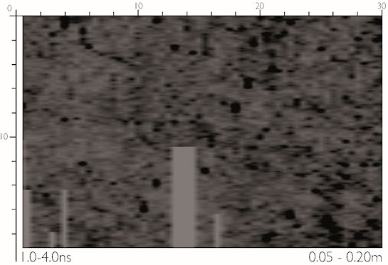
GPR Grid 3 was located in an area of the north-east quadrant of the fortress interior in which the magnetometer survey had not detected any conclusive archaeological anomalies, although the remains of buildings or roads could be expected from the reconstructed plan. The 1000MHz antenna was used to survey this grid and the time-slices (Figure 35) demonstrate the reduced depth penetration available with this frequency. A strong, anomalous response is noted around x=13-15/y=3.75 throughout the full depth of the data: the signal occurs only in a single line and is attributed to electromagnetic interference from an external source. Less than 0.25m below the surface, a group of irregular linear anomalies stand out. These are almost certainly mole burrows, as numerous mole-hills were observed in the surveyed area, with the GPR detecting the contrast of the voids. The time-slice showing 0.44–0.64m depth provides possible hints of archaeological features in the form of circular areas of slightly lower response approximately 4m in diameter, defined by a faint stronger response (e.g. at x=10, y=3 and x=19, y=9). However, these are extremely indistinct and no coherent features can be identified. The time-slice below this (0.64-0.83m) shows geological trends. As with Grid 2, this dataset is in agreement with the results from the gradiometer survey and the reconstructed fortress plan, which suggest sparser archaeological features in this area.
GPR was also used to survey an area of the garden of the existing manor house, Aggersborggård, on the southern side of the fortress (GPR Grid 6). This land had not been accessible for excavations during previous campaigns, but symmetry of the fortress design calls for a fourth gate in this area, the south gate (Figure 36). The survey was complicated by uneven terrain and by the presence of trees and shrubs, which had to be by-passed, causing blank areas in the surveyed grids. As the gradiometer survey shows, part of the garden area was also characterised by strong magnetic disturbances, the majority of which could be related visibly to modern disturbances or soil-improving materials. GPR profiles were thus collected at 0.5m separation in this grid, in order to provide an efficient means of evaluating the technique's effectiveness in detecting larger architectural features. The survey profiles (Figure 37) show considerably more point reflectors than other areas, as could be expected given the increased disruption. For practical reasons, it was not possible to correct for the changing gradient in this grid and some consequent artefacts are present in the processed data; the reduced spatial accuracy of interpretation because of this was a further reason why this survey grid was intended to give a broad-brush indication of the survival of large features in this area.
The time-slices (Figure 38) show that below c. 0.64m depth a shallow arc of disruption runs approx. east–west across the centre and southern half of the grid (x=0, y=14 to x=30, y=14, and parallel to this). To some extent this equates with the effect of the change of slope, but it also matches the curve and position of the extrapolated line of the inner face of the rampart (cf. Figure 22). Within this band – i.e. coinciding with the supposed position of the plank-covered street following the inner face of the rampart – it is possible to note, particularly in the time-slices for 0.93–1.23m depth, a number of weak radial trends aligned with the centre of the fortress. While these are too indefinite to represent evidence of specific structure in the rampart, their presence supports the conclusion that this area would be of interest to future investigations. At the same depths, a small area of increased response is located at x=12, y=3, which coincides with the predicted location of the axial road and may be worth further investigation. Throughout the time-slices, a strong linear response is visible, running slightly west of north from the south-eastern corner; the origin of this is unknown, although it coincides with a similar directional trend in the gradiometer data. This feature coincides with the supposed position of the east wing of the outwork projecting from the gateway area, as compared with the western gateway in particular. The deepest time-slices appear to indicate several coherent features, which may be anthropogenic or natural in origin: these include a possible right-angle response (x=18, y=5), several strong reflectors in the north-eastern corner and possible diagonal linears, the shape and location of which may be compared with drains visible in the photograph of the excavated east gate (Figure 5).