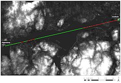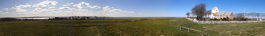
In addition to the geophysical surveys, a preliminary visibility analysis was carried out in order to illuminate the potential of the site as a central location. Aggersborg is located on the northern bank of the Aggersund strait, at one of the narrowest parts of the Limfjord, and is consequently an optimal place from which to control traffic through the fjord. This location leads into Livø Bredning, the area of water south-west of the fortress, where most of the Limfjord waterways convene. If, as discussed previously, the so-called Sløjen canal was open directly north into the Skagerrak, the potential of the site as a control point was even more pronounced. The fortress had an exceptional view over the fjord (Figure 39): one can easily see the islands Mors and Fur to the south, and in clear weather even Thy and Salling. To the east, the view is even more remarkable: from Aggersborg it is possible to see through a narrow corridor between Limfjord twists and turns, across open water deep into the eastern Limfjord. A comparable situation does not exist anywhere else in the area.
In order to investigate the visibility from the fortress further, data from the ASTER Global Digital Elevation Model (METI/NASA) was used to construct a number of different viewsheds from the location of the supposed watchtower in the centre of the Aggersborg fortress. The existence of this watchtower is not critical to the interpretation, as similar visibility could be achieved from the northern rampart, owing to the rising ground. These are only models of possible vistas, and should not be used without caution, but they do allow us to test ideas about visibility in this area. Different heights were modelled: 1.7m (an approximate height of a person not using a tower), and then metre increments from 3-6m to ascertain at which height a tower would be most effective. Results showed that, without a tower, only the immediate vicinity of the waterway would be visible but a modest tower (c. 4.5 metres plus viewer), allowing a view over the fortress buildings, would afford an excellent vantage point for much of the Limfjord.
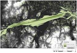
The model demonstrates that there is, at least in principle, a clear view of approximately 40km from Aggersborg to Aalborg (Figure 40). Here the line of sight will reach the steep hill of Voerbjerg at Lindholm, north of Aalborg. In addition to being the site of the well-known Viking-age settlement Lindholm Høje (Pedersen 1994), the place name Voerbjerg (derived from the word Warthe, 'mound or cairn by the look-out post') indicates that at one time this was part of an early communication system. At the top of the hill at Lindholm a house has been excavated that corresponds to the type found in the ring fortresses, and which must therefore be more or less contemporary with them. The location, which is quite unusual for a Viking-age house, may suggest that the hill was, at the time of the ring fortresses, a warning station.
 b)
b)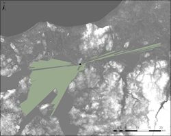 c)
c)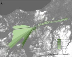
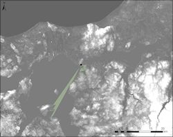
A basic line-of-sight map between the Aggersborg watchtower and the probable look-out post at Lindholm was constructed to test potential intervisibility (Figure 41). The fortress watchtower with viewer was assumed to have had a height of 6m; the viewer at Lindholm was assumed to be 1.7m in height, as no structure corresponding to the Aggersborg watchtower is attested here. The direct line of sight showed that, along this line, a large proportion of the Limfjord channel was likely to have been obscured from view, but that the prominent situation at Lindholm allowed any beacon to be viewed from Aggersborg under favourable circumstances.
A basic viewshed from both viewer points was also created to show the potential areas visible from both locations (Figure 42). The heights used were modest reconstructions, but even here it is demonstrated that the coverage of the Limfjord area is considerable. As the sites are more than likely intervisible, this adds credence to the assumption that they were sited to enable ease of control.
Although it is hardly possible to distinguish landmarks at a distance of 40km, it would almost certainly be possible to sight a bonfire. Ringtved has pointed out how Voerbjerg at Lindholm is within sight of another hill with a name derived from warthe, Storvorde, 10km east of Aalborg, from which in turn the Kattegat (the straits between Sweden and Denmark, south-east of the Skagerrak) is visible (Ringtved 1999). Aggersborg was thus a place that, in the event of conflict, offered a unique opportunity to send warning signals between the Kattegat and the central Limfjord in just two steps, and from which the signal might at once be passed on to large parts of the fjord country. From this perspective, the strategic position that Aggersborg occupied may well have contributed to the location of the fortress. This is emphasised when the comparatively poor view of the land compared to the waterways is taken into consideration.