Department of Archaeology, Durham University, South Road, Durham DH1 3LE, UK. Email:[email protected]
Cite this as: Nebbia, M. 2014 Review of Gabii Goes Digital [website], Internet Archaeology 36. https://doi.org/10.11141/ia.36.3
Gabii Goes Digital. Available: http://gabiiserver.adsroot.itcs.umich.edu/gabiigoesdigital/index.html
The Gabii Goes Digital website embodies the way archaeological projects may be standardised in terms of data recording and publication. It has been developed by a professional and multidisciplinary team in order to share and communicate the results of their research project using the most recent recording methods and techniques. It is an admirable example of the desire to exploit technological progress to service archaeological research.
As the team of developers from different universities in the United States and Italy (Rachel Opitz, Nicola Terrenato, Fred Limp, Elizabeth Robinson, Matt Naglak, Tyler Johnson, Jessica Nowlin, Emanuele Casagrande-Cicci) declares, the website is still a work in progress; it represents a pilot study for publishing archaeological data in the 21st century.
The Gabii Project is an international archaeological mission directed by Prof. Nicola Terrenato of the University of Michigan. Its aim is to study and excavate the ancient city of Gabii in the Lazio (Latium), a city-state, neighbour and rival to Rome in the first millennium BC. The adventure of Gabii Goes Digital started form the will of the team to communicate and share the project’s results in an innovative way, giving to the digital data the appropriate space in the publication process.
The project team is keen to make the publication of digital data and 3D models a peer-reviewed process, and their plan is to shape a community of peer reviewers who will develop dedicated skills enabling them to evaluate digital publications professionally through a series of conferences, webinars and meetings. This is the ideal path towards a standardisation of data publication where the necessity of quality controls is fundamental to making the process completely transparent and accessible to the scientific community. The message conveyed by Gabii Goes Digital is that in order to develop new ways of communicating scientific results, a proper evaluation of the process by which they are obtained is to be considered valuable compared with traditional publication procedures.
The website explains very clearly the entire workflow that the team pursued, showing full awareness and expertise of all the steps from data collection to publication. The decision to link best practice tutorials in the text, explaining data processing procedures adopted by the team, constitutes an added value and demonstrates a commitment to sharing and comparing the Gabii team's workflow and strategies with other researchers.
Gabii Goes Digital includes two samples of the digital documentation, the web-based database (a customized version of ARK, the Archaeological Recording Kit developed by L-P Archaeology) integrated with the 3D scene – which includes 3D (or rather 2.5D) models of a small part of Gabii's archaeological record – assembled using Unity3D (a software mainly used for games design).
The two digital products are meant to be linked together in a way that enables users to browse the scene – where a small number of stratigraphic units are displayed – and query single contexts through a digital context sheet in the database. The idea underlying the publication of 3D data in general is to represent the archaeological record as realistically as possible to allow users (be they scholars or non-specialists) to have a better idea of what the archaeological units/features looked like in situ.
The recording system using photogrammetry to produce 2.5D surfaces of the main archaeological features is quite widespread among archaeologists, but very few projects have started to develop the publication process to cope with this kind of data. Most of the projects which have adopted the practice of recording data in three dimensions still publish in conventional formats, due to the large amount of storage space needed and the relative novelty of the technology. Instead, the Gabii team brings the user/viewer onto the archaeological site in an innovative, semi-immersive way.
As the developers state, a compromise between speed and the level of detail had to be made: the higher the resolution, the slower the browsing within the 3D scene. This is the challenge that the Gabii team is tackling by publishing a sample of the data which allows the public to browse and explore the archaeological information in a relatively easy and light web-based 3D environment. The main problem with high resolution digital data is the large amount of memory needed to store the information. This makes the 3D Sandbox in the Gabii project website a heavy tool to use with a standard broadband connection.
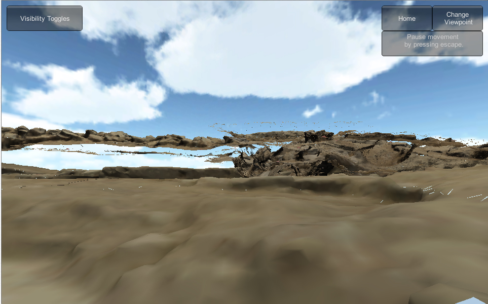
The model displayed in the sandbox is a fragment of the entire archaeological record; it comprises a selection of contexts where only the features which are important for the overall narrative are shown as textured meshes, with the "less important" layers represented by a simple polygon showing their extent. This wise choice makes the visualisation and browsing much faster than having the full high definition models or images for every context displayed.
The difficult task of displaying a 3D scene in a flowing way is, in this case, hampered by the huge size of the polygon representing the overlying stratigraphic unit, which prevents the user from easily navigating the textured models which have a much smaller extent. The meshes included in the sandbox are not real 3D models but rather 2.5D surfaces of the features recorded i.e. an overlapped surface showing the topographic expression of the feature itself. This can affect the intelligibility of specific stratigraphic sequences where different contexts seem to be floating and the meaning of the visual effect is not that clear (Figure 1).
Using photogrammetry to record archaeological features in the field can be very accurate and can give a sense of the morphology of a feature, but it is probably not the clearest way to represent the data in a publication. One possible solution would be to use a solid real 3D model based on voxels rather than pixels to provide a clearer representation of the third dimension. Without falling into the more extreme augmented reality, it is still worth further investigating the best approach to display the data in a simple way. In terms of the speed/detail ratio the challenge is to find the best compromise between the enormous volume of field data stored and the necessary amount of information needed to support the archaeological narrative of the site. Well aware of these problems, the team offers the expert user the opportunity to submit comments and suggestions for possible solutions.
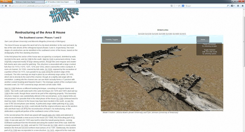
The second sample of digital documentation available on Gabii Goes Digital is the ARK Sandbox, a web-based database hosting the excavation documentation. The database includes a sample of the data collected on site, including digitally-reproduced context sheets comprising photographs and possible 3D models. The database is linked to the 3D Sandbox so that when a context is queried from the scene, the descriptive content of the database pops up providing the user with the information needed to understand the archaeological meaning of the textured scene. The point is to make the scene part of the narrative of the site and not just a nice object to play with. In this sense the Gabii team has taken a significant step towards a more fully integrated publication where the 3D-modelled archaeological features and the more traditional descriptive context sheets support the overall narrative of the site (Figure 2).
Data stored in the database are complete and exhaustive, although some of the attachments which are supposed to contain models of some of the stratigraphic units are empty. Again, the large amount of memory required prohibits the easy usage of these data by the user, affecting and slowing down the whole process.
The Gabii Goes Digital website includes a section where users can actively participate in the development of a community of peer reviewers through a number of webinars (web-based seminars), where scholars and researchers can exchange knowledge and promote best practices. A few extracts from the first webinar organised by the team are available on the website; fundamental topics regarding 3D modelling and user interface design have been discussed by a group of participants including members of the Gabii team itself and other scholars more or less involved in matters of digital recording and publication.
The establishment of this peer-reviewed framework for 3D data and generally greater use of digital data in archaeology is one of the principal achievements of the project. This is the way forward as more and more research projects are beginning to make use of digital recording systems and are producing massive amounts of data in their archives which need to be communicated and shared.
Although Gabii Goes Digital is a pilot study on publishing digital data, it indicates a standard procedure for every project producing this sort of information. The collaborative approach the project team have adopted should be applauded as sharing methods and approaches across the archaeological scientific community will result in a general raising of standards. The team’s main challenge is to reconcile the provision of full access to detailed data and their visualisation with the speed and size of electronic support required to make this information fully accessible to a wide community, which is after all the project’s underlying principle.
Overall Gabii Goes Digital is an extraordinary and stimulating adventure which will benefit from further inputs by different scholars, experts as well as the general public, in order to renew the communication of archaeological data in the already fully digital 21st century.
Internet Archaeology content is preserved for the long term with the Archaeology Data Service (ROR). Help sustain and support open access publication by donating to our Open Access Archaeology Fund.
Internet Archaeology is an open access journal based in the Department of Archaeology, University of York. Except where otherwise noted, content from this work may be used under the terms of the Creative Commons Attribution 3.0 (CC BY) Unported licence, which permits unrestricted use, distribution, and reproduction in any medium, provided that attribution to the author(s), the title of the work, the Internet Archaeology journal and the relevant URL/DOI are given.
Terms and Conditions | Legal Statements | Privacy Policy | Cookies Policy | Citing Internet Archaeology
Internet Archaeology content is preserved for the long term with the Archaeology Data Service (ROR). Help sustain and support open access publication by donating to our Open Access Archaeology Fund.