Cite this as: Macphail, R.I. 2015, Soil Microstratigraphy, in M. Atkinson and S.J. Preston Heybridge: A Late Iron Age and Roman Settlement, Excavations at Elms Farm 1993-5, Internet Archaeology 40. http://dx.doi.org/10.11141/ia.40.1.macphail
Thirteen thin-section and twenty-five bulk soil samples were analysed from Elms Farm. The main focus of attention was Period 2, the Late Pre-Roman Iron Age transition. Bulk samples from Periods 3-6 were also analysed. Soil micromorphology, supported by microprobe and FTIR analysis of one thin-section and chemical analyses were carried out. An integrated data/microfacies approach was undertaken in order to characterise the contexts under study.
The Period 2 settlement produced dark hollow-fill and pit fill deposits formed by the accumulation of a) charred dung-rich organic matter from likely in situ pounding of domestic animals, b) stabling waste from byres, c) domestic waste that derived from both the kitchen (food and cereal-processing debris) and the toilet (coprolites sensu stricto and night-soil), and d) scat remains of animals scavenging these deposits. Occupation spread across both areas of gravel and brickearth soils, where organic waste, probably derived largely from dung, fodder etc., was the dominant input into the soil. Such findings may imply the rural/market town character of Elms Farm. Findings from the less intensive study of later, Early Roman-Early Saxon soils, infer that the rural character of the settlement persisted.
Two phases of excavation were carried at Elms Farm, Heybridge, in 1993 and 1994/5 by Essex County Council as described in the Introduction. The site covers about 29 hectares in all. Of particular interest were Period 2 dark soil deposits, which occupied roadside depressions or extensive 'hollows' between Late Iron Age surfaces and Roman metalling. These deposits were variously interpreted as levelling dumps or flood deposits. In the post-medieval and modern period the site was known to have both a very high water table and to have suffered intermittent flooding. The correct interpretation of these dark soil deposits was an important archaeological aim in order to achieve a number of objectives related to the settlement (see below).
The aims and objectives (Atkinson and Preston 1998) of the associated soil studies were predominantly focused upon the characterisation of Pre-Roman Late Iron Age (Period 2) dark soil deposits in Area J, and sand and gravel soils in Areas E and I, and relate these to questions concerning,
The soil studies, as shown by the results from the 1996 soil assessment (Macphail, unpublished report to ECC), were also intended to contribute to the better understanding of the sites economy and relationship to the hinterland through the identification of evidence of animal husbandry.
Lastly, there was specific archaeological interest in the formation and origins of other deposits (see Samples below).
After an assessment of selected soil samples through chemical testing and soil micromorphology, seventeen extra bulk soil samples were received from Essex CC, and these were selected from contexts dating to Periods 1-6 and located in Areas G, H, I, J, K, M, P and R (Atkinson, pers. comm. 1999).
Thin-section and bulk samples are listed in Table 184 (.xlsx). Thin-section samples M1-M8 and their associated bulk samples were collected by Macphail. Thin-section samples M9-M13 (samples 1032, 1031, 1030, 1831 and 1830, respectively) were received from Essex CC (Peter Boyer, pers. comm. 1994). All these samples focused upon Period 2 contexts, the Late Pre-Roman Iron Age transition dating to the mid-1st century BC and mid-1st century AD (Ceramic Phases 10, 11-14). These provided samples for the detailed microstratigraphic analysis of the following contexts:
1. Surface deposits (M9-11)
1. Surface deposits (M12-13)
Bulk samples, for chemical signature analysis (Macphail et al. 2000), were selected from contexts dating to Periods 1-6 and located in Areas G, H, I, J, K, M, P and R (Atkinson, pers. comm. 1999).
A multi-analytical approach was adopted. These can be grouped conveniently as;
Undisturbed samples were air-dried, impregnated with a crystic resin mixture at the Institute of Archaeology, UCL, and manufactured into large (80x60mm) thin-sections at Stirling University (Guilloré 1985; Murphy 1986). Thin-sections (see Table 184) (.xlsx) were viewed at a number of magnifications from x1, up to x400 under the polarising microscope and employed plane polarised light (PPL), crossed polarised light (XPL), oblique incident light (OIL) and ultra violet light (UVL). The combined use of these different forms of illumination permit a large number of optical tests to be made, enabling more precise identifications of the materials under study (Bullock et al. 1985; Stoops 1996). For instance, if calcareous soil, mortar and ash-rich soil microfabrics were present at Elms Farm, these would have generally high interference colours under XPL. On the other hand, organic matter, phytoliths and calcium phosphate-cemented coprolites generally display no birefringence (zero interference colours). OIL is useful in identifying the iron mottled waterlogged (hydromorphic/gleyed) soils by their red and black colours. A number of soil inclusions were found to be autofluorescent under UVL, including bone, mineralised coprolites and some other anthropogenic features, which are discussed below.
Semi-quantitative data: In order to quantify variations in the microstratigraphy, semi-quantitative soil micromorphological data were gathered. This method, which has its basis in soil science, has been used on a number of occupation sequences since the early 1990s (e.g. Jongerius and Jager 1964; Simpson 1997; S. Carter 1998; Macphail 2000).
At Elms Farm, microfabric types, inclusions and pedofeatures (see Bullock et al. 1985), were counted semi-quantitatively, and this information was integrated with chemical signature analysis (see below) to identify microfacies types (Courty 2001).
After the soil microfabrics were defined according to their characteristics under PPL, XPL, OIL and UVL, structural features, inclusions and pedofeatures were counted, these include:
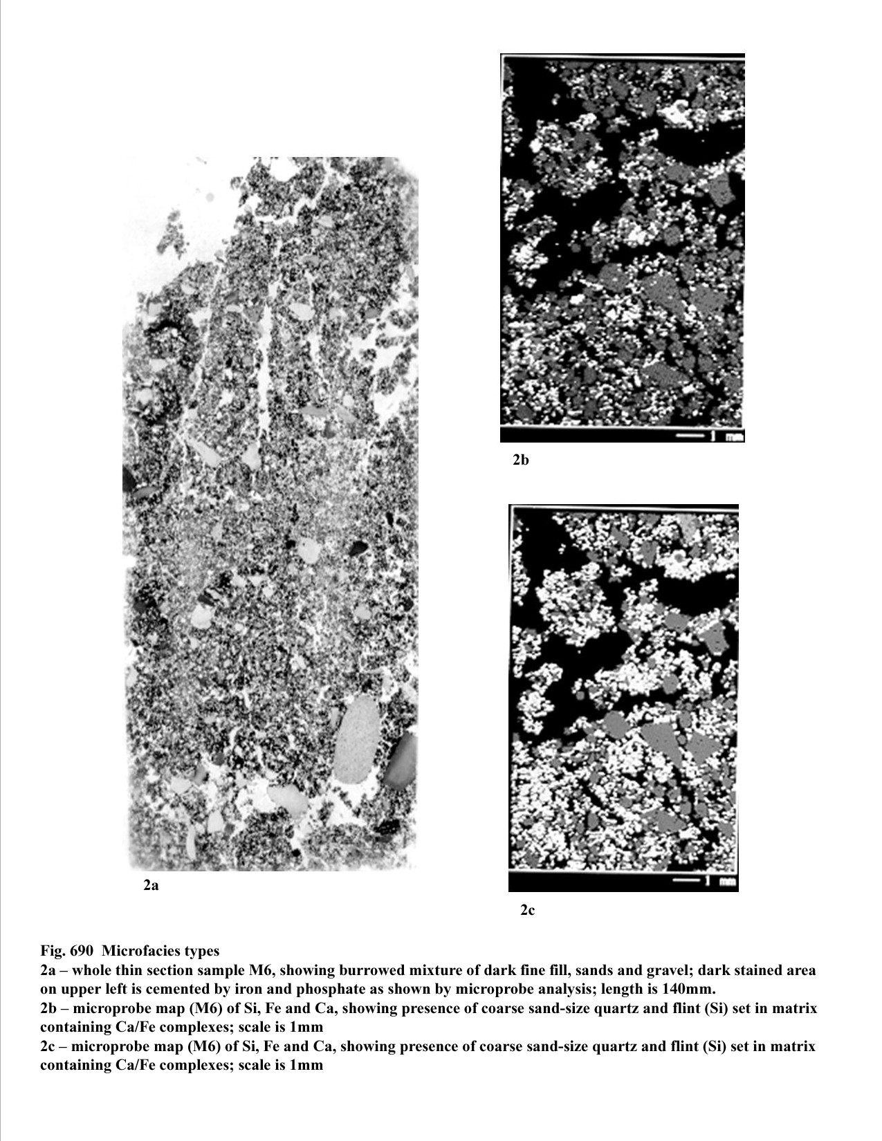
A Jeol JXA8600 EPMA was used at the Institute of Archaeology, UCL, to carry out microprobe analyses on orange-coloured cemented areas of soil in the uncovered thin-section sample M6. This area of interest was chosen for grid analysis, and elemental mapping. Amounts of Fe, Mg, Si, Al, P, Ca, S, Mn, K and Na were measured (reported as mean %). Elemental maps of Si, Fe, P and Ca were photographed from the VDU (see Figure 690). Attempts to analyse the mineralogy of this material were carried out at Boston University, employing a NEXUS 470 FTIR (Fourier Transform Infra Red) machine.
Bulk soil analyses were carried out at The Centre for Environmental Archaeology, Department of Archaeology, Umeå University, Sweden. A single, homogenised soil sample was used to measure LOI (Loss on ignition), low frequency magnetic susceptibility (MS) and 2% citric acid soluble phosphate (P2O5). Measurements were made of 2% citric acid soluble phosphate (expressed as ppm P2O5) and 2% citric acid-soluble phosphate after ignition at 550°C (expressed as ppm P2O5OI - on ignition). Inorganic P is usually determined by weak acid extraction (or by salt solutions). Citric acid extraction followed by molybdenum blue reagent, is a gentle and sufficiently selective method for extracting and quantifying inorganic-P (P2O5) (Arrhenius 1934; Arrhenius 1955). During this analysis, the first 2% citric acid extraction of P2O5 (ppm P2O5) measures inorganic phosphate. The following step of igniting the soil sample, converts organic phosphate into inorganic phosphate, and this, with the original amount of inorganic phosphate (already measured as ppm P2O5), is measured by the second 2% citric acid extraction of P2O5 (ppm P2O5OI). The ratio of P2O5OI/ P2O5 thus provides a P ratio of inorganic to organic phosphate, which can help differentiate soils enriched in manure and those containing high amounts of bone and mineralised coprolites (Engelmark and Linderholm 1996; Macphail et al. 2000). Data from P extracted by a HCl/Nitric acid method and 2% citric acid extraction of P2O5 have been compared at the sites of West Heslerton and Raunds, and show the same moderately high positive correlations; R2=0.7722 and R2= 0.7679, respectively. At Elms Farm, soils are generally acid (pH mean 5.4, min. 4.5, max. 6.8, n=17). pH (in water, H20) was carried out at the Institute of Archaeology, UCL. It should be remembered that ancient amounts of organic matter are likely to have been much higher than the relic amounts recorded now (as %LOI) because of oxidation, except when protected by cementation or when waterlogged.
Soil micromorphology, both description and the results of counting, are presented in Table 184 (.xlsx). Bulk sample analytical data and the results of microprobe analysis on sample M6, are also tabulated in Table 185 and Table 186 respectively (Figure 690, 2b and 2c).
| Na | Mg | Al | Si | P | S | K | Ca | Ti | Mn | Fe | |
|---|---|---|---|---|---|---|---|---|---|---|---|
| Mean | 0.04 | 0.113 | 1.28 | 12.308 | 0.223 | 0.025 | 0.327 | 0.683 | 0.053 | 0.053 | 0.568 |
| Standard Deviation | 0.035 | 0.098 | 1.043 | 8.969 | 0.242 | 0.013 | 0.25 | 0.607 | 0.057 | 0.057 | 0.489 |
| Range | 0.12 | 0.345 | 3.428 | 30.396 | 0.866 | 0.056 | 0.813 | 2.496 | 0.286 | 0.286 | 1.659 |
| Minimum | 0.000 | 0.000 | 0.002 | 0.11 | 0.000 | 0.000 | 0.002 | 0.043 | 0.000 | 0.000 | 0.0158 |
| Maximum | 0.12 | 0.345 | 3.43 | 30.506 | 0.866 | 0.056 | 0.815 | 2.539 | 0.286 | 0.286 | 1.674 |
Table 185 lists soils and their analytical data according to period. Soils are acid (pH, mean 5.4, min. 4.5, max. 6.8, std dev. 0.578, n=17). Amounts of relic organic matter are variable, but generally low to moderate (%LOI, mean 5.3%, min. 1.2%, max. 8.4%, std dev. 0.578, n=25). MS is also strongly variable across the site (MS x 10-8 SI Kg-1, mean 69, min. 8, max. 302, std dev. 69.880, n=25), while amounts of phosphate are generally moderately high (ppm P2O5OI, mean 2100, min. 550, max. 3480, std dev. 803.196, n=25). P ratios are mainly enhanced (P ratio, mean 1.8, min. 1.2, max. 3.4, std dev. 0.612, n=25). According to our present database, levels of phosphate are generally in the range of 'occupation' soils, with P ratios commonly indicative of inputs of organic phosphate, such as dung (Engelmark and Linderholm 1996; Macphail et al. 2000).
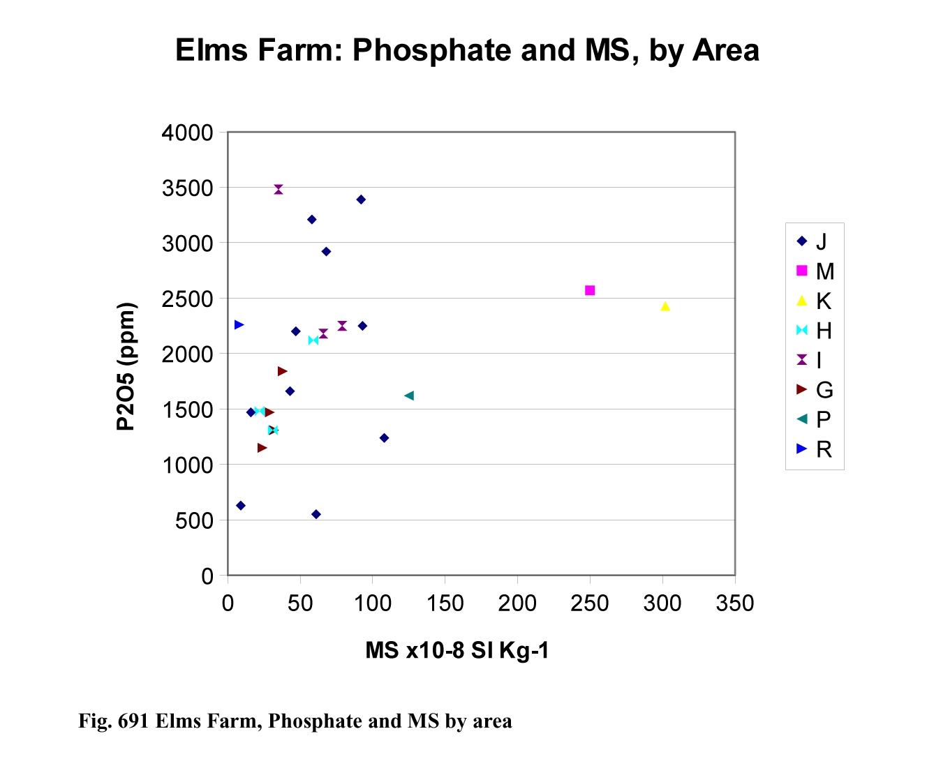

When %LOI, Phosphate and MS were plotted according to area or period, no particular patterns emerged (e.g. Figures 691 and 692), but the sample number is very small. Data more commonly reflects context and the microfacies groupings as identified below, because samples were selectively collected to aid the characterisation of specific contexts.
Soil micromorphology, magnetic susceptibility and chemical data are combined to identify microfacies at Elms Farm. In the case of sample M6, microprobe and FTIR studies also contribute. In the context of geoarchaeology, we can define facies, a term used in both natural history and geology, as the general aspect of an assembly of geoarchaeological data characteristic of a particular activity, context, locality and/or period (Courty 2001). At Elms Farm, field and laboratory data, along with archaeological context, permitted the identification of six main microfacies and their variants (microfacies types [MFT] 1a-1c, 2, 3, 4a-4c, 5 and 6).
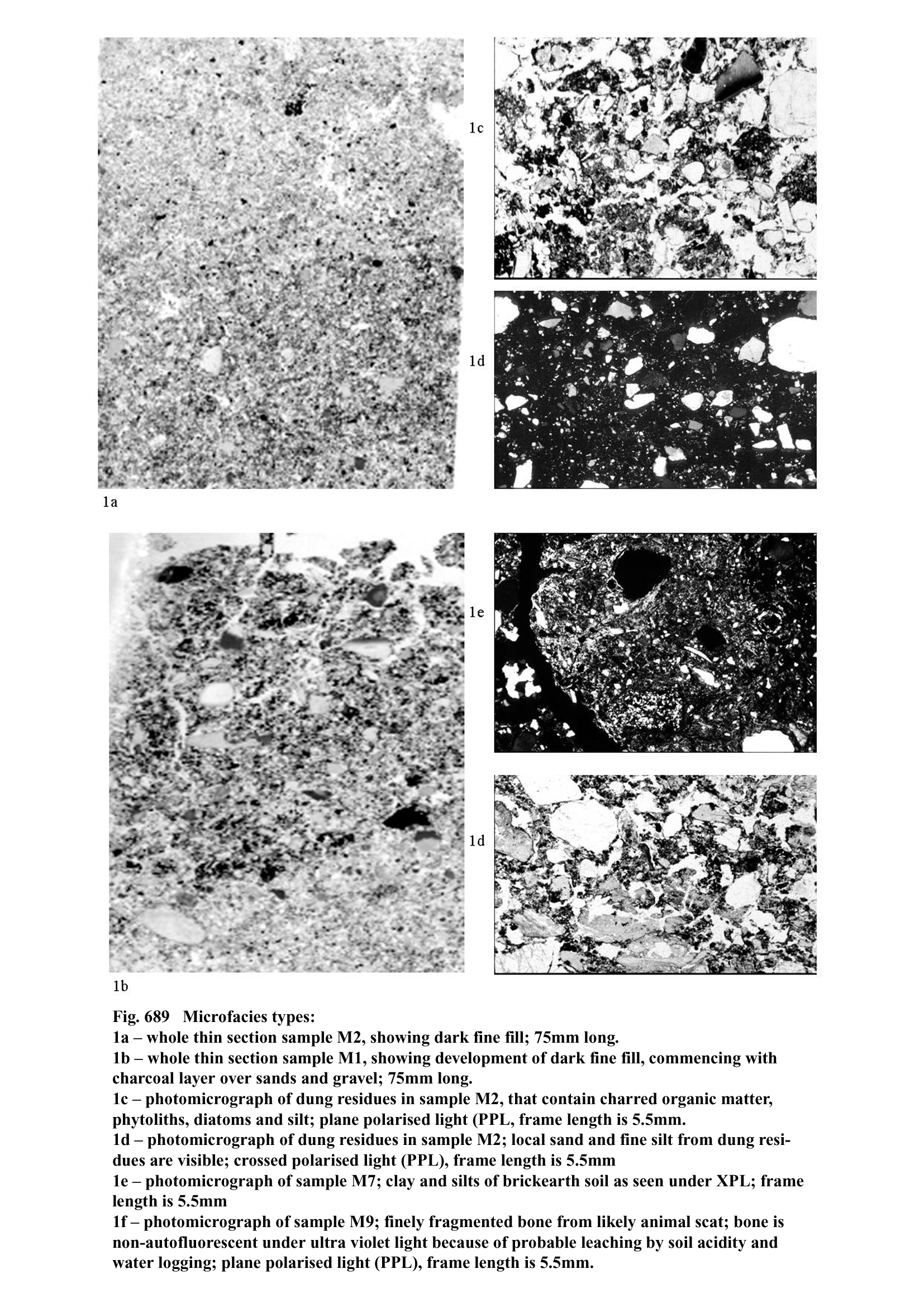
Microfacies types 1a-1c. These are the typical Period 2 brown (7.5YR5/4) sandy fills that occur in Area J. They are some 300mm thick deposits occurring under Roman gravel surfaces, and above Iron Age/natural sands and gravels (Table 184) (.xlsx). These 'dark fine' fills although dominated by sand-size quartz, also contain few stone-size flint (gravel). Also present are obvious wood charcoal and the remains of abundant fine organic matter, which is mixed with silt-size quartz, phytoliths and diatoms (Figure 689 1a, 1c and 1d). Fragments of animal scat and likely human coprolitic material that are autofluorescent under UVL, also occur throughout. Other small inclusions are >2mm long pieces of articulated phytoliths set in an amorphous yellowish cement. Amorphous yellowish-brown void infills and coatings are also present. MFT 1 is also characterised by rare to occasional dark-coloured dusty clay coatings.
In the samples analysed, microfacies 1b (M2) differs from MFT 1a, by containing more fragments of yellow cemented articulated phytoliths, and phytoliths and diatoms (including patches of abundant diatoms), while MFT 1a is more charcoal rich. MFT 1c (M6) is distinguished by containing many mm to cm size patches of yellow to dark brown-black amorphous organic matter with sheets of phytoliths and cellular material preserved - yellow amorphous matrix material staining into the surrounding fine fabric. Large areas (30mmx15 mm) of thin-section M6 are cemented by this amorphous yellow material.
All fills contain moderate to moderately high amounts of relic organic matter (3.8% to 5.7-6.0% LOI), and show either moderately high amounts of phosphate (2200 ppm P2O5) as in sample M2 (929), or high amounts of phosphate (sample M6: 2920-3210 ppm P2O5), some of the highest amounts of phosphate recorded at Elms Farm. These are equivalent to 960 ppm P and 1270-1400 ppm P, respectively (elemental P). The microprobe grid analysis (n=30) of the yellow amorphous cemented soil in sample M6 is therefore of interest. Here, a mean 0.22% P (or 2200 ppm P) (max. 0.87% P or 8700 ppm P; std dev. 0.242%) is recorded, along with, for example, a mean 0.57% Fe (max. 1.67%; std dev. 0.489%) (Table 186). Additionally present, as also recorded by microprobe mapping, are coarse flints (mean soil 12.31% Si; with individual clasts with 30.51% Si), and 'clay' (e.g., mean 1.28% Al). The matrix is made up of P/Ca (mean Ca 0.68%) and Fe/Ca material (Figure 690, 2b and 2c), that also includes 0.04% Na, 0.11% Mg, 0.02% S, 0.33% K and 0.57% Mn (mean values) as shown by elemental mapping. FTIR mineralogical analysis of the amorphous yellow cement produced a nearest fit of jarosite (KFe3(SO4)2 (OH)6. This may infer that the cement is an iron-rich breakdown product of ash containing Ca, K and S (Wattez and Courty 1987), the relatively large amounts of P present also inferring a possible 'night-soil' origin. This would be consistent with the presence of (phosphate) cemented inclusions of articulated sheets of phytoliths and cellular material, as found for example in cess pits, human coprolites and desiccated human intestinal remains (Goldberg and Macphail in prep.).
Analysis of bone, coprolitic material and these yellowish cements under ultra violet light, shows only some rare bone to be autofluorescent, indicating that strong leaching has occurred in these deposits, and that the cements are not forms of apatite, but more dominated by iron phosphates (Courty et al. 1989, 186-9). This is consistent with the acidic pHs (mean 5.4) on site and the common effect of high groundwater (Landuydt 1990).
Instances of 2mm long fragments of plant fragments and articulated phytoliths, with associated loose phytoliths and amorphous organic matter, that are cemented by amorphous yellow (likely phosphatic) material, can be identified as byre floor/stabling crust fragments (Macphail and Goldberg 1995; Macphail and Cruise 2001) (see discussion).
Microfacies type 2. This comprises the basal occupation deposits that underlie microfacies 1 at context 5211. They are similarly humic (3.7%), with the same MS (47 x 10-8 SI Kg-1), but have a lower phosphate content (1240 ppm P2O5OI). Thin section M1 shows how the deposit commences with a wood charcoal layer over the gravel-rich sands (Figure 689, 1b).
Microfacies type 3. This example of a brickearth clay floor (context 5506/5589) is both humic (8.4% LOI), with an enhanced P ratio (2.3), but relatively low phosphate content (550 ppm P2O5OI). It can be compared to the brickearth surface examined from context 6676 (microfacies 5).
Microfacies type 4a-4c. At context 5972 (microfacies 4a, sample M5), these represent sand and gravel dominated very poorly humic (1.2% LOI) and moderately poorly phosphate-rich (630 ppm P2O5) roadside or surface deposits. These show well-developed layering and leached microfabrics, the loss of iron being reflected by the very low MS (9 x 10⁻⁸ SI Kg-1) (Macphail et al. 2000). The deposits contain only rare instances of bone and a scatter of rare phytoliths, while likely amorphous iron-phosphate is rare compared to the abundant amounts of probably iron-dominated yellowish impregnations. Rare dusty clay coatings also occur.
Similar deposits occur at contexts 5883/5839/5935 (samples M9-M11, MFT 4b) sands and gravels are mixed with only very small amounts of anthropogenic inclusions, such as pottery, bone/scat (Figure 689, 1f) and hammerscale (Goldberg and Macphail in prep.) and charcoal, compared with MFT 1-2. On the other hand, much of the matrix material is composed of amorphous organic matter containing rare phytoliths, and this has been worked by acidophyle soil fauna that have produced very thin (<100 µm) organic excrements, such as produced by Enchytraeids (dominant below pH 4.8) and Collembola (dominant above pH 5.4). The leached and acid nature of the soil is further suggested by the bone in this soil being unusually non-autofluorescent under UVL (Courty, Goldberg et al. 1989).
In the case of MFT 4c (context 8067; samples M12 and M13), soils are similarly dominated by coarse material, although here a large proportion of this is composed of iron-stained brickearth material that has moderate interference colours and speckled, reticulate and grano-striate b-fabrics and void clay coatings (compare Figure 689, 1e). It also contains pale amorphous yellow void fills that because they are autofluorescent under UVL, can be considered phosphatic. The brickearth material can be identified as originating from a lower subsoil argillic B horizon (Avery 1990). Impregnative iron and manganese mottles are also more common, as well as iron depleted materials. The fine soil contains much amorphous organic matter and is frequently organised as burrow fills, and coarse (>500 µm) organo-mineral excrements are of likely earthworm origin. Both MFT 4b and 4c contain rare to occasional dusty clay coatings and amorphous likely Fe/Ca/P infills.
Microfacies type 5. This material is dominated by fine brickearth soil layers (context 6676: sample M7) that occur below some 270mm of Roman surfaces, and that merge into natural strong brown (7.5YR4/6-4/8) brickearth subsoil (see Discussion). The sampled, uppermost soil layers are far less porous (15-20% voids) compared with either the sands and gravels of MFT 4 (25-40% voids), or the dark fills of MFT 1 and 2 (20-35% voids). The soil was divided into three microfabrics (a-c), the most common being (b), a speckled grey clay-dominated fine soil that contains fine silt but very little sand (Figure 689, 1e). The material illustrated has low interference colours and can be identified as upper subsoil Eb horizon material (Bullock and Murphy 1979; Avery 1990). Little wood charcoal is present but large amounts of fine charred and amorphous organic matter occur as loose infills and burrow-fills (fine fabric c). These burrow fills also feature many to abundant multi-laminated thick (600 µm) dusty and impure clay coatings and intercalations. Iron staining and secondary yellow to brown amorphous iron and likely iron and phosphate impregnations are evident, and are reflected in the moderate levels of phosphate present (1470 ppm P2O5OI).
Microfacies type 6. Here context 13806 (sample M8) is an example of a pit fill in Area J. Again it is dominated by coarse sands and flint, but contains a wide variety of anthropogenic materials (Macphail 2000; Macphail and Cruise 2001). These include scarce wood charcoal - some as fragmenting 18mm diameter twig wood sections; rare instances of coarse (15mm) size bone, burned bone; occasional to many scat/nightsoil/human coprolitic bone and coprolites/night soil. Some of the last include bone and plant food residues (bran?). As in MFT 1, rare 1-2mm size patches of charred/humified plant lengths/byre fragments and amorphous organic matter, containing abundant phytoliths and rare diatoms, are also present. Fused cereal waste with very abundant phytoliths and vesicular silica fabric including melted flint, and vesicular sand rich nodules also occur rarely. These are calcium phosphate-rich, because similarly autofluorescent (UVL) fused cereal materials have recorded contents of 14.8% Ca and 6.8% P (Macphail 2000). Pedofeatures include amorphous yellow ferruginous impregnations and nodules, which are likely also to be phosphatic, given the associated presence of vivianite (e.g. Fe3[PO4]2 8 H2O) in these nodules. This pit fill is one of the most humic (8.1% LOI) and phosphate-rich (3390 ppm P2O5OI) deposits analysed at Elms Farm, and has an enhanced but not highly elevated MS (92 x 10-8 SI Kg-1)
The identification of unburned, but reworked brickearth (contexts 7430, 7431) in Area G is consistent with its chemistry (e.g., 1470-1840 ppm P2O5OI; 29-38 x 10-8 SI Kg-1) (Table 185).
Dark soil fills (MFT 1 and 2) Late Iron Age-Early Roman activity led to the infilling of 'hollows' with sand and gravel derived from the natural typical argillic gley soils (Hurst soil association) formed on river terrace gravel (Hodge et al. 1983). The junction between the gravel natural/gravelly Iron Age surface and overlying anthropogenic deposits is recorded in thin section M1 (Figure 689, 1b) and commenced with a charcoal-rich layer. Upwards the fill is still sandy, but generally finer (Figure 689, 1a). Small inclusions of bone, scat and coprolitic debris/night soil, are ubiquitous (see Figure 689, 1f), but other included anthropogenic material probably further increases the amount of phosphate upwards (from 550 ppm P2O5OI in sample M1 to 2200 ppm P2O5OI in sample M2). This included anthropogenic material is composed of amorphous and charred fine organic matter, rich in silt and phytoliths, and also includes diatoms (Figure 689, 1c and 1d). Moreover, fragments of yellow cemented plant and articulated phytoliths are likely relic of byre/stable floor deposits, or organic deposits that form at the base of dung heaps. Similar materials have been identified at Saxon West Heslerton and in experimental stable floor crusts at Butser Ancient Farm, and have been shown to be cemented by phosphate (Macphail and Goldberg 1995; Macphail et al. in prep.). The associated silt and diatoms is also typical of dung-rich debris and results from the ingestion of these during grazing and drinking by domestic animals, as argued at LBA/EIA Potterne (diatom analysis), LIA/RB Folly Lane (diatom analysis) and Roman rural Deansway, Worcester (Macphail 1994a; Macphail et al. 1998; Macphail 2000). The presence of dung residues can also be argued from the enhanced P ratios (1.2-1.3), despite a) the ubiquitous presence of mineralised phosphate in the form of bone/scat/coprolites, b) some charring of the dung and c) mineral phosphate formation in the byres and soil, because dung is rich in organic phosphate (Engelmark and Linderholm 1996). A similar P ratio was found in animal pound areas over pebbled surfaces at Deansway, Worcester, where bone and mineralised coprolites were also present (Dalwood 1992; Macphail et al. 2000). High water tables and soil acidity have also probably contributed to the weathering of any calcareous ash, and phosphate has been locally mobilised to form amorphous iron and phosphate-rich void infills and matrix cement. The last was analysed from thin-section M6, where on average 0.22% P and 0.57% Fe is present (max. 0.87% P, 1.67% Fe), although it was impossible to determine the exact mineralogy of the cement even using FTIR. At this specific location (context 5951/5987) animal dung waste was less important than phosphate cemented charcoal, sheets of phytoliths (bran?) and cellular organic matter - a complex nodular material that can be broadly described as 'night-soil'. Toilet waste was likely dumped into buckets that were then 'sweetened' with charcoal-rich ash. Similar materials, and their origins, have been discussed with Dave Sankey (MoLAS), and found for example as manuring inclusions at the non-calcareous environments of Roman/Saxon Oakley, Suffolk, and in reused wells/cess pits at Saxon Lake End Road West, Middlesex (Macphail et al. 2000; Macphail 2002; Goldberg and Macphail in prep.). In any case, a higher phosphate content was recorded here (2920-3210 P2O5OI) compared to context 5211 (2200 ppm P2O5OI) and may reflect a spatial difference, toilet waste dumping being more common here.
In these soil fills, the ubiquitous presence of excrements of soil fauna indicate the open nature of these sites. However, as they comprise the open areas associated with the temple complex (which was perhaps not formally bounded by fences in its earliest phase) the assumption must be that either animals were free to wander onto it or that the material in part derived from sheep awaiting sacrifice as they were led in to the sacred area. The overlying gravel surfaces constructed in the Roman period also contain evidence for the presence of livestock as identified at Deansway, Worcester, and some phosphate in the soil could possibly relate to this later activity. The use of the site by animals may also have been responsible for the formation of dark-coloured clay coatings, because these have been found to be rich in phosphate in soils that likely experienced animal concentrations (Courty et al. 1994; Macphail and Cruise 2001).
Roadside fills and gravel surfaces (MFT 4). The roadside fill at context 5972 (sample M5) seems to have developed through the dominant wash of sands and gravels from off the road (only 1.2% LOI). Very few anthropogenic inclusions occur in this layered deposit that involves a washed sand layer, although rare dusty clay and multi-laminated dusty clay void coatings and earlier-formed amorphous (possibly iron and phosphate) material commonly occurs as pans (630 ppm P2O5OI). This reflects the off-road washing of phosphate-bearing water, as also found in roadside contexts at Roman Scole, Norfolk and Deansway, Worcester (Macphail 1994a; Macphail et al. 2000). Later dusty clay coatings in the deposit testify to continuing wash from the road, consistent with the layered nature of the fill. Common periods of high water tables, consistent with the Soil Survey of England and Wales analysis of the area (i.e. gley soils), is probably responsible for leached and mottled deposits here, as also demonstrated by a MS of only 9 x 10⁻⁸ SI Kg-1 (Hodge et al. 1983; Bouma et al. 1990).
Gleying at contexts 5883/5935 and ?8067, produced similar mottling features in sand and gravel surfaces, that contained only few resistant anthropogenic materials, such as mineralised coprolite, pottery and hammerscale. At 8067 (e.g. M12) many subsoil Bt horizon brickearth fragments are also present, and it is plausible that these were reused from floors and other constructional usages, leading to the infilling of voids with secondary phosphate features and mottling stains. Similar features are recorded in brickearth floors from the Roman sites of Mount Roman Villa, Kent, the Courages Brewery sites, Southwark and Colchester House, City of London, (Macphail 1994a, unpublished reports MoLAS). Brickearth substrates are local to Elms Farm, Heybridge (see MFT 5) and have a mapped cover of typical argillic brown earth soils (Efford 2 soil association) (Hodge et al. 1983). These soils have a topsoil over a clay-depleted upper subsoil Eb horizon that is formed over a lower clay-enriched subsoil Bt horizon (Avery 1990). These clay-rich subsoils were commonly used for building purposes, as slabs for ground raising, floors and as wall slabs in 'clay and timber' buildings, in the Roman period.
It can be noted that at 5883/5935 and ?8067, the fine matrix is composed largely of organic matter that has been worked by soil fauna. The ultimate origin of this organic matter may be from dung and other organic waste being brought into the settlement. Why soils in context 5883/5935 should have such an acidophyle soil fauna compared to context ?8067 (earthworm-dominated), remains enigmatic.
Pit fill (MFT 6). The pit fill examined contains high amounts of organic matter and phosphate that seems to have both a domestic- and byre-waste origin. Night-soil and other coprolitic inputs are important, alongside fused cereal and burned mineral material. The presence of these burned inclusions helps account for the moderately enhanced MS (92 x 10-8 SI Kg-1) of this fill, but this MS is lower than some 'accumulations' recorded elsewhere on the site (Table 185: e.g., sample 728, MS 302 x 10-8 SI Kg-1; sample 513, MS 250 x 10-8 SI Kg-1). This is consistent with the absence of strongly rubified soil and strongly magnetic hammerscale in this pit, although hammerscale is present, for example in context 5883.
Clay floors and surfaces (MFT 3 and 5). In the shrine area a clay floor (MFT 3; context 5506/5589) is humic (8.4% LOI) but contains little phosphate (550 ppm P2O5OI) and has a low MS, indicating little mixing with night-soil/coprolitic waste, as found in the pit and hollow fills. This suggests that a 'clean' environment was maintained within the shrine. Although no thin-section has been undertaken, field analysis showed this floor to be manufactured from a likely subsoil Bt horizon brickearth deposit, as commonly found on Roman sites in the south of the UK (Macphail 1994b).
At context 6676, it can be suggested from stratigraphic analysis (MFT 5) that the likely natural/weakly reworked uppermost soil horizon (Eb upper subsoil horizon) has been affected by occupation. Local turf soil or its own topsoil has also been mixed into the uppermost levels of this argillic brown earth soil (Efford 2 soil association; (Hodge et al. 1983). The natural state of the soil is demonstrated by the very low MS (16 x 10-8 SI Kg-1). On the other hand, the soil has a relatively high phosphate content (1470 ppm P2O5OI), and this can be accounted by the inwash and downward mixing by earthworms of phosphate, now recorded as dark-coloured dusty clay infills and secondary amorphous (Fe/P) infills. This contamination probably derives from the use of the overlying Roman surfaces.
Area K. Here a burned (MS 302 x 10-8 SI Kg-1) and phosphate-rich (2430 ppm P2O5OI) accumulation was recorded (context 14067).
The overall character of the settlement, as based upon the soil data, can then be described as focused upon a rural/domestic economy, with Elms Farm possibly acting as a market centre for animal husbandry; an interpretation similar to that based upon soil analysis at Folly Lane, St Albans (Macphail et al. 1998).
The Early Roman pit fill (context 5637, e.g. MS 93 x 10-8 SI Kg-1; 2250 ppm P2O5OI) is chemically similar to that investigated from Period 2 (MFT 6), and may contain the same kind of domestic and non-iron working 'industrial' waste. A dark fill (context 6053, MS 31 x 10-8 SI Kg-1; 2210 ppm P2O5OI, P ratio 1.7) has a similar chemical signature to the dark fills described as MFT 1, and possibly has the same origin as a mixture of domestic- and animal-pounding waste (Table 185).
The chemical signature of examples from these mid- and Late Roman phases seem consistent with their archaeological description, and probably show a consistency of settlement occupation, as studied in detail from Period 2 (Table 185, Figure 691 and Figure 692).
The use of natural soil materials in floors in the latest Roman-Early Saxon period, is indicated by the very low MS values recorded (8-22 x 10-8 SI Kg-1), although, as in Period 2, these have been contaminated with phosphate (2260-2810 ppm P2O5OI).
Internet Archaeology is an open access journal based in the Department of Archaeology, University of York. Except where otherwise noted, content from this work may be used under the terms of the Creative Commons Attribution 3.0 (CC BY) Unported licence, which permits unrestricted use, distribution, and reproduction in any medium, provided that attribution to the author(s), the title of the work, the Internet Archaeology journal and the relevant URL/DOI are given.
Terms and Conditions | Legal Statements | Privacy Policy | Cookies Policy | Citing Internet Archaeology
Internet Archaeology content is preserved for the long term with the Archaeology Data Service (ROR). Help sustain and support open access publication by donating to our Open Access Archaeology Fund.