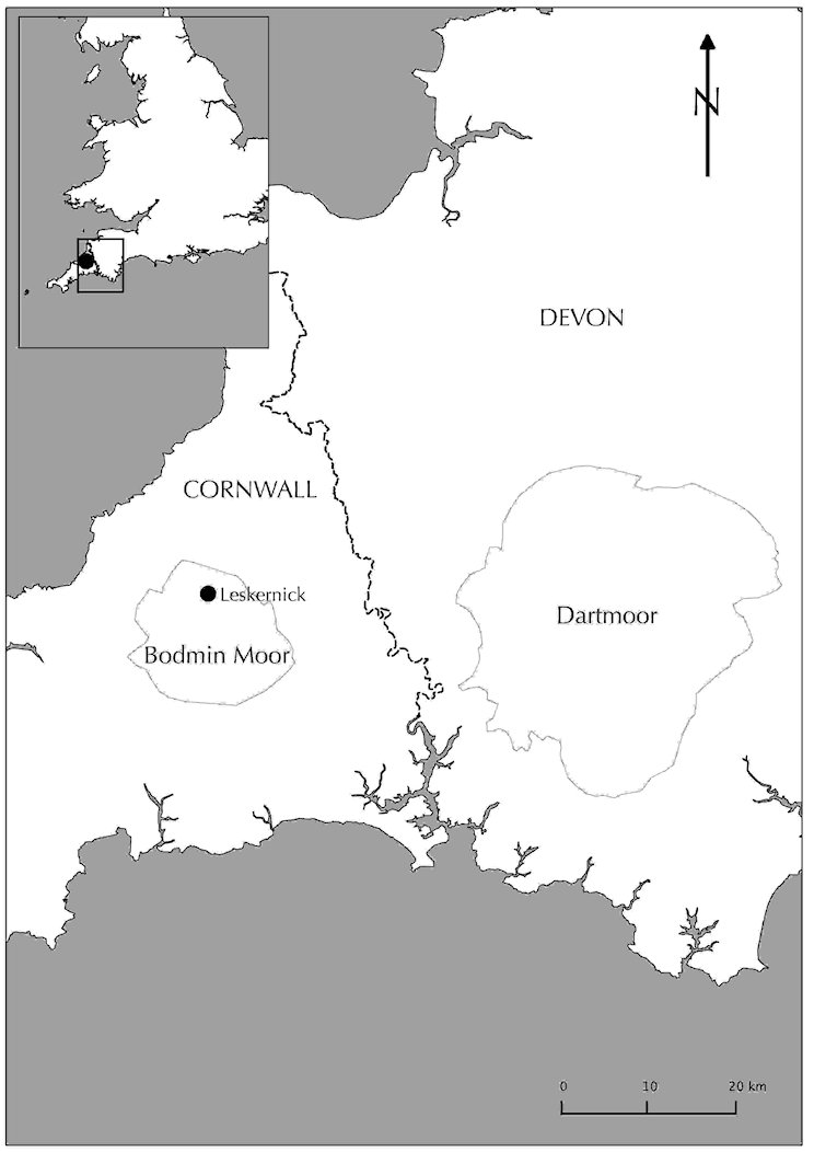
I first present an application of the embodied GIS undertaken within the Bronze Age landscape of Leskernick Hill, Bodmin Moor, Cornwall (Figure 4). Leskernick Hill nestles in the north-eastern part of Bodmin Moor in Cornwall. It is an unimposing hill, dwarfed, overlooked and virtually enclosed by a ring of surrounding hills. The advent of the Neolithic and Early Bronze Age in the UK brought the construction of various different types of ritual or ceremonial monuments, including long cairns, stone rows, stone circles and hill-top enclosures, many of which are found on Bodmin Moor and Leskernick Hill. As the late Neolithic transitions into the Bronze Age, we also begin to find widespread evidence of permanent and substantial domestic settlement areas, enclosures, fields and cultivation of the land (Tilley 1996, 167–68). This pattern continues through the Bronze Age, with approximately 50 round Bronze Age house circles in two distinct settlements on the hill by the Middle Bronze Age into the Late Bronze Age (1500-1000 BC). During the mid- to late 1990s, the domestic and ritual setting of the 50 roundhouses and structures of Leskernick Hill were subjected to an intensive archaeological and phenomenological investigation (Bender et al. 1997; 2007). A wealth of data were collected (including survey, phenomenological, and excavation records), making it an ideal candidate for testing the embodied GIS.
As part of previous research, I undertook a formal experiment to investigate the effectiveness of using visual augmentation in the embodied GIS to provide a feeling of presence in the landscape and to assess whether the embodied GIS helps in identifying the location, size and shape of the Bronze Age houses. The experiment is explored in full elsewhere (Eve 2014), and here I just present the results and a brief methodology.
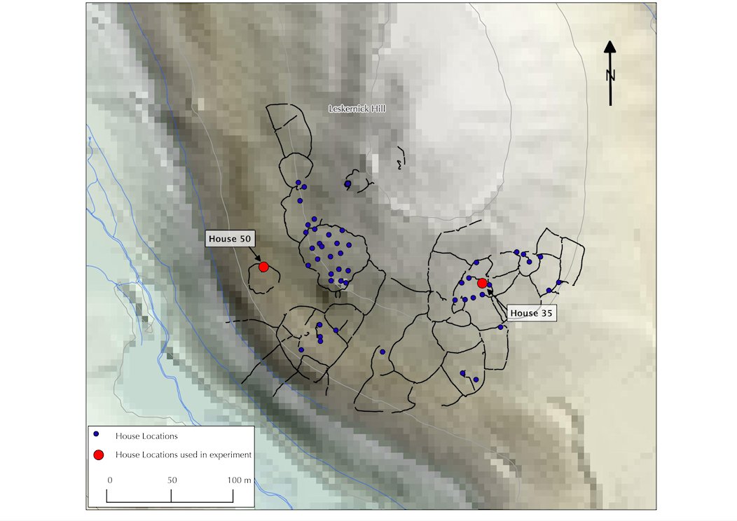
A 'traditional' GIS model of the hill was created, with two viewing areas specified (Figure 5). These locations were chosen as they have different perspectives on the rest of the settlement. House 50 stands slightly apart and has a view up a slope to the rest of the houses. House 35 is part of a cluster of houses, and was chosen to explore the feeling of being deep within the settlement. A series of tests were undertaken using different parameters from both viewing areas, where the participants were asked to count the number of houses they thought they could see without augmentation, with augmentation using small white spheres, and finally with fully rendered Bronze Age house reconstructions being augmented via the iPad screen, sized to fit the traces of the houses on the ground (Figure 6).
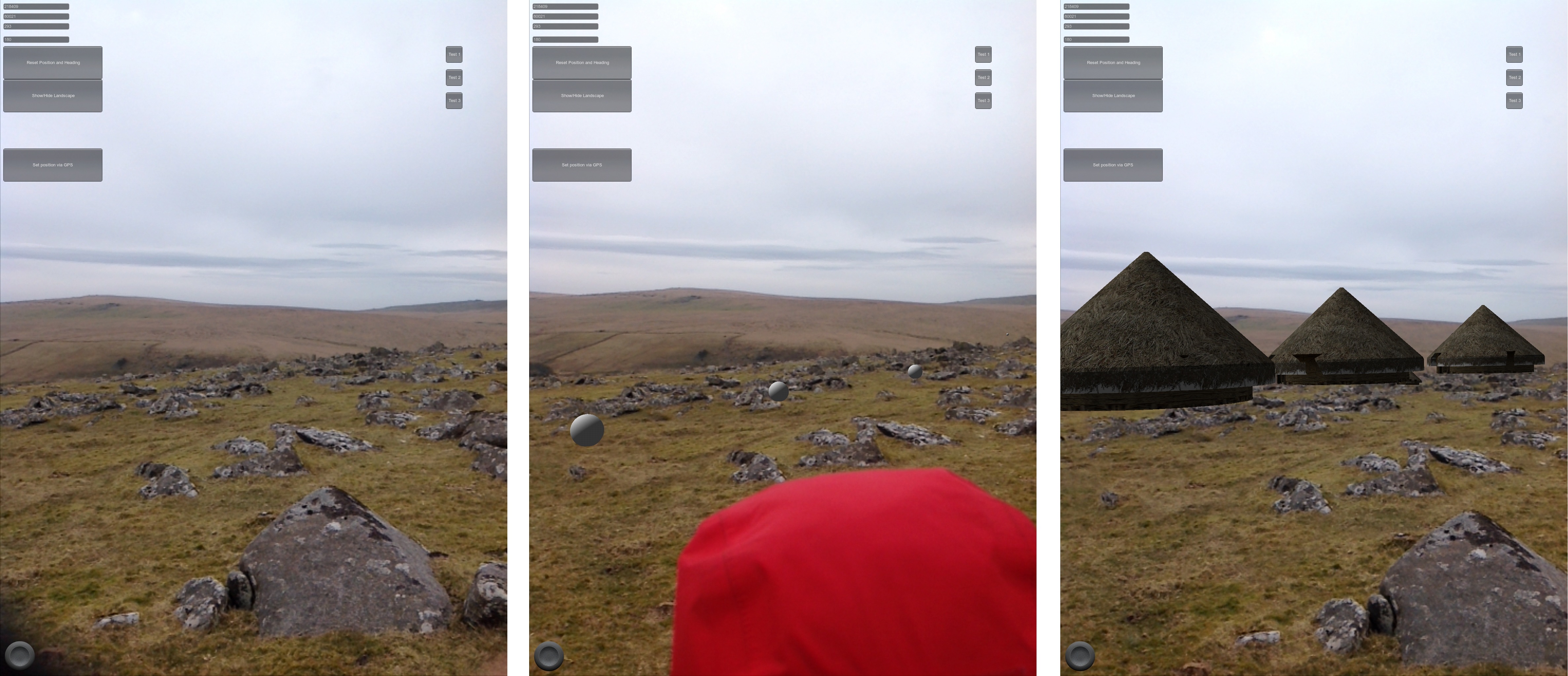
From both viewing areas, the number of houses seen when looking through the iPad (without any AR mediation) was less than the number of houses that can be seen without the iPad. The resolution of the iPad screen is clearly not as high as can be seen with the naked eye, flagging up the issue that any mediation through an electronic device will affect what can be perceived (Mann 1998); even though the Augmented Reality interface augments the view, it also diminishes some areas of perception because it is necessary to look through a screen. However (and perhaps unsurprisingly), when the fully rendered houses were shown the participants were able to identify many more houses (even those that were partly occluded behind others). The associated participant comments confirmed that the use of fully rendered house models added greatly to the feeling of a populated landscape and 'brought the landscape to life' (Eve 2014, 95–101).
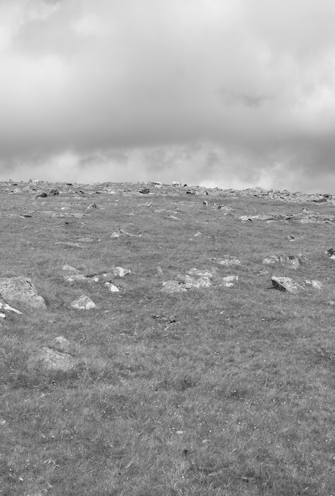
In this example, the embodied GIS provided a perspective on the settlement that would not have been possible to investigate using either traditional GIS or phenomenological techniques alone. The AR view that included the 3D models of the houses gave a very different impression of the number of houses that were being perceived, and as such gave the participants a perspective on the layout of the settlement impossible with the naked eye alone. The size and shape of the houses are of great importance, both for a feeling of presence but also for the actual overall understanding in terms of crowding and the feelings of enclosure. As an example, the viewing area towards House 50 looked up the hill toward the settlement. These house platforms are extremely hard to discern without augmentation owing to the jumbled nature of the archaeological remains on the skyline (Figure 7). When the white spheres were deployed at House 50, because of the small size of these a number were hidden behind the rise of the hill. However, when the house models were used the top of the roofs of a number of the houses could be seen, with the rest of the house being occluded by the real landscape or by other huts. Without the mediation of the AR device, the settlement on the skyline would simply not have been perceived.
The experiment as run did not engage with the palaeoenvironmental factors (i.e. vegetation cover, but see Ghadirian and Bishop 2008 for a modern example) or the issues of the contemporaneity of the houses. Future experiments could be run that build in these factors, and the power of using the GIS model as the background to the AR application would mean these parameters could be easily varied depending on the underlying archaeological evidence.
In addition, this experiment only investigated the use of the device at two locations (houses 35 and 50); however, the ability to move around the site and view it from any angle or location dynamically means that it is possible to use the AR application when undertaking any type of fieldwork on the hill or even beyond. For example, by using the application to view Leskernick Hill from the top of a nearby peak (Brown Willy) (Figure 8), the addition of the virtual houses immediately brings the settlement into focus and even though the forms of the houses themselves cannot be discerned, their presence breaks up the picture, suddenly creating a feeling of an inhabited landscape, just as would have been the case during the Bronze Age. The ability to move around and through this inhabited landscape also challenges certain assumptions made about the views from each individual house. Rather than looking out of your doorway to the wonderful landscape of Bodmin Moor, or to the nearest burial mound (as is so often assumed in both standard phenomenological and standard GIS analyses, see Eve 2014, chapter 7) – many of the houses simply looked out at the back of other houses. The embodied GIS allows us to approach the 'real' view of the settlement from any location, rather than the reified view created within the binary GIS or the lofty phenomenological walk.

Internet Archaeology is an open access journal based in the Department of Archaeology, University of York. Except where otherwise noted, content from this work may be used under the terms of the Creative Commons Attribution 3.0 (CC BY) Unported licence, which permits unrestricted use, distribution, and reproduction in any medium, provided that attribution to the author(s), the title of the work, the Internet Archaeology journal and the relevant URL/DOI are given.
Terms and Conditions | Legal Statements | Privacy Policy | Cookies Policy | Citing Internet Archaeology
Internet Archaeology content is preserved for the long term with the Archaeology Data Service (ROR). Help sustain and support open access publication by donating to our Open Access Archaeology Fund.