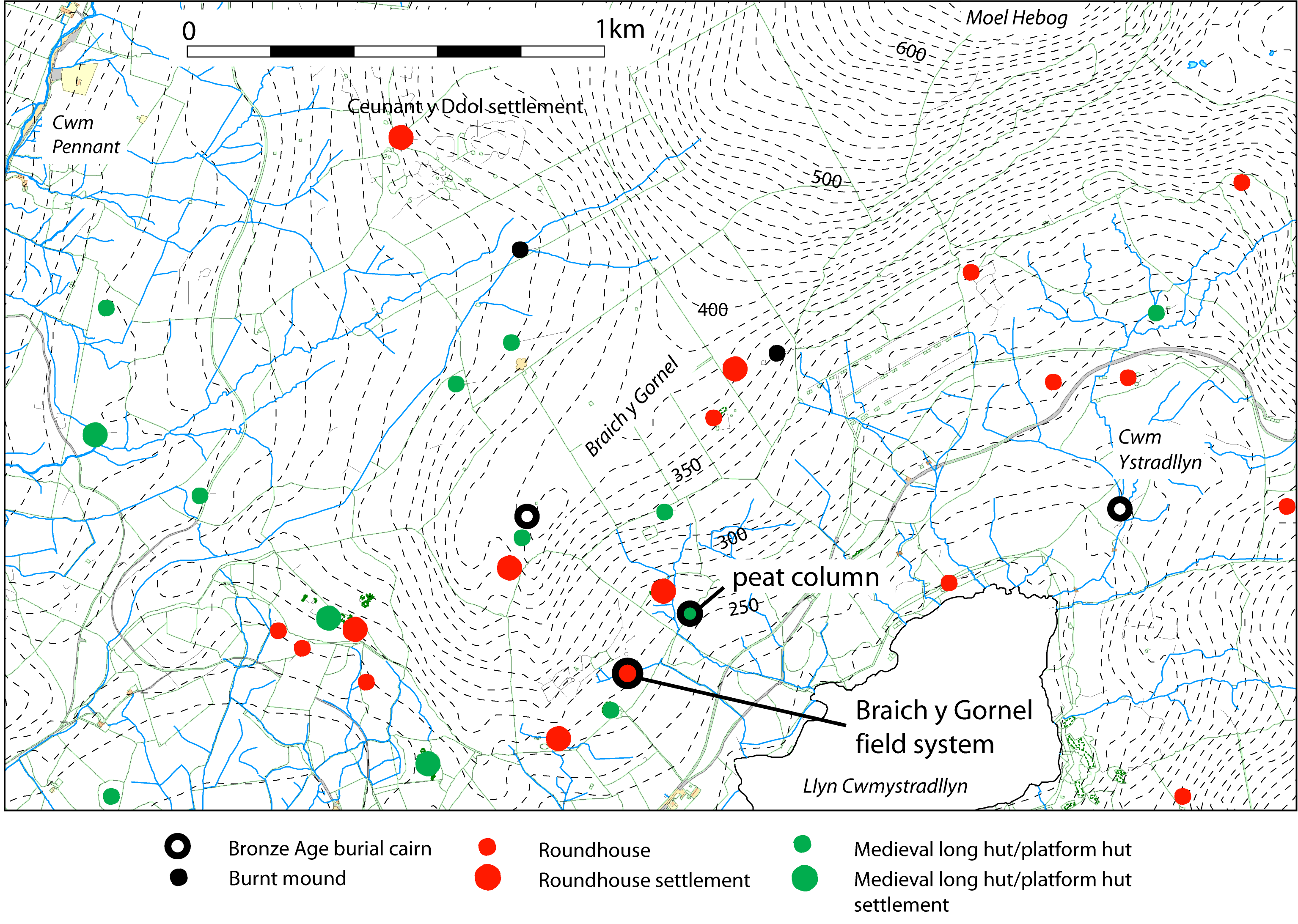
The second area of field system investigated is at SH 5525 4457 at a height of 270–290m OD on the south-east-facing hillside of the valley of Cwmystradllyn, north of Penmorfa, near Porthmadog (Figure 9). The name given to the site is taken from that of the ridge below which it lies. The lake within the valley below is now a reservoir and its water levels have been raised by damming. This discrete area of small, sub-rectangular embanked fields has survived so well because it lies on unimproved land that has been rough pasture since at least 1841 although lower down the slope are improved fields that were recorded as meadow and arable in the 1841 Tithe Apportionment (Llanfihangel-y-Pennant).
The fields are focused on a small, nucleated unenclosed settlement of two roundhouses conjoined with two small rectangular buildings. There is also one isolated outlying larger roundhouse (A), and within one of the fields is the platform of a small rectangular stone-built 'L-shaped' hut of probable medieval or post-medieval date (Figure 10). A survey of the field system was carried out in 1938 and some archaeological excavation of the nucleated settlement was undertaken by Gerhard Bersu in 1950 and 1954; a plan (on which Figure 10 is based) was published by the RCAHMW (1960) and the excavation results were written-up by Colin Gresham, who took part in the excavation (Gresham (1972). A geophysical survey of the field system, carried out as part of the present project, added some additional detail to the previous plan. The 1950 and 1954 excavations produced no datable finds and were carried out prior to the introduction of radiocarbon dating but by comparison with other excavated sites, such as those of Porth Dafarch, Anglesey (O'Neil 1940) and Cors-y-gedol, Meirionnydd (Griffiths 1958), the nucleated settlement is expected to be of Late Iron Age or Romano-British date.
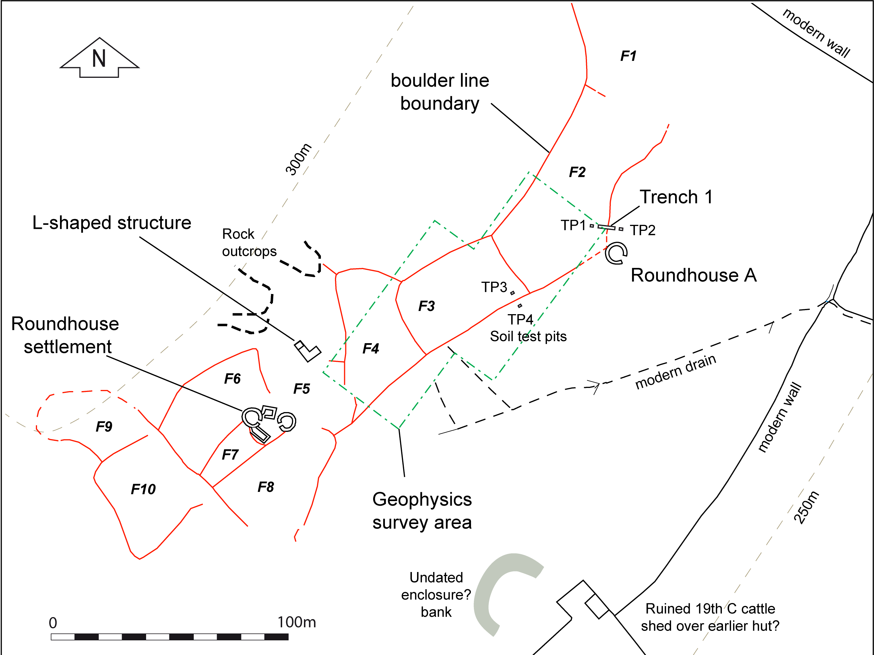
There are ten early fields here (Figure 10, F1–F10), at the margins of possible cultivation and just above the present limit of enclosed, improved pasture fields. The zone of marginal upland around the valleys of Cwm Ystradllyn to the south and Cwm Pennant to the north contains numerous recorded examples of settlement, both prehistoric and medieval in date as well as cairns and burnt mounds (Figure 9). The prehistoric settlement consists of both scattered huts and groups of huts, some associated with small enclosures, but none with terraced fields. A substantial area of early settlement also survives at Ceunant y Ddol on the ridge to the north, where scattered stone-built roundhouses lie within a series of curvilinear enclosures, unexcavated but just possibly of Bronze Age date (RCAHMW 1960, 937, fig. 73; 1964, xciv). On the hillside 1km to the north-east of the Braich y Gornel field system is a large burnt mound, and another just beyond the ridge to the north. On the ridge above the field system is a small cairn of presumed Bronze Age date, with another further to the east. The proximity of settlements to burnt mounds or to cairns seems significant.
The focus of Bersu's excavation was the unenclosed group of two roundhouses. However, a trial excavation was also carried out at the outlying roundhouse A, although this did not produce any dating or artefactual evidence (Gresham 1972). The field boundary close to roundhouse A was investigated as part of the present project. Bersu's work on house A was intended to provide background information to understand the soils of the area before tackling the more complex structures of the main settlement. The excavation showed that the house was large, with an internal diameter of 9m. It had a stone-faced earth wall and the floor was terraced into the hill-slope. The internal floor had a slab-covered drain but no post-holes or other internal features were identified. Bersu also opened a trench to the north-east of the house; this showed that the adjacent early field boundary did not join to the house wall so no stratigraphic relation could be ascertained between the two features.
Bersu's excavation of the nucleated settlement revealed two well-preserved small, stone-walled roundhouses, each about 5m internal diameter, and between them a small rectangular structure with a very narrow entrance, interpreted as a store-house. The entrances of the roundhouses faced onto a small 'courtyard' on a terrace, on which were traces of another rectangular structure. The houses were built into the steep hillside and the walls survived to over 1m in height, probably close to their original height.
Internet Archaeology is an open access journal based in the Department of Archaeology, University of York. Except where otherwise noted, content from this work may be used under the terms of the Creative Commons Attribution 3.0 (CC BY) Unported licence, which permits unrestricted use, distribution, and reproduction in any medium, provided that attribution to the author(s), the title of the work, the Internet Archaeology journal and the relevant URL/DOI are given.
Terms and Conditions | Legal Statements | Privacy Policy | Cookies Policy | Citing Internet Archaeology
Internet Archaeology content is preserved for the long term with the Archaeology Data Service (ROR). Help sustain and support open access publication by donating to our Open Access Archaeology Fund.