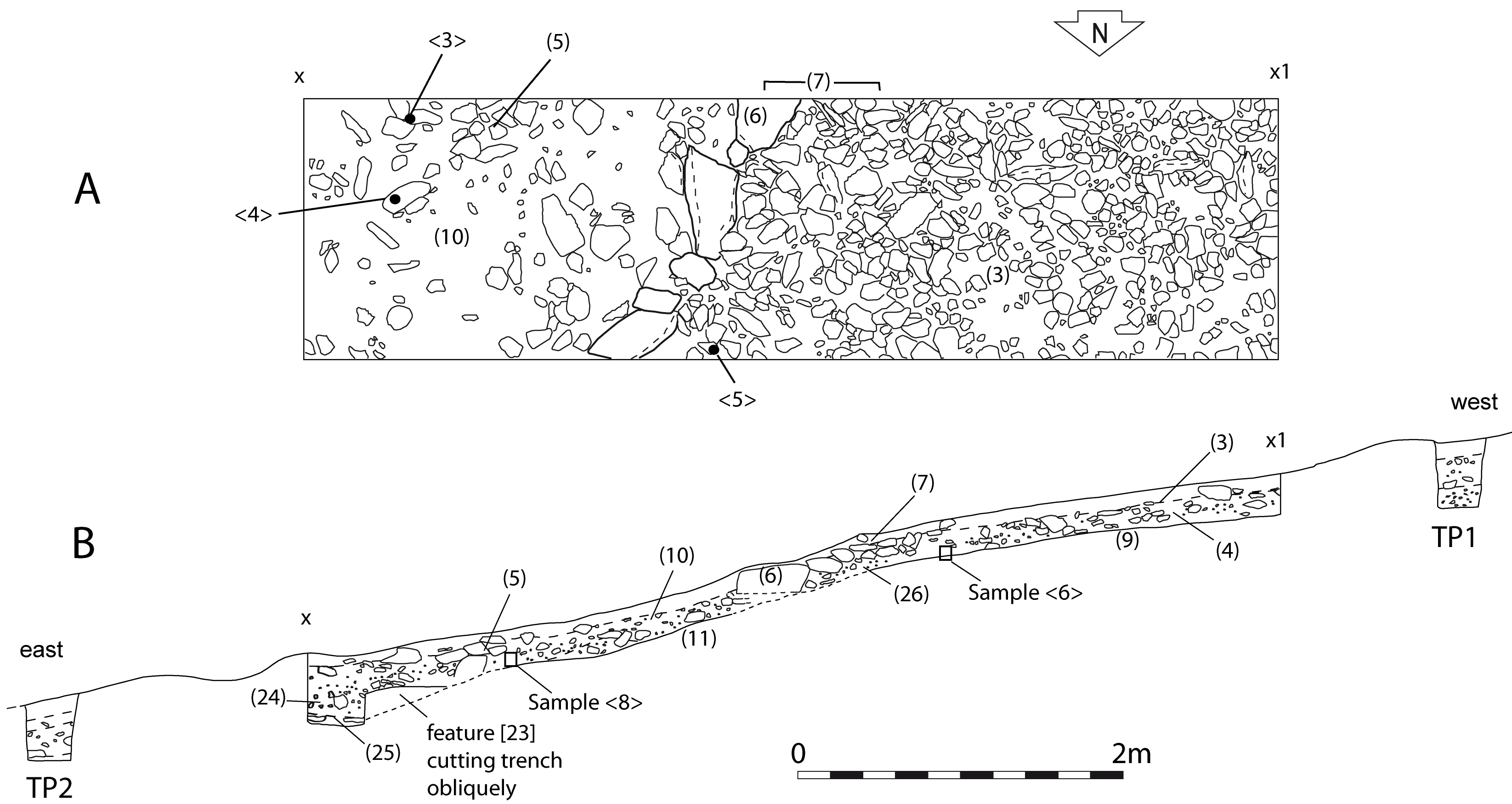
The excavation of Trench 1 showed that the very slight terracing visible behind the boundary was a result of a build-up of stony material, perhaps of clearance stones rather than of an accumulation of soil from cultivation. The soil within the field, upslope from the boundary, was shallow and not obviously suitable for cultivation and no plough or spade marks were identified.
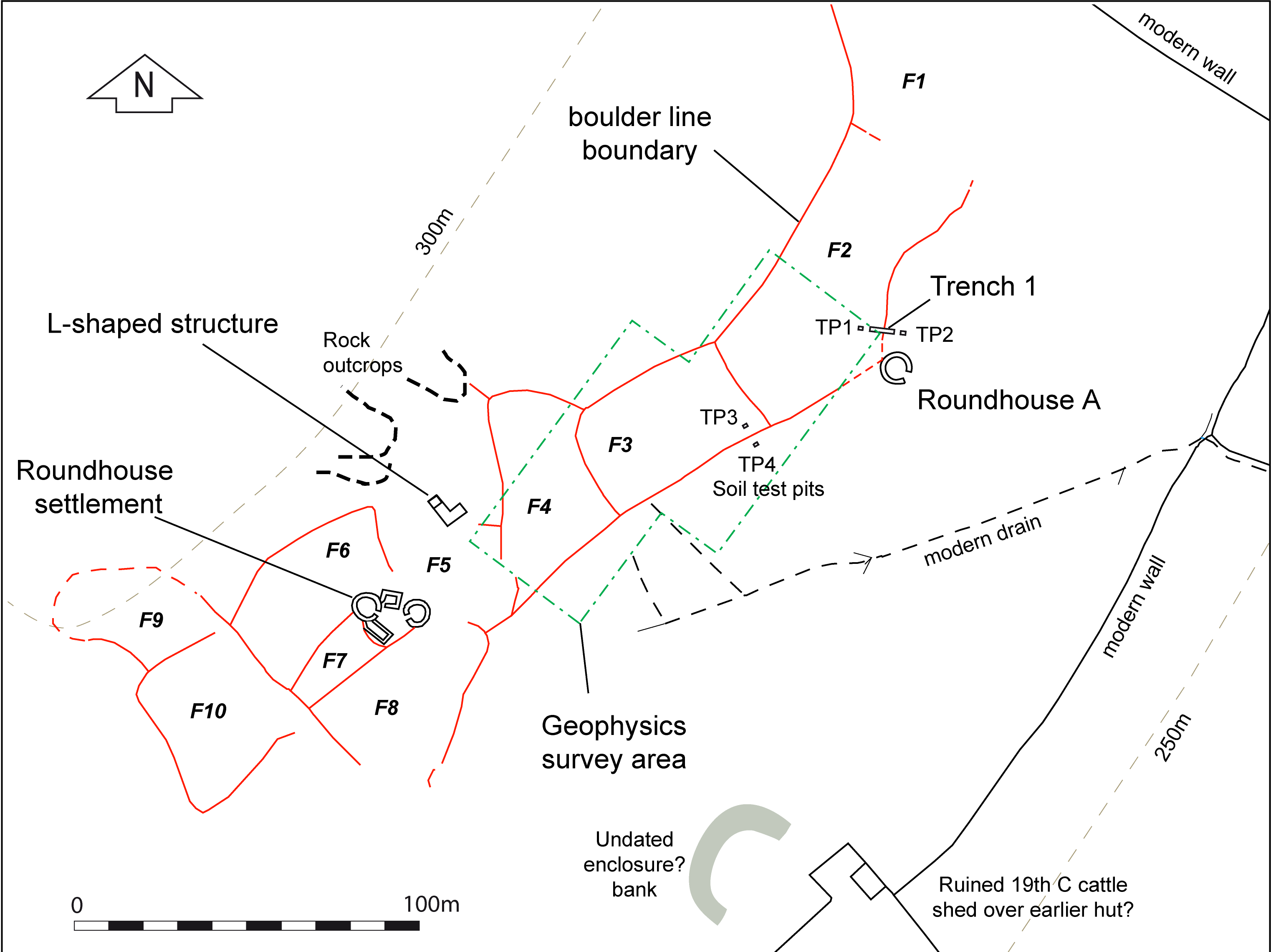
The main soil layer (10), downslope from the boundary, was quite different to that above, being more varied and somewhat compact, suggesting some difference in land use in each area. This could be the result of trampling associated with occupation of the nearby roundhouse A. However, the soil micromorphology showed no evidence of such activity but did suggest that there had been some build-up of soil from an erosion phase further upslope, before the field boundary was created. The AMS date of 2970±30 BP (SUERC-33059), 1310–1050 cal BC at 95% probability from oak charcoal from layer (10) could be residual from an earlier clearance phase, but it is also possible that it derives from occupation of the nearby roundhouse. This was much larger than the houses of the nucleated settlement and likely to belong with a different phase of settlement. The pattern of the fields does suggest that there was a group of fields, F1–F3, associated with roundhouse A, which expanded with the addition of field F4. These eventually merged with a group of fields F6–F8 that developed around the nucleated settlement and which expanded with the addition of fields F9 and F10 (Figure 10).
The geophysical survey did suggest that there might have been a phase of cultivation within the fields, shown by faint linear anomalies, possibly plough furrows, parallel to the contours in field F3. However, the soil upslope from the field boundary, within the field, did not produce any direct micromorphological evidence of cultivation but it did show that the soil was different from the typical podzolic soils of this area. The analysis suggested that it was acidifying, showing that the hillside may once have been more suitable for cultivation than is evident today.
It must be kept in mind that the soil evidence from this one place may not be representative of soils in other parts of the field system, particularly those closer to the nucleated roundhouse settlement and it would be desirable to carry out a more extensive soil sampling programme. However, there had clearly been settlement here, perhaps in more than one phase, and overall the evidence suggests that there had been some cultivation, perhaps of limited duration. The wider archaeological picture shows that the nearby upland was well-settled in the prehistoric period, with a probable main dependence on pasture and stock raising as was also probably the case at the Braich y Gornel settlement. The settlement and cultivation seems to have continued into the Romano-British period before a long period of abandonment, followed by evidence of sheep pasture in the historic period. The micromorphological evidence suggests that this took place more than 900 years before present, a period of land use that might be associated with the small L-shaped building in field F5.
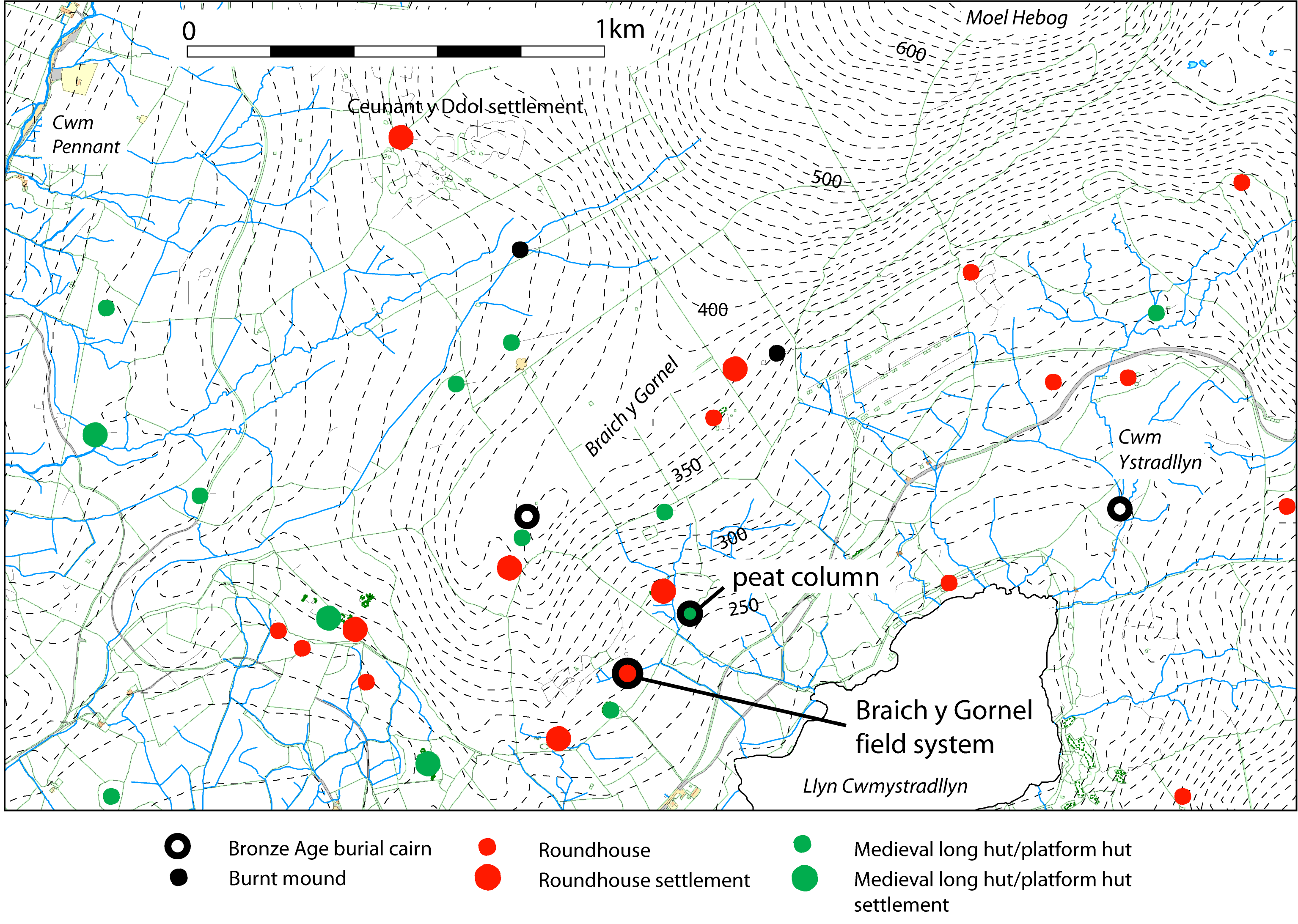
A peat column was taken for pollen analysis 200m to the north-east of the field system (see Figure 9) to provide understanding of the wider landscape and this identified a probable early phase of clearance as well as evidence of cereal cultivation in the Late Iron Age or Romano-British period (see below).
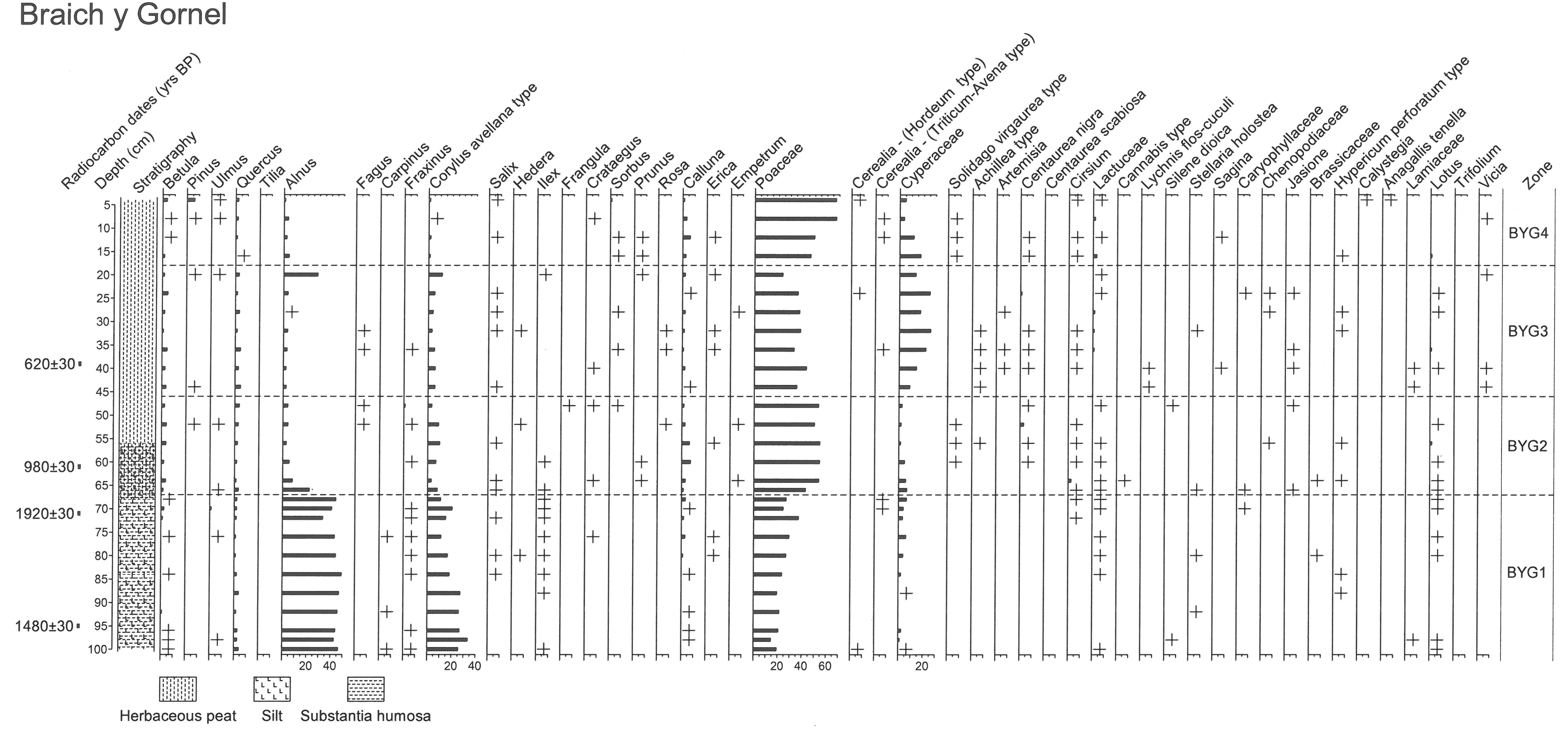
The pollen evidence (Figure 13a, Figure 13b; Table 12) from the basal peaty silts suggests alder and hazel dominated the local woodland, with only limited oak woodland during the first phase (zone BYG1) of the environmental record. Alder would have occupied the damper areas with hazel and oak on drier ground. An increasingly open environment is suggested by a decline in woodland taxa, initially hazel and then alder, though the range of arboreal species increases, including holly (Ilex) which is consistently represented. A brief recovery in alder and hazel woodland takes place shortly before the end of BYG1. Coincident with the beginning of the decline in hazel is an increase in microscopic charcoal concentrations which may indicate that fire was involved in the clearance of woodland. Along with grass pollen, other herbaceous taxa such as ribwort plantain, devil's-bit scabious, bird's-foot-trefoil (Lotus) and buttercup type suggest a predominantly pastoral landscape with livestock farming as the main land use. The occasional fungal spore indicative of dung provides additional support for this view. Towards the end of BYG1 a slight increase in heather may indicate increasing acidification of soils in the area. There is, however, some possible evidence for cereal cultivation. The occurrence of Hordeum-type cereal pollen at the beginning of the record could indicate cultivation of barley, or the presence of particular wild grasses, whereas the presence of Triticum-Avena cereal-type pollen at the end of BYG1 suggests the cultivation of wheat or oats and provides firm evidence for mixed farming in the area. The latter coincides with a further decline in hazel after the brief recovery in woodland. Microscopic charcoal values peak immediately before this and may reflect anthropogenic activity locally.
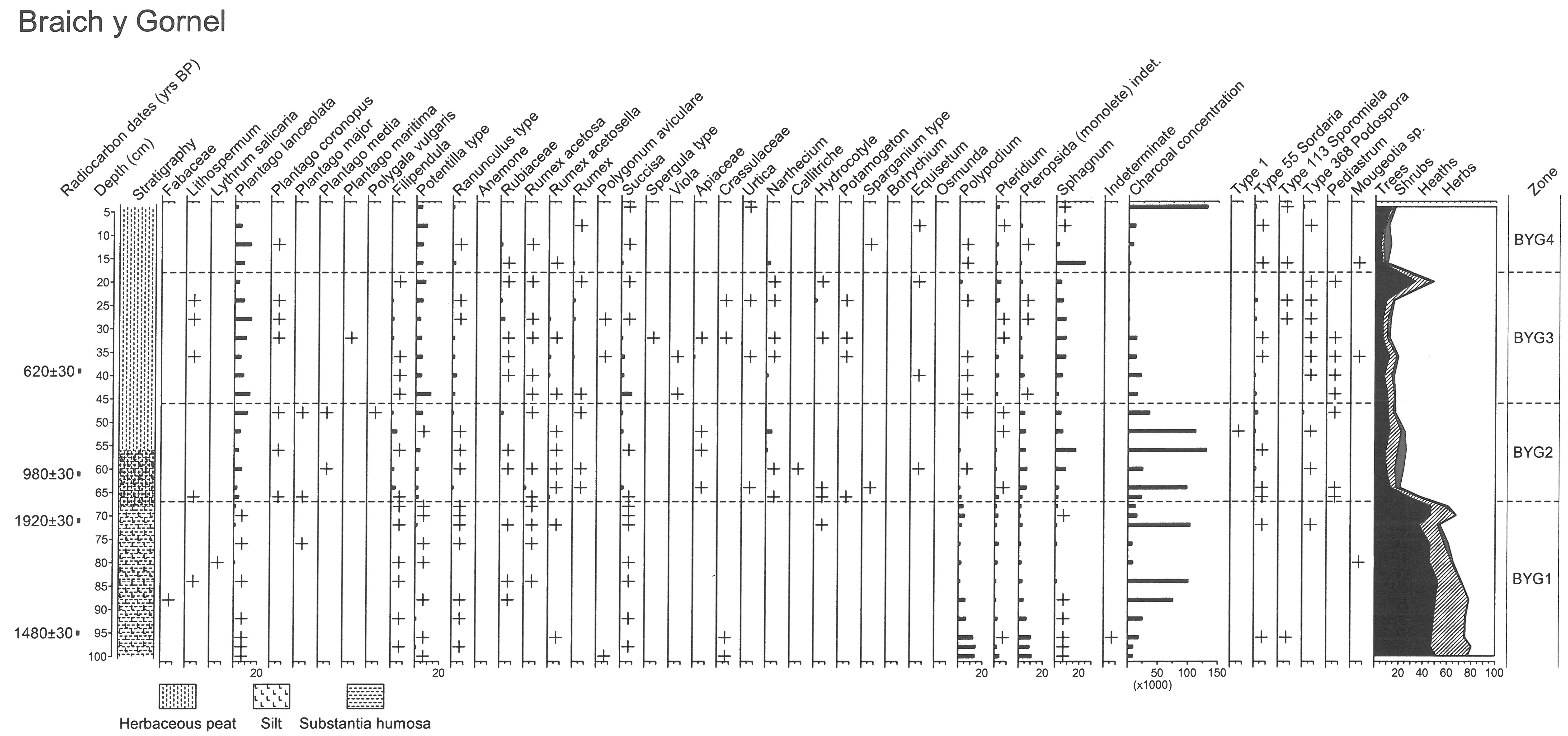
A radiocarbon date (Table 13) of cal AD 540–660 (Beta-312792: 1480±30) from near the beginning of BYG1 suggests the record commenced during the Roman period or Late Iron Age, but a Late Iron Age/Roman date of cal AD 20–130 (Beta-360402: 1920±30) from near the end of BYG1 suggests the record commenced earlier, perhaps during the earlier Iron Age or Later Bronze Age, or even earlier during the Bronze Age. If the latter date is accepted (see further discussion below) then the vegetation changes during BYG1, namely the decline in hazel and alder woodland and the increase in charcoal, may relate to activity associated with the roundhouses, either the single large, stone-built roundhouse to the east of the field system or the two small, stone-built roundhouses associated with the small sub-rectangular fields. Another possibility is that the field system is broadly contemporary with the vegetation changes at the end of BYG1, namely a decline in hazel woodland and appearance of wheat-oat cereal pollen just after the date of AD 20–130, suggesting activity in the Late Iron Age to Romano-British period. A peak in charcoal immediately before the date of AD 20–130 may also signify human activity in the area and overall the vegetation changes may reflect human activity in the area for much of the Iron Age. The slight expansion in alder and hazel woodland towards the end of BYG1 may indicate some attempt at woodland management, perhaps to provide fuel or building material.
A marked decline in alder and hazel woodland (BYG2) is accompanied by increased representation of grasses, together with herb taxa including ribwort plantain, tormentil type, common knapweed, thistle and goldenrod and a change to a herbaceous peat from a silty peat, the latter possibly reflecting a change in drainage conditions as a result of woodland removal. Although woodland was limited, a range of species is indicated in the area including birch, willow (Salix), blackthorn (Prunus), hawthorn (Crataegus) and rowan (Sorbus). The herb taxa suggest pastoral farming was the main land use and fungal spores indicative of dung provide further evidence for this. Heather also increases, perhaps indicating increasing acidification of soils in the area and the appearance of bog asphodel may again indicate acidic soils and local bog vegetation. Pennywort, pondweed (Potamogeton) and bur-reed (Sparganium type) suggest wetter pools on the mire surface, while other herb taxa such as meadowsweet and tormentil may also have been growing on the mire surface. Two peaks in microscopic charcoal concentrations suggest fire activity in the area and perhaps local burning. The first charcoal peak occurs shortly before cal AD AD1020–1050, cal AD 1080–1130 and cal AD 1130–1150 (Beta-312791), while the second peak occurs after this date. A slight recovery in hazel woodland occurs at the same time as the second peak in charcoal. Either peat accumulation was very slow during the earlier part of zone BYG2, as the date is a little too early, or there has been some disturbance to the record.
An open landscape continues to prevail throughout the period represented by BYG3, with an increase in sedges locally. A very brief expansion in alder and hazel occurs towards the end of the period. Grassland indicators, especially ribwort plantain and tormentil type, are more strongly represented and fungal spores indicative of dung are more frequent, attesting to livestock farming being the main land use. However, the occasional cereal-type pollen suggests cereal cultivation locally or in the wider area. Triticum-Avena-type pollen occurs shortly after a date AD1290–1400 (Beta-312791: 620±30 BP) while Hordeum-type occurs later. A decline in charcoal concentrations perhaps indicates a change in activity or occupation in the area, although grazing activity seems to have continued at a similar level. This possibly equates with a downturn in climate, commonly referred to as the 'Little Ice Age'. It is possible that any of this activity may be associated with the small rectangular stone-built hut of medieval or post-medieval date lying within one of the fields.
Finally, there is a renewed expansion in grassland communities during BYG4, possibly at the expense of sedges. Although pastoral farming is the main land use, the occurrence of cereal-type pollen may relate to more recent arable farming and an expansion as a result of economic pressures such as the Napoleonic wars. There is also some evidence for renewed afforestation involving pine, as well as evidence for local burning activity, perhaps associated with land management.
Internet Archaeology is an open access journal based in the Department of Archaeology, University of York. Except where otherwise noted, content from this work may be used under the terms of the Creative Commons Attribution 3.0 (CC BY) Unported licence, which permits unrestricted use, distribution, and reproduction in any medium, provided that attribution to the author(s), the title of the work, the Internet Archaeology journal and the relevant URL/DOI are given.
Terms and Conditions | Legal Statements | Privacy Policy | Cookies Policy | Citing Internet Archaeology
Internet Archaeology content is preserved for the long term with the Archaeology Data Service (ROR). Help sustain and support open access publication by donating to our Open Access Archaeology Fund.