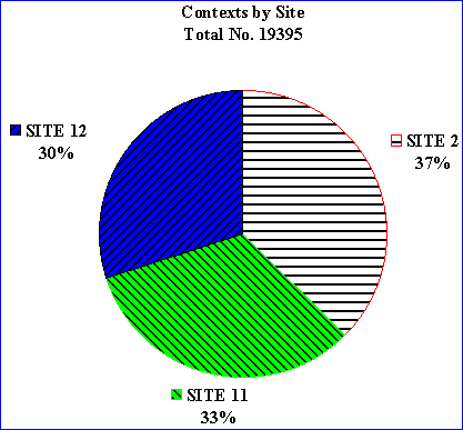
Fig. 3.2 Contexts by site
The excavation record includes nearly 19,500 context records, of which just under 9,500 are derived from over 4,200 post-holes, 135,000 objects and more than 600,000 animal bone fragments. It is significant that nearly a third of the data recovered derive from the excavation of Site 12 in 1995, where the stratigraphic component is much higher than in the two sites to the north. The record collectively represents about 7000 individual cut features and associated surfaces which can be grouped into a number of classes. These include structures, especially the Post-hole buildings and the Grubenhäuser, as well as ditches and gullies, pits and associated features, as well as surfaces which incorporate both the extensive midden deposits identified in areas 2CA, 2DA and 2DB in particular, buried soils and utilised surfaces such as a number of pebble spreads found in areas 11BA and 11AD and on Site 12.
Of the complete record, some 880 contexts comprise the cuts and fills of natural features such as solution holes, which were frequently almost indistinguishable from post-holes prior to excavation, and a further 500 were not classified in the field. As is generally the case on large rural sites with sandy soils, the resolution within the stratigraphy is poor with most features having few readily distinguishable fills. In the southern part of the site, however, a complete stratigraphic sequence survived. The methodologies employed have generated a record that is both uniform in quality and suitable for computerised analysis; the high degree of spatial precision in the record will be fundamental to the analysis of the data.
The West Heslerton archive is large, well-provenanced and well recorded; it offers immense analytical potential andn could be the cornerstone of a core data-set in a complete reappraisal of Early Anglo-Saxon settlement in England. The site is potentially singularly important for the examination of the transition from Roman to Saxon, although for this to take place further work would be required on the remaining unexcavated portion of the settlement.
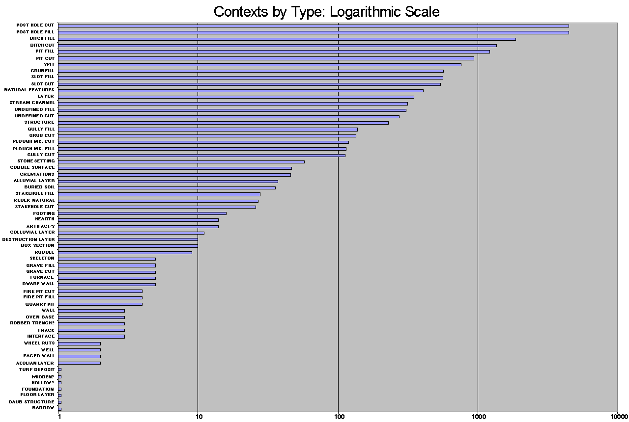
The context recording method is reflected in the chart of context types in which contexts were primarily identified as either cuts or fills, a distinction which determined the exact record structure for subsequent data entry. By far the most frequent context type was the post-hole which represents about a quarter of all recorded contexts, in excess of 4,200 post holes relating both to the rectangular post-hole buildings and the Grubenhäuser. The next most significant group are the Grubenhäuser and their fills, followed by the ditch fills although the order in terms of frequency is here reversed, ditches frequently being numbered by short 2m segment (see also 2.6.9 Recording systems).

Fig. 3.3 Contexts by type using a logarithmic
scale
| GENERAL CLASS | GEOLOGICAL | PREHISTORIC | ROMAN | SAXON | MEDIEVAL | POST MEDIEVAL | MODERN | UNDEFINED | Grand Total |
|---|---|---|---|---|---|---|---|---|---|
| ?NAT | 80 | 980 | 1060 | ||||||
| AEOLIAN LAYER | 12 | 12 | |||||||
| ALLUVIAL LAYER | 12 | 12 | |||||||
| ANIMAL HOLE | 19 | 19 | |||||||
| ARTIFACT/S | 2 | 2 | 4 | ||||||
| ASH LAYER | 18 | 18 | |||||||
| BURIED SOIL | 26 | 26 | |||||||
| COBBLE LAYER | 1 | 18 | 19 | ||||||
| CREMATION | 6 | 1 | 31 | 38 | |||||
| DESTRUCTION LAYER | 2 | 2 | |||||||
| DESTRUCTION RUBL | 3 | 3 | |||||||
| DITCH | 29 | 95 | 249 | 51 | 16 | 7 | 2518 | 2965 | |
| FACED WALL | 3 | 3 | |||||||
| FOOTING | 5 | 7 | 12 | ||||||
| GRAVE | 9 | 9 | |||||||
| GRAVEL LAYER | 1 | 13 | 14 | ||||||
| GRIDDED SPIT | 12 | 12 | |||||||
| GRUB | 616 | 225 | 841 | ||||||
| GULLY | 26 | 8 | 283 | 317 | |||||
| INTERFACE | 1 | 1 | |||||||
| LAYER | 1 | 2 | 28 | 1 | 22 | 572 | 626 | ||
| LENS | 1 | 1 | |||||||
| No. Entry | 5 | 22 | 2 | 2 | 104 | 135 | |||
| OVEN BASE | 3 | 3 | |||||||
| PAVEMENT | 1 | 1 | |||||||
| PEBBLE SURFACE | 1 | 16 | 17 | ||||||
| PIT | 133 | 6 | 255 | 4 | 1564 | 1962 | |||
| PLOUGH MK. | 71 | 3 | 27 | 101 | |||||
| POST HOLE | 17 | 2166 | 6128 | 8311 | |||||
| POST PIPE | 12 | 12 | |||||||
| POTTERY VESSEL | 1 | 1 | 1 | 3 | |||||
| REDEP. NATURAL | 26 | 26 | |||||||
| ROBBER TR. | 4 | 2 | 14 | 20 | |||||
| SKELETON | 14 | 14 | |||||||
| SKELETON/GRAVE | 14 | 14 | |||||||
| SLOT | 7 | 26 | 938 | 971 | |||||
| SOIL HEARTH | 9 | 9 | |||||||
| SPIT | 14 | 9 | 2 | 622 | 647 | ||||
| STAKEHOLE | 24 | 36 | 60 | ||||||
| STONE HEARTH | 14 | 14 | |||||||
| STONE SETTING | 24 | 24 | |||||||
| STREAM | 4 | 7 | 222 | 233 | |||||
| STRUCTURE | 117 | 28 | 145 | ||||||
| TRACK | 1 | 1 | 6 | 8 | |||||
| UNDEF | 7 | 1 | 22 | 8 | 4 | 586 | 628 | ||
| VOID | 4 | 4 | |||||||
| WELL | 8 | 8 | |||||||
| WHEEL RUT | 4 | 4 | |||||||
| Grand Total | 80 | 219 | 142 | 3569 | 140 | 32 | 36 | 15170 | 19388 |
© Internet Archaeology
URL: http://intarch.ac.uk/journal/issue5/westhes/3-5.htm
Last updated: Tue Dec 15 1998