Fig. 3. Sig More. Photo looking north-west.
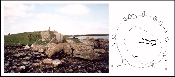
Sig More is the most northerly cairn on South Uist, situated on a small islet off the north coast of the island. It is located on a bedrock ridge on the beach, which at high tide becomes an island. It is likely, however, that the sea levels were lower in the Neolithic and consequently this cairn may have originally been situated on dry land on the edge of a sea loch. The site has extensive views across the sea to Benbecula but very restricted views to the south. Prominent hills almost exactly mark out the cardinal points to the east, north and south.
Fig. 3. Sig More. Photo looking north-west.
Sig More is a relatively small cairn in comparison with the other cairns on the island with a diameter of only 18 metres. The edge of the cairn is defined by a number of large, now recumbent, orthostats which are fully exposed to the sea. Much of the cairn material has been removed or washed away to the north, but it survives relatively intact to the south. No facade is visible and there is no evidence of a forecourt. Many of the passage and chamber stones survive, suggesting a rather unusual chamber which was possibly divided into two discrete compartments. There is no sign of a backstone and no evidence of a capstone.
© Internet Archaeology
URL: http://intarch.ac.uk/journal/issue8/cummings/sigmore1.html
Last updated: Tue Aug 8 2000