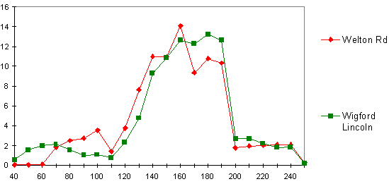
Fig.46: Comparison of samian assemblages from Welton Road, Brough, and Wigford suburb, Lincoln (percentage sherds)
All the samian from the main excavations and from the evaluation trenches has been plotted using the Plotdate program (Tyers 1994). The Plotdate program works from two fields giving the earliest and latest date from a data file, and a count field. The resulting ‘value' (usually sherds) of each record is spread over its range either as the raw ‘value' or converted into percentages. The percentages are essential for comparing assemblages of disparate size. The spread is often used for samian stamps, i.e., the value or percentages for stamp with a date of AD 100-120 is spread over 20 years, with one-half per decade, or a quarter per 5-year span.
The profiles of the groups from the evaluation trenches and the main excavations were plotted for comparison. The small group from the evaluation trenches (only 78 sherds) shows an earlier peak at c.AD 140, and a second peak at c.AD 160 coinciding with the main group from the excavations, and a marginally higher proportion of 1st century sherds. Otherwise there was little difference between the two groups. The profile of all the samian from Welton Road can be usefully compared with that from the Wigford suburb in Lincoln, where the emphasis of the occupation dated to the period from the late 2nd to early 3rd century into the 4th century, Fig.46.
Fig.46: Comparison of samian assemblages from Welton Road, Brough, and Wigford suburb, Lincoln
(percentage sherds)
This shows a peculiarity in the Brough samian, in the decline from c.AD160, whereas the Lincoln Wigford assemblage continues to rise in the later 2nd century. The generally high level of samian at the end of the 2nd century occurs also with the samian from the Lower City at Lincoln, the only area showing a decline being the Upper City (perhaps due to the paucity of excavated samian from occupation at that period). As noted above, however, no very significant decline seems likely before c.AD 190.
The evidence of the samian, and particularly that of the decorated ware and potters' stamps, suggests that there was no abandonment of the site, or reduction in the level of occupation, in either the Hadrianic or Antonine period.
The Welton Road samian can also be compared with that from the excavations 1958-61 directed by Professor Wacher (Wacher 1969), Fig.47. The published lists of stamps and decorated vessels have been converted to a database, and the values, necessarily of vessels, spread. The published dates have been converted to numeric dates; although some adjustment may be needed to the dates in this 1969 report, it is unlikely materially to alter the profile.
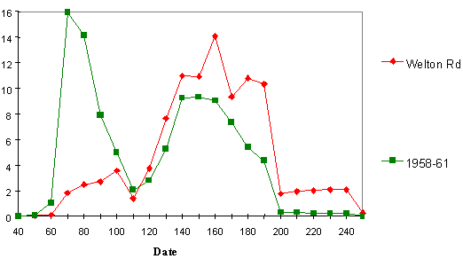
Fig.47: Comparative plotdates of all Welton Road and Brough 1958-61 samian (decorated and
stamps)
This shows a strong peak in the later 1st century, and a secondary broad peak coinciding with the main emphasis of the Welton Road samian. Only 26 stamps were involved, and 123 decorated vessels were published. These are not necessarily representative of the totality of the samian from the site, but the broad coincidence in the 2nd century is of interest. The higher proportion of later 2nd and 3rd century samian from the excavations is also notable.
© Internet Archaeology
URL: http://intarch.ac.uk/journal/issue9/brough/potsam4.html
Last updated: Tue Nov 28 2000