Figure 30
Cut into the Period 3.2 dumps was a large feature lying parallel with the road (1561/2). Only its southern side was observed, but it was at least 1.2m wide by 0.5m deep. This feature could have been a pit, or perhaps a ditch, and probably formed a boundary between the roadside area and the land to the south.
A ditch towards the north end of Trench I (95) could have been the westwards continuation of 1561/2. It was 1.6m wide and 0.6m deep. Its profile was unusual, as the south side of the cut was very steep and slightly convex. There was little evidence of silting due to erosion of the ditch profile, and the dark loamy fill had high stone and pottery contents. This indicates that the ditch was backfilled with waste material not long after it was opened or last cleaned out.

Figure 30
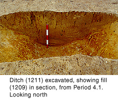
The major Period 3.1 east-west ditch at the south end of Trench 1 was recut (1105, 1211, 1259, 1528, 1596 and 1599) (Fig.30). At around 2.0m wide and 0.8m deep, it was narrower but deeper than its predecessor. In addition, the north-south section continued north for 4.0m beyond the east return before ending as a squared terminal. In Trench I, the probable continuation of this ditch was also recut (151; Fig.17), as was the contemporary ditch to the north (129). East-west ditch 4003 in Trench 4 may have been dug at this time, and appears to have terminated in Trench 3 as 3021; the very small portion of its fill that was excavated (3012) produced a quantity of the locally produced colour-coat wares.
The Period 3.1 ditch 1236/43/44 in the middle of Trench 1 was probably also recut as 1154/1177. It was approximately 1.0m wide by 0.3m deep. Only a short length of this ditch was observed in the western part of the site, but it appears to have continued for at least 20.0m to the east, as 216 in Trench E.
The pottery evidence suggests a late 2nd/early 3rd century date.
A sandy loam dump (1220) was deposited south of feature 1561/2. It was undated.
A large ditch, 2.0m wide and 0.7m deep, ran for at least 8.0m northwards before ending as a gently sloping, rounded terminal (1221/2098). This steep-sided ditch was recut three times in quick succession, presumably because the sandy sides eroded so quickly (1138/1158, 1144 and 1204/2086), before it was finally backfilled with waste and building debris. It is possible that this ditch terminated at an east-west ditch (1150), but if so the latter ditch was not very large and did not continue very far to the east. A narrow ditch lay parallel with, and 4.5m east of, 1121/2098 (1048/1155). Around 10m to the east of 1048/1155 were two narrow ditches (1565-66), perhaps re-cuts of the same feature. These north-south ditches appear to have subdivided the roadside area into several plots perpendicular to the road.
The large pit (2106), which was probably dug to the south of the road in Period 3.1, was now backfilled with dark sandy silt loam (2105). To its south was a small circular cut (2103). It contained small charred bones, ash and charcoal (2100), which may have been a cremation burial.
This phase is thought to represent increased activity alongside the Roman road. Pottery evidence provides an early-mid 3rd century date.
Dumps of sandy loam about 0.25m thick in total sealed the Period 4.3 features, presumably in order to raise the ground level (1035, 1143 and 1183).
A large, aisled timber building was constructed immediately to the north of the main east-west ditch, towards the east side of Trench 1. It incorporated a T-shaped kiln (corn drier) (Building C). A linear post-in-trench feature 7.0m west of the T-shaped kiln was aligned north-south and was at least 11.0m long (1458/1479/1540/1577); it was probably a fence line. This suggests a reversion to property divisions aligned north-south. Several features east of the fence may have been associated with Building C. They were mainly pits (1367-8, 1468, 1473, 1479, 1490, 1499, 1534, and 1580); there was also a shallow cut (1400), which contained a human cremation in a jar (1385).
An insubstantial timber structure was built to the south of the main east-west ditch. Post-pits and slots suggest a building at least 9.0m long (east-west) by 3.0m wide (Building E).
Cut into the Period 3.2 dumps along the western side of Trench 1 were three ditches, aligned east-west. One (1188) was a small ditch, 0.5m wide and 0.3m deep with a concave profile. It was recut as 1189 a little to its north, although it seems to have been recut along the original line further east (1573, unexcavated). A post-pit between the two lines (1190) suggests that a fence ran alongside the ditch.
Further east, probable post-pits and beam slots probably mark the position of a rectangular timber building (Building D). This structure may have been associated with a number of small pits, which were clustered around it on either side. One of the pits (124) contained a human skull and limb bone. Nails situated around the edge of the pit suggest that the incomplete human remains were stored in a wooden box; this may have been a charnel feature.
Immediately to the south was an unexcavated well or watering hole (1593), which appears to have been associated with a small, linear inlet channel to the north-east (1478). A north-south ditch, at least 1.2m wide, in Trench 4 (4002) probably belongs to this phase.
This activity is dated by the pottery to the early 3rd century.

Figure 31
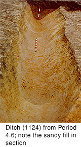
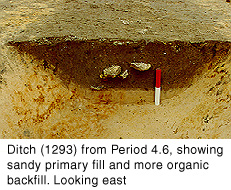
The series of smaller east-west ditches south of the roadside area were abandoned, and replaced with a 1m-wide ditch about 25m from the road (1199/1207). A new north-south ditch, which presumably formed a boundary between roadside plots, was connected to it (1124) (Fig.31). Unusually, this ditch continued southwards from the main east-west ditch (1073-88), forming a cruciform ditch junction. The southern continuation (1293 and 181) was slightly sinuous, and measured 1.0-1.5m wide and 0.4m deep (Fig.32). It cut the Period 4.1 ditches in the middle of Trench 1. The ditch turned north-east before it terminated at a well or soakaway (1170, unexcavated).

Figure 32
The major ditch at the south end of Trench 1 was again recut (Fig.4 ). However, on this occasion the ditch did not incorporate the short northern return, but continued east-north-eastwards, gradually converging with its former line to the north (1049, 1210 and 1526). There was a noticeable gap of up to 5.0m between the ditch and the features to the north; it is possible that this gap marks the position of another boundary feature associated with the ditch, such as a bank or hedge, all trace of which was subsequently removed. In Trench I, the probable continuation of the ditch was recut as 149. This ditch was relatively small, measuring 1.0-1.5m wide and approximately 0.5m deep. It is possible that ditch 4002 in Trench 4 to the south was associated with 149; it did not continue beyond it to the north (Figs.5 and 17).
Extensive sandy dumps (1424 and 1442) were deposited to the west of Building C, sealing the Period 4.2 features. These dumps had evidently been truncated to the west and east by medieval plough furrows.
In Trench K at the south end of the site, immediately east of the Period 1.1 plough marks, was a ditch (98) which was aligned north-south and measured 1.8m wide by 0.8m deep with a concave profile (Fig.19). It probably continued as ditch 135 in Trench L, 36.0m to the north, the fills of which contained 2nd-3rd century pottery. After a period of silting, this ditch was apparently backfilled. It may have been associated with an east-west ditch, which was indicated by a probable (unexcavated) ditch fill (5013) observed during 1994 road construction work a little to the east.
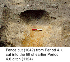
The east-west roadside boundary ditch was replaced with a fence. The posts were set in a narrow trench (1042/1114) cut into the partially infilled ditch (Fig.33). Two post-pits associated with the fence (1072 and 1116) may represent an earlier fence, or mark the position of a gateway 2.7m wide. Subsequently, three small pits containing animal burials were dug along or immediately south of the fence line (1101, 1120 and 1559). Following further infilling of the ditch, post-pit 1072 was replaced with 1086.

Figure 33
Two metres south of the fence line was an east-west alignment of rectilinear cuts at least 4.0m long, separated by gaps of about 1.0m. They were an average of 0.8m wide and 0.45m deep, with vertical sides and a flat base (1025, 1041 and 1262). This alignment was observed a little further east, in Evaluation Trench E (191). The cuts contained a stony fill, which indicates that their function was structural. They appear to form an interrupted east-west feature at least 15.2m long. Circular impressions in the base of the trenches indicate the presence of posts some 150mm in diameter, set in the trenches at roughly 0.5m intervals; this was probably a palisade. Feature 191 was cut by a beam slot immediately to the south (193). Signs of burning in the base of 193 suggest that this timber structure was destroyed by fire. The relationship of these features with the fence line to the north is uncertain.
The low-lying area on the western side of Trench 1 was completely infilled by further dumps of sandy loam, 150mm thick overall (1007, 1010-11, 1033, 1076 and 1147-9). This activity does not appear to have continued as far west as Trench G (fig.3), so it probably filled in a relatively small depression in the ground surface.
© Internet Archaeology
URL: http://intarch.ac.uk/journal/issue9/brough/siterep4.html
Last updated: Tue Nov 28 2000