Figure 28
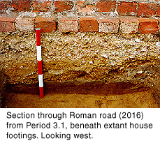
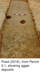
The remains of a Roman road were observed in Trench 2. Although the northern part had been removed by later activity, it survived to a width of 5.0m and appeared to be aligned east-north-east. The road bed comprised layers of sand (2017, 2082-3, 2091, 2101, 2111-14, 2117, 2119-21, 2123-4) which were up to 0.15m thick to the north, but tapered out to the south, thus forming a cambered agger. The area had been de-turfed prior to the construction of the road, as the road bed overlay directly the natural sandy sub-soil.

Figure 28
The road itself consisted of small-medium sandstone pebbles, with occasional small flint and limestone fragments and cobbles, in a sandy matrix (2057, 2062-3, 2071, 2116, 2126-34). These deposits incorporated several layers of iron pan up to 10mm thick, notably towards the south edge of the road, indicating that the road was metalled (Fig.28). The upper layer of small pebbles (2016) formed a very even, cambered road surface (Fig.27). The road body was up to 0.3m thick overall to the north, but tapered out to the south, thus accentuating the surface camber. The surviving profile suggests that the road would have been at least 10.0m wide originally.

Figure 27
This is presumably a segment of the road that ran from the east gate of the walled settlement in an east-north-east direction towards Welton Wold villa and beyond. Pottery recovered from the road deposits suggests a date no earlier than the later 2nd century for its construction.

Figure 29
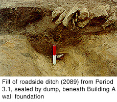
Three metres south of the road was a small ditch 0.7m wide by 0.3m deep, running parallel to the road (2092). This is interpreted as the drainage ditch on the south side of the road. It was subsequently backfilled with silty clay loam (2089) that contained 2nd century pottery, which suggests that the ditch did not remain in use for long (Fig.29). It is thought that pit 2106, immediately south of roadside ditch 2092, was also dug at this time and backfilled later. This pit was 0.5m deep and at least 4.7m wide, and is interpreted as a quarry ditch for the road construction. Some 22m south of the Roman road, the south-west corner of a large (unexcavated) pit was observed (1563). It had been recut as a pit measuring at least 2.9m in diameter by 0.7m deep (1150). The sandy fills (1136 and 1140) appeared to be redeposited natural. The function of these pits is unclear. The absence of identifiable waste in the fills suggests that the pits were not intended for the disposal of rubbish. One possibility is that they were sand quarries, perhaps associated with the construction of the road agger.
The alignment of the boundary ditches to the south was apparently altered at this stage, so that their main axes (east-north-east/west-south-west) were parallel with the newly established road. The most substantial ditch lay towards the south end of Trench 1. To the west, it was 3.0m wide and 0.5m deep, with a concave profile (1129). It then ran north for some 4.0m (1600-1) before returning to an alignment parallel with the road (87; 1373/1548). This ditch was filled with orange sand and the sides showed signs of slumping, which suggests that the cut filled in rapidly due to collapse and erosion of its sides. The presumed westwards continuation of 1129 was found in Trench 3 (3008, unexcavated) and Trench I (76). This ditch, and another 2.5m to the north (133), cut across the possible Period 2.2 defences. Both ditches were recut on more than one occasion, and appear to have remained in use into the 3rd century. 76 was up to 1.0m deep and 2.0m wide. Much of the locally produced colour-coat pottery recovered during the 1991/4 excavations was found in 71, the fill of 76.
Three smaller ditches (1236, 1243 and 1244) were probably the original cut and two adjacent recuts of the same ditch, which ran parallel to, and 20.0m north of, the large ditch. Its probable continuation was observed to the east as a single cut in Trench E (164), and to the west as up to three cuts in Trench G (228, 231 and perhaps 248).
The earliest of the ditches in Trench 4 (4006/8, unexcavated) was probably dug at this stage. It was aligned north-south and seems to have been recut slightly to the west (4007/10). Pottery evidence suggests that this activity took place during the 2nd century.
Dumps of sandy loam sealed the Period 3.1 features south of the road (1060, 1102, 1111 and 1234). Similar dumps at the north end of Trench 2, which directly overlie the natural subsoil, were probably deposited at this stage (2003, 2011-13). The dumps may have been intended to form an even ground surface to either side of the road.
South of the road, the dumps extended into an area of low-lying ground that measured approximately 37.0m long by 11.0m wide, along the western side of the trench (1016, 1083, 1156, 1176, 1178, 1182, 1191-2, 1194, 1202 and 1227). They sealed the Period 3.1 ditches north of a major east-west ditch, 1129. The deposits were up to 0.3m thick to the east but tapered out to the west and did not occur in Trench G, which suggests they were intended to reduce the gradient of the steep eastern edge of the low-lying ground.
On the eastern side of the trench, another group of sandy dump deposits sealed the Period 2.1 features north of the major east-west ditch (1321, 1330, 1392 and 1521). They may have been laid down to form a level surface prior to the construction of Building C in Period 4.5, in which case they are more likely to have been Period 4.4 deposits that contained residual pottery.
The pottery evidence indicates a late 2nd or perhaps early 3rd century date for this activity.
© Internet Archaeology
URL: http://intarch.ac.uk/journal/issue9/brough/siterep3.html
Last updated: Tue Nov 28 2000