Cite this as: Britnell, W.J and Silvester, R.J. 2018 Hillforts and Defended Enclosures of the Welsh Borderland, Internet Archaeology 48. https://doi.org/10.11141/ia.48.7
Hillforts and defended enclosures are among the earliest and most enduring landmarks in the landscape of the Welsh borderland region and are vital to our understanding of its social and economic history for a millennium and a half, from the Late Bronze Age through to the early post-Roman period. Since the modern political map clearly is of no significance for this period, this review — which stems from recent survey and assessment work on hillforts and defended enclosures in central and north-east Wales — takes the opportunity to look across the border and see what is happening in the adjacent areas of England at this time.
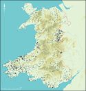
The Welsh borderland region is both ill-defined and topographically diverse. For the purpose of this study it has been subdivided into three areas (Figure 1). The northernmost area corresponds loosely to the Welsh counties of Denbighshire, eastern Conwy, Flintshire and Wrexham and the English county of Cheshire. It takes in part of the north Wales coast and Merseyside, the Vale of Clwyd and the surrounding hills, the northern flanks of the Berwyn Mountains, the Dee valley and the Cheshire Plain. The central area corresponds loosely to north-eastern Powys (the eastern part of the former county of Montgomeryshire) and to western Shropshire. It covers the upper Severn valley, the southern foothills of the Berwyn Mountains, the northern flanks of the Kerry ridgeway and parts of the Shropshire Plain as far as the Ironbridge Gorge. The southern area corresponds largely to southern Powys (the former counties of Radnorshire and Brecknock) and to parts of southern Shropshire and western Herefordshire. It takes in parts of the Usk and Wye valleys and their tributaries, Radnor Forest, the fringes of the Black Mountains, the Brecon Beacons, Mynydd Epynt, the Malvern Hills, Clun Forest, the hills of southern Shropshire and parts of the Herefordshire lowlands.
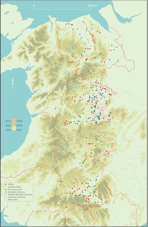
The chief interest of the Welsh borderlands from the point of view of the study of defended settlements has been the marked density of hillfort and defended enclosure sites within a region that spans the divide between uplands and lowlands. The larger and heavily defended hillforts are the more obvious features in the landscape and have been known about and studied for a century or more. Until recent decades many of the smaller and less heavily defended enclosures have been less susceptible to detection and indeed at this end of the scale new sites continue to come to light on a regular basis. For practical reasons, distribution maps prepared for publication (as Figure 1 in this article), have tended to focus upon hillforts rather than smaller defended enclosures (see for example the distribution maps given in Musson 1991, fig. 1; Lynch et al. 2000, fig. 4.1; Koch 2007). The main impression that emerges from the overall distribution is of a clustering of larger forts of over 6 hectares in the Clwydian Hills near the north coast of Wales and more sporadically in the English border counties drained by the river systems of the Wye and Severn. Medium-sized hillforts, with internal areas greater than 1.2 hectares, are spread more widely across both English and Welsh counties, populating the higher ground around valleys such as the upper Usk in Breconshire, and the upper Dee in Denbighshire. A similar pattern is apparent for the smaller hillforts of under 1.2 hectares, though most maps are highly selective in what is plotted within this group. Regardless of size, the density westwards peters out towards the central spine of Wales, which clearly has significance in terms of the social and economic history of the region.
The upper Severn valley in the central part of the borderland region stands out as an area combining a high density of both hillforts and smaller defended enclosures, which have also been a particular focus of modern excavation and research and consequently a fuller interpretative narrative is presented for this region. The focus of attention in the northern and southern parts of the borderland is upon the forms and distribution of monuments that occur in these areas and upon the ways in which these sites might differ from the model proposed for the upper Severn valley. This dichotomy is as true today as when this article was prepared in 2009. There have been new discoveries, with LiDAR playing a significant role and some recent publications have added to the picture, but the overall picture remains much the same as it did then and partly for this reason no major updating of this article has been undertaken.
Topographically, the upper Severn valley, in and around the headwaters of Britain's longest river, splits naturally into two halves, the one more upland and the other more lowland in character. The tributaries of the Severn rise in the west among the peaks of the Berwyn and Cambrian Mountains at over 800m above sea level. By the time its meandering channel passes through the eastern side of our area it has plunged to under 50m.
The region includes many hillforts and smaller enclosures of Iron Age or Roman type (published sources for hillfort and enclosure sites in the region include the following: Silvester and Britnell 1993; Gaffney and White 2007; Hogg 1979; Spurgeon 1972). In general terms these discrete enclosed settlements are characteristic of the pattern of rural settlement across a broad swathe of western Britain, from south-west England, through Wales and the borderlands to the north-west (Taylor 2007, 30, fig. 4.6). In some respects, however, it is quite unlike anything else in the Marches, notably in the juxtaposition of so many hillforts and enclosures, the presence of one of the earliest (Breiddin) and one of the largest (Llanymynech) British hillforts, the clusters of temporary Roman camps, the network of auxiliary forts retained in part until the 3rd to 4th century AD, and the legionary fortress of Wroxeter (subsequently redeveloped as Roman Britain's fourth largest town). The topographical differences of the two halves of the region, combined with significant divergences in their histories following the Roman conquest, provides an ideal opportunity to test ideas about the origin and development of enclosed settlement in western Britain during the later prehistoric period, the interrelationships of upland and lowland economies, and the impact of the Roman world upon Iron Age society.
In terms of tangible criteria such as the types of settlement that people lived in, and their preference for wood rather than pottery (Britnell and Earwood 1991, 170), the region appears to have been culturally fairly homogeneous before the Roman conquest. The dividing line between the western and eastern halves of the region had nonetheless formed a frontier since at least the mid-1st century BC, when it marked the tribal boundary between the Ordovices in the west and Cornovii in the east. In the Roman period this became the dividing line between the 'military' and 'civilian' zones in the province of Britannia. In the early medieval period Offa's Dyke followed a similar course, defining the emerging indigenous kingdom of Powys and the expansionist Anglo-Saxon kingdom of Mercia. After the middle ages it became the boundary between England and Wales.
Despite these political, cultural and linguistic differences the upland and lowland parts of the region have been economically dependent upon each other for many centuries, if not millennia. The uplands above c. 300m have provided extensive rough grazing for livestock during the summer, much of which survived as unenclosed common until about the early 19th century. The more broken and dissected landscapes around the upland fringe, between about 300–100m above sea level, have provided pockets of cultivable land and improved pasture and meadow, anciently cleared and enclosed, within easy reach of the upland commons. The flatter and lower-lying land below about 100m and above the floodplain imposed fewer limitations upon the exploitation of arable and pasture other than those imposed by soil fertility, drainage and aspect. The extensive floodplain of the Severn and its major tributaries, much of which survived as unenclosed lowland common well into modern times, has been an important source of summer meadow and winter pasture.
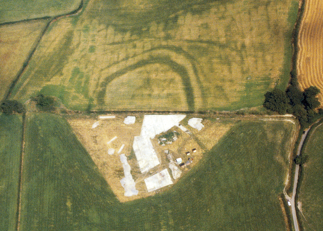
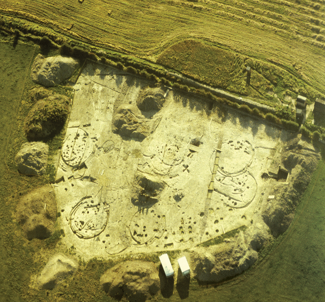
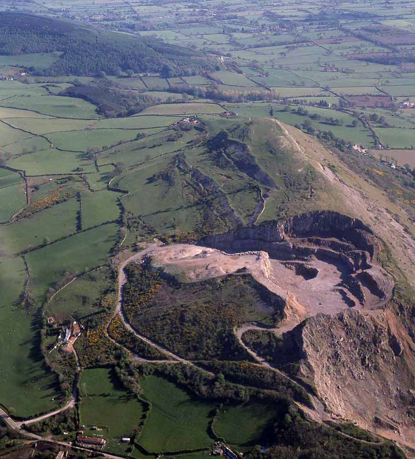
Until the 1960s the focus of attention was almost exclusively upon visible earthwork monuments. Many were surveyed and a small number were excavated, such as the Breiddin, Ffridd Faldwyn, Old Oswestry (Figure 6), and Wrekin hillforts and the smaller enclosure at New Pieces Camp (for the Breiddin and New Pieces see O'Neil 1937; for Ffridd Faldwyn see O'Neil 1942; for Old Oswestry see Hughes 1994; for the Wrekin see Kenyon 1942). From the 1960s onwards aerial photography has played a vital role in identifying a considerable number of new sites, particularly smaller enclosures, and including some monument types that had not survived as earthworks. New sites continue to come to light on a regular basis. These new discoveries inspired a number of more holistic studies, which looked at the shape and size of both the hillforts and the smaller enclosures, their location within the landscape, and how they compared with similar sites elsewhere in Britain (see Whimster 1989; Collens 1988). Since the 1970s rescue excavations of varying scale have been carried out at a number of individual sites, including the Llanymynech and Llwyn Bryn-dinas hillforts, again at the Wrekin and the Breiddin, as well as on an increasing number of smaller enclosure sites, such as Collfryn (Figure 3), Arddleen, Sharpstones, Preston Farm and Calcott Farm (for the Wrekin see Stanford 1984; for the Breiddin see Musson 1991; for Llanymymech see Musson and Northover 1989; for Llwyn Bryn-dinas see Musson et al. 1992; for Collfryn see W.J. Britnell 1989; for Arddleen see Grant 2004; for Sharpstones see Barker et al. 1991; for Preston Farm and Calcott Farm see Jones 1994). Other recent studies have focused on conservation and management issues and the interrelationship of sites within the landscape, some of which have involved geophysical survey, trial excavation and the analysis of finds scatters (for the Montgomeryshire Small Enclosures Project see Silvester and Britnell 1993; for the Wroxeter Hinterland Project see Gaffney and White 2007). Digital terrain modelling, viewshed analysis and virtual reality simulation have opened up other more recent avenues of potential research (Mathews 2006; see http://www.cpat.org.uk/vr/powys/index.htm for an online virtual reality model of the Cefn Carnedd hillfort). At present, however, there is still little other information beyond shape, size and location for perhaps 90 per cent of the known hillforts and enclosures within the region.
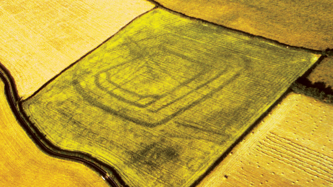
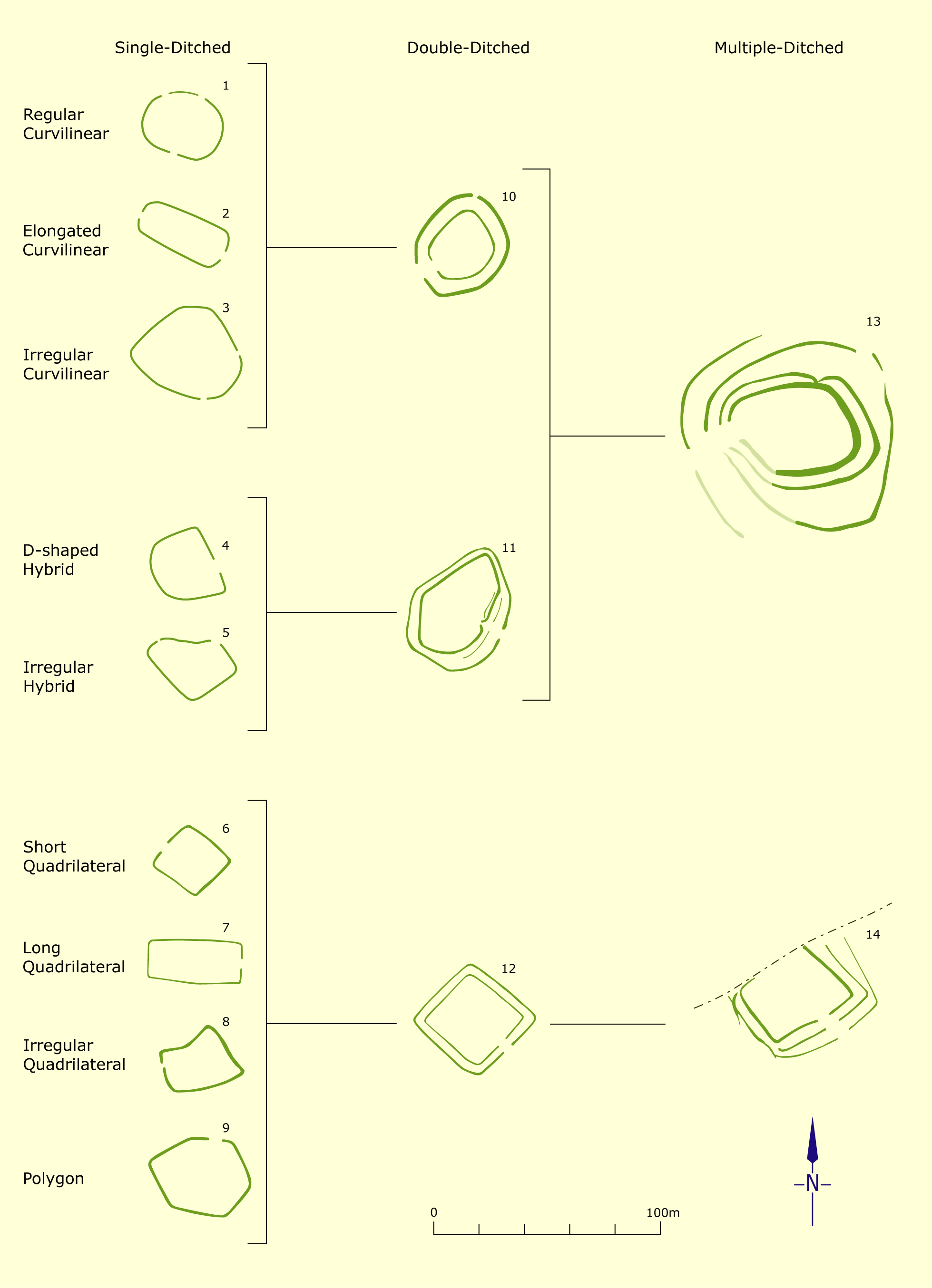
The question of what is meant by 'hillfort' and 'enclosure' in the regional context has been hotly debated. At one extreme are large enclosures in defensive hilltop locations, exceptionally up to 56 hectares in extent and defined by substantial banks and ditches that there is no hesitation in calling a 'hillfort'. Likewise, at the other extreme are small valley-bottom cropmark 'enclosures' of no more than 0.05 hectare, with no surviving banks (Figure 4). Between the two, however, lie a broad spectrum of sizes, defensive capabilities and shapes — irregular, curvilinear or rectangular (though none of the hillforts are strictly rectangular) — within which the distinction between hillfort and enclosure sometimes becomes blurred. Morphological classification is valuable in showing the range of site types that are present (see Figure 2) but inevitably obscures the sometimes dramatic changes that were made to the defences of individual sites over time, as banks and ditches were added or fell into decay, resulting in enlargements or reductions to the areas enclosed. The defences of some sites, such as the undated Dinas hillfort near Llanidloes and a large ditched enclosure near Caersws (the latter dating to perhaps the 4th or 5th century BC), also appear to have been left unfinished (for Dinas see Spurgeon 1972, 338–9; for the enclosure near Caersws see Jones 1991; 1992). An additional uncertainty is introduced by sites that began life as palisaded enclosures, as suggested by a double palisade of spaced posts at Ffridd Faldwyn and a continuous palisade trench at Old Oswestry (for Ffridd Faldwyn see Guilbert 1981b; for Old Oswestry see Hughes 1994, 55). Timber structures of this kind are rarely identified without excavation (e.g. Gelli Dywyll enclosure near Caersws and Llys Farm enclosure near Llanfechain: see Silvester and Britnell 1993, 16).
The great majority of sites occupy the middle ground both in terms of size and topography: these are enclosures with one or more banks and ditches having internal areas between 0.05 and 2 hectares. The curvilinear forms merge into what can be classed as smaller hillforts in more defensive locations, in the 1–2 hectare range. There are a few larger hillforts at the higher end of the scale, again with one or more banks and ditches, all of which tend to be sited in more marginal locations: in terms of size these split into a higher proportion with internal areas of between about 2–8 hectares (such as Cefn Carnedd, Ffridd Faldwyn, the Wrekin and Old Oswestry), and a handful of much larger sites (such as Dinas, Craig Rhiwarth, the Breiddin and Llanymynech), between 12–56 hectares in extent. Following the regional trend, at least 75 per cent of all enclosed sites have internal areas of less than 0.5 hectare and at least 95 per cent have internal areas of less than 1 hectare (e.g. Figure 5). The approximate ratio of very large hillforts, to small hillforts and enclosures in the region is probably in the order of 1:5:30, though the likelihood is that the proportion of enclosure sites is underrepresented. (Figures quoted in this paragraph are taken from the survey of Montgomeryshire enclosures: see Silvester and Britnell 1993.)
A provisional chronology for the development of enclosed settlements in the upper Severn is suggested by evidence from the relatively small number of excavated sites. Recent excavations at Lower Luggy near Berriew have shown that some single-ditched enclosures in the region date to the early to middle Neolithic period. There are uncertainties about whether sites of this kind were domestic or if they fulfilled some other function: the ditch at Lower Luggy is not of defensive proportions (Gibson 2006). A proportion of at least the larger and medium-sized hillforts (such as the Breiddin, Llwyn Bryn-dinas and possibly Old Oswestry (Figure 6) and Ffridd Faldwyn) were newly built in the Late Bronze Age and Early Iron Age, between about 1100–600 BC, often on sites that had seen earlier phases of Neolithic to earlier Bronze Age activity, though too few sites have been excavated to be certain whether smaller defended enclosures may also have appeared during this period. During the middle Iron Age, between 500–100 BC, there was a proliferation of small curvilinear and sub-rectangular enclosures such as Arddleen and Preston Farm (Figure 3) and perhaps also of smaller hillforts. Some existing hillforts dwindled in significance or were abandoned in the later Iron Age, between 100 BC and AD 50. Hillforts ceased to be important as nucleated settlements following the Roman conquest, though some existing enclosures such as Collfryn and Sharpstones continued in occupation throughout the Roman period. Some new enclosures were also constructed during the Roman period, including some rectangular forms such as the Forden enclosure. The defences of these later or remodelled enclosures generally became slighter, possibly reflecting a transition to more peaceful times. (It is notable, however, that none of the strictly rectangular sites have survived as earthworks, suggesting that the boundaries of this class of monument were always less substantial.) A number of smaller enclosure sites, such as New Pieces Camp, continued in occupation or were reoccupied in the early post-Roman period, in about the 5th to 6th century AD (Musson 1991, 194). Finally, some enclosures, such as Old Mills Moat and possibly Llys Farm, may well have originated in the early medieval period (Musson and Spurgeon 1988, 104; Silvester and Britnell 1993, 16).
The defended enclosures in the region seem to owe their origin to the environmental disasters that struck at the end of the second millennium BC (Davies and Lynch 2000, 150). During the relatively favourable climatic conditions that prevailed during the preceding 1,500 years — corresponding with the Neolithic and Early and Middle Bronze Age periods — there had been a steady and unprecedented phase of clearance and land use stretching from valley floor to hill-slopes and mountain top around the upper Severn (Gibson 2002). Ceremonial centres are suggested by concentrations of funerary and ritual monuments (e.g. Warrilow et al. 1986 for Four Crosses, Gibson 1994 for Sarn-y-bryn-caled south of Welshpool; and Gibson 1995 for Dyffryn Lane, Berriew), but the general topographical distribution of sites suggests a widely dispersed population adopting a mixed arable and pastoral economy with perhaps a greater emphasis on the latter around the upland margins. (A dispersed and non-defensive pattern of settlement helps to explain why so few settlement sites of this period are known: it is entirely in keeping with this interpretation that one of the few known settlement sites of the period in the region— the Middle Bronze Age roundhouse dating to 1400–1170 BC, found by chance in the Severn valley at Glanfeinion—was unenclosed: Britnell et al. 1997.)
Deforestation led inexorably to increased run-off, declining soil fertility and changes in hydrology; these factors, it is argued, combined with the change to a cooler, wetter climate towards the end of the second millennium BC, resulted in the dislocation of settlement patterns and competition for resources that would have been particularly acute at pressure points around the fringes of the uplands. These crises were the likely catalyst for the proliferation of weapons and the emergence of defended settlements in the region at this period, which in turn also hint at the presence of a local warrior aristocracy who were able to control resources. Weapon hoards make their first marked appearance in the upper Severn region in the Late Bronze Age, between about 1200–1100 BC, dramatically illustrated by the large weapon hoard found, possibly significantly, close to the defences of the small hillfort at Crowther's Coppice (Davies 1967). An early association between bronze metallurgy and defended settlements may also be indicated by the presence of Late Bronze Age metalworking inside the Breiddin hillfort and by the proximity of seams of copper ore to the Llanymynech and Craig Rhiwarth hillforts (Britnell 1992, 282; Northover 1984, 143).
A comparison between the histories of neighbouring and extensively excavated sites such as the Collfryn enclosure and the Breiddin hillfort (see Where is everybody? Relationships between hillforts and enclosures in the upper Severn valley) stresses the complementary functions of hillforts and enclosures but leaves many questions unanswered. Like the smaller enclosures, hillforts clearly define a space within the landscape set aside for particular social, economic or cultural purposes, but what were these purposes? Were they occupied throughout the year or only seasonally? Were they only occupied at times of crisis? Did some simply fail to become established as proto-urban centres? It can be argued that their archaeologies are so variable that there can be no single answer. A common factor, however, is the coordinated effort needed to build a hillfort, which clearly points to power and authority in the hands of tribal leaders and their retinue. The military aspect of hillforts within the region seems to be borne out by occasional suggestions of hostilities represented by the burning of the Late Bronze Age rampart at the Breiddin and the Iron Age ramparts at Ffrith Faldwyn and the Wrekin, but were they as much for show as for defence (Musson 1991, 177; Guilbert 1981b; Stanford 1984; cf. Armit 2007, 36)? A number of the larger hillforts certainly adopted locations that were visually dominant in the landscape and there are suggestions that the intervisibility of hillforts may have played a role in shaping tribal consciousness in the borderland during the Iron Age (Mathews 2006). Evidence for the intensive occupation of some hillforts at the time of the Roman conquest is slight, and is not hinted at, for example, in the long sequence of radiocarbon dates from the defences or from domestic structures at the Breiddin hillfort (Musson 1991, 180).
An assault by the Roman army at the Wrekin is demonstrated by the presence of javelin heads and by evidence of burning (White and Webster 1994), but the status of occupation at this period is less certain. The closest we come to a first-hand account of a hillfort in Wales and the borderland is given in Tacitus's surprisingly full account of the stand made against the Roman army by Caractacus with local support somewhere in Ordovician territory in AD 51, when stones were piled up to serve as a rough barrier (rudes et informes saxorum compages) (Fisher 1906, Book 12, 33–5). The site of this battle is still unknown, though various hillforts in the upper Severn region such as Cefn Carnedd, the Breiddin and Llanymynech have been suggested by trying to reconcile the topographical details provided by Tacitus. Tacitus's description implies that the site of the battle was on a steep hill (montibus arduis), which only needed artificial defences where the slopes were less steep (si qua clementer accedi poterant). In front ran a river of varying depth (praefluebat amnis vado incerto): Fisher 1906, Book 12, 33. Caution must be shown in taking this account too literally, but rather than describing anything we might recognise as a fortified town, the overwhelming image from the very end of the Iron Age is simply of a barrier, hastily constructed in a naturally defensible position by an elite group of warriors comprising chiefs (gentium ductores) and their clansmen (gentili).
We seem on firmer ground in assuming that enclosures were occupied by smaller kinship groups, and here there are also perhaps stronger grounds for assuming that they were permanently occupied and firmly embedded within the local agricultural economy. There are similar uncertainties about the extent to which their banks and ditches were for defence, display or some practical consideration. There are some aspects of sites such as Collfryn, such as the apparently disproportionate length of the defences to the manpower likely to have been available within the settlement itself, which hint that we are again dealing with an elite group with control of wider resources (Britnell 1989, 110). This clearly begs the question of the extent to which hillforts and enclosures between them represent the whole of Iron Age society, or whether there was an underclass, otherwise largely unrepresented in the archaeological record, which rendered labour services. Hillforts and enclosures may have accommodated such a tier of society, though some or indeed many of its number may alternatively have occupied open settlements that by their very nature are less visible within the landscape. Practically the only traces of Iron Age activity outside enclosed settlements have been found by chance during the excavation of sites of other periods, as in the case of Early Bronze Age funerary and ritual monuments in the upper Severn valley at Four Crosses and at Sarn-y-bryn-caled (Warrilow et al. 1986, 85; Gibson 1994, 156). It may be significant that these particular examples are both associated with metalworking but this appears to mirror a pattern also reflected in the region during the Roman period, which suggests that the low incidence of unenclosed settlement is probably more an index of recent archaeological activity than a reflection of Iron Age and Roman patterns of settlement (cf. Taylor 2007, 48).
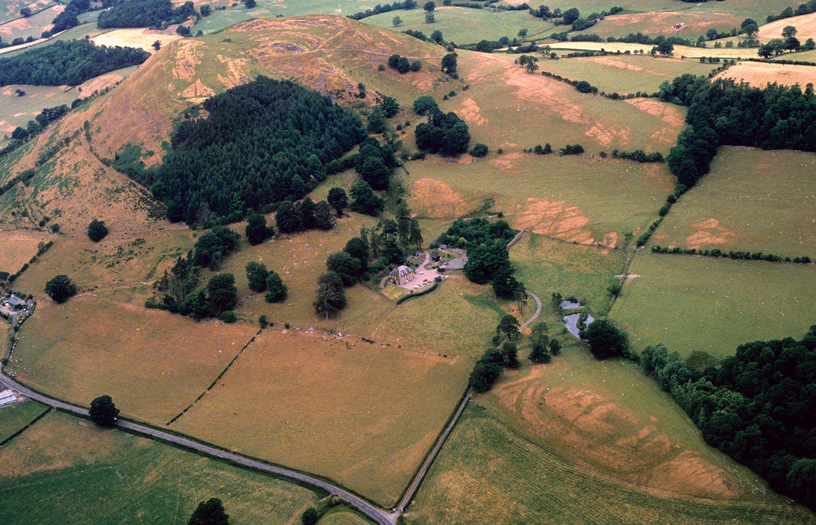
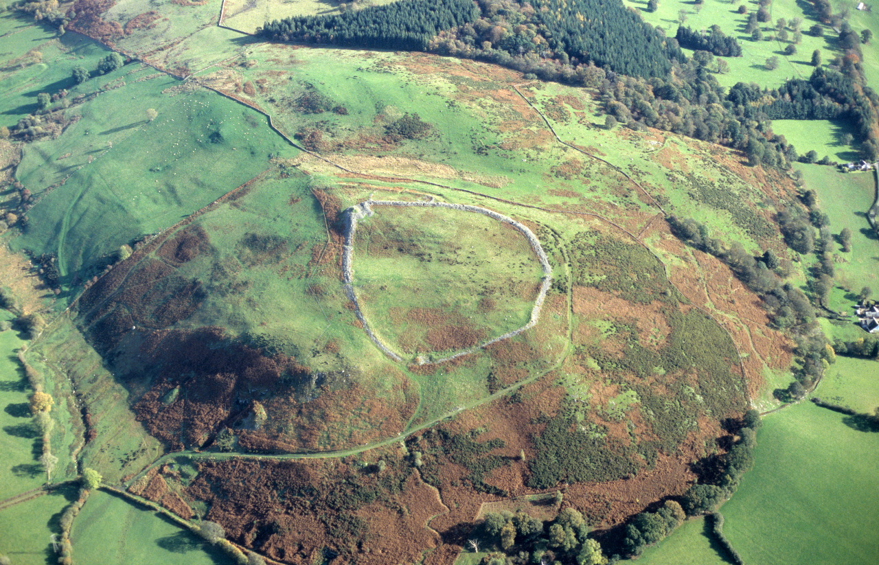
As well as the clustering of defended enclosures in some areas, which in parts of the area around Montgomery achieve a density not dissimilar to that of 19th-century farms, there are also some notable pairings of hillforts and smaller enclosures in some instances. Clear examples of this are evident at Great Cloddiau on the Kerry ridge where a large, single banked hillfort and a sub-rectangular double-ditched enclosure lie within a few hundred metres of each other. Likewise a much smaller enclosure at Plas Uchaf lies at the foot of the prominent hill in the Tanat Valley upon which the hillfort of Llwyn Bryn-dinas is sited (see Figure 7). The pairing of sites is reminiscent of the way in which medieval motte and bailey castles within the region were often superseded by later estates and country houses but as yet there is insufficient dating evidence to tell whether a continuity of land holdings from the inhabitants of the hillforts to those of the enclosure is similarly indicated.
A vital perspective on Iron Age social institutions in the upper Severn valley is provided by the divergent histories of the tribal territories of the Cornovii and Ordovices following the Roman conquest. The upper Severn had been conquered by about AD 50/55, during the governorship of Ostorius Scapula, when the legionary fortress replaced an earlier fort at Wroxeter. In front lay a chain of auxiliary forts, at Brompton, Forden and Caersws (Davies 2007), whose general disposition is no doubt as much a reflection of the strategic significance of the Severn valley corridor as of the Iron Age population at the time of the conquest. Conditions remained unsettled in western parts of the region and other remoter parts of Wales until after AD 77/78, when a revolt the Ordovices was suppressed during the governorship of Gnaeus Iulius Agricola. This, together with the subsequent assault in Anglesey, was the last campaign by the Roman army in Wales to be considered noteworthy by Roman commentators. The Cornovii, by contrast, appear to have offered little resistance to the Roman army and there are even hints that a unit raised within the tribe was stationed at Caersws in the later 1st or early 2nd century AD (Jarrett 1969, 181; Birley 1952, 15). Among other factors, the delay of a generation in pacifying Ordovician territory had given the Cornovii a head start in exploiting the new economic opportunities that presented themselves at the time of the Roman conquest.
The early fort and subsequent fortress at Wroxeter, and the forts at Brompton, Forden Gaer and Caersws, followed the familiar pattern of attracting civilian settlements (for Brompton see Frere and Tomlin 1991, 247; for Forden see Blockley 1990; for Caersws see Jones 1993). In the case of Caersws, for example, the settlement was up to about 7 hectares in extent, housing typical Roman timber strip buildings representing taverns, shops and metalworking and leather workshops (J.E. Britnell 1989). At an early stage these settlements were clearly inhabited by incoming artisans and merchants providing goods and services for the military and probably had little direct impact, either commercially or culturally, upon the indigenous population. Some displacement of the local population is likely to have taken place as land was requisitioned by the army for the construction of forts and the roads linking them, but the evidence appears to suggest that the effect was quite muted. (Geophysical evidence suggesting earlier enclosures underlying the Roman town of Wroxeter is one of the few possible instances of a spatial conflict between native sites and Roman military installations: see White, Gaffney and Gaffney 2013) There is equally little evidence for the widespread or lasting abandonment of smaller enclosed settlements, though the hillforts, as noted above, had waned in significance at or well before the time of the conquest.
By AD 90 the legionary base had been moved northwards from Wroxeter to Chester. About 78 hectares of land formerly occupied by the fortress and its territorium and even some of the military buildings inside the fortress were made over to the tribal authorities for the foundation of Viroconium, the administrative capital of the Cornovii (White and Barker 1998). There is striking new evidence that much of the town's importance derived from its role as a regional livestock market and centre for the tanning industry (Gaffney and White 2007, 283), an activity that was no doubt given a kick-start by the demands of the military personnel concentrated in the Wroxeter area. It is argued that tribal leadership of the Cornovii played a pivotal role in negotiating the creation of the urban spaces essential to the exploitation of these commercial opportunities, which in turn encouraged native farms in the town's hinterland to effect the transition to a market-orientated economy. The cluster of high-status villas encircling the town also appear to relate to a mercantile class based within the town, rather than a flowering of 'Romanization' in the countryside around it. The Whitley Grange villa, for example, may represent a hunting lodge rather than a permanent residence or farmstead (Gaffney and White 2007, 278).
The post-conquest history of the western half of the region was radically different. The continuing presence of tribal leaders among the Ordovices is hinted at by the probable rich burial deposit of later 1st- or 2nd-century date found at Welshpool, including an iron firedog, iron candelabra, glass and pottery, bronze paterae, ewer and cauldron. The finds also include a wooden bucket (or milk-pail?) with a bronze handle mount in the form of a cow or bull's head, which fuses native and Roman cultural traditions (Boon 1961). The auxiliary forts in Ordovician territory at Forden Gaer and Caersws continued to be fully garrisoned up to about AD 130, for a generation after the army departed from Wroxeter. Thereafter, there is evidence of continuous or intermittent activity on a much-reduced basis extending into the 3rd and 4th centuries, suggesting that they continued to fulfil an administrative role long after their overtly military function had ceased. The flourishing activity in the vici associated with these forts likewise tailed off in the early decades of the 2nd century and although they failed to develop as industrial centres it seems likely that they survived as the only small-scale nucleated settlements and lesser commercial centres in the western part of the region into the 3rd and 4th centuries. There are clear suggestions that the indigenous population in this western part of the region lacked the critical mass to compete with Wroxeter, which had already stolen a march by becoming the region's focus of commercial activity.
Like the medieval border towns that eventually supplanted it, Wroxeter's hinterland probably extended to include many of the hill farms in the west whose produce was driven to market on the hoof, and which in addition to cattle may also have included the ponies and horses for which the western part of the region was once renowned (Moore-Colyer 1991, 130–1). There is evidence for the expansion of pastoralism during the Roman period, including continued pressure on the uplands around the upper Severn (cf. Walker 1992) and the rash of smaller, rectangular, single-ditched enclosures that appear in low-lying valley bottoms. These are sometimes in proximity to Roman forts or Roman nucleated settlements and have the general appearance of colonising former unenclosed lowland meadows (cf. Collens 1988, 319–22; Whimster 1989, 45; Gaffney and White 2007, 256, 274). The relative scarcity of finds on Roman rural sites within the region is undoubtedly a cultural trait inherited from earlier times (Gaffney and White 2007, 280). There seems no reason to doubt that the inhabitants of many of the rural Roman farmsteads within the region, like the Iron Age farmers to whom they were heir, were culturally more sophisticated than appearances might suggest. What other explanation is there for the two Roman styli and fragments of early post-Roman glass from the remote hilltop enclosure at New Pieces, close to the abandoned ramparts of the Breiddin hillfort (O'Neil 1937, 121, fig. 8; Musson 1991, 194, fig. 76)?
The hills of Brecknock and Radnorshire in southern Powys spread north-eastwards into Clun Forest and the Shropshire Hills, and eastwards they give way to Herefordshire, a county that provides a lowland counterbalance to the adjacent Welsh hills and may, as we shall see, hold some significance for the settlement pattern of the late prehistoric era (Figure 1).
Iron Age and later settlement in southern Powys is demonstrated by nearly 140 defended enclosures. These display considerable variation in form as well as location, although most are relatively small, only two hillforts having internal areas in excess of 5 hectares. However, the distribution of all defended enclosures across the western part of the region is far from even. There are obvious concentrations, for instance in and around the Usk valley, and up the Wye close to Builth Wells. Some upland areas such as the Brecon Beacons and the Black Mountains appear to have been deliberately avoided, and the central moorland core of Mynydd Epynt is devoid of sites, though small Iron Age enclosures are now being distinguished on its fringes (Silvester 2008, 12). These mountainous areas were too extensive and remote to be attractive to Iron Age communities, and though defended enclosures may have been a necessary requisite for settlement, the communities did not move significant distances into the uplands to construct them. In the less extreme conditions of the northern Radnorshire hills, and more remarkably in the Wye valley where it veers north-eastwards, the apparent sparsity of known sites is more surprising.
Large hillforts are a rarity. Of the two over 5 hectares internally, Burfa Bank on a hill overlooking the Walton Basin would, on its size and the contour-hugging defences, be more in place in the Herefordshire lowlands. Allt yr Esgair, occupying an isolated but prominent hill top immediately to the north of the river Usk, between Brecon and Crickhowell, appears to be this size by dint of the need to enclose the whole of the elongated hilltop, though there are signs that a smaller fort on the highest point of the hill may have preceded it. Another hillfort — Cwm Cefn y Gaer Hillfort in Radnorshire — which at 4.7 hectares is fractionally smaller, is altogether less impressive both in the scale of its defences and in its unimposing hill-top location.
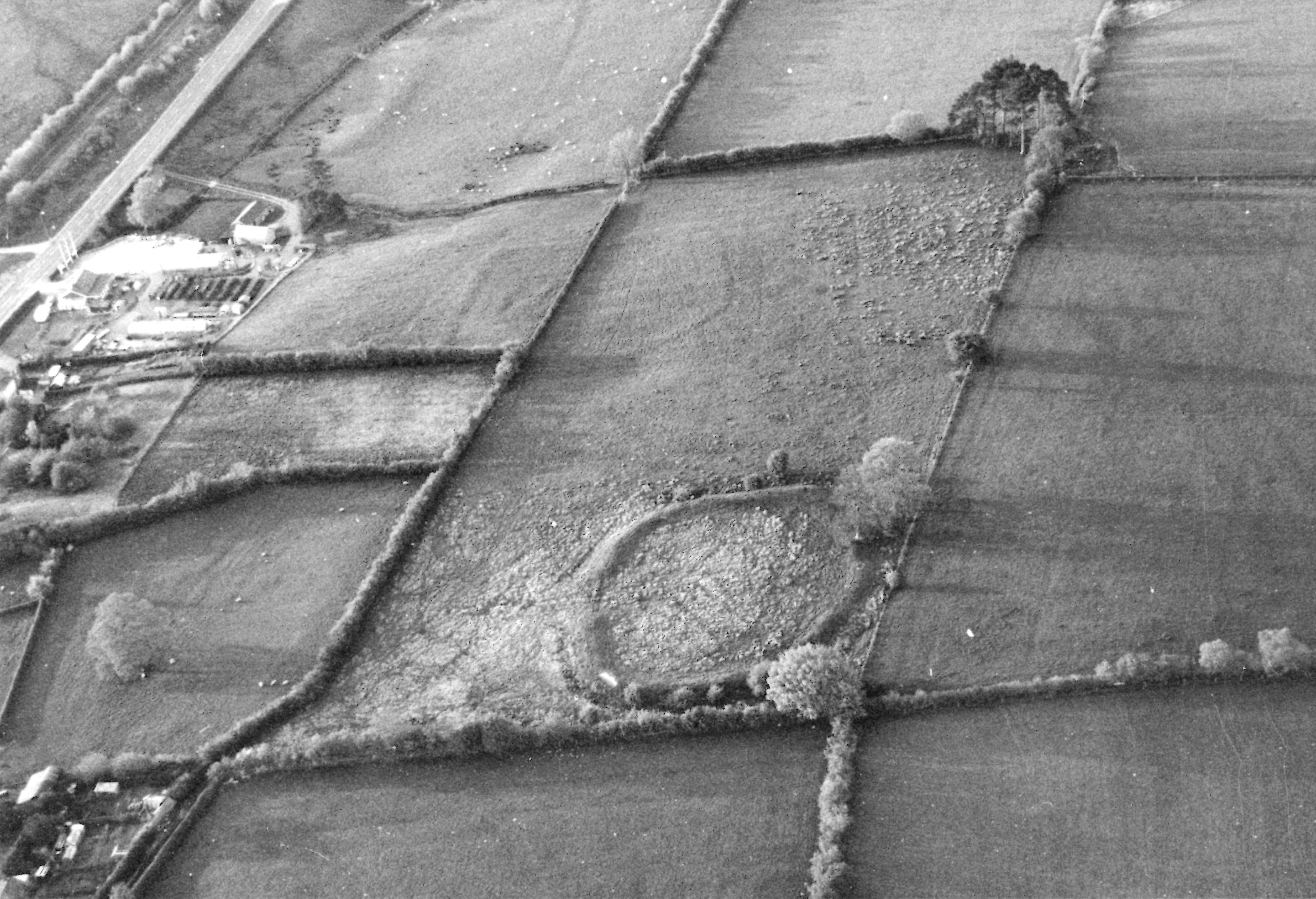
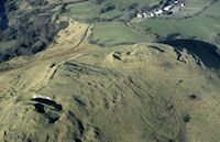
Smaller hillforts are more numerous. In the southern hills around 60 examples are known, and diversity is a key feature of the group. They range in internal area from less than 0.1 to over 4 hectares, but more than half have an internal area of less than 1 hectare. Some, such as Caer Du just to the south of Llandrindod Wells (Rads), have relatively formidable man-made defences (Figure 8), but the builders frequently took the opportunity to utilise natural scarps, or exceptionally steep and unassailable slopes against which to butt their earthworks, as with Wern Camp above Glascwm (Rads), thus saving themselves the labour of further construction. The construction of a single bank and ditch across a steep-sided promontory or spur was an even more extreme labour-saving technique, seen well on the Cnwch Bank enclosure near Llangunllo (Rads) where only a 32m-length of earthwork was thrown up. These sites need to be distinguished from those hillforts that appear to have been deliberately left incomplete, presumably either because the threat that triggered their preliminary construction had passed, or because events overtook them.
A number of these hillforts display outer earthworks of varying form that enclose and protect further areas of ground, sometimes larger than the area of the main enclosure. These multiple-ditched enclosures reflect a tradition that was initially identified in south-west England and in the extreme south of Wales (Fox 1952; 1960), though it is evident that the tradition also spread further north. Cunliffe (2005, 280) has noted that such enclosures were designed more for the convenience of small pastoral communities than for defensive strength, the outer banks being laid out to protect pastures and watering places, and that they display in some areas a preference for sloping ground in upland locations, with outer banks and ditches that are slighter than those of their inner counterparts. Of the eight or so known examples in this part of Wales, Nant Tarthwyni Hillfort II on the eastern side of the Brecon Beacons has a sub-circular inner enclosure accompanied by a more rectilinear outer enclosure whose defences fade out before they reach the lip of the steep valley immediately to the north of the site. Less typical is Llysin Hill in Radnorshire, where a sub-oval hill-top enclosure is accompanied by two earthworks, 80 and 180m away, crossing the rising approach from the east. Neither extends across the full width of the ridge and for these to have been effective barriers they presumably would have had to abut woodland.
Paired hillforts occupying adjacent hills or spaced along a ridge provide grounds for speculation. Were they in use at the same time with the possibility of hostile communities facing each other from behind their ramparts, or were the enclosures occupied successively? On the basis of the variant earthwork forms seen in southern Powys, the latter seems more likely. Adjacent hill tops close to the Ithon valley support the large Cwm Cefn y Gaer Hillfort mentioned above, and around 600m away to the west the more complex earthworks of Gaer Hillfort, which appears to be a multiple-ditched enclosure rather than a multi-phased defensive site. The large, univallate Cwm Cefn y Gaer has the appearance of an early defensive site, while the Gaer should be later, though only extensive excavation on both sites would corroborate this. Further south in Brecknock, a second hillfort, Nant Tarthwyni Hillfort I, lies less than 200m to the south-west of Nant Tarthwyni Hillfort II (see above), but lacks outworks, and has less natural protection from the adjacent valley slopes, again implying that they were constructed at different times.
Spread randomly across the hills of southern Powys and accounting for around 40 per cent of the likely Iron Age and Roman settlement sites in the region are small enclosures almost always encompassed by a single bank and ditch, with a simple break in the circuit functioning as an entrance into the interior. The interiors usually cover no more than 0.4 of a hectare, though occasional examples are of greater size, rising to around 0.8 of a hectare. Most display a distinctively curvilinear outline.
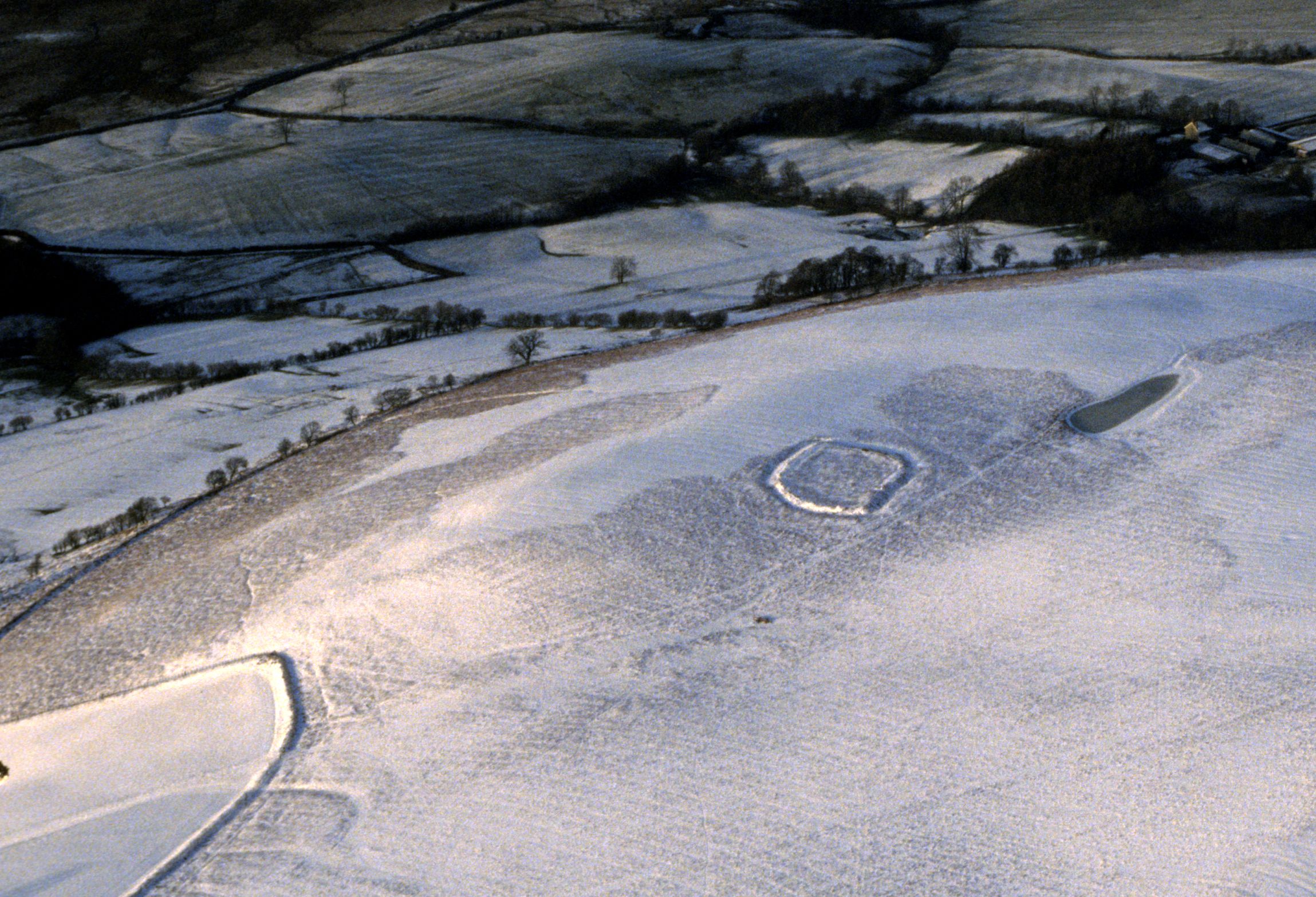
These enclosures are rarely in prominent or overtly defensive locations. Some do occupy hill-tops but usually these are not naturally strong locations. Rather more are set on hill and valley slopes. The Coed Swydd enclosure on one of the Radnorshire Commons, for example, is roughly oval in shape and occupies a slightly raised terrace, with higher ground rising behind it (Figure 9). The location may have been influenced by the outstanding views over the valleys to the west and perhaps, too, by the seemingly natural dewpond immediately to the north of the site, but for its defence it would have had to rely entirely on the earthworks that had been thrown up. Rarely do natural defences appear to have been an overriding factor in siting such enclosures. The Garth enclosure near Nantmel (Rads) is positioned at the end of a narrow ridge that would have provided the only comfortable access to the site, but The Gaer and Wellfield enclosures, both in the hills to the north of Builth Wells, are more typical, for though both are sited on local highpoints there is easy access from several directions.
Few of the hillforts reveal the positions of the roundhouses that were built within them. Even where some appear, as on Castle Bank in south-western Radnorshire with at least eight terraces visible, and two to three in the apparently unfinished ridge-top of Bryn Melyn above the Talybont Reservoir in Brecknock, they probably represent no more than a small proportion of the habitations that existed within the defences. In contrast, although few of the small enclosures reveal traces of house platforms, those that do probably provide a more accurate picture of the number of buildings within them. Glog Hill Camp has two platforms, the Fron Goch enclosure has three, but in Montgomeryshire both Clwt Camp and the Cwm Glog enclosure in Kerry have single platforms, as does the Caeau Enclosure beneath Mynydd Llangorse in Brecknock.
The general size of the enclosures clearly reflects their use by small communities, a single family or perhaps an extended one. They are simply homestead enclosures, with the scale of their earthworks normally commensurate with providing protection for the inhabitants within. They represent the most obvious form of enclosed settlement in the hills, but they were sited for the convenience of their builders, not for defence. That so many were tucked away on hillslopes and spurs suggests a desire to remain inconspicuous. None has been excavated so it can only be conjecture that they are primarily late prehistoric in origin, but some probably continued in use into the succeeding Roman era. They are clearly the eastern equivalent of the more numerous raths and ringforts in the south-west of Wales. Others undoubtedly await recognition in Brecknock and Radnorshire, the barely visible earthworks of sites such as the Dixies Corner enclosure on the edge of Mynydd Epynt demonstrating that degradation through farming and forestry can take its toll of these small sites.
Cropmark enclosures can be seen as the lowland counterparts of the earthwork enclosures in the hills. Those that are known in this part of east Wales normally populate the flatter ground, close to the valley of the Severn in the north, and in the Walton Basin. It is therefore remarkable that further south, in the Usk valley, few cropmarks have been identified in spite of the extensive presence of arable land there. A handful of cropmark enclosures have been recognised in the hills surrounding the Walton Basin. A single-ditched rectilinear enclosure at Cwm Whitton at about 260m above sea level for example, and a double-ditched circular enclosure at Newton Farm a few kilometres to the east and 30m higher in altitude signals the fact that the cropmark enclosures spread out from the Walton Basin into the surrounding hills. Further afield, a rectilinear enclosure above the River Irfon at Llangammarch Wells was recognised as recently as 1995. Romano-British it may be, but it does indicate that even in western Brecknock cropmarks or parchmarks may yet enhance a settlement pattern that currently is very sparse.
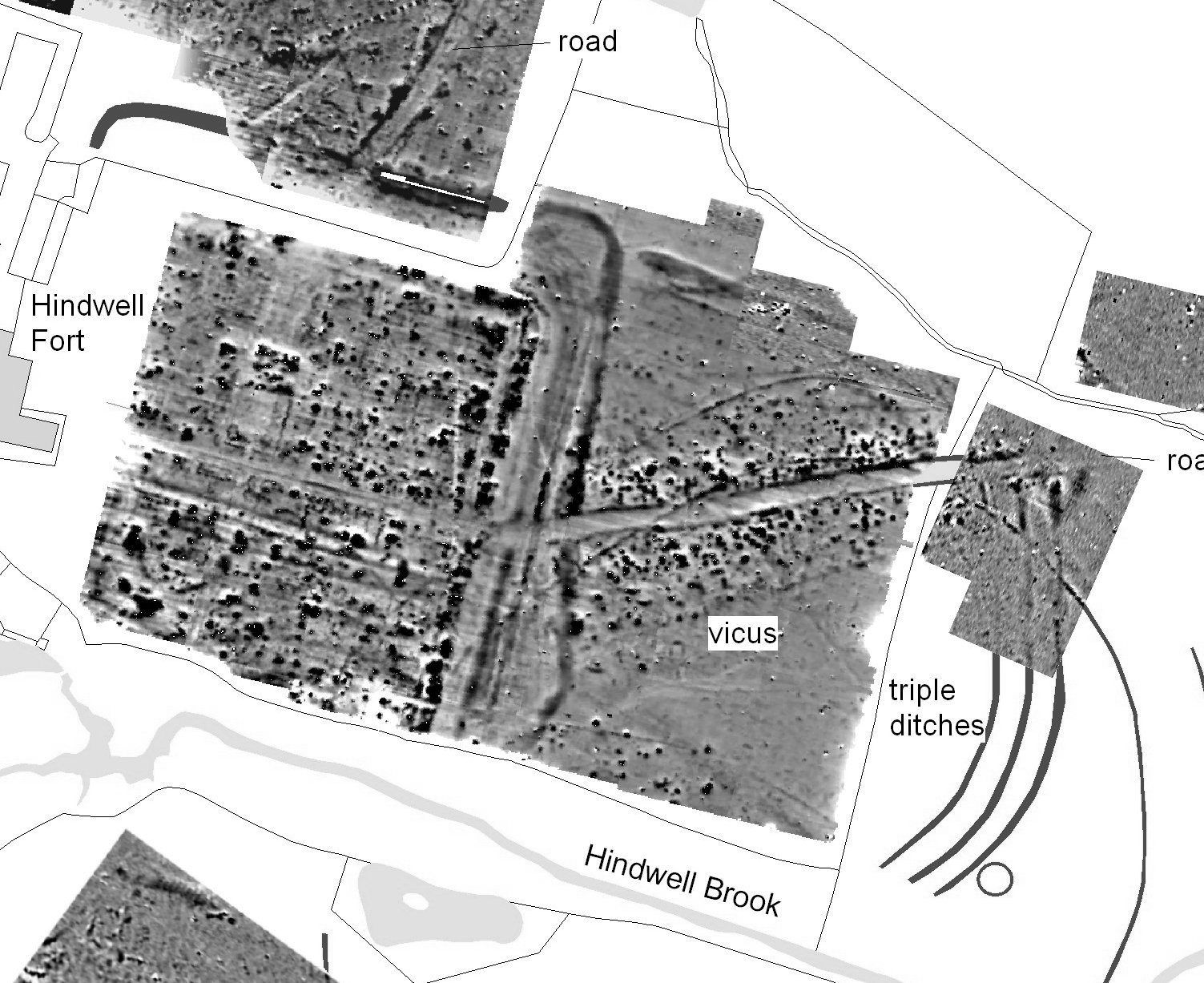
The Walton Basin is exceptional: this low-lying plain carries the Hindwell Brook and its tributaries from New Radnor eastwards to a confluence with the River Lugg beyond Presteigne. Among the remarkable collection of cropmarks representing a Neolithic palisaded enclosure, Bronze Age ring ditches, and a Roman fort and practice camps, are a large number of enclosures, the densest concentration in east Wales, other than some parts of the Severn valley. A programme of limited excavations in the 1990s provided an Iron Age date for the rectangular Hindwell 1 enclosure with its single round hut visible from the air, while the lack of datable material at the rectangular enclosure of Knapp Farm and the oval Rough Close could also favour an Iron Age rather than a later chronology (Gibson 1999a, 10, 25). Two-thirds of the eighteen enclosures currently detected in the Walton Basin are rectilinear and can be assumed to represent defended farmsteads spanning the Iron Age and Roman eras. Curvilinear enclosures that are similar in size as well as form to the earthworks in the hills are, on the other hand, non-existent, although there are one or two that are either smaller or larger in area. There is also a single double-ditched enclosure, its Iron Age origin incontrovertibly demonstrated by its presence beneath both the 1st-century AD Roman fort and the associated vicus at Hindwell (Figure 10) (Gibson 1999b, 49, fig. 24).
The changing topography that distinguishes the undulating countryside of Herefordshire from southern Powys is mirrored in the morphology of its defended enclosures. It is perhaps significant that the forms of defended enclosures in the area as a whole show rather greater coherence north/south than across the region. Another more fundamental difference is that considerably more excavation has been conducted on Iron Age sites in Herefordshire, notably by Stanford at Credenhill, Croft Ambrey and Midsummer Hill (Stanford 1970; 1974; 1981).
Most obvious are the large hillforts, which are more prevalent here than further west. It is not that smaller hillforts are absent, rather that proportionally large hillforts are much more in evidence in the western half of Herefordshire. Croft Ambrey, Brandon, Aconbury, Eaton, Wapley and Ivington all have enclosed areas in excess of 4 hectares, with Sutton Walls to the north of Hereford more than 11 hectares and Credenhill to the west up to 20 hectares (Figure 11). The large forts of central Herefordshire, clustered around the Wye/Lugg confluence, form the most westerly grouping of these large hillforts in the central Marches. Further west only isolated examples are to be found, such as Burfa Bank, the small cluster of Brandon Camp (Adforton), Croft Ambrey and Wapley Hill in north-west Herefordshire, and one or two other smaller forts.
Stanford in the early 1980s felt able to assert that as a result of excavations 'we probably now know more about Welsh border hillforts than about any comparable group in the whole Celtic hillfort province' (Stanford 1980, 79), and while such a view is no longer sustainable, it remains a fact that excavation in the Herefordshire border has been of an altogether different magnitude to that further west. The details about the defences and internal arrangements of those forts that have been partially excavated in Herefordshire are accessible in several publications (Stanford 1970; 1974; 1981; Cunliffe 2005, 399) and here it need only be noted that, without exception, their origins are very early in the Iron Age, perhaps as early as 700 BC. Some, such as Ivington Camp and Croft Ambrey, continued into the 4th century or even the 2nd century BC (White 2002). No comparable picture exists for southern Powys, where excavation has been very limited.
Scarcer in the pantheon of site types are smaller hillforts. Less than ten have been confirmed in western Herefordshire. There is a thin scatter in the south-west, such as Pen Twyn Camp in Brilley and Mouse Castle, Cusop, where a medieval motte utilises a prehistoric earthwork, both of them being under a hectare in internal area, while the promontory fort in Lower Park Wood, Vowchurch, encloses 1.7 hectares, and produced middle Iron Age material.
At the other end of the spectrum are the cropmark enclosures that are now being discovered in Herefordshire in ever increasing numbers. These indicate a landscape that in places was heavily populated from the later Iron Age onwards. Excavation in recent years has begun to provide some dating evidence. The enclosure at Ridgway, Cradley, produced middle Iron Age pottery and Moorcourt Farm near Lyonshall, among others, revealed continuity from the later Iron Age to around AD 200 (White 2002; Guest 2002). In a complex of curvilinear and rectilinear enclosures at Leen Farm near Pembridge, which was crossed by the Rowe Ditch, an early medieval linear earthwork, a distinctively rectangular enclosure, yielded both late Iron Age and Roman pottery (White 2003, 39). The Cold Furrow enclosure, also near Lyonshall, which was abandoned around the beginning of the 3rd century AD, appears to be wholly Roman (Guest 2002). Most of these enclosures appear to be broadly rectilinear in design, and the excavated finds in areas such as the Arrow valley to the west of Leominster, seems to point to both higher and lower status sites. Indeed, it has been argued that the double-ditched enclosure of Upper Headlands at Staunton-on-Arrow to the west of Leominster, occupying a small gravel promontory, was too elaborate for ordinary farming purposes, leading to the suggestion that both inner and outer areas might have had ritual or funerary roles (White 2003, 38). Other, unexcavated, examples such as an enclosure near Vowchurch, have been labelled as Iron Age simply on the basis of their curvilinear shape. Shape, however, is at best an imprecise pointer to date, and it has yet to be established whether curvilinear enclosures follow their rectilinear counterparts in being constructed through the Iron Age and in the subsequent Roman era.
In the distribution of cropmark enclosures, there are denser concentrations in some areas as to the south of Kington and the Arrow valley, around Wigmore in the north-west of the county, and to the west of Hereford around Stretton Sugwas. By contrast there are currently large voids, as around Weobley between Kington and Hereford, where not a single cropmark enclosure has been photographed. Focusing on just the double-ditched enclosures, however, there is a reasonably even spread of about 22 such sites across the western half of Herefordshire, implying a more even spread of enclosures across the whole landscape. It can probably be assumed that the unevenness in distribution is due more to the varying soils and agriculture of the region, coupled with varying programmes of aerial photography, than genuine variations in the distribution of late prehistoric and Roman enclosed farmsteads.
What is uncommon in western Herefordshire is the small earthwork enclosure. An earthwork, about 50m square, on Garway Hill in the extreme south-west has recently proved to be middle Iron Age, while a small oval earthwork in Lord's Wood, Whitchurch, appears to have functioned as a Romano-British farmstead (Neil Rimmington, Herefordshire Council: pers. comm.; Ray 2002). Occasionally, comparable rectilinear sites are identified in earthwork form, as at Wigmore Rolls near Leintwardine and at Yarsop near Hereford, but overall there are few small curvilinear earthwork enclosures, with perhaps less than half-a-dozen examples tentatively identified in western Herefordshire.
North-east Wales, defined here as the historic counties of Denbighshire and Flintshire, offers more variety in its landforms than any other region of the borderland, with high moorlands, rolling hills, coastal lands, wide vales and deep valleys. Perhaps, then, it is not surprising that there is an apparent lack of uniformity or coherence in the known archaeology, and that research, both terrestrial and aerial, has been less consistent than elsewhere. John Manley went so far as to argue that topographically north-east Wales lacked 'a diagnostic, clearly defined small settlement 'personality' in the Iron Age and Romano-British periods to match to those of the other Welsh regions' (Manley 1990, 21).
Perceptions of the Iron Age in north-east Wales have been understandably dominated by the prominent hillforts that crown the Clwydian range, and their size is matched by the substantial literature that is available on them (see references in Brown 2004 for instance). Likewise, in adjacent Cheshire it is the big forts at Eddisbury and Maiden Castle that have tended to be the focus of attention.
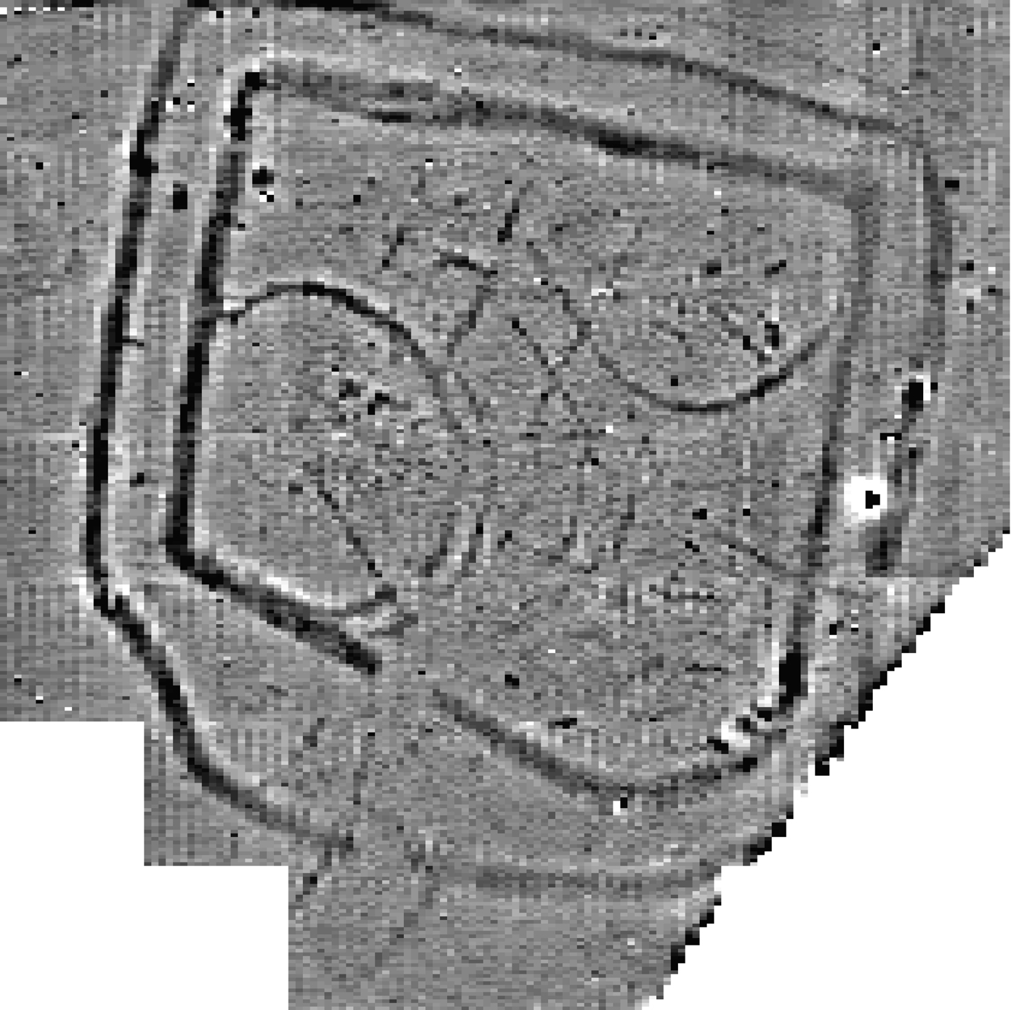
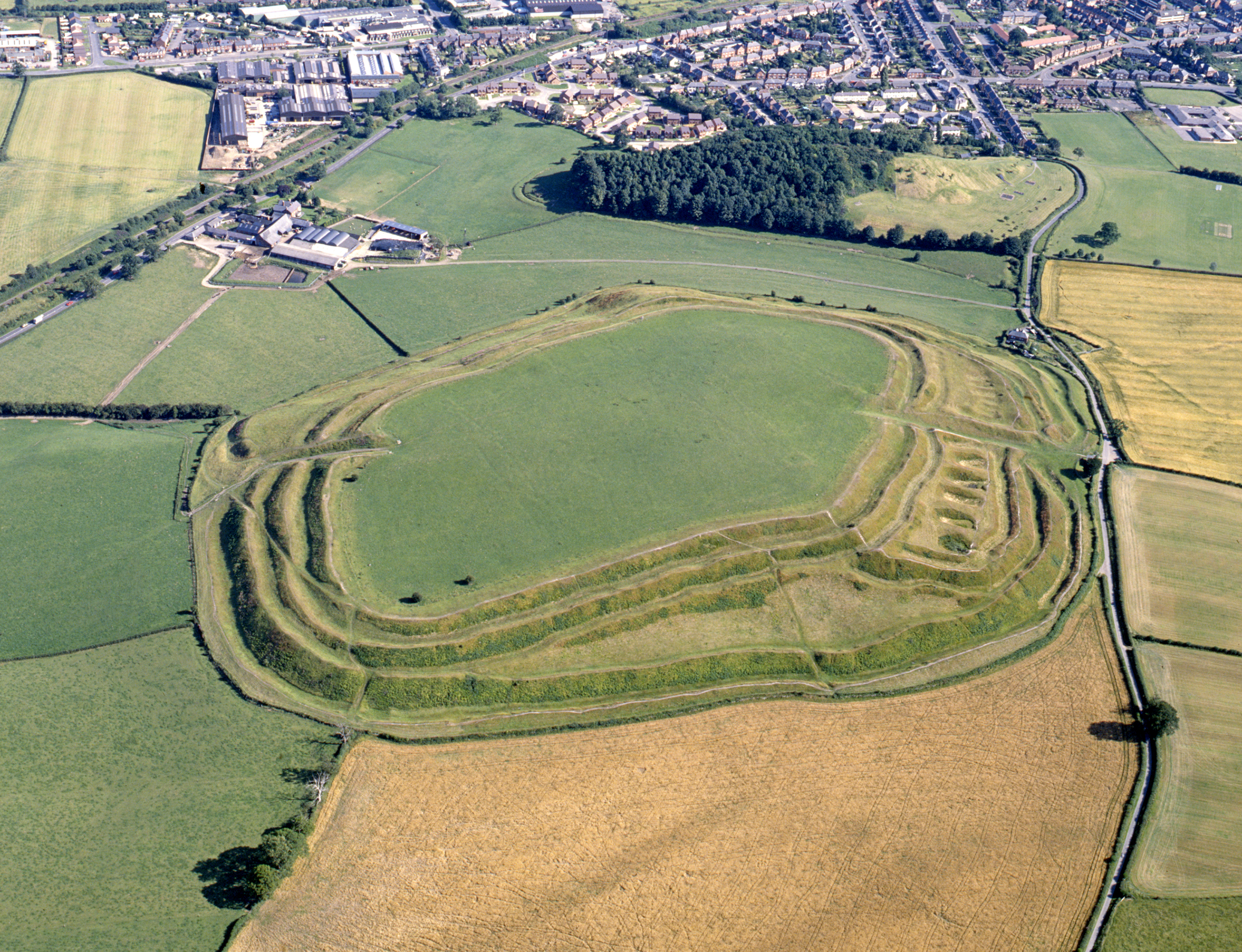
The hillforts on the Clwydians are in one sense a curiosity, so many together in such a restricted area. Moel Famau, at 555m above sea level the highest point on the range, is lower than some of the Berwyn heights and others in the Cambrian Mountains to the south-west, but it is the visually striking appearance of the Clwydian ridge towering over the Vale of Clwyd that impresses, and may have influenced the builders of the vast earthworks that straddle the ridge. There are six hillforts running from Moel Hiraddug in the north to Moel Fenlli in the south, and they range in size from Moel Arthur, whose defences enclose only 1.5 hectares, to Penycloddiau at 21 hectares (Figure 12a). Whether all were in contemporary use will be established only by extensive excavation. All are crest-sited apart from Moel y Gaer (Llanbedr), which sits on a spur jutting towards the Vale of Clwyd below. Without exception the defences are substantial. Some display internal house platforms: recent work at Penycloddiau has identified over 80 platforms that could have supported houses in the lee of the ramparts and into the interior (Jones 2004).
Overlooking individual stretches of the fertile Vale of Clwyd, these forts have been seen as providing refuges for valley dwellers when necessary, and supposedly developed as foci for social, political and perhaps religious purposes (Brown 2004, 68; Gale 1991, 89; Lynch et al. 2000, 161). Several of them seem to have directly controlled main passes over the Clwydians, indicative of strategic positioning. Whether they also acted as nodal points for the organisation and redistribution of the products of farming is another issue attracting varying views (Alcock 1965; Lynch et al. 2000, 162).
In focusing on the hillforts of the Clwydian Range it is easy to lose sight of the other forts across the region. Twenty-three have been identified, with at least two others not authenticated because they have been destroyed or damaged beyond recognition, and if one aspect stands out it is their heterogeneity. The distribution is significant and far from even. Inland from the coast by up to 6km are forts ranging from Bryn Euryn Camp above Colwyn Bay in the west and the fort of Dinorben — now quarried away — above Abergele, to Moel y Gaer (Rhosesmor) in the east where modern excavation has provided so much information on the dating and internal arrangements of a hillfort (for Bryn Euryn see Longley and Laing 1997; for Dinorben see Guilbert, this issue, also Gardner et al. 1964; Savory 1971; Guilbert 1980; for Moel y Gaer see Guilbert this issue, also 1975a; 1975b; 1976; 1981a). There are also those that populate the northern lip of the Dee valley from Y Gardden hillfort south of Wrexham to Caer Drewyn higher up the river above Corwen, while others lie by tributaries feeding into the Dee, such as Caer Caradog hillfort above Afon Ceirw and Craig yr Ychain hillfort above the Ceidiog. Though there are a few hillforts that do not conform to the pattern, the majority lie relatively close to river valleys or the coast, reflecting the presence of communities who understandably settled in these more hospitable landscapes rather than the high moors. Manley pertinently observed that the hillforts of the north-east are generally situated close to the upland/lowland divide rather than central to either, their locations seemingly effecting a compromise between the need for a defensive vantage point and access to lowland agricultural zones as well as upland pasture (Manley 1990, 33).
Forts with conventional sub-circular defence perimeters do occur, though the defences are not always moulded to the contours. In addition to Moel y Gaer (Llanbedr) and Moel Arthur on the Clwydians, there are well-defended enclosures of this form such as Moel y Gaer (Rhosesmor), Caer Caradog near Cerrigydrudion, Moel y Gaer on Llantysilio Mountain and several others. Most cover between 2 and 4 hectares internally. Some are larger. Bryn Y Gaer hillfort once covered over 5 hectares of a ridge and backed on to a steep-sided valley, but is now largely submerged beneath the 19th-century and later suburbs of Wrexham. Natural topography exerts a strong influence on the layout of other forts. Both the size and shape of Pen-y-Corddyn hillfort — nearly 10 hectares in extent for the main enclosure with a northern annexe half that size — is dictated by the craggy limestone outcrop that it occupies near Abergele (Davies 1929, 29), and Dinas Melin y Wig, which is also over 5 hectares internally, lies above the headwaters of the Clwyd to the south-west of Ruthin and occupies the whole of an interfluvial spur; again the influence of the topography being paramount. The demands of topography appear again with the small hillfort underlying the medieval castle of Castell Dinas Bran (Figure 12b), superbly sited on a prominent, isolated hill in the bend of the Dee, while at the opposite end of the topographical scale, Caer Ddunod surmounts a low hillock, probably of glacial origin, beside the River Alwen on the southern fringe of Mynydd Hiraethog, the hillock having its sides scarped to create a level protected interior.

Bryn Alyn fort, a little to the north of Wrexham, typifies the small group of promontory forts in north-east Wales. It is situated at the end of a ridge with the ground falling away steeply on three sides, one scarp enhanced by man-made banks, and the ridge itself cut off by three banks, over 3m high in places. The Roft promontory fort slightly further down the Alyn valley reputedly had massive ditches, 5-8m deep, cutting off an interfluvial spur, but quarrying has removed them; and Bedd y cawr hillfort on Cefn Meiriadog near St Asaph is also usually included in this class, with earthworks on two sides complementing the natural scarps to create an almost square enclosure that is just 0.6 of a hectare internally. Craig Adwy Wynt hillfort to the south of Ruthin and Castell Cawr above Abergele offer variations in that the man-made defences abut the edges of crags, thus dispensing with the need for additional rampart construction.
Compared with other areas of the Borderland, forts set on slopes are rare; Pen y Gaer hillfort to the north-east of Llangollen, set well down on a spur, being perhaps the only example. There are also no obvious multiple enclosure forts unless Pen-y-Corddyn with its annexe is included. An anomaly is the remote hillfort of Cerrig Gwynion above the Ceiriog valley, whose builders deliberately avoided a much stronger natural location several hundred metres away, presumably to gain a better command of the approaches from down river to the east.
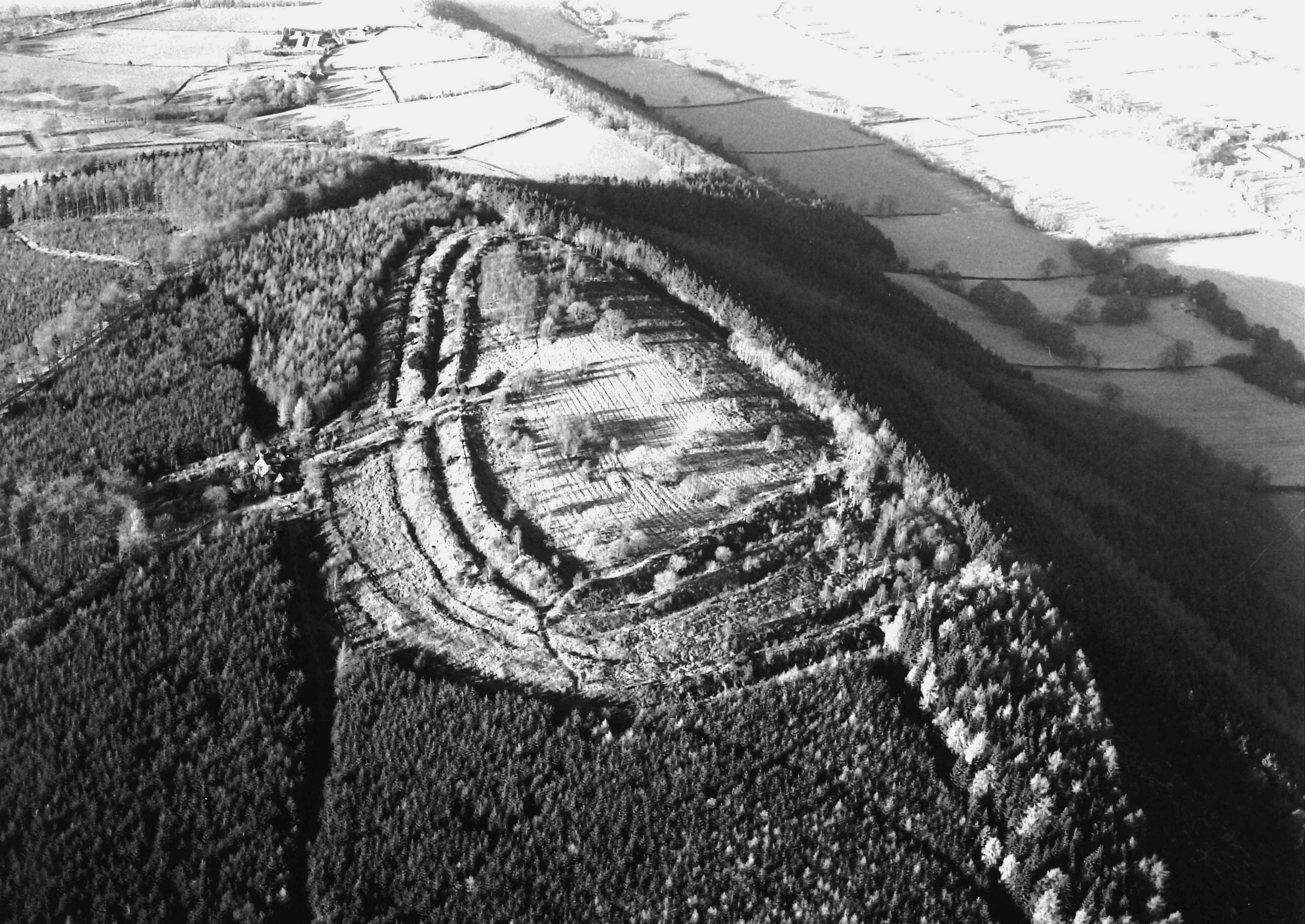
Despite the relatively small number of hillforts, the considerable variation in the form of these sites does little to suggest a consistent tradition of hillfort construction across the region. Nevertheless, the chronology of the few that have been excavated displays some consistency. Only Moel y Gaer (Rhosesmor) and Dinorben have seen much excavation, the latter as a result of the quarrying of the limestone hill. There were also early 20th-century excavations at Pen-y-Corddyn, which provided more information on the structure of the fort than of the fort's date (Gardner 1910), and intermittent work at Moel Hiraddug since 1960 (Brassil et al. 1982). Occupation at Moel y Gaer and Dinorben, another quarried hillfort (Figure 13), seems to have been from at least the 7th century through to the 4th or 3rd century BC, while Moel Hiraddug was first occupied in the 6th or 5th century BC and may have continued in use until the 3rd century. If they are typical of the north-east of Wales, it appears that the tradition of occupying hillforts was remarkably long-lived. It is worth noting too that three of the Clwydian hillforts — Moel Fenlli, Moel y Gaer (Llanbedr) and Moel Arthur — yielded small but distinctive collections of Roman pottery.
When we turn from the hillforts to the smaller enclosures, the picture is a little different. For one thing virtually no excavation has been conducted on any of the sites, and even where it has — at Y Gaer at Gresford or the T'yn-y-wern Farm cropmark near Ruthin — the results have been disappointing. Additions to the corpus of known sites have been slow. When John Manley surveyed such sites in the early 1980s he was able to identify 42 examples (Manley 1990). Disappointingly, that figure has advanced by only 16 since then, and for such a large area, overall numbers are low. There are perhaps no more than 40 authentic earthworks that currently are recognised and just over 30 cropmarks. Some uplands, such as the Denbigh Moors, the Berwyn Mountains and even parts of the Clwydian Range, appear completely devoid of enclosures whatever their nature, seemingly confirming the traditional belief that the uplands were largely unpopulated in the later first millennium BC and into the Roman era. This, though, is too simplistic: evidence is accumulating from across upland Britain of a return to the uplands, but perhaps on a seasonal, transhumant basis (Haselgrove and Pope 2007, 7) and this is what has been evoked for the small, 2nd-century BC hut found during the Brenig excavations in 1973 in a small side valley feeding into the Brenig valley at a height of 410m above sea level (Lynch 1993, 160). The evidence currently available from the distribution pattern is that it is the enclosures reflecting permanent settlement that are missing from the uplands.
The dichotomy between the enclosures surviving as earthworks and those appearing solely as cropmarks that emerged in the assessment of southern Powys can be paralleled in north-east Wales. The small earthwork enclosures interpreted as defended farmsteads share some distributional characteristics with the larger hillforts. One focus is on the slopes of the upper Dee valley and its tributaries, with a scatter along the western margins of the Vale of Clwyd and a noteworthy concentration in the foothills to the east of the Clwydians where these dip towards the coast. Cropmarks are infrequent in these areas, but not surprisingly there are some on the floor of the Vale of Clwyd, and further to the east where the Welsh lowlands merge with the Cheshire Plain. Most intriguing here is the situation in the flat terrain of Wrexham Maelor — where north-eastern Wales projects into England east of the Dee — where Triassic rocks overlain by fertile loamy soils were extensively cultivated, as evidenced by more medieval ridge and furrow than anywhere else in Wales. Conditions seem not to favour the appearance of cropmarks, yet in a few locations, such as Blackhurst near Bettisfield, the potential of the area is obvious (see below). The distributions of earthworks and cropmarks are not then mutually exclusive, but in broad terms to the east of the Clwydians and the Berwyn Mountains, small earthwork enclosures give way to cropmark sites.
Most of the earthwork enclosures are relatively small and 23 (75%) have internal areas of less than 0.5 hectares while the largest is just over 0.8 of a hectare. A significant majority are broadly oval or have a curvilinear form, best classed as D-shaped, but there are two polygonal and three more rectilinear examples. Most are protected by a single bank and ditch, though occasionally, as with Pwll y Clai near Cyffylliog, a second defensive line has been constructed. Topographical siting varies from the eight on hill-tops, though these are rarely the natural strong locations adopted for some hillforts, a similar number on flat ridges or plateaux, and apart from one sitting on a valley floor, the rest are on hill or valley slopes. Yet as a group they reveal a fair degree of coherence. The cropmarks show greater variation in form and size, despite the rather fewer examples. Within the small group of unambiguous sites, numbering little more than 20 and ranging in size from around 0.1 to 0.9 hectares, the full range of shapes seen elsewhere are exhibited, from rectangular through D-shaped to circular and ovoid. Among them are five double-ditched enclosures whose locations range from plateau top to valley floor.
There are exceptional sites in both categories, some standing out not because they are spectacular in form, but because of their associations. Caer Drewyn falls into this category (Figure 14), as do the Bryn Teg and Tyddyn Tudor enclosures, both with associated field banks, in the hills between the Alwen and the Ceirw, south of Mynydd Hiraethog (Figure 15). Another is the Blackhurst cropmark complex in Wrexham Maelor where a simple rectilinear enclosure, one of two no more than 100m apart, appears to be associated with an adjacent field system defined by slight, irregular ditches.
It is Wrexham Maelor that provides a link with the situation encountered in Cheshire. The only hillforts and other defended enclosures appearing as earthworks in Cheshire are nine or so examples strung out along the central sandstone ridge (Longley 1987; Nevell 1998). These include a few smaller enclosures such as Maiden Castle, Bickerton, and Bradley above the River Weaver, both enclosing around 0.7 hectares, as well as the better known and larger hill forts like Eddisbury and Beeston Castle at 2.8 and 4 hectares respectively. Away from the sandstone ridge, there is only a single enclosure, Burton Point, at the base of the Wirral Peninsula. Earthworks are a rarity in Cheshire, and regardless of whether this was as a function of topography, later ploughing, or cultural differences, the difference from the adjacent Welsh hills is unequivocal. The cropmark evidence, on the other hand, extremely limited though it is, parallels what is emerging in the lower lands of north-east Wales. Very few sites have yet come to light between the Dee valley and the Cheshire ridge, but those that have been identified fit comfortably in the range of cropmark types already considered.
What is pertinent to this general discussion of north-east Wales is that Philpott has argued on the evidence drawn from across the Merseyside region that the double-ditched curvilinear enclosures are likely to be of late prehistoric date and were indicators of a strong initial emphasis on pastoralism, the area between the ditch circuits being used to corral cattle (Cowell and Phillpott 2000, 185). Over time a movement toward arable farming led to their abandonment in favour of rectilinear enclosures. He has suggested too that there may have been a breakdown in the tribal or clan system where communal herds were held and sorted at specific centres, and that as individual farms were established the double-ditched enclosures were abandoned.
The Cheshire cropmarks, as elsewhere in the north-west of England, are considered to signal a significant population increase in the Roman period as a result of an increasingly stable society strongly influenced by the imposition of military centres across the region (Cowell and Phillpott 2000, 181). The more prevalent rectilinear enclosures are likely to be specifically of Roman date, in line with other parts of the north-west of England, though distinct from the pattern further south in Shropshire (Cowell and Phillpott 2000, 184).
Internet Archaeology is an open access journal based in the Department of Archaeology, University of York. Except where otherwise noted, content from this work may be used under the terms of the Creative Commons Attribution 3.0 (CC BY) Unported licence, which permits unrestricted use, distribution, and reproduction in any medium, provided that attribution to the author(s), the title of the work, the Internet Archaeology journal and the relevant URL/DOI are given.
Terms and Conditions | Legal Statements | Privacy Policy | Cookies Policy | Citing Internet Archaeology
Internet Archaeology content is preserved for the long term with the Archaeology Data Service. Help sustain and support open access publication by donating to our Open Access Archaeology Fund.