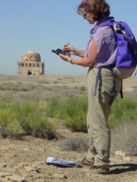
A ground-truthing GPS field survey was undertaken using a Hewlett-Packard handheld IPAQ, fitted with a Navmansleeve GPS 3400, and running Pocket PC 2002 and ESRI ArcPAD (version 6.0.2) (Fig. 28). This enabled digital access to the IKONOS satellite image and APs in the field, and positions to be located on these to within c. 3m. As such, it was sufficiently accurate to enable the user to distinguish between one ridge, mound or area of vegetation on the image, and another.
Figure 28: Checking the aerial imagery on the ground using a handheld PDA with GPS. The PDA was running ESRI ArcPad 6.0.2, enabling the GIS, including satellite images and aerial photographs, to be viewed in the field, with a Navman GPS sleeve providing the location of the surveyor to within 2-3m on the image. Sometimes it was easier, due to the strong light, to confirm details of the image on a printout, but the electronic system was invaluable in a landscape of numerous similar ridges and depressions.
There were a number of difficulties in interpreting information on the satellite image or APs – for example, whether dark areas on the images represented vegetation, or spreads of dark soil/debris – but these could be easily resolved on the ground. Ground truthing was clearly vital, but this would have been practically impossible without the handheld GPS and the ability that it afforded to relate the users' position in the field to the satellite image or AP.
There were some problems with the small screen size, and being able to see the images sufficiently well in strong sunlight, but these were overcome by taking into the field printouts of the images at high resolution, allowing the users to locate themselves with the GPS and digital image, but annotate the paper copy, which was then digitised on return to base. Overall, this system worked extremely well.
This allowed a number of identification and interpretation issues to be resolved, and these are recorded in the built/unbuilt space database.