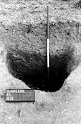
Figure 25: Pit 1036 (part of pit group 1).
Commentary on the Site Description (2008)
Twenty-six features were classified as pits, which were defined as being over 1.00m in width and of circular, oval or sub-rectangular plan. In particular, however, pits could be generally distinguished as a group by their fill, which (apart from PG4) was usually different from other features, even those in the immediate vicinity. They were of two kinds, broadly characterised as either vertical-sided, or sloping-sided/bowl-shaped. Pits of like kind tended to occur in groups, or at least in well-defined discrete areas. Pit groups 1-5 were dated to Period 3, either because they contained Iron Age artefactual evidence, or because their location was associated with other directly dated features. The dating of any isolated pits was generally more difficult.
This group (0001, 0002, 0003/1036 (Fig. 25), 1035, 1039 and 1043) lay just inside the entrance to the enclosure behind the bank of the inner ditch. The pits themselves were not all contemporaneous, as pit 1035 was clearly cut by pit 1043, and pit 1039 may post-date 1035, if fill 1035.5 was spoil from 1039. After these pits had all been infilled, a system of interconnected shallow scoops was dug into their top fills (except for 0003/1036; Fig. 25). This 'scoop-system' appeared to be contemporaneous, with the probable exception of 1042 which was added afterwards. 0002 could belong in its entirety to the 'scoop-system', in which case it would have post-dated 0001. A thick clay capping (0001.1), which produced Roman material, overlay pits 0001 and 0002 and the 'scoop-system'.
Figure 25: Pit 1036 (part of pit group 1).
Such pits were perhaps used originally for storage (possibly of grain) – being vertical-sided, they would have been well-suited to this purpose. Pit 0003/1036 appeared particularly suitable for this function, with its comparatively high depth-to-diameter ratio, difficult to achieve in this sandy gravel. All seemed to have been used latterly as rubbish pits. At an intermediate stage 1035 appeared to have been converted into a water tank by the insertion of a clay lining (1035.4; cf. Beckford; Britnell 1974).
Burnt and heat-cracked stones and pebbles in the fills of most of these pits might imply that cooking, using potboilers, was the activity producing much of this rubbish. The fill of pit 0003/1036 (Fig. 25) was far more complex, as there were interspersed layers of clay, sand, and ash, all tipped in regularly, as if some industrial or domestic process of a small but repetitive nature had resulted in the fill. A great deal of Droitwich briquetage was also found in the 'scoop system' (and hardly any in the pits below), so salt possibly had a part to play in the activities at this level, perhaps reinforcing a cooking interpretation.
This comprised four pits (0128, 0136, 0139 and 0415; Fig. 26), and a small scoop (0409; Fig. 26). 0136 and 0139.3 were broadly contemporary, each containing a joining sherd from the same pot. The exact context of the sherd from 0136 has been lost, but it was either from 0136.3 or 0136.7.
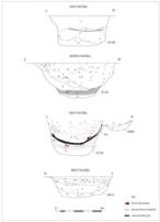
Figure 26: Pits in pit group 2: sections.
A primary function is difficult to assign to this group of pits. They are presumed to have been dug for storage despite having non-vertical sides, which in any case seemed to be the result of re-cutting (as in 0136 and 0128) or to be very nearly vertical (as in the other pits in the group). 0136 was just about big enough to work in and the burnt clay and ashy rubbish layers near the bottom (0136.5 and 0136.6/7) might be the remains of hearths. The top surface of 0136.5 was disturbed, as if by trampling. Before it was re-cut, 0136 was smaller, and perhaps much smaller than it was after re-cutting. However, burnt clay and ashy material (0136.5) was deposited before the pit was re-cut, so this was probably rubbish from elsewhere. An extensive deposit of ash lay directly on unburnt clay in pit 0139 (0139.4 and 0139.9) indicating that the pit had not been fired, but instead used to dump ash, or possibly to store charcoal. The unburnt clay appeared to be the remains of a lining inserted in 0139 after it was nearly half silted (cf. 1035 in PG1).
Unlike pit group 1, burnt and heat-cracked pebbles were quite rare, perhaps indicating a difference in activities near this pit group. The group 2 pits were, to judge from silting in their bases, left open for a short while before being filled. This indicates a short hiatus between their last being emptied and their final filling, unlike those in pit group 1, apart from pit 0001. There was no evidence upon which to assign a function to the scoop 0409.
This group comprised only pits 0080 and 0098 (Figs. 27-8), and, as an outlier, 0093, and an associated scoop, 0077. Pit 0080 cut and, therefore, post-dated pit 0098. It contained burnt debris, comprising the usual clay and ash, and 0080 may have had a hearth in it (0080.1a), although this ash deposit was perhaps better interpreted as swept-in debris. This pit group is remarkable for the fact that pits 0080 and 0098 between them contained c. 55% of all Iron Age pottery on site, and that pit 0098 alone produced 10 out of 28 iron objects (Fig. 43, and Fig. 44, no. 1) from the site. The total is raised to 13, if finds from nearby contexts 0077 and 0081 are included.
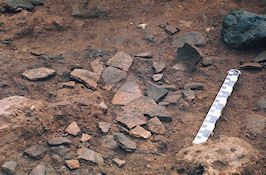
Figure 27: Pit 0098 (pit group 3) showing concentration of pot sherds (Fig. 38, nos. 12-20) in fill.
The original function of the pits is, of course, difficult to assess but it seems likely that pit 0098 was related to the function of building 1 (BG1), within which it sits. An exactly similar situation is apparent at Gun Hill, Essex (Drury and Rodwell 1973). The pit may have been part of the equipment of a working area, represented by building 1 (see above). One interpretation could be that pit 0098 contained material deriving from demolition debris from building 1, with pit 0080 dug later so it contained a different range of material.
Both of these pits were sealed by a single thin layer of dark brown soil containing a few sherds of Roman pottery of 2nd-3rd century date (including a sherd of samian ware in either case, that from the pit 80 sealing being 2nd century in date (archive note; both sherds now missing), and this soil was probably a remnant of post-settlement ploughsoil, containing sherds dumped in it as part of field manuring using midden material incorporating domestic waste (see Period 4). This particular soil deposit is not paralleled elsewhere on the site, and it is suggested that this patch escaped erosion by later (i.e. post-Roman) ploughing only because it had collected in a hollow over the pits, caused by the compaction and subsidence of their fills.
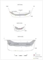
Figure 28: Pits in pit group 3: sections.
This group of three small shallow pits (0422, 0423 and 0427) is unusual because the fills are unlike those of other pits, being a uniformly sterile, sandy loam. The pits are not all contemporary; 0427 is probably later than 0423. Pit 0422 is deeper but more irregular in plan and profile. There is insufficient evidence to assign a function to this group, and the absence of finds also raised the prospect that they might be of pre-Iron Age date.
Four pits (0116, 0150, 0181, and 0467) occurred in a line that seems to respect an open space, the alignment being continued by features 0114, 0117, 0134, and 0105. The pits were of varying shapes and fills, and have no obvious relationship to each other apart from their common alignment. Pit 0150 (Fig. 29) looked like a typical pit group 2 type ?storage pit, being very like pit 0139, including its relationship to a small scoop (0419) to one side.
The other pits were of different kinds. Pit 0181 may be a large double post-pit with two oblong post-impressions in its base, pit 0116 a shallow, bowl-shaped pit, while pit 0467 (Fig. 29) was unusual because of its size. At about 2.5m in diameter and 1m deep it was the largest pit anywhere on the site, but was proportionally quite shallow and bowl-shaped. It produced no evidence of domestic or industrial activity. Halfway down the section there was a possible turf line which would indicate a period of disuse, but there were no finds to corroborate a long period of infilling involving periodic stasis. In the context of the site it was notable that six flints were found in this pit.
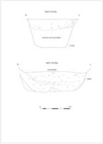
Figure 29: Pits in pit group 5: sections.
Pit 0035 (G4; Fig. 11) was close to 0047 and similar in shape, size and fill to pit 0001. The top fill contained some ash and 'daub' (the latter not retained; possibly briquetage), but was disturbed, also producing some modern pottery (no longer available).
Pit 0047 (G4; Fig. 11) was oval in plan and conical in section. Its fill consisted mainly of variously coloured clays, which may suggest that clays from various sources had been stored. Vertical or steeply sloping boundaries between the layers suggest further that clay was periodically removed and that deficiencies were made good at intervals. Clay storage pits have been recognised at hillforts such as Danebury (Cunliffe 1976), Winklebury (Smith 1977) and Hod Hill (Richmond 1968).
The upper silting of the original pit 0246 (H4; Figs. 11 and 30) produced a brooch of La Tène II type (0246.3; Fig. 44, no. 2). The pit was later recut, and the resulting smaller pit was filled with the kind of burnt debris typical of many pits on the site, a blackened sand layer (0246.2).
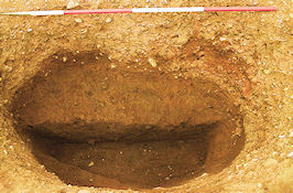
Figure 30: Pit 0246.
Pit 0256 (H4; Fig. 11) was notable for exhibiting the standard 'Blackstone fill' common to features other than pits (see 3.1 and 3.3.3.8).
Feature 1550 (G7; Fig. 13) was circular in plan but too saucer-shaped in section to be normally counted as a pit, though its fill was entirely uniform with the other pits. A central, darker zone in the fill (1550.1) contained all the finds from this feature plus some burnt clay. The finds included some flints, and a large amount (for this site) of pottery and briquetage. In fact, after pits 0098 and 0080, this feature contained the largest assemblage of pottery on site. It may be significant that no other feature in the immediate area had similar contents.
Pit 1631 (K7; Fig. 14) was identified as a tree hollow.
The pits formed a unified and easily recognisable class of feature at this site, and the more closely similar examples tended to occur within the pit groups. Pits with similar fills tended to occur together, even when not strictly contemporary. This presumably suggests some continuity of function in and around these pits and leads to speculation about deliberate activity zoning. At the least it seems that there were clearly defined areas where activities involving pits occurred. The general distribution of pits away from the main concentrations of features in the south-east corner of the enclosure reinforced this suggestion, although it assumes a pattern not distorted by only partial excavation.
It is difficult to make convincing suggestions as to the function of the pits, because appropriate evidence is usually weak or lacking. The probabilities of specialised uses such as clay and water storage have been noted, and it is likely on general typological grounds that storage of one kind or another was the main reason for the original digging of pits. Their final fills, so often of a similar kind, including much evidence of burning, indicate that in their later stages pits were often associated with some kind of domestic or industrial processes. In the absence of any definite identification of industrial activity this is best taken as domestic, especially cooking (potboilers, briquetage and pottery). The pits that exhibit clean, nearly sterile soil fills are usually seen to be rule-proving exceptions, since in general they fall outside, or near the limits of, the size and shape ranges of the other pits. Attention has already been drawn to the probable early date for one of the atypical examples, pit 1027 (see Period 2).
There was some evidence that pits were apparently required singly and sporadically by the Blackstone inhabitants. Existing pits were often allowed to fill almost completely before being cleaned out or replaced. This refurbishing and replacement in the same locality, would imply organisational restrictions (social, proprietorial, or functional) on their positioning.
© Internet Archaeology/Author(s)
URL: http://intarch.ac.uk/journal/issue28/3/3.2.3.10.html
Last updated: Wed July 21 2010