Figure 22: Palisade II: trench and postholes (1613-1616) to rear of internal rampart.
Commentary on the Site Description (2008)
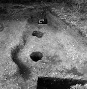
Figure 22: Palisade II: trench and postholes (1613-1616) to rear of internal rampart.
This appears most clearly in cutting 1549, where three post-pits (1549.6-8; not illustrated) were excavated in the top of the inner ditch (Fig. 14). These post-pits were c. 0.25m deep and 0.40m in diameter. The posts in this palisade were, unlike the close-set timbers of Palisade I, placed up to 2.5m apart and this could well have been missed in the 1972 and 1973 excavation seasons.
In the south-west corner of the site (grid square H8) a short length of linear feature (1613; 0.80m wide and at least 2.0m long; Figs. 14 and 22) was noted 5m behind the inner ditch, associated with two postholes with post ghosts (1614 and 1615; 0.30m diameter and depth of 0.40m), and two smaller postholes (1616 and 1675; 0.15m diameter, and c. 0.20m deep). This line of posts ran parallel to the inner ditch; and, like it, runs towards the brow of the steep slope to the west. Considerable animal burrow disturbance (1566) was also noted in this vicinity.
The slight depth of the post-pits for Palisade II indicates that its posts would have required bracing if they were to remain upright. No evidence of timber bracing was forthcoming and so it is assumed that an earthen bank would be piled around the base of this palisade (see below, where it is suggested that this soil came from digging the outer ditch). Reinforcement of the rear of the palisade (producing a timber-faced bank) would not be sufficient unless the uprights had been laced into the bank. Such lacing may seem an incongruously elaborate arrangement for a rural settlement enclosure, and so the piling of soil on both sides of the palisade is preferred.
One suggestion for the function of this structure is that it guarded the awkward transition from enclosure bank to steep natural slope. It perhaps continued along the brow of the slope, to delimit the enclosure on the west and north sides. This hypothesis could not, unfortunately, be tested at the time of excavation. Today a strip of land along the extreme western and northern limits of the enclosure may still survive intact after quarrying and so the hypothesis may still be capable of being tested.
© Internet Archaeology/Author(s)
URL: http://intarch.ac.uk/journal/issue28/3/3.2.3.7.html
Last updated: Wed July 21 2010