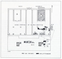
Figure 37: Location of the stratigraphic soundings (Pisani Sartorio et al. 1989, 14, fig. 1)
Figure 37: Location of the stratigraphic soundings (Pisani Sartorio et al. 1989, 14, fig. 1)
The intermittent character of the research conducted at S. Omobono and the sheer complexity of the site have inevitably resulted in a convoluted and fragmented publication and archival record. The published reports and the excavation notes of the major stages of archaeological work conducted in the area employ different conventions to describe excavation units and stratigraphic sequences, making it difficult to relate corresponding layers from different areas of the site (cf. the published trench map, Figure 37). This section reorganises the available published and archival evidence illustrating the development of the site from the earliest phases of human activity to the substantial reorganisation of the site during the Imperial period. For the sake of clarity, the material is presented by trench and can be accessed by clicking on hotspots on the site plan (see Figure 34) or on the list of trenches below (n.b. a site plan without trenches marked is available for download at Figure 38). To make the cross-referencing with the published reports easier, correspondences are made with a chronological list of titles.
The syntheses presented below are based on careful correlation of the published evidence with the archive. This detailed work is revealing inconsistencies and even contradictions in the various accounts. Years will be necessary before the re-analysis is complete. The work on the archival evidence is particularly advanced for settori I-X and for the Tempio Ovest trench. For the other trenches, the analysis is based primarily on the publications.
© Internet Archaeology/Author(s)
University of York legal statements | Terms and Conditions
| File last updated: Mon Mar 12 2012