There are, regrettably, no early plans at a reasonably large scale of either the wider St Jude's development itself or, indeed, of individual buildings within it. We can dismiss from the outset a range of cartographic material that, while of some use for the street layout and street names, do not show many individual buildings, but simply, for the most part, undifferentiated blocks of developed land. The Bristol maps of John Rocque (c. 1740) and Benjamin Donne (1773) both fall into this category. As we have already noted, the 'second edition' of Millerd's map is usually dated to around 1710 and, unlike the 1673 edition, it shows the Frome Bridge, which lay at the north-western end of Wade Street, but it shows no element whatsoever of Nathaniel Wade's St Jude's development itself, under way before 1707. On balance, the likelihood is that Millerd simply ignored the new streets for his later edition, perhaps because it was peripheral to the city, and also, unlike the splendid and prestigious new Queen Square, it was (notionally at least), in the final analysis, a humble development of workers' and artisans' dwellings.
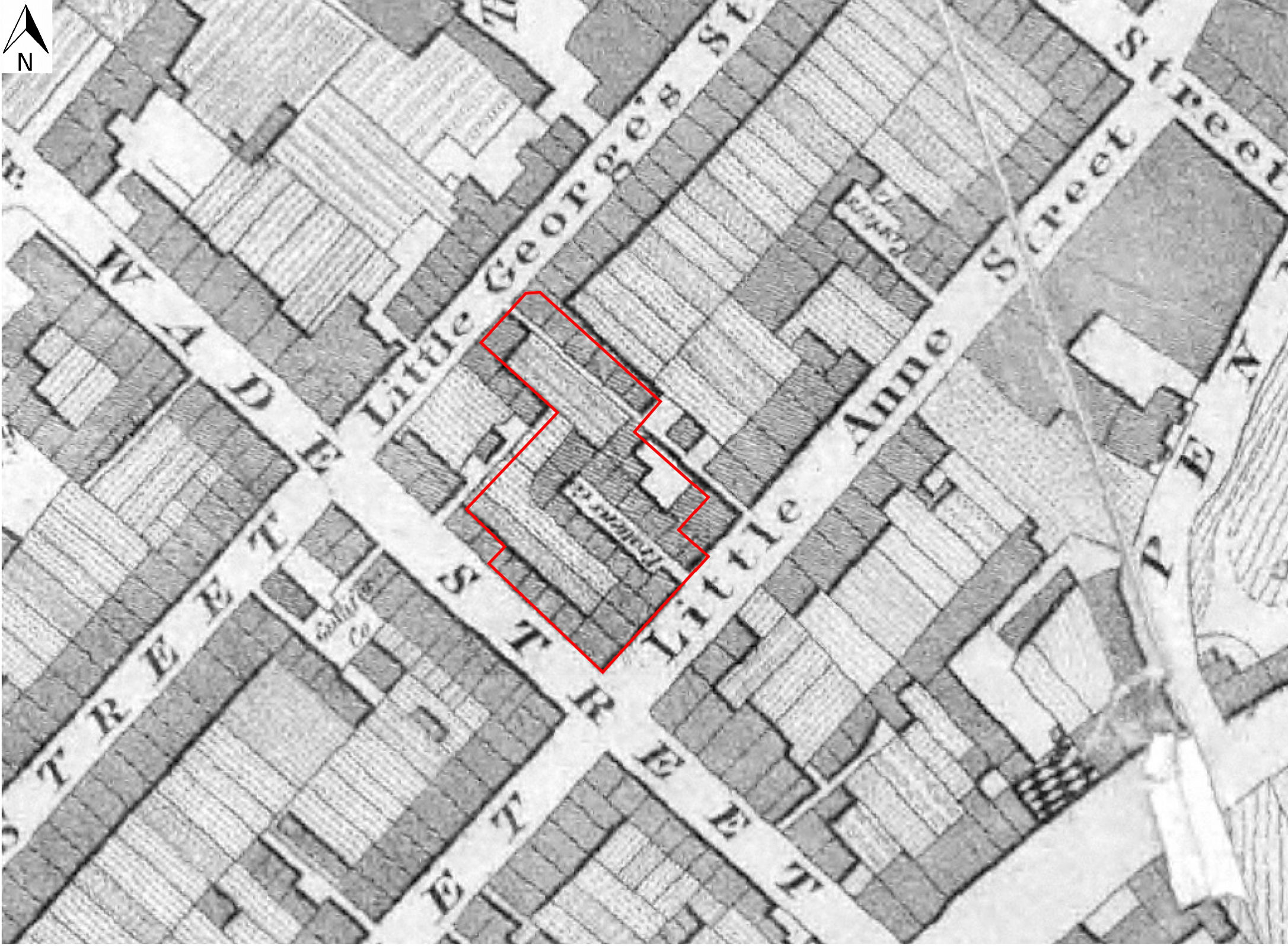
The earliest plan of the site that could in any sense be said to show any meaningful detail is Plumley and Ashmead's map of 1828, which purports to show the individual properties fronting Wade Street and Little Anne Street, and also shows two new blocks of buildings running parallel with Wade Street, away from the street frontage (Figure 4) (Mason 2013, 3). One is a row of buildings running north-west from the Swan With Two Necks public house, fronting onto a narrow alleyway later known as Swan Court, and running between Little Anne Street and Little George Street. The second is a shorter cul-de-sac, formed by two rows of five small dwellings, running north-west from the northern side of Little Anne Street, later known as Pratten's Court (Mason 2013). Historic map evidence shows that at some point between 1918 and 1935, the two most northerly houses on either side of the court, nos 5 and 6, were removed, necessitating a renumbering of the remaining houses on its north-eastern side.
What we cannot know from this, or any of the other maps alone, is whether or not Pratten's court was an element of the original, early 18th century layout, although it seems unlikely. The ceramic assemblage from contexts sealed beneath hard surfaces within what we know to have been Pratten's Court, is, unfortunately, not very helpful in this respect in terms of precision (Appendix 2). What is striking in particular about this map is the surprisingly high level of open space behind the street frontages even at this relatively late date (we should bear in mind that the first Ashmead survey dates to a period some 120 years after the earliest elements of the development began to be laid out). It seems clear that Ashmead intends us to understand that these open spaces were, at this date, gardens rather than yards. Note also the small alleyway that runs north-east/south-west off the north-eastern side of the Wade Street frontage, within the site boundary, and which from later maps was encroached upon by buildings, although still with (probably covered) access from the street. The surface of this little alley may well have been identified in the post-excavation watching brief stage of this project (Figure 3; and see later).
It is interesting that this earliest of the Ashmead surveys shows the plot boundaries behind the Wade Street frontage as running north-west/south-east, and so by inference, they pertain not to the properties actually fronting onto Wade Street, but to those at the south-western end of the Little Anne Street frontage. This seems intuitively incorrect, since we would reasonably expect plot boundaries to run in the same direction as the sides of the buildings behind which they lie. The establishment of plot lengths of 80ft (24.4m) in the earliest phases of the development, would, as we have already suggested, see the tenement boundaries of those premises fronting on to Wade Street running all the way back to the site's main spine wall (Context 1043).

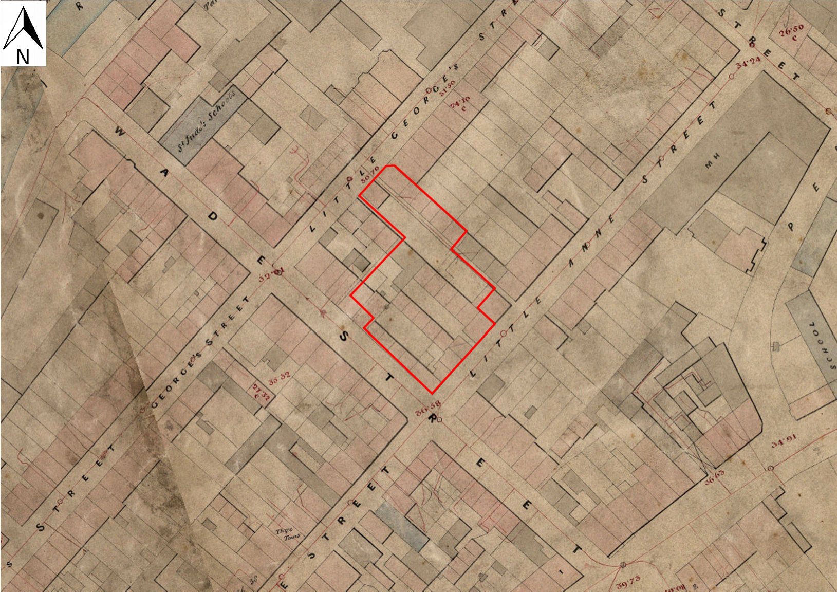
The tithe map for St Philip and Jacob out-parish dates to 1847 (BRO EP/A/32/10), and historically, the excavation site fell within it until the construction of St Jude's church in 1849 (Figure 5). The map shows no apportionment numbers for the Wade Street estate, and pretty much the same lay-out of buildings as at the time of the early Ashmead plan (Smith and Erskine 2000). 13 The open spaces remain as before, although unlike Ashmead c.20 years earlier, the tithe map does not make it absolutely clear whether these remained as gardens to this date, or had been laid down to hard surfaces by then.

There were two further editions of Ashmead's Bristol survey, the first dated to 1855 (Figure 6). There had by this time been few changes in the extent of building on the site, although an open area shown fronting onto the south-eastern side of Little George Street, at its south-western end, has become rather more encroached upon by the construction of two small buildings that may just be 'new' outhouses or sheds relating to existing houses fronting onto Wade Street and Little George Street, respectively. These buildings are shaded light grey, indicating a non-domestic use, as opposed to the pink shading for a house or other dwelling. At this date also, the main spine wall running south-east/north-west, and which appeared to be the earliest built element on the excavation site (Context 1043), has buildings set off from its south-western side along its entire length, but on its north-eastern side there is but one, the remainder being open garden or yard surfaces, except for a building at its north-western end, fronting onto Little George Street.
The Ashmead map was revised again some 20 or so years later, in 1874, and there is very little change discernible in the site layout since the earlier date (Figure 7). One of the few noticeable changes is the disappearance of a large outhouse or shed from the north-eastern (rear) side of the row of smaller houses that front onto Wade Street.
Because Bristol was a major city, and by the late 19th century had been so for a very long time, we are fortunate that when the First Edition of the OS map appears, in 1881-2, it is immediately available as a town plan, at the very large scale of 1:500 (Figure 8). This of course gives an unprecedented level of detail, although the OS maps should not be regarded as invariably completely accurate, especially away from the street frontages. 14 Much of the internal, open space that had characterised the site over half a century earlier, in 1828, had been heavily encroached upon. Although it is impossible to be certain, these spaces had probably ceased to be gardens by the time of Ashmead's second edition map, and had by that time probably long been appropriated for hard-surface yards and standing. Over some of the site that could be seen clearly in section, there had been the intermittent development of a dark, organic, cultivation-type deposit underneath the hard surfaces, 15 the best explanation for which is probably that these were garden soils, having been developed either out of original, unworked pasture grounds, or imported and lain on top of a dumping/levelling layer that marks the beginning of systematic development on this site.
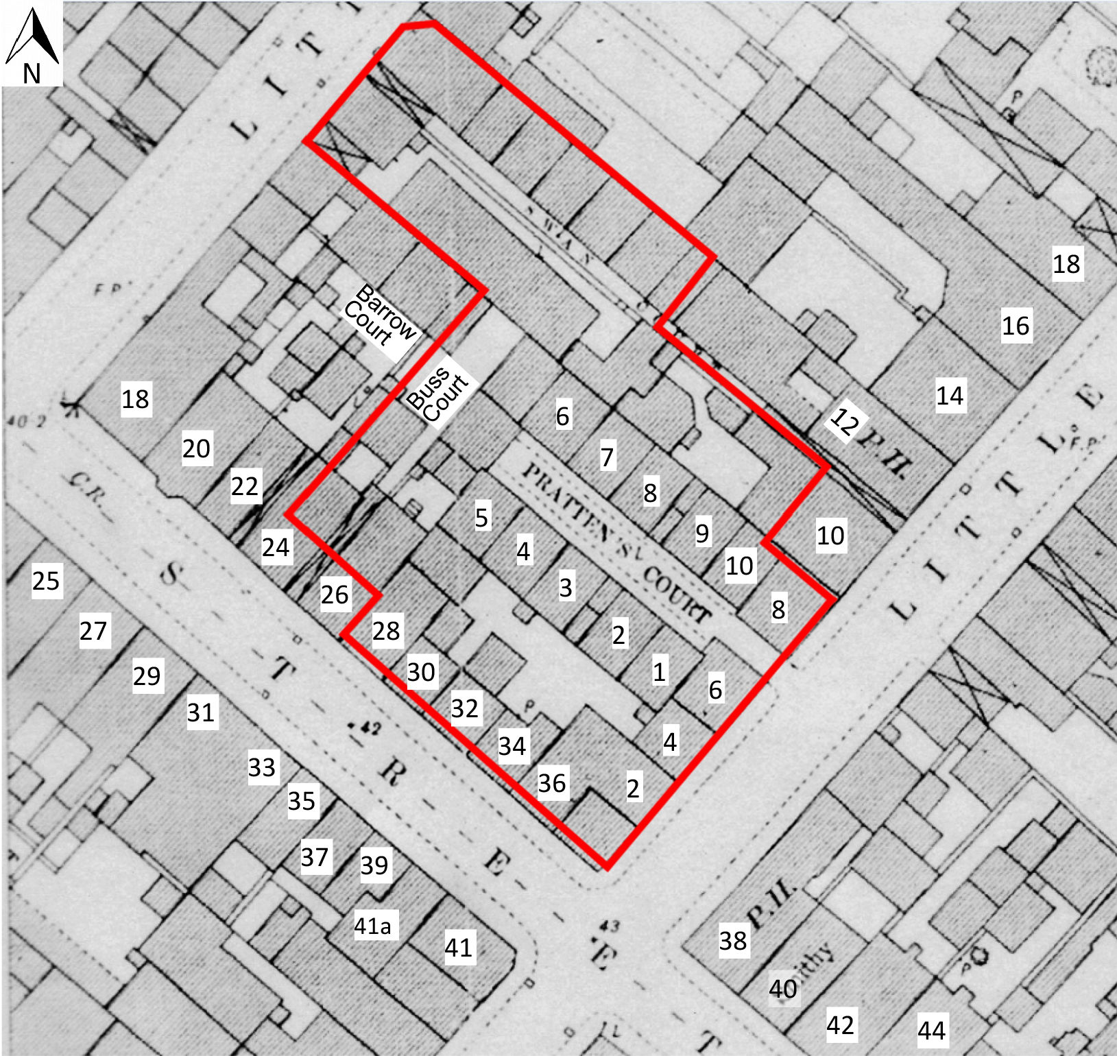
A further two larger buildings had by this time been constructed north-west of Pratten's Court, and several of the Pratten's Court dwellings, and the two most recently constructed, have adjoining wash-houses or out-houses. The L-shaped arm of a further building north-west of Pratten's Court appears to have been demolished by this date, and further infilling has occurred between Pratten's Court and Swan Court. The 1881-2 map shows a second public house, on the opposite side of Little Anne Street from the study area, at the corner of Little Anne Street and Wade Street, recorded as 'The Berkeley Arms', and functioning as a pub until at least 1910 (Smith and Erskine 2000, 5-6). Adjacent to the excavation site, Bristol trade directories list a further two public houses fronting Wade Street, 'The Ship', on the corner of Wade Street and Little George Street, and 'The Sportsman's Arms', still surviving as the Al Baseera Islamic centre, immediately to the south-east. Both are recorded in 1880 (Smith and Erskine 2000, 6), but oddly, neither is identified as a pub on the OS 1:500 plan. Further traders occupying the site's Wade Street frontage at this date include a tin-plate worker, a tobacco-pipe maker and a boot-maker (Smith and Erskine 2000); see Appendices).
Comparison of the 1881-2 OS map with a local authority Compulsory Purchase plan of 1935, together with its accompanying property descriptions (BRO Modern Records 8160A; Figure 9) shows that the sites of no fewer than four properties, 20 and 22 (together forming the Sportsman's Arms pub), 24, and 26, have been set back from the Wade Street frontage by some 4m. One large building has been constructed on the formerly open yard area on the south-west side of Swan Court, while immediately north of Pratten's Court, the plan shows two rows of probable wash-houses or latrines abutting the northern property boundary.
The First Edition OS plan also shows 24 Wade Street (not numbered), flanked by covered alleyways, leading to a rear yard and small outbuilding. The documents associated with the 1935 plan list 26 Wade Street as a messuage or dwelling house, and describe two further messuages or dwelling houses [which] were formerly known as 1 and 2, Buss Court Wade Street. These are the two larger buildings first noted on the First Edition OS map (Figure 8), just north-west of Pratten's Court. The above buildings are not present on the Compulsory Purchase map of 1935, which shows a large shaded area obscuring the area of the former nos 24 and 26, and the land to the rear. The remaining dwellings fronting Wade Street have also been re-numbered by this date (Smith and Erskine 2000, Figure 6). The Compulsory Purchase order of 1935 paved the way for the demolition of housing which had, by that time, come to be considered as inadequate. A preliminary examination of 19th-century census material indicates that, from at least 1871, a small group of houses collectively known as Barrow Court, occupied a site to the rear of 20 and 22 Wade St, roughly where the Al Baseera Bristol Islamic Centre is now, abutting the excavation site on its north-west side. Access to this court was made presumably via the alley shown between nos 22 and 24. Neither Buss Court nor Barrow Court appear to be identified by name on any map of this area that we have so far been able to examine, but census records appear to show clearly that Buss Court was in existence by 1891, and perhaps earlier; as we can infer from records that describe 'cottages to the rear of no. 26'.
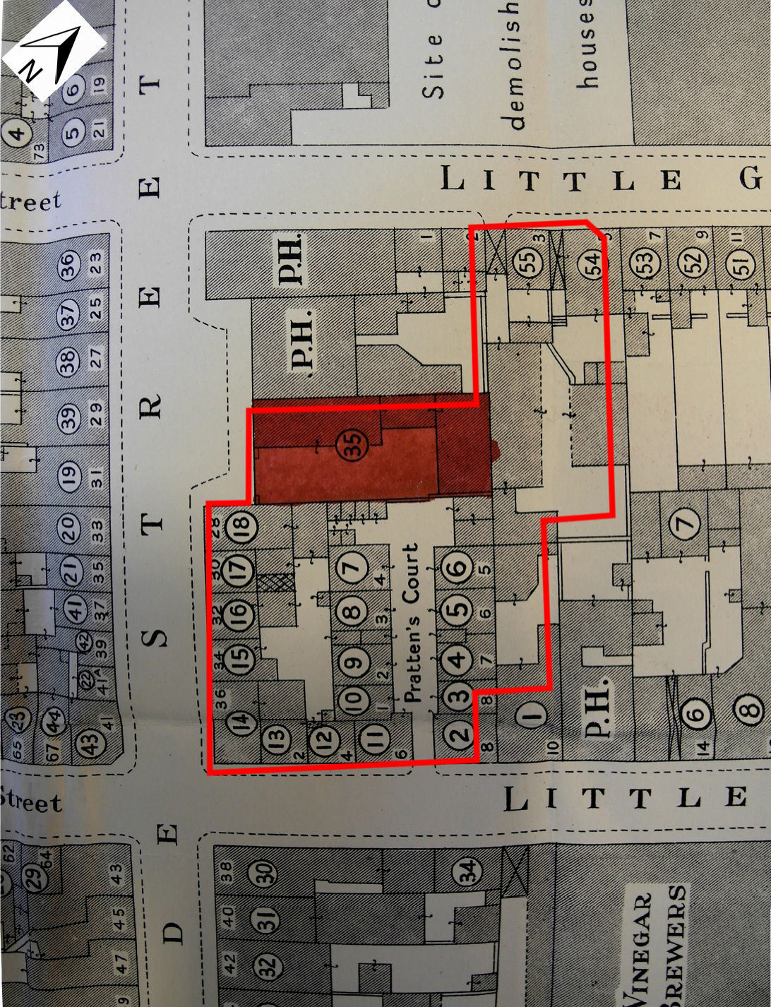
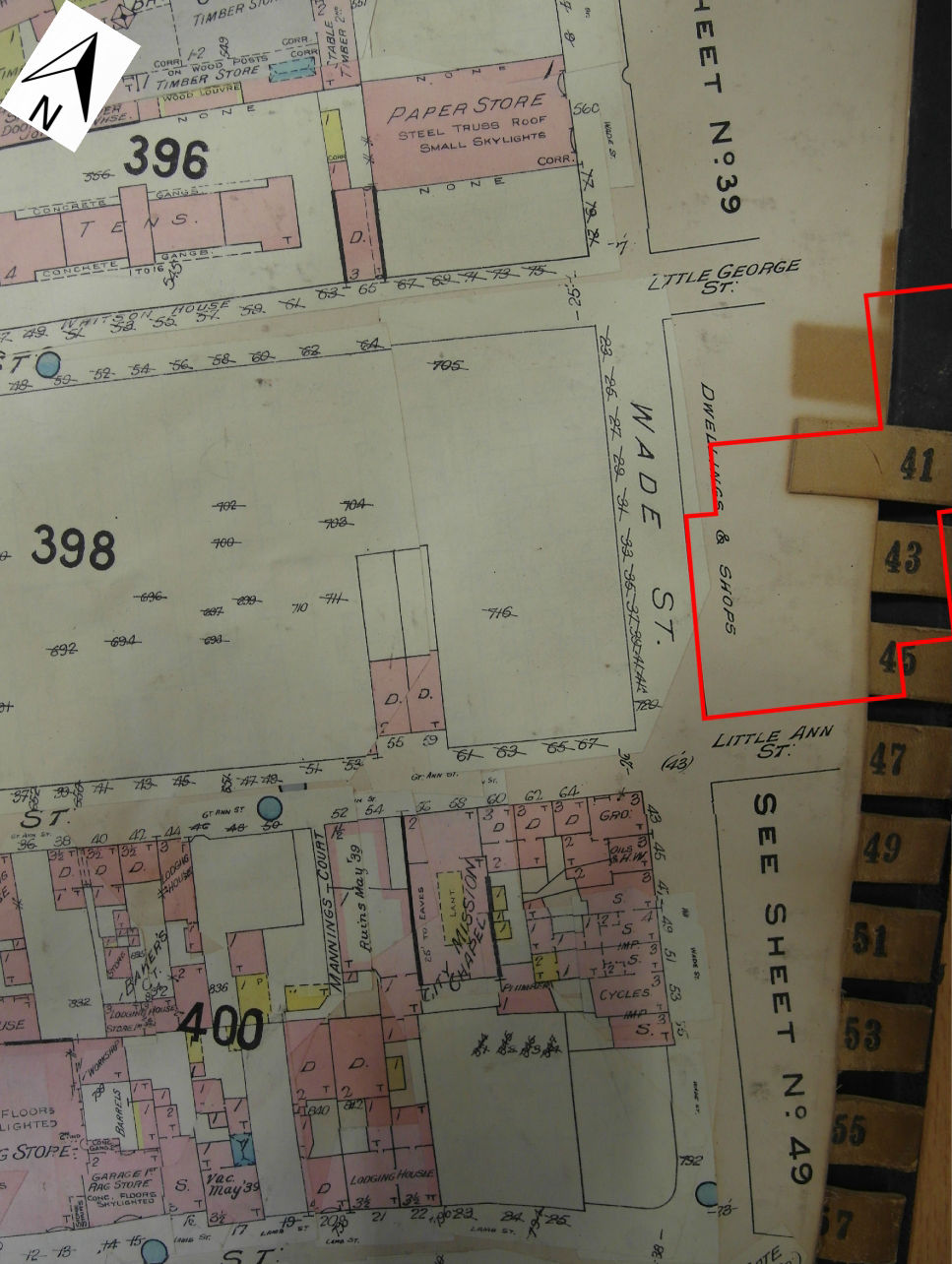
Bristol researchers in general are fortunate in that they have available to them a major, large-scale cartographic source covering the late 19th and into the first half of the 20th century. These are the Goad insurance plans housed at the Bristol Record Office (35033; 40904; and 43885). Regrettably, however, for reasons that are not entirely clear, this key source fails in this specific instance, because it seems as though none of the properties actually within the excavation site, indeed in the entire block bounded by Wade Street, Little George Street, Little Anne Street, and Eugene Street, were recorded on any of the Goad maps; the point is made clear by Figure 10. Since even the earliest of the Goad maps (BRO 40904/2) was subject to revision up to 1939, a reasonable assumption might simply be that the entire block containing the excavation site had by that date been almost entirely cleared of buildings, following the compulsory purchase process for the area that is documented in BRO Modern Records 8160A. However, as Figure 10 indicates, although it shows no detail whatsoever, the Goad revision up to 1939 does label the north-eastern Wade Street frontage, bounded by Little Anne Street and Little George Street, with the caption 'Dwellings and Shops'. This suggests very strongly that on the eve of the war, at least this part of the street block remained in use and occupied, and for whatever reason(s) the buildings were not recorded in detail; perhaps because they had already been earmarked for removal, a process to which the advent of war put a temporary halt. 16
Properties all around the excavation site are, however, recorded on the Goad maps, and most notable is the appearance of 17 Wade Street, shown clearly on the map as being of three storeys, fronting the road, but with two later extensions of two storeys and one storey respectively as one moves away from the street frontage. The roof was tiled, and the premises were in dual use as a shop and dwelling. Oddly, no. 17 appears on the map revised up to 1961 (BRO 35033/2a), but not on that revised only up to 1939 (BRO 40904/2), which has this number crossed out and its site left blank. There could be any number of reasons for this, but perhaps the premises were simply not insured at the earlier date. The survival of 17 Wade Street as a standing building today seems remarkable, along with the public house, the Swan With Two Necks, in Little Anne Street.
It is apparent then, that the clearance of the block, of which the excavation site forms merely the south-west corner, took place in fits and starts, rather than being a wholesale removal carried out over a relatively short space of time. By the early 1950s however, even before the site had been fully cleared, a certain amount of rebuilding had already taken place; a new building (since demolished) appears to have been erected just south of the former Sportsman's Arms pub, now the Al Baseera building. Interestingly, the areas to the east and north of the site, although not the site itself, had a predominantly industrial character at the time of the local authority compulsory purchase map, with a factory, malthouse and warehouse shown to the south of Little Anne Street, and an oil and chemical (colour) works to the north of Little George Street. This fact may give some indication of at least part of the original rationale behind Wade's development venture on his Lamb Ground/Crotwells estate, as at least in part a scheme to provide labour for nascent industrial concerns in the immediate area. Leech remarks on how both Wade himself and other contemporary development promoters were:
prominent members of the Quaker elite, many of whom were closely linked to various industrial concerns. The houses built in the new streets of these developments were within easy walking distance of a number of Quaker-owned industrial concerns … possibly the houses of these new developments accommodated some of the workers in these various industries. If so, they would have been a vehicle for recycling the capital invested in these industries, through workers' wages paying rents, which then became landlords' profits (Leech 2014, 57).
We have already indicated that the defining characteristic of this little development was that it at least appears from the outset to have been a working-class, artisanal community, but with a planned, grid layout of streets, and in fact it could be said that of the first, early 18th-century building phase, it is actually the street plan itself that is the earliest surviving artefact.
However, having been razed in the course of so-called 'slum clearance' in the years on either side of the Second World War, the study site was effectively frozen at the point at which all surface trace of the occupying buildings was removed, but while redevelopment subsequently proceeded apace all around it, this site remained untouched, apart from occasional tampering with the surface, such as some ground reduction since 2000 for car parking.
It is the planned, artisanal nature of the site and its wider context that presents the primary interest, and indeed it has been compared with the well-known early industrial housing in the Trinity area of Frome (by Roger Leech - quoted in Smith and Erskine 2000, 8). Wade Street and its environs had clearly already become a community of note by the early 18th century, at which time no less a figure than Daniel Defoe observed how
There is one remarkable part of the city where the liberties extend not at all, or but very little outside the city gate. Here and nowhere else, they have an accession of new inhabitants; and abundance of new houses, nay some streets are built, and the like 'tis probably would have been at all the rest of the gates, if liberty had been given (quoted in Leech 2014, 41).
12. This brief review of the historic map evidence is site wide. However, for a rather more detailed analysis of two specific properties within the site boundary, relating to pipe makers who were working there in the 19th century, see the specialist report on the clay tobacco pipe material from the site, Appendix 3.←
13. It is unclear why the entire area of the St Jude's development was apparently not rated for tithe. It is unlikely to be anything to do with the relatively late date at which the development was established – by the mid-1840s, all of the area encompassing the later Edward, Harleston and Winsford streets, a few hundred metres to the north-east of the excavation site, was rated for tithe, and yet in 1828, at the time of Ashmead's first edition map, this whole area on the eastern side of Pennywell Lane, was a large, triangular piece of open and completely undeveloped pasture ground, with a few (?orchard) trees. If the land on which Wade built his new development had always been tithe free, one reason may have been that it had at some point belonged to a monastic or other collegiate religious institution, which might render the land exempt from tithe; farmland newly assarted from woodland, or drained and reclaimed from fen or marsh, was also very often considered to be quit of tithes (Aston 2000). In the case of the excavation site and its environs, there does not at present seem to be any evidence either way.←
14. This fact has been well known to professional archaeological surveyors for some time. See for, example, Stuart Ainsworth's comments during the Time Team survey of the Boulton and Watt works at Soho, Birmingham; Time Team Series 4, Episode 3, first broadcast 19 January 1997.←
15. A good example of which would be Context 1114, seen in section underneath the cobbled surface in Area A of the site.←
16. We should note, however, that the Goad map revised up to 1961 (BRO 35033/2a) also shows this same part of the north-eastern Wade Street frontage between Little George Street and Little Anne Street, and containing the excavation site, as 'Dwellings and Shops'. This would seem to indicate that even as late as 1961, standing buildings, used and occupied, survived here. It is possible that this is explained merely as a failure of revision in this part of the map; however, it is borne out to some extent by the fact that an OS 1:1250 map revision of 1951 clearly shows numbered, standing buildings along this part of the Wade Street frontage, suggesting continued occupation and use. Numbers 38, 36, 30 and 28 Wade Street are depicted. Numbers 34 and 32 are still shown as standing, but are not numbered. The Ship Inn at 18 Wade Street, the Sportsman's Arms occupying 20 and 22 Wade Street (but numbered only 20 on this map), and the Swan With Two Necks at 12 Little Anne Street, all survive, as did, at this late date, the property next door to it to the south-west, 10 Little Anne Street. The entire north-eastern two-thirds of the site had, though, been cleared by this date, including of course Pratten's Court. Later OS maps show that the site had been fully cleared by 1963, so this may suggest that the Goad revision to 1961 was correct to show 'Dwellings and Shops' still standing on the south-western part of the site in that year. Mason remarks that the major phase of demolition along Little Anne Street, Wade Street itself, and within Pratten's Court, seems to have occurred between 1949 and 1961 (Mason 2013, 3-4).←
Internet Archaeology is an open access journal based in the Department of Archaeology, University of York. Except where otherwise noted, content from this work may be used under the terms of the Creative Commons Attribution 3.0 (CC BY) Unported licence, which permits unrestricted use, distribution, and reproduction in any medium, provided that attribution to the author(s), the title of the work, the Internet Archaeology journal and the relevant URL/DOI are given.
Terms and Conditions | Legal Statements | Privacy Policy | Cookies Policy | Citing Internet Archaeology
Internet Archaeology content is preserved for the long term with the Archaeology Data Service (ROR). Help sustain and support open access publication by donating to our Open Access Archaeology Fund.