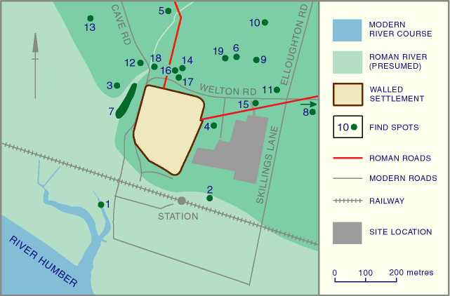
Fig.2: Archaeological Sites and Finds from Brough-on-Humber (clickable map)
Brough-on-Humber was first subject to significant archaeological investigation between 1933 and 1937. Dr Philip Corder and Rev. Thomas Romans identified a Roman town of about 5 hectares, apparently enclosed by a turf rampart during the Hadrianic period, and by a stone wall towards the end of the 2nd century. An earlier rampart was attributed to military activity in AD 71 (Corder 1934; 1935; Corder and Romans 1936; 1937; 1938).
The second main series of excavations within the town took place during 1958-61, under the direction of John Wacher. This work largely confirmed the findings of the previous phase of excavations. New information included evidence that the early military activity was early Flavian in date, and comprised a temporary camp with an annexe. This was replaced by an auxiliary fort, which was abandoned around AD 80. The fort was reoccupied for a short time during the early Hadrianic period, but it was soon replaced by a walled settlement, which was occupied until around the middle of the 4th century (Wacher 1969).
View Wacher's Phasing
More recent investigations, mainly carried out by the East Riding Archaeological Society, have provided information on the extra-mural settlement. In particular, excavations carried out at Cave Road in 1977-78 and Petuaria Close in 1980 unearthed evidence of occupation north of the walled area.
An aerial photograph appears to show a Roman road running east-north-east from Brough, about 1km from the village. This has been interpreted as the continuation of the road that exits from the east gate of the walled settlement.
Fig.2: Archaeological Sites and Finds from Brough-on-Humber (clickable map)
1. Ellerker Haven. SE 936265
Two Roman coins, found in the river bank [foreshore?] mud in 1951.
Loughlin and Miller 1979, 28,
SMR record 1339.
2. Randsfield Avenue. SE 939265
Romano-British coin.
SMR record 3232.
3. North-west of Haven Garth,
Brantingham parish. SE 936269
Tessellated pavement [probably on the opposite bank of the inlet west of the
walled settlement], observed in 1929.
Loughlin and Miller 1979, 24,
SMR record 2945.
4. Wrygarth Avenue. SE 939267
Romano-British extra-mural occupation, south of the Roman road.
SMR record 12963.
5. Cave Road. SE 937271
Stone-lined Roman burial (interpreted as a priest) with two bronze sceptres and
an iron bucket, on the western side of the Roman road to York, found in 1936.
Also other burials from at least two locations nearby.
Corder and Romans 1938.
6. North of Welton Road. SE940270
Five Romano-British lead pigs, and pottery.
Loughlin and Miller 1979, 26
7. West of Station Road. SE 936268
Cobble surfaces, presumed to have been associated with quays to the west of the
walled area.
Wacher 1969, 71f;
SMR record 2944.
8. No.1 Police House, Welton
Road. SE 945269
Stone and mortar floor and Romano-British pottery, found in 1958.
Loughlin and Miller 1979,28
9. North of Welton Road. SE
941270
Two mortar floors and Iron Age pottery, found in 1949.
Loughlin and Miller 1979, 26
10. West of Elloughton Road. SE
941271
Two inhumations with ironwork (cart accessories) and much pottery, found in
1948.
Loughlin and Miller 1979, 26
11. Corner of Welton Road and Elloughton
Road. SE 942269
Mortar floors, hearths, a Romano-British burial, lead pigs, pottery and coins.
Loughlin and Miller 1979, 26
12. 5 Cave Road. SE 937270
Timber buildings, 2nd century pottery and a 3rd century coin.
Wacher 1969, 73.
13. Cave Road. SE 937270
Evidence for Romano-British settlement found during archaeological excavations,
1977-78.
Goodburn 1978, 427, Goodburn
1979, 287
14. Petuaria Close. SE 938270
Evidence for Romano-British settlement found during archaeological excavations,
1980.
Frere 1986, 386,
SMR record 12049; P. Halkon pers. comm.
15. Welton Road. SE 941268
2nd century bow brooch, found in a ‘garden south of the Welton Road about
200 yards from the [walled] site' prior to 1935.
Corder 1935, 15, fig. 8
16. 3 Petuaria Close. SE 939270
Archaeological excavations in 1984 revealed a wall and a hearth (site code BPC
84).
SMR record 9854
17. 4 Petuaria Close. SE 939270
Roman pottery found.
SMR record 16377
18. 4 Cave Road. SE 937270
Romano-British artefacts found.
SMR record 12508
19. Haven Avenue/former Grange Farm,
Elloughton Road. SE 940270
Floors, disturbed burials, pottery and artefacts found in 1944. Probably
associated with a floor and four lead pigs found immediately to the west in
1940. Also 1st-2nd century pottery found in a watching brief at 14 Haven
Avenue.
Corder and Richmond 1942, 28; Greene
1945, 249; watching brief accession code
HAB92
© Internet Archaeology
URL: http://intarch.ac.uk/journal/issue9/brough/intro2.html
Last updated: Tue Nov 28 2000