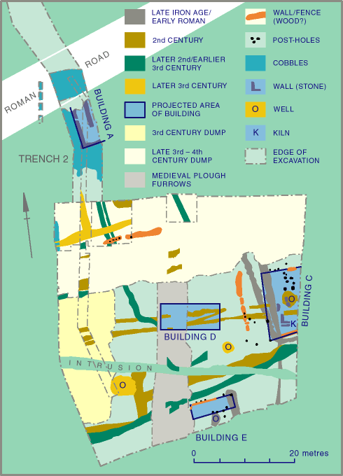
Fig.4: Trenches 1-2, D-G, Phase plan (clickable map)
Fig.4: Trenches 1-2, D-G, Phase plan (clickable map)
The earliest features in Trench 1 (Fig.4) were (unexcavated) ditch fills 1372 and 1585, which were 1.0-1.3m wide. They probably formed the south-west corner of a field or large enclosure. A single post-pit (1569) was observed within this enclosure. At the south end of Trench 1 was another ditch, 1456/1552, which was 2.0m wide but only 0.3m deep and had a rounded terminal (Fig.22). A coin of Titus (79) (under Vespasian), minted c.AD 77-78 was recovered from this ditch. The ditch was recut, but on a smaller scale only 0.3m wide (1441). To the west of this ditch was a circular well or watering hole (1489), which was 2.4m in diameter and at least 1.2m deep.
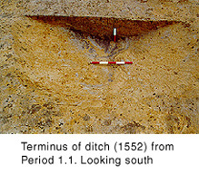
Figure 22
In Trench I (Figs. 5 and 17), a large ditch was cut into the natural sandy subsoil (156). It was 2.5m wide but only 0.7m deep, and was aligned east-west. The presumed eastern continuation of 156 in Trench 3 was not observed, perhaps because the light grey sandy fill was difficult to distinguish from the undisturbed natural deposit. Six metres to the north was a small east-west ditch with a rounded east terminal (123), which was subsequently recut slightly to the north (127). These ditches were undated.
Portions of a small ditch were observed 24.0m south of Trench 1 (5002 and 5018) in two adjacent house plots during the 1994 building work (Fig.11). It was a small feature with a concave profile, and contained a distinctive light grey sandy fill (5001). This ditch appeared to form a sub-square feature a little more than 6.0m square. It is tentatively interpreted as a roundhouse or haystack eaves drip. About 30.0m south of this enclosure ditch were two small ditches with concave profiles (5004 and 5007). They were at least 7.0m long, aligned south-west/north-east, 6.0m apart, and had rounded north-east terminals. These ditches appear to form the north-east end of a droveway (Fig.12).
In the south-east corner of the site were two other ditches, which contained a light grey sandy fill. The larger was observed in Trenches A (Fig.14) and B (Fig.15), and in a 1994 sewer trench (Fig.13; 5033), over a distance of 41.0m. It was 1.7-2.1m wide and at least 0.5m deep, and followed a sinuous north-south course. Another large ditch, 2.5m wide by at least 0.6m deep (5037), was observed immediately west of 5033. It was not observed to the north or south and may have been a recut of 5033. A smaller ditch immediately west of 23 in Trench A (36) was observed to the east of 5033 in the sewer trench to the north (5029), which suggests that it was aligned slightly east of north and was not contemporary with the former ditch. It was not observed in Trench B, although this may have been due to truncation by medieval ploughing.
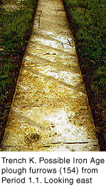
Figure 23
Towards the south end of the site in Trench K were ten plough marks, aligned south-west/north-east (154 and 166-70; fig.23). They were an average of 170mm wide by 70mm deep, and were 0.3-1.0m apart. A single sherd of late 1st to mid 2nd century rusticated ware was found in the fills of these features. Combined with their unusual orientation, this suggests that these plough marks related to Iron Age farming prior to the establishment of a more regular field-system (Fig.18).
All the features in this Phase had distinctive light grey sandy fills, in contrast to the orange sand that formed the top of the undisturbed natural deposits on the site, into which these features had been dug. This suggests that the Period 1.1 features were backfilled before they could become silted, using material brought onto the site for this purpose.
The enclosure ditches 1372/1585 were cut by a ditch aligned north-south (1523). However, where 1372/1585 turned east, 1523 continued southwards. It contained deposits more typical of the fills on the site: a primary, natural fill of orange sand, followed by dark grey-brown silty-loam backfill deposits. To the west were the, unexcavated fills of a ditch with a recut, barely 0.5m wide and aligned north-south (1163-4). It is possible that the ditch layout had been changed, so that they enclosed strips of land aligned north-south. Extensive sandy dumps were deposited east of ditch 1523, perhaps for levelling purposes.
© Internet Archaeology
URL: http://intarch.ac.uk/journal/issue9/brough/siterep1.html
Last updated: Tue Nov 28 2000