Figure 24
This phase marks a major change in the ditch layout, to an east-west alignment. A total of six ditches were observed. They were relatively small, with an average width of 0.5m and a depth of 0.3m. Three of the ditches, in the middle of Trench 1, probably represent three versions of a single ditch. The original ditch (1217, 1574/5, 262/5,1507 and 1581) was first diverted mid-way across Trench 1 (1520 and 1443), so that to the west it ran 2.0m to the south of its former line (275 and 1573). Later, the eastern part of the ditch was also shifted to the south (1579, 1443, 1543 and 1529-31).
The other three ditches were only observed as short lengths in the base of the service trench on the west side of Trench 1 (1242, 1258 and 1269). It is not clear whether they were contemporary with the ditch complex in the middle of Trench 1, in which case they would have divided the land into narrow east-west strips, or whether they belonged to different phases. Small post-pits, found adjacent to the ditches, probably represent fence lines rather than buildings.
There was a small concentration of features towards the east edge of the trench. Immediately north of ditch 1529-31 was a well or watering hole, 3.0m in diameter and at least 0.5m deep (1570). To its north were two post-pits, 1384 and 1416. The former had a limestone post-pad in its base, and there were traces of a post-pipe, around which two large limestone fragments had been packed. There were no other structural remains in this vicinity, so they may represent a superstructure associated with 1570. Immediately north of the post-pits was a pit cut (1439), which was 1.2m square but only 0.3m deep. It contained sandy fills, indicative of backfill of an open feature. Part of a small, shallow pit was observed in a sondage at the north-east corner of the trench (1005); it also had a sandy fill.
This activity was undated, but is thought to date to the late 1st century on stratigraphic grounds.
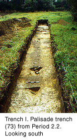
In Trench I, the Period 1.1 ditches were cut by a narrow, linear cut at least 17.5m long and around 0.6m wide, aligned north-south (73) (Fig.24).
Figure 24
Post impressions in the base of the cut, and concentrations of limestone fragments, suggest that this feature held timber uprights, packed with stone, at approximately 3.0m intervals (Fig.25).
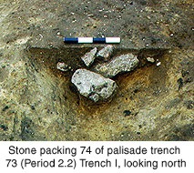
Figure 25
It is likely to have been a palisade. The stratigraphic evidence suggests a late 1st or 2nd century date for this feature. It contained some late 2nd or earlier 3rd century pottery, but this could have been introduced during the dismantling of the structure.
The stratigraphically earliest feature in Trench 3 was a largely unexcavated ditch aligned north-south (fills 3006/3014), which measured 1.5m wide on average. It lay 2.0m east of the alignment of 73. This arrangement could represent a defensive ditch in front of a palisade. In Trench 4, unexcavated dumps of sandy loam, which were deposited on the original ground surface (4012-15), could be the remains of a rampart that incorporated the palisade.
At present, there are two possible explanations for the existence of defences to the east of the walled area. The first is the Flavian camp, which is believed to have been associated with the initial military campaign in the area c.AD70 (Wacher's Period IIa). Corder recorded a Flavian rampart of similar construction, north of the east gate of the walled area (Corder & Romans 1938, 15f.; Figs.2-4); the palisade trench held posts, perhaps jointed to a sill beam, which formed the support for the breastwork on top of the rampart. This rampart was subsequently interpreted by Wacher as an annexe to the later Flavian fort (his Period IIB; Wacher 1969, 8). The second candidate is the original, earlier 2nd century ‘town' rampart (Wacher's Period V). A ditch and possible turf rampart was found by Wacher between the western defences of the Flavian fort and the Period VI town wall, and was interpreted as the original west defences of the town (Wacher 1969, 26f.; fig.11). Corder found the remains of buildings beneath the Period VI east wall, which indicated that the Period V settlement extended further east than its successor (Corder 1938, 28f). However, these defences were more substantial than those presently under discussion; the ditch was in excess of 3.0m wide.
Also of 2nd century date (or a little later) was a human adult inhumation (3004) (Fig.26), which lay 3.0m east of ditch 3006. It was in a cut (3005) which had been severely truncated by medieval ploughing.
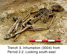
Figure 26
© Internet Archaeology
URL: http://intarch.ac.uk/journal/issue9/brough/siterep2.html
Last updated: Tue Nov 28 2000