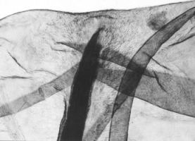

Figure 10: Waterlogged top of a kernel of barley. Photo BIAX Consult.
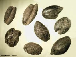
Figure 11: Charred grains of barley. Photo BIAX Consult.
The preservation conditions for waterlogged botanical remains in the Dutch River Area are variable. Pollen, waterlogged plant remains (Fig. 10) and wood have only been preserved in deep, water-satiated features such as wells and sediments in residual channels and low-lying parts of flood basins. The preservation of charred plant remains (Fig. 11) also varies, but this is mainly a result of the degree of charring by the fire and the deposition of the plant remains afterwards. While the chance of finding uncharred remains is predictable, the chance of finding charred remains is not, since this is highly dependent on human actions.


Figure 10: Waterlogged top of a kernel of barley. Photo BIAX Consult.
Figure 11: Charred grains of barley. Photo BIAX Consult.
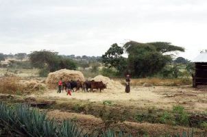
The material included in this study consists of botanical macro remains, wood, pollen and other micro-fossils. Each of these material categories has its own research questions, collection strategies and research methods. Botanical macro remains are used in this study to get some idea of the agrarian economy (Fig. 12) and the location of arable fields, pastures and meadows. The material was collected from ground features during archaeological excavations. The wood mainly derives from the lowest parts of the wooden linings of wells and from their fills. Wood has also been found in sediments of residual channels.


Figure 12: Threshing cereals with the aid of cattle in Ethiopia. Photo L.I. Kooistra.
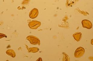
Figure 13: Pollen from oak. Photo L.I. Kooistra.
The wood used in the construction of buildings, stables, granaries and sheds had decayed. The results of the analysis of the wood provided information on the presence of trees on the streamridges, levees and in the flood basins. Palynology was used in this study to gather information on land use and vegetation (trees versus herbaceous vegetation) of the various landscape elements (streamridge, levee, residual channel and flood basin). The palynological material (Fig. 13) derives from natural sediments in the flood basins and the residual channel. In addition, pollen samples were collected from the fills of wells and deep pits.
For the key sites in Tiel-Passewaaij, botanical macro remains have been analysed for the southern settlement Passewaaijse Hogeweg. For this site, samples from c. ten features, such as ditches, wells and pits, were analysed (Fokma 2005), as well as c. ten post-holes of a burned granary (Kooistra and Heeren 2007). As elsewhere in the Dutch River Area, emmer wheat (Triticum dicoccon) and hulled barley (Hordeum vulgare var. vulgare) were the main cereals. Oat (Avena) and millet (Panicum miliaceum) were found several times. Pulses and other crops were only found a few times. Of all the wild plants present, over 60% grow in dry to humid, moderately fertile soils. These plants can nowadays be found in open vegetation such as that of arable fields and settlements. Because representatives from heavy clay soils are absent in this group, it is assumed that the plants grew on streamridges or levees. Nearly 30% of the plant species found grow in closed vegetation. These plants are nearly all dependent on humid to wet conditions. It is assumed that these are plants from humid to wet grassland and marshy vegetation. Considering the humid to wet conditions, these plants could be found in residual channels and flood basins. The remaining 10% of wild plants are representatives of woodland. With one exception, the woodland plants are not dependent on specific wet or dry conditions. The exception is the alder (Alnus), which is usually found in wet habitats. For Passewaaijse Hogeweg, wood from two large baskets (with a diameter of around 1 metre) has been analysed. The baskets were found at the bottom of a well, and are made from one-to-two-year-old willow twigs. Willow (Salix) prefers wet clay soils. If the baskets were made locally, the wood was probably collected from the flood basins and river banks. There were no suitable locations for palynological research in this site, so no general information on the vegetation history could be gathered.
Like Tiel-Passewaaij, Geldermalsen-Hondsgemet was located in the middle of the Dutch River Area. Palynological analysis of natural sediments from before the Roman period demonstrates that the landscape was already used by people. The flood basins were covered in sedge and reed marshes, willow and alder. The dry parts of the landscape (the crevasse sediments) contained few trees. The landscape was very similar in the Roman period. Wood analysis shows that willow and alder are most common. This seems to indicate that the flood basins, especially, were relatively rich in trees and shrubs. The same crops were grown in Geldermalsen-Hondsgemet as were found in Tiel, although millet was not present in the Middle Roman period (AD 70-270). Some 40% of wild plants grew on arable fields or in the settlement on the crevasse sediments. More than 50% of wild plants represent grasslands and marshes in the flood basins and residual channel. Just under 10% indicate woodland, mainly in the flood basins or on the river banks (Kooistra 2009).
Kesteren-De Woerd was located on a crevasse, close to the River Rhine. From the late 1st century, the site was thus located on the border of the Roman Empire. The results are similar to those of the settlements above, but there are some differences. In Kesteren-De Woerd, spelt wheat (Triticum spelta) was found. It is not yet clear whether spelt wheat was cultivated locally or supplied from the Roman castellum nearby. Several other imported species such as damson (Prunus domestica subsp. insititia) and fig (Ficus carica) were present. These fruits were probably imported, although local cultivation is not impossible (Kooistra and van Haaster 2001).
Results from two other sites are used in this study: Houten-Tiellandt (Kooistra 1996) and Wijk bij Duurstede-De Horden (Lange 1990). These two sites were located on streamridges of the River Rhine, in the north-west of the Dutch River Area. The crop spectrum is similar to that of the other settlements. As in Kesteren-De Woerd, there were several occurrences of damson in both sites.
Although surplus production played an important role in the period that this study focuses on, it falls outside the scope of this article. The landscape around Tiel-Passewaaij and the way in which its inhabitants used it form the main topic of this study.
© Internet Archaeology/Author(s)
URL: http://intarch.ac.uk/journal/issue27/5/2.4.html
Last updated: Tue Nov 10 2009