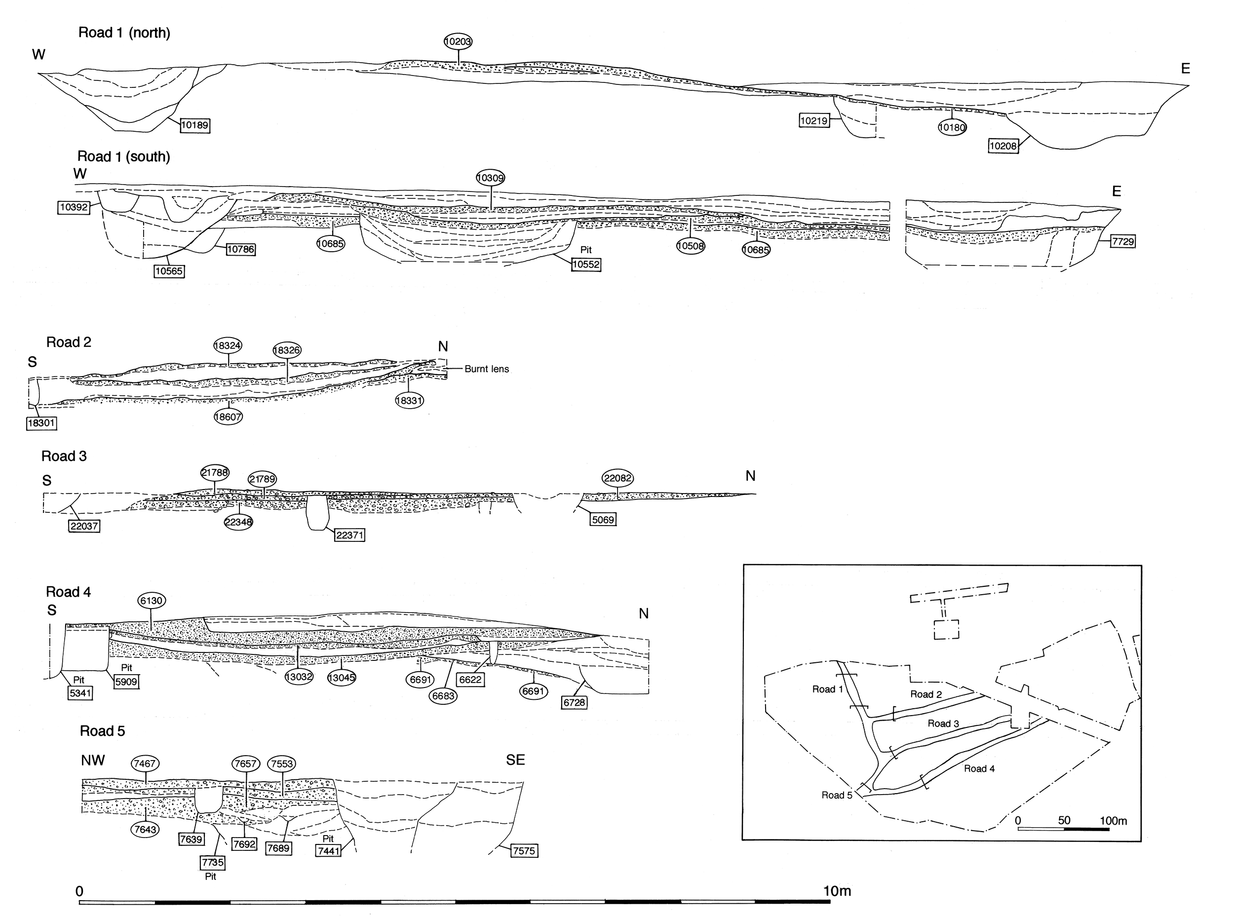
Physical remains of the road itself are only encountered in Excavation Areas H and J, though a slot was also dug across its projected course in Area L (Figure 58, Figure 69 and Figure 70). It seems apparent that Road 4 continues to function throughout Period 3, but the evidence for much of its extent is inferred, there being little sign of maintenance to the road itself. In the absence of road fabric demonstrably datable to Period 3, this section primarily contains and relies upon consideration of the ditches that define its course and signal its continuance during this period. It is noteworthy that ditches are only recorded along its northern edge. The following road sequence descriptions are ordered from west to east, from perceived settlement centre to periphery.
Where investigated just east of its junction with Road 1 (in Excavation Area H), no surfaces attributable to Period 3 or later are encountered. The Period 2B roadside ditch 25255 (Group 134), presumed to flank an early phase of Road 4 (unexcavated/unsubstantiated at this point), may continue in use into the early part of this period. However, it is silted up by the later 1st century AD and its line is re-established by re-cut 25254 (segs 6868, 6728, 6646 Group 379). As denoted by 6868, this replacement is in excess of 3m wide and 0.8m deep.
Although the Area H roadside investigation did not extend far enough south to determine either the edge of ditch or its relationship with the various surfaces of Road 4, this is clarified in a further trench immediately to the east in which the south edge of the ditch is recorded as 6728. This part of the ditch does clearly cut through the early layers of Road 4. The ditch seems to denote a southward shift, most probably resulting in the slight narrowing of Road 4.
While the westwards extent of this ditch is not located, its eastern terminus is excavated as ditch segment 6646. Although severely truncated, this broad ditch has a roughly square end. In all, this roadside ditch is traced for some 15m. It is likely that its west terminal is located at the junction of Roads 1 and 4 and that the complete ditch is therefore no more than 20m long.
Ditch 25256 (seg. 6713 Group 380) is a similarly broad, shallow cut, 2.5m wide and 0.5-0.6m deep, which also runs along the north side of Road 4 further east of 25255. Only the rounded, tapering, western end of this ditch is excavated (seg. 6713). The ditch, although cutting the end of 25254 (see Group 379), appears closely connected, sharing the same point of termination; perhaps 25256 is a development or replacement of the earlier ditch. Both ditches appear to be re-cut, 25256 at least twice, so it is possible that originally there was no overlap and both features were contemporary. There could even be an entrance gap between them, which is subsequently filled in by re-cutting and extension.
Ditch 25256 cuts one of the early make-up layers of Road 4, providing further evidence of its narrowing or southwards shift and suggesting at least a broadly contemporary existence with 25254.
Stake- and post-holes (e.g. Groups 485 and 487) in the vicinity of this frontage indicate that there are at least some minor structures present at this time, but it is difficult to envisage any large buildings, and it is impossible to get any reliable impression of their nature from the recorded remains.
Substantial, possibly rectangular, pit 6516 is positioned between roadside ditches 25254 and 25256, cutting the end of the former and being truncated by the latter. This would perhaps indicate that the replacement of this boundary is not necessarily rapid. However, pit 6516 could possibly be the misconstrued terminal of a precursor ditch of 25256, though it contains no dating evidence to help substantiate this.
Following the abandonment and infilling of roadside ditch 25254, and the encroachment of silts along the roadside (see OA19), the top of the ditch and adjacent cambered roadside are levelled off with make-up layers 6664 and 6665. A relatively thin (0.07m) layer of compacted gravel 6653 is laid on top. As excavated, this roadside surface extends just south of the former line of the underlying ditch but may originally have extended further over the north side of Road 4. This episode appears to represent a narrowing of the road and a building up and resurfacing of the interior of OA19 occurring some time around the mid-2nd century. However, it is difficult to identify this same episode elsewhere, either along the roadside or northwards across the interior. It appears that the surfaces previously laid across the interior of OA19 in Period 2B continue in use, presumably being repaired and maintained in this early Roman period. It is likely that gravel surface 6653 constitutes such secondary activity, as do deposits 6674 and 6908 that spread into the adjacent OA19.
On the south side of the road, gravel deposits 13045 and 5579 constitute the main surfacing episodes, along with associated levelling, make-up and bedding layers. Minor patches of resurfacing probably merely indicate subsequent maintenance. Road surface 13045 is at least 5.4m wide, and probably as much as 8m.
Further east, though still within Excavation Areas H/J, this same surface is recorded as 16519 and 16562 and bears evidence of wear in the form of wheel rut 16520 and a possible pot-hole, both of which are repaired. Surface 13045 appears to mark the abandonment of a cambered surface and its replacement with a concave surface. Whether this is deliberate or not is uncertain, although this change in construction seems to coincide with the incorporation of occasional, relatively large rag-stone or greensand fragments in its metalled surface (waste from the construction of the temple precinct wall?). The latest pottery recovered from Group 381 deposits suggests that at least some of these deposits are laid as late as the second half of the 2nd century AD.
Early Roman resurfacing of Road 4 does not seem to extend much beyond the eastern limit of Excavation Area H, with no trace of further surfaces or Period 3 roadside ditches being identified in either Areas L or M further east. While it may be argued that the original 2B road surface endures, it is as likely that the road becomes more of a track. Interestingly, this may be seen to occur roughly at the same eastward point as is the case for Road 3.
Internet Archaeology is an open access journal based in the Department of Archaeology, University of York. Except where otherwise noted, content from this work may be used under the terms of the Creative Commons Attribution 3.0 (CC BY) Unported licence, which permits unrestricted use, distribution, and reproduction in any medium, provided that attribution to the author(s), the title of the work, the Internet Archaeology journal and the relevant URL/DOI are given.
Terms and Conditions | Legal Statements | Privacy Policy | Cookies Policy | Citing Internet Archaeology
Internet Archaeology content is preserved for the long term with the Archaeology Data Service (ROR). Help sustain and support open access publication by donating to our Open Access Archaeology Fund.