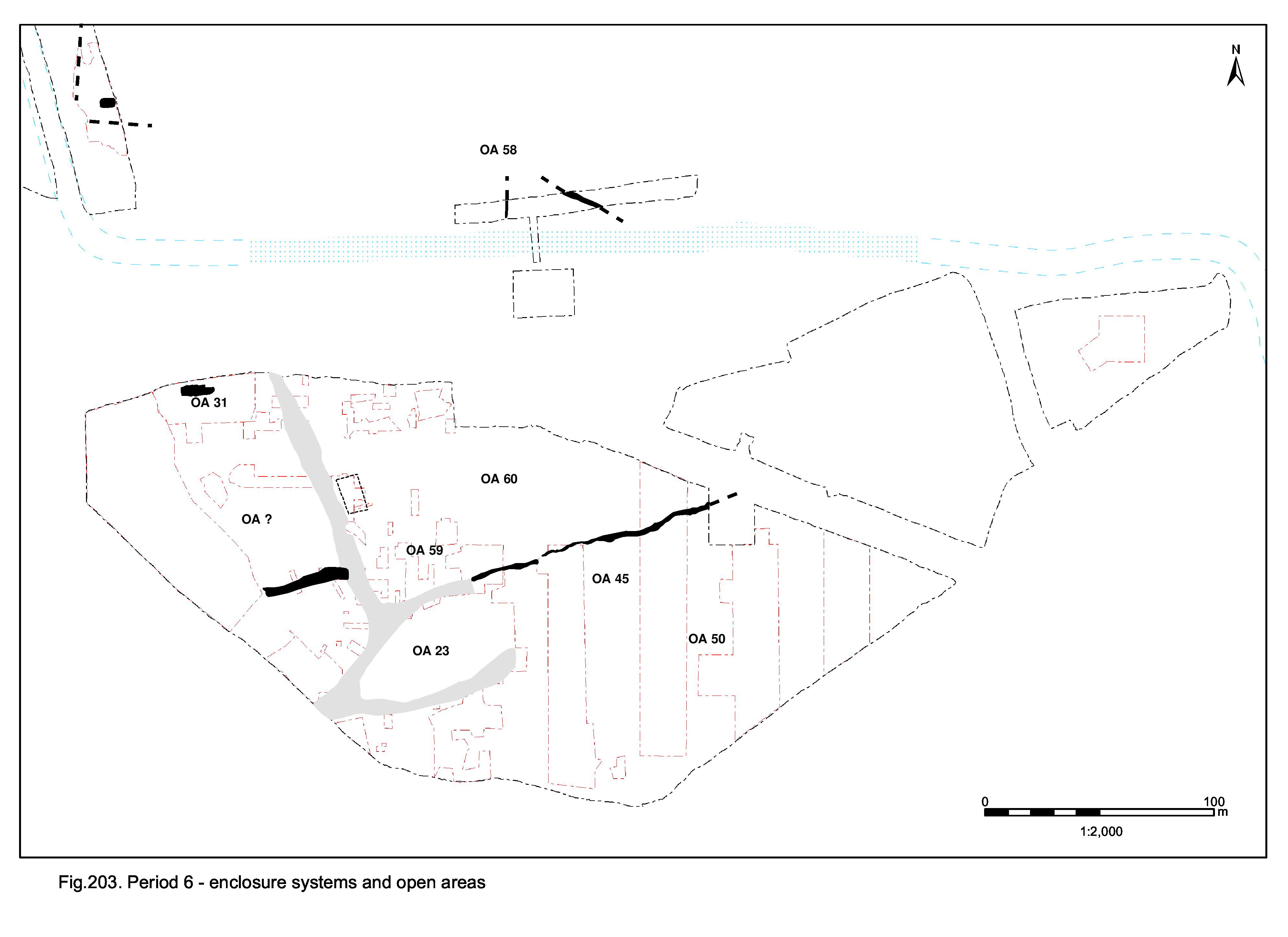
The continued decline and contraction of the Roman settlement toward its core to the west of the area of investigation is evident (Figure 202). The main thoroughfare of Roads 1 and 2 probably survive in an unmaintained state to the end of the Roman period, but all around the infrastructure of enclosures fragments (Figure 203).
It is likely that the settlement core, including the temple precinct, retains a degree of structure. Indeed, the religious focus functions into the late 4th century; the temple cella itself endures and is supplemented by a new small building positioned to its west, deposition of ritual-related items continues along the northern precinct boundary, and the well to the east of the temple now develops into a votive pool. However, changes occur before the end of the 4th century, when the precinct wall and adjacent monumental post are removed and a substantial building placed over the former boundary. Although the relationship between the temple cella and this new structure is somewhat equivocal, it is posited that the imposition of the latter is not entirely unsympathetic. It is likely that the cella endures as a revered ruin, with the new building either supplementing or replacing its function. The latter is more likely; it is tentatively conjectured that the new structure could be an early Christian chapel.
Adjacent OA18 remains part of the settlement core, and a clear distinction between what remains of the Central and Northern Zones is maintained along its northern boundary. However, the occupation and use of this enclosure is indistinct. Beyond the core of OAs 18 and 23, settlement infrastructure further fragments in the late 4th century to the point at which the labels of 'Central, Northern and Southern Zones' becomes fairly meaningless (although this construct is retained in the following text to provide a degree of structure in this report). Lacking meaningful systems of subdivision, the utilisation of the lower terrace outside the contracted settlement focus seemingly continues to decline; crop-processing, manufacture and disposal activities diminish, as does the incidence of buildings. Similarly, the field systems of the Northern hinterland fragment, though there is some hint of continuing occupation north and east of the course of the defunct watercourse.
What remains of the former Roman settlement into the 5th century, and whether there is continuity of occupation into the Early Saxon period, are particularly unclear and problematic questions. Distinct Early Saxon material, almost wholly restricted to very small quantities of pottery in the tops of former Roman settlement remains, is scattered across the lower terrace, though is conspicuously absent from OAs 18 and 23. Two buildings are identified; one located on Road 1 and clearly signalling a disregard for the former Roman settlement, the other positioned toward the lower terrace edge and probably associated with a pit that is deliberately cut into the top of a former well. This activity is perhaps peripheral to an occupation focus that avoids the presumably wholly defunct Roman settlement and is located on higher ground to the north. Three further sunken-featured buildings are located to the north and east of the defunct watercourse and are part of the wider Early Saxon settlement identified from previous and subsequent investigations along Crescent Road. This is the final episode of occupation at Elms Farm and does not appear to endure beyond the 5th century.
Period 6 covers the late 4th and 5th centuries AD. Regarded as a transition period, it is extremely difficult to draw a clear line between what is Roman and what is Saxon. The paucity of diagnostically Early Saxon artefacts among overwhelmingly larger Late Roman assemblages cannot necessarily be taken as denoting an absence of tangible activity of this date. Indeed, many of the late and latest Roman ceramic assemblages are highly fragmented, abraded and include significant residual components. These are very similar to assemblages from identifiably Saxon features, such as sunken-featured buildings, and it is conceded that some deposits may appear superficially latest Roman but are actually later in date, simply lacking the few sherds of diagnostic Saxon pottery. Indeed, one of the SFBs lacks Saxon pottery among its residual late 4th-century assemblage, but on morphological grounds is clearly 5th century. Furthermore, reuse of later Roman settlement remains by Saxon occupants cannot be disregarded. Given the high incidence of small quantities of Saxon pottery within the tops of Roman pits and ditches, it is likely that somewhat different mechanisms for rubbish disposal are adopted and that much of the material culture is spread over the land surface rather than buried. This clearly has implications for survival and legibility and it must be conceded that a significant proportion of this latest occupation evidence may have been machined-off.
Consequently, given all the problems of identification, definition and dating, Period 6 spans the end of the Roman period and the beginning of the Saxon period, though it is not determined how late into the 5th century this final phase of occupation extends.
Overall, there is continued evidence for the contraction of the Late Roman settlement towards its core, which lies to the west of the Elms Farm excavation. With the gradual decline of the road network and the perceived increasing simplification of enclosure systems across both upper and lower terraces, the structure and order certainly of the eastern and northern peripheral parts of the settlement, and probably all of it, fragment and largely disappear by the end of the 4th century or soon after (Figure 203). Within the investigated part of the settlement, and against this backdrop of decline, it is only the religious focus that continues - perhaps even undergoing metamorphosis into an early Christian chapel in the early 5th century.
The distribution of Early Saxon material, however, provides evidence for the emergence of a new settlement focus, to the north-east of the site. The transition from Late Roman to Early Saxon therefore seems to be defined by a clear shift in settlement pattern occurring in the early 5th century, with occupation now predominantly being located to the north of the relict watercourse and on the upper terrace.
In the light of this fundamental decline, change and shift, the continued retention of and reference to the various settlement zones is not particularly reliable but is loosely followed in order to maintain a degree of structure in the site narrative description.
Although side Roads 3, 4 and 5 are surely defunct as thoroughfares by the later 4th century, if not before, the active use of Road 1 is assumed to persist until the end of the Roman period. This continuance does not apparently involve any upkeep and certainly no further resurfacing is undertaken. All the former roads, whether active or defunct, are increasingly encroached upon by accumulating silts that emphasise their increasing neglect or else abandonment (Groups 457, 646, 586). Road 1, and by inference Road 2, finally cease to function sometime in the 5th century when a building is opportunistically sited on the convenient hardstanding provided by the junction of the Roads 1 and 5 remnants (see OA60 Building 61). How far into the 5th century this occurs is not established.
Up until the end of the Roman period, even if not functioning as roads, most of these still constitute something of fossilised boundaries to landscape entities across the lower terrace. However, particularly with the demise of the primary through route of Roads 1 and 2, it is difficult to believe that any functioning settlement structure remains into the 5th century.
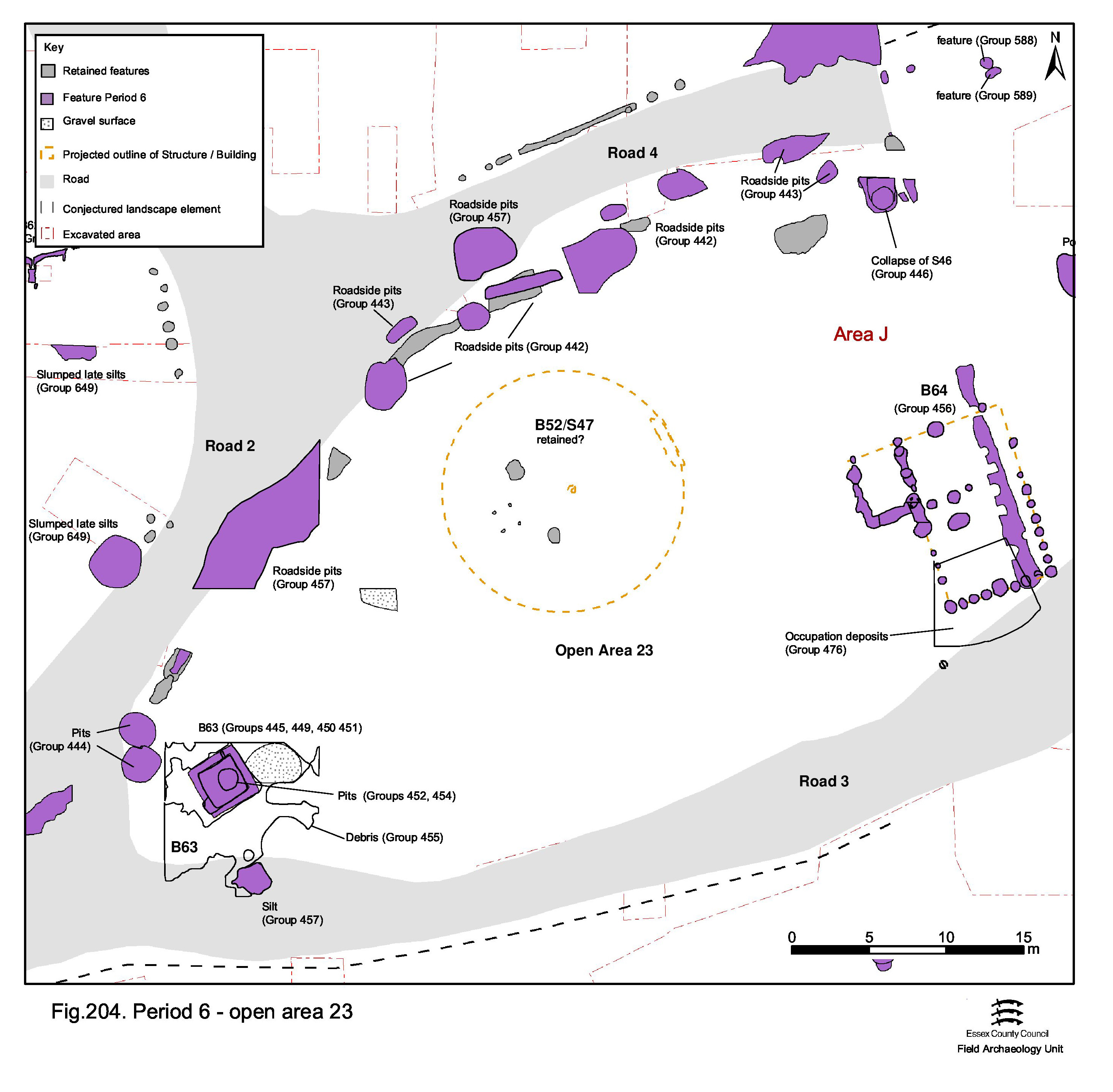
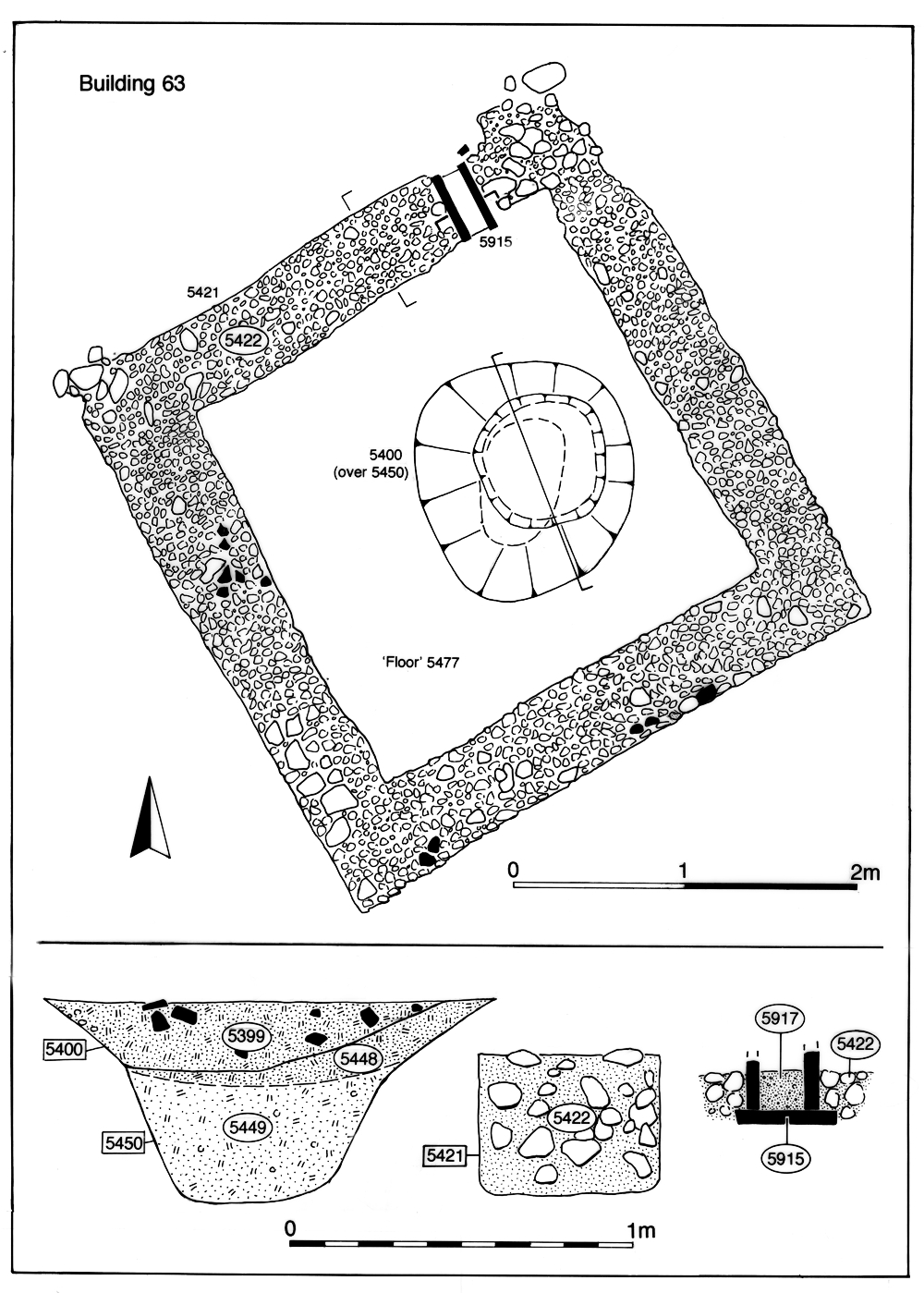
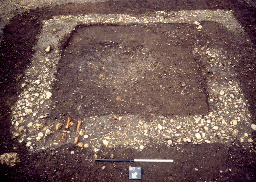
The temple precinct (Figure 204) clearly endures throughout the remainder of the Roman period, retaining its essential form into Period 6 but thereafter undergoing further change and apparent development at a time when much of the eastern part of the settlement seems to be contracting and becoming increasingly depopulated. Temple cella Building 52 initially remains in use, as does monumental post 5232 in the north-east of the precinct. These retained elements are supplemented by the insertion of new, small, square Building 63 (Groups 449-51) (Figure 205). Positioned at what might be the eastern end of the main street of the settlement core, its location may be significant. The function of this short-lived structure is not apparent from its remains, though a tile-lined vent or drainage channel through the wall at ground level might well relate to its use (Figure 206). Internal pit 5450 (Group 452) contains lead splatters, but is a likely secondary insertion and not indicative of the building's use for metalworking. However, considering its location, it could be viewed as a potential roadside shrine used by travellers entering or exiting the settlement.
The continued functioning of the religious focus is perhaps most apparent in the persistence of deposition within pits located along the northern boundary with the remnant of Road 4 - as had been the case in Period 5. Often curiously elongated, and perhaps performing a boundary function in their own right, these latest Roman pits (Groups 442-4) include coins, tools and personal items that may constitute votive offerings. Of note is the presence of face-pot fragments, similar to structured deposition in the Period 5 OA18 northern boundary ditch 25027. The inclusion of fragments of burnt glass, from a bowl and probable cup, may even be the result of discard of temple ritual vessels.
Against this backdrop of seeming continuity and perhaps even enhancement, the Period 5 repairs to the precinct wall are ultimately unsuccessful. Whether the result of collapse or demolition, the wall is removed around the mid- to later 4th century, with its masonry footing being partially robbed then infilled and levelled (Groups 446-7). The monumental post is probably removed at this same time.
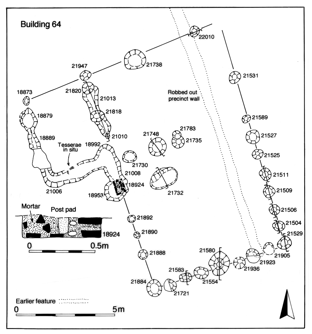
It is likely that the removal of the precinct wall is the catalyst for more significant change within and around the religious focus. Rectangular Building 64 (Group 456) is subsequently built across the cleared wall line (Figure 207). Although its imposition superficially represents a major change in the layout of the eastern part of the precinct, its positioning follows the alignment of the defunct precinct wall and it is perhaps still possible to discriminate between the OA23 precinct to the building's west and OA45 to its east. Furthermore, the new building respects the approach to the temple and may be regarded to some extent as a sympathetic addition to the religious focus. Building 64 is a substantially built structure, with a probable porch toward one end and evidently containing a tessellated floor. An associated religious use is possible, the burial of a complete tazza under its floor having a likely ritual function and the late coin assemblage found in deposits in/overlying the building (Group 476) being comparable to that found in the nearby votive pool (see OA45 below). However, if the temple cella is by now becoming more of a revered ruin than a fully functioning place of worship, Building 64 could be regarded as a replacement. Although the suggestion that this new building is in fact an early Christian church is highly tentative (Vol. 1, Chapter 6), the presence of a Chi-Ro scratched on one of the vessels of the pewter hoard in Period 5 pit 6641 in adjacent OA59 already hints at the arrival of Christianity at the settlement.
Dark brown/black sandy silts (Group 457) build up at the peripheries of Open Area 23 and overlie adjacent parts of Roads 2, 3 and 4. All contain considerable quantities of late 4th century or later finds that either derive from the pits below them or are the product of continuing ritual deposition. However, no activity of Early Saxon date is identified within OA23. With no encroachment upon the footprint of the temple cella evident or its immediate surrounds, it indeed probably stands in splendid isolation as a revered or reviled ruin into the 5th century (Building 63 being removed by the end of the 4th century, Groups 453-5) and may be actively avoided by the Saxon-period inhabitants at Heybridge.
Athough the existence of a southern boundary to OA45 is somewhat vague, its northern limit continues to be defined by the Period 5 sinuous ditch 25260/25262/25077/25078 alongside the remnant of Road 4 (Figure 208). The ditch continues to accumulate material (Groups 652, 651) that includes a significant quantity of building rubble almost certainly derived, at least in part, from the clearance of structures such as the temple precinct boundary wall.
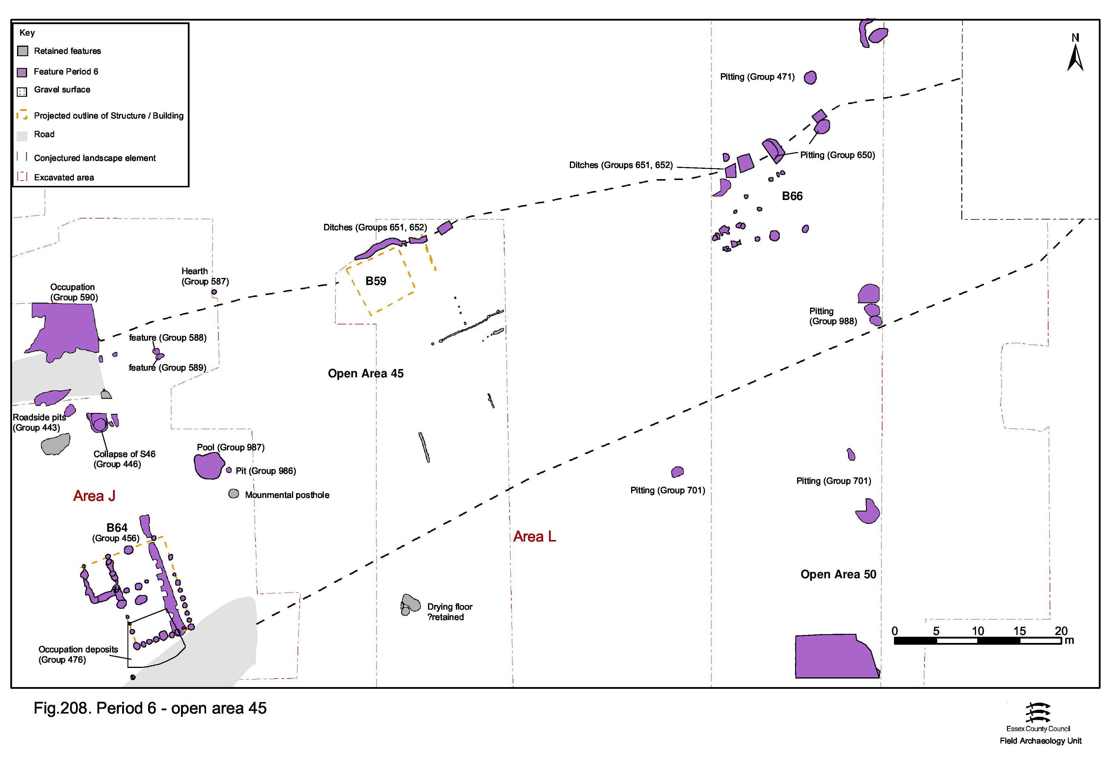
Directly to the east of the temple precinct, the monumental post within OA45 seems to be removed by the end of Period 5. However, a standing pool of water develops or is constructed within the adjacent remains of disused Period 5 well 22210. This pool (Group 987) clearly becomes a focus of votive deposition by visitors to the temple in the final decades of the 4th century, accumulating quantities of coins and jewellery and demonstrating the continued functioning of the temple itself. Newly inserted Building 64 appears to respect the view-line from this votive pool towards the temple entrance. Other shallow pits or scoops in the vicinity seem to be the product of associated individual acts of votive deposition at this location (Groups 986, 588, 589). The deposition of shale bracelet fragments seems to be a particular, and linking, aspect of the deposition in the well and pits.
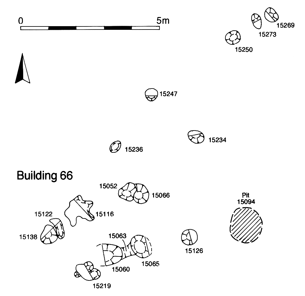
Within the eastern part of OA45, Building 59 may remain in use in conjunction with the fences to the south, though there is no direct evidence for this. To its east, latest Roman pits (Groups 650, 988) are located on the enclosure boundaries, either side of a concentration of post-holes, which may be the site of another tentative structure - Building 66 (Group 474) (Figure 209). In general the pits contain domestic waste and are very similar in artefact content to those of Period 5, although occasional sherds of Early Saxon pottery occur in some. There is no discernible change in the character of occupation between Periods 5 and 6 and the Saxon pottery may simply be accumulating at a later date in slump hollows over Late Roman pits.
Road 5 has already passed out of use during Period 5 and it is surmised that the lack of late 4th-century subdivisions between former OAs 46, 57 and 59 indicates that these are by now amalgamated into a single entity - henceforth identified as Open Area 60 (Figure 210). This newly created enclosure, while potentially subdivided by minor internal partitions, is presumed to extend eastwards from Road 1, and from the ditched boundary with OA45 in the south to the watercourse in the north.
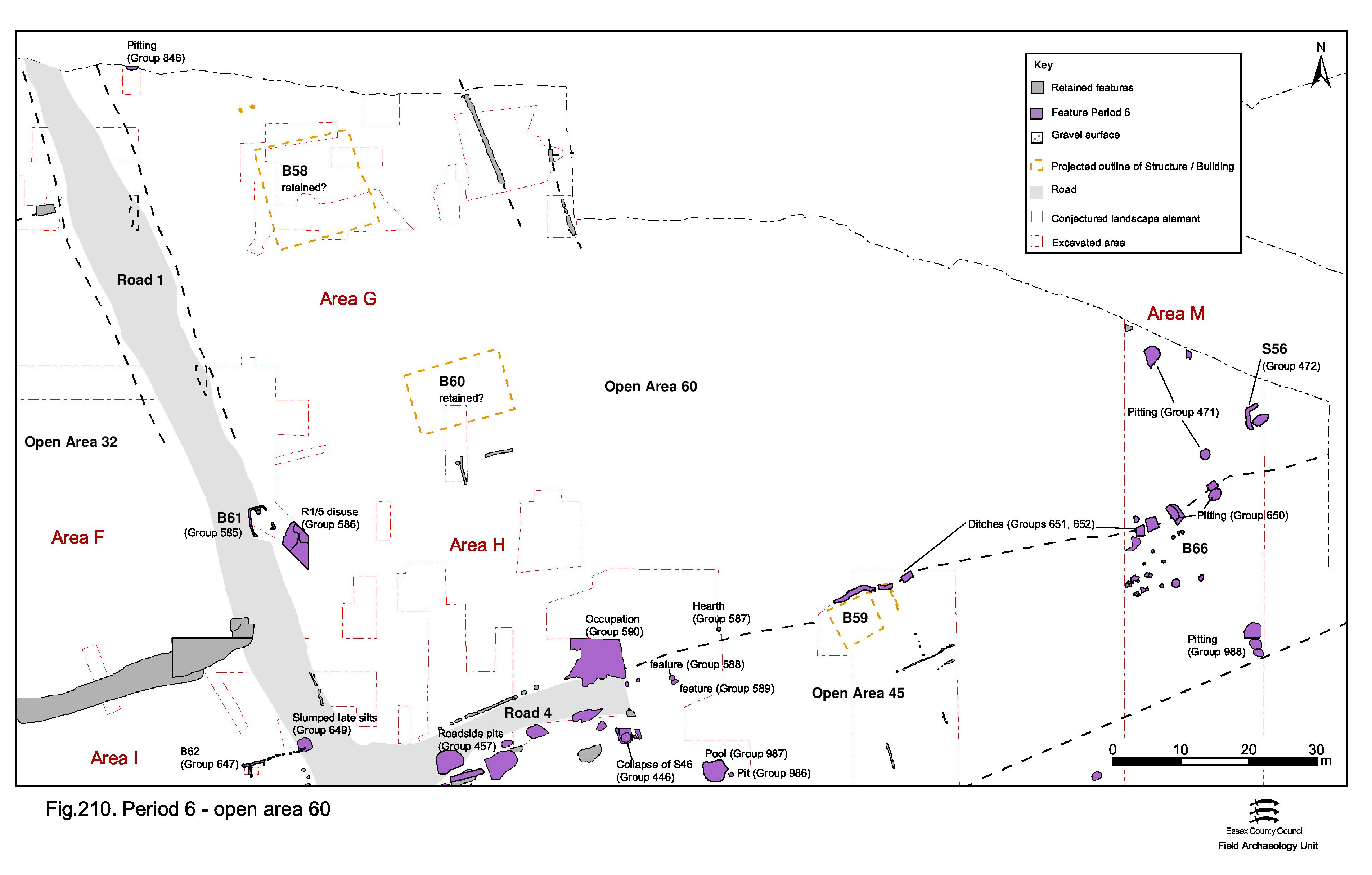
Building 58 includes a late 4th-century slot, 7083, that presumably constitutes a structural repair, and associated ditch 25111 continues to receive late 4th-century material. It is possible that Period 5 Buildings 58 and 60 continue to occupy this enlarged entity, though the lack of latest Roman activity such as pitting, except in the south of the enclosure, does not provide corroborating evidence.
Pits (Group 471) occur alongside surviving boundary ditch 25077/25078/25262. They contain large quantities of tile, pottery and metalwork. However, rather than denote particular occupation activity within OA60, they might just as easily be associated with that of Buildings 59 and 66 adjacent in OA45.
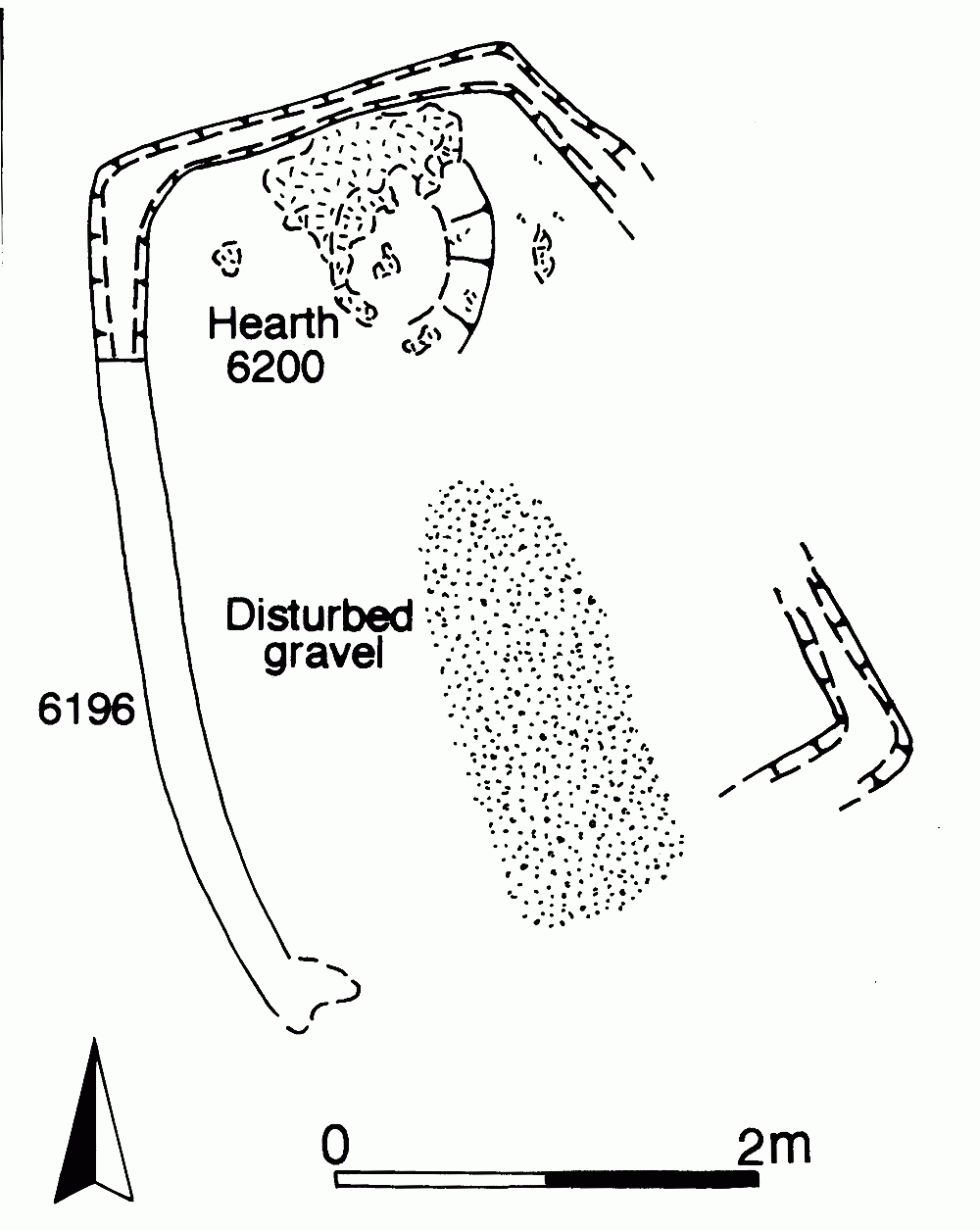
The total disregard for whatever vestiges of the Roman road network survive is clear during the 5th century, when Building 61 is constructed on the Road 1/5 junction. This small slot-built rectangular structure (Group 585) contains a hearth, but otherwise there is no indication of function (Figure 211). Its site is clearly selected because of the hardstanding provided by the surviving remnant of road surfacing, and an Early Saxon date is assumed.
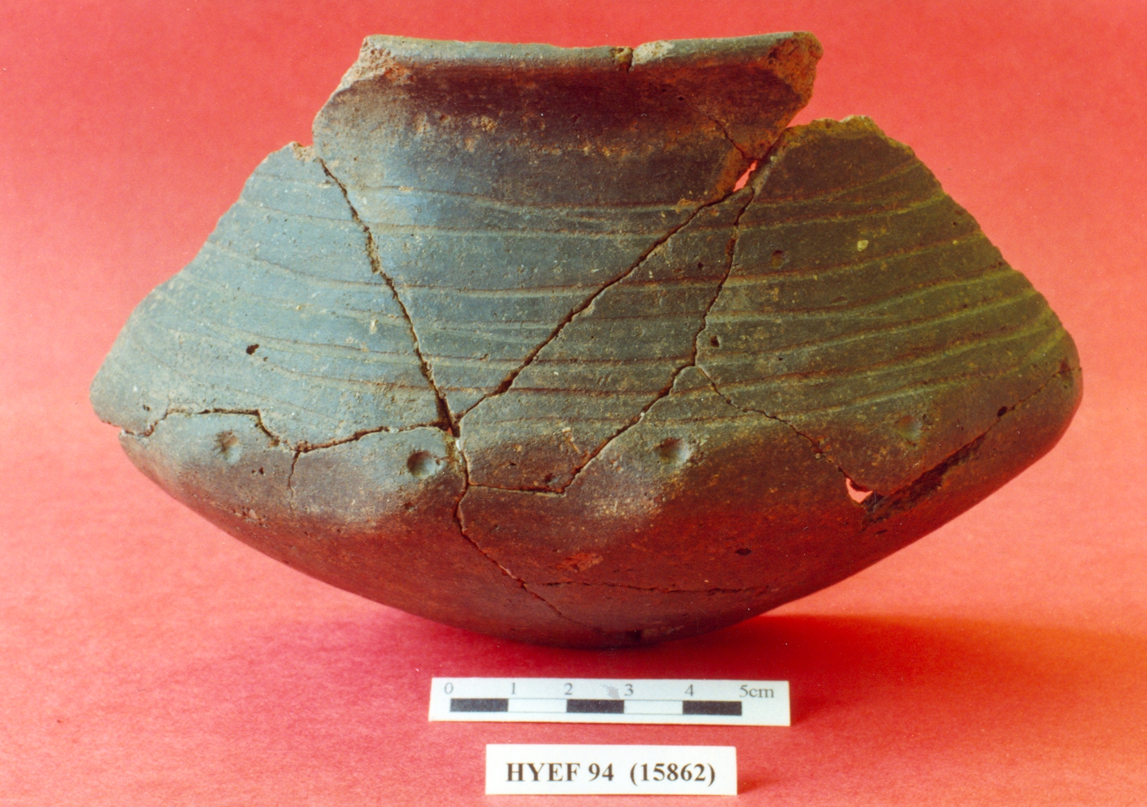
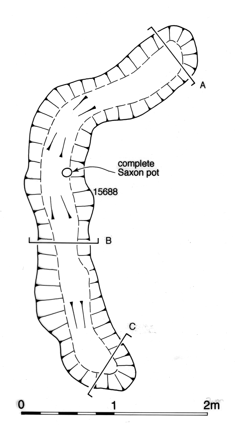
Close to the Late Roman pits in the east of OA60, an L-shaped slot 15688, the fill of which contains a complete Early Saxon ceramic vessel (Figure 212), denotes Structure 56 (Group 472) - part of a possible building foundation (Figure 213). A degree of Early Saxon occupation is therefore evident across this part of the former Roman settlement, though it is not possible to determine whether or not this utilises or disregards any vestiges of infrastructure land allotment that may (or may not) survive.
While the temple precinct and its immediate environs demonstrate continued activity up to the end of the 4th century, the contemporary situation to its west in OA18 is rather different (Figure 215). Activity within whatever survives of this enclosure is very slight and is principally limited to dumps or accumulations of silt and rubbish in the tops of earlier features (Group 649). Of particular note is the dumping of large bonded fragments of tile and opus signinum in deposits 13216 and 5768, which overlie earlier pitting.

The imposition of small four-post Structure 55 (Group 648) in its south, and Building 62 (Group 647) located alongside Road 1, does, however, hint at continued latest Roman occupation within the enclosure, though no Early Saxon features or deposits are identified. Material continues to accumulate in the late 4th century, and possibly after, in ditches 25027 and 25031 marking the northern boundary of OA18 (Groups 834, 838 Period 5), but no Saxon material is present. These ditches probably continue to represent the northern limit of the greater part of latest Roman settlement activity, though occasional features dating to Period 6 occur to their north.
As there is no indication for the survival of OA28 as a separate entity during Period 6 it is assumed it is amalgamated with OA50, which to all practical purposes now encompasses the whole of the former Southern Zone (Figure 214).
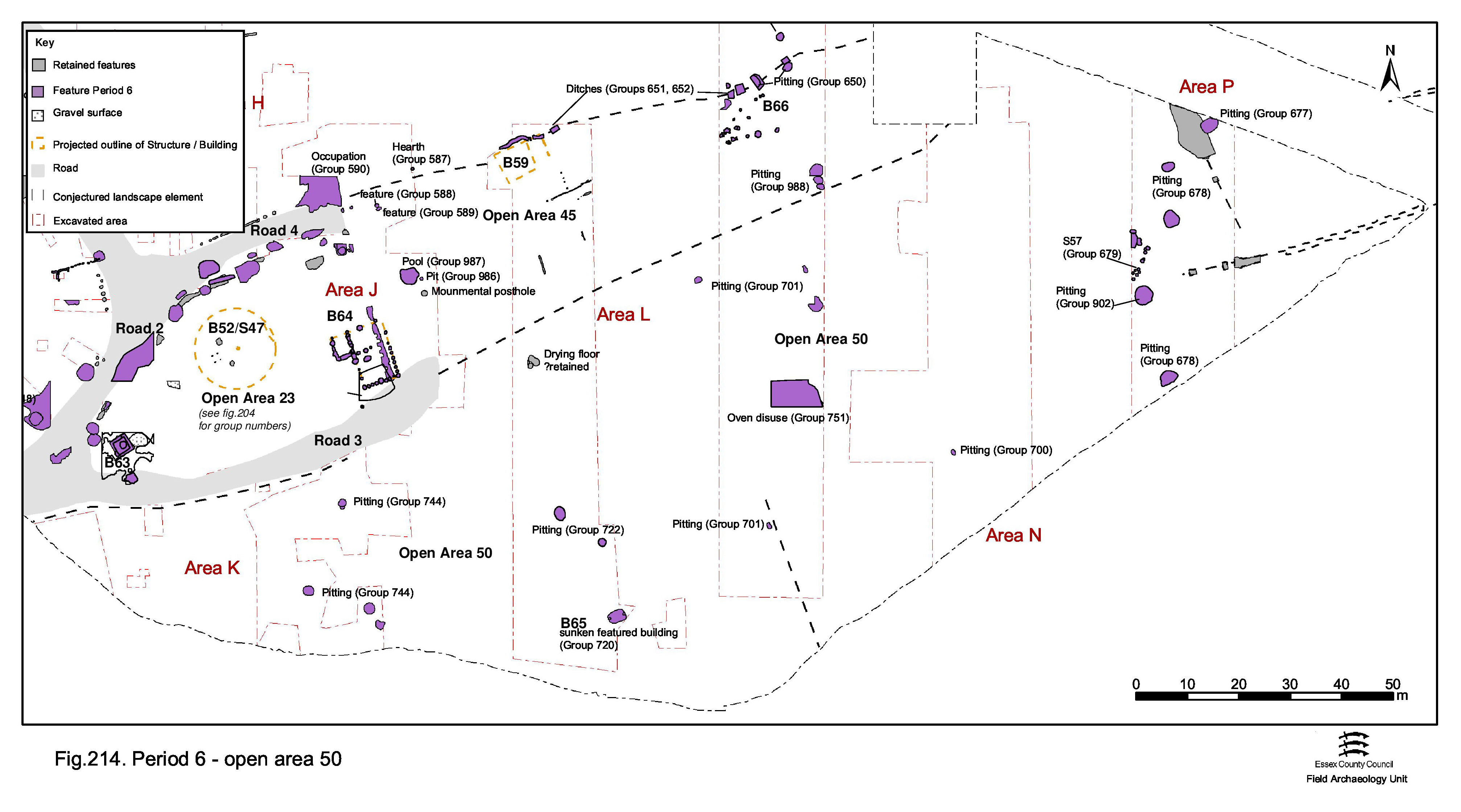
Period 5 oven/drying floor 20137 (Group 721) probably remains in use into the late 4th century and is by this time the most easterly probable crop-processing structure known. This may be a further indication of the westward contraction of the settlement and its peripheral activities.
A low density of late 4th-century pitting (Groups 677, 678, 700, 701, 744, 902) is present across the extent of OA50. All are noticeably prolific in artefacts and may reflect rubbish disposal from contemporary settlement further to the west. Particularly notable is the presence of a varied assortment of metal objects, including small personal items. However, residuality within these assemblages is high and it is therefore uncertain whether the large volume of artefacts is a genuine indication of the level of late 4th-century activity.
While the pits are generally of latest Roman date, very small quantities of Early Saxon pottery occasionally occur in some (e.g. pits 8736/8788, 11507, 15423) but may incidentally be deposited in the tops of already redundant rubbish pits. Certainly, some of the earlier pits (e.g. late 1st-century pit 15773 and Period 5 pit 20193) acquire occasional Saxon sherds in their slump hollows.
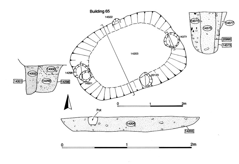
The one diagnostic Early Saxon structure, 3.3m-long sunken-featured Building 65 (Group 720) (Figures 216 and 217), is located in the south of OA50, toward the lower terrace edge. Its alignment appears to reflect the general orientation of the Roman landscape and it is perhaps likely that some vestiges of the former settlement layout are still visible when it is constructed. Although morphologically typical of an Early Saxon SFB, the pottery assemblage from its infill lacks any diagnostic Saxon pottery and instead offers a Late Roman date. However, its highly fragmented nature suggests that this is probably entirely residual and indicative of a 5th century date for the building and its demise.
While it is possible that some of the apparent latest 4th-century pits that contain the odd sherd of Early Saxon pot may be contemporary with the use of this building, only nearby pits 14529 and 14632 (Group 722) are of clearly Saxon date. The former is deliberately cut into Period 4 backfilled well 14984 and contains a 5th-century cruciform brooch (SF6238) and the largest assemblage of Saxon pottery from the site, as well as antler off-cuts (SF6121) (Figure 218) and a large residual Late Roman artefact component (KPG40).

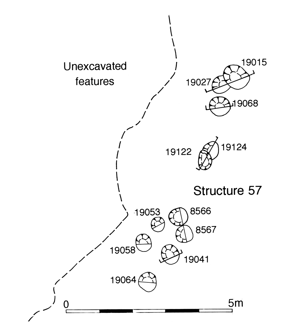
At the east end of OA50, post-hole Structure 57 (Group 679), perhaps a fenceline of Early Saxon date (Figure 219), runs amid the late pits and serves to indicate that activity of this date is as equally dispersed across the OA50 landscape as that of the latest Roman.
With that part of the Northern Zone to the east of Road 1 now being considered to be subsumed into OA60 and therefore described above, that to the west remains a distinct entity, though any subdivision of its interior is doubtful.
The nature of that part of the Northern Zone west of Road 1 is far from clear (Figure 215). Although the road may continue to provide its eastern boundary and ditch 25027 its southern boundary (see OA18, above), no subdivision of its interior is apparent. North-south ditch 25021, for so long a principal boundary within this part of the Northern Zone, seems to pass out of use prior to the late 4th century and cannot be seen to exert any further influence over this part of the settlement landscape.
As in Period 5, latest Roman features are concentrated in its northernmost investigated part. Shallow east-west gully 25240 (Group 844) is replaced by a more substantial pit/ditch 25212 (Group 845), in a fashion reminiscent of Period 3 'big ditch' 25221 in OA25. The presence of worked antler within pit/ditch 25212 suggests it could be Early Saxon in date; across the settlement, antler seems to be present in only very late assemblages (and only from seven contexts). While Period 6 features are scarce, those identified contain large and diverse artefact assemblages. Tile is abundant and strongly implies the presence of at least one substantial building or structure at Heybridge until the later 4th century. Metalwork continues to be prominent, and glass derived from items such as beads and vessels is increased. Only a single late pit is identified (pit 10504, Group 989), immediately to the west of Road 1. However, as is often the case elsewhere within the late settlement, this may just be an accumulation of late 4th-century material within the slump hollow of an earlier 4th-century pit. No overtly Early Saxon activity is apparent and is assumed to be either wholly absent or widely scattered across what remains of the Northern Zone; the focus of such occupation clearly being further north, on the opposite side of the watercourse.
Although retained here for ease of reference, the labelling of the whole of the Northern Zone east of Road 1 as OA58 is likely to be particularly simplistic by Period 6. The paucity of identifiably latest Roman activity may simply be due to the peripheral nature of the north bank location investigated. On the evidence of other excavations along Crescent Road, it is possible to assert that more concerted late 4th and 5th-century occupation is present on the upper terrace only a short distance to the north.

Although wood-lined ditch/leat 25271 probably continues to function through the late 4th and into the 5th centuries, there is no sign of concerted latest Roman activity along the north bank of the watercourse (Figure 220). Early Saxon occupation is more conspicuous, being represented by a pair of sunken-featured buildings (Figure 221), perhaps deliberately located alongside and associated with the final use of the wood-lined ditch. Building 67 (Group 973) is a 3.2m-long, relatively flimsy building, while adjacent Building 68 (Group 974) is larger and more substantial with a clay lining and apparent ramp-like extension off one corner. These structures presumably relate to the Early Saxon occupation remains previously found a short distance to the north-east on Crescent Road, where five sunken-featured buildings of early 5th century AD date were recorded (Drury and Wickenden 1982; Wickenden 1986, 17-18). Late Roman and Saxon material was also present at 39-45 Crescent Road (Roy 2003).
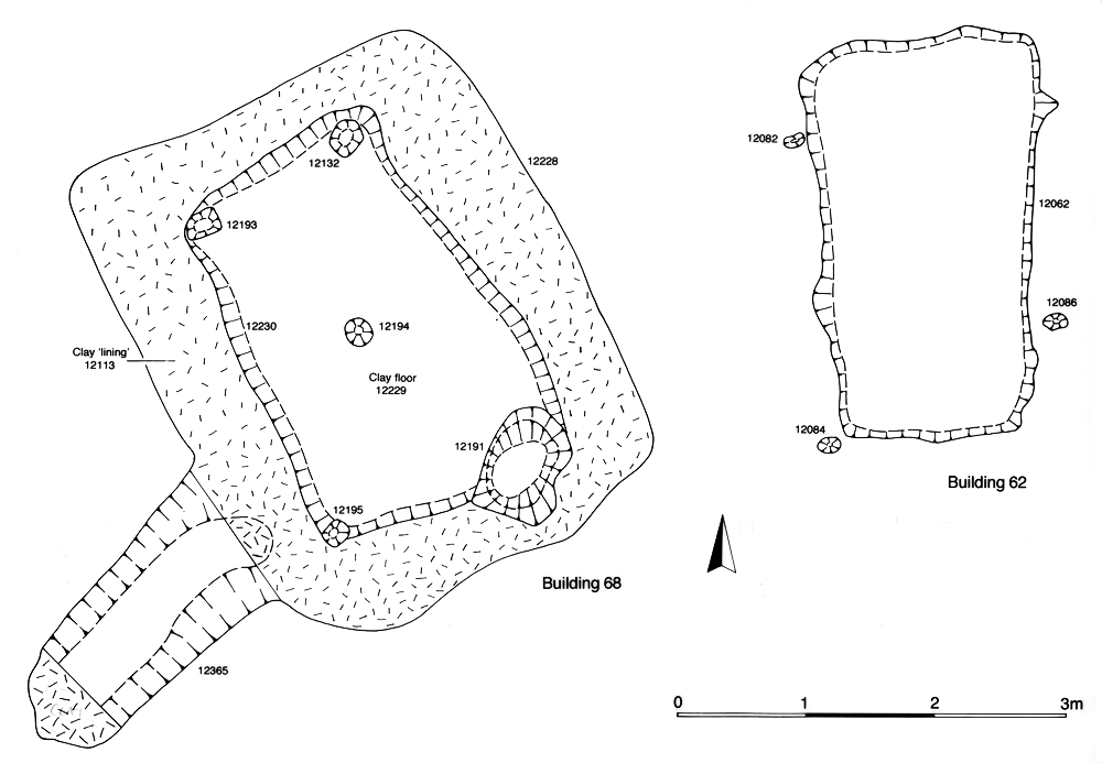
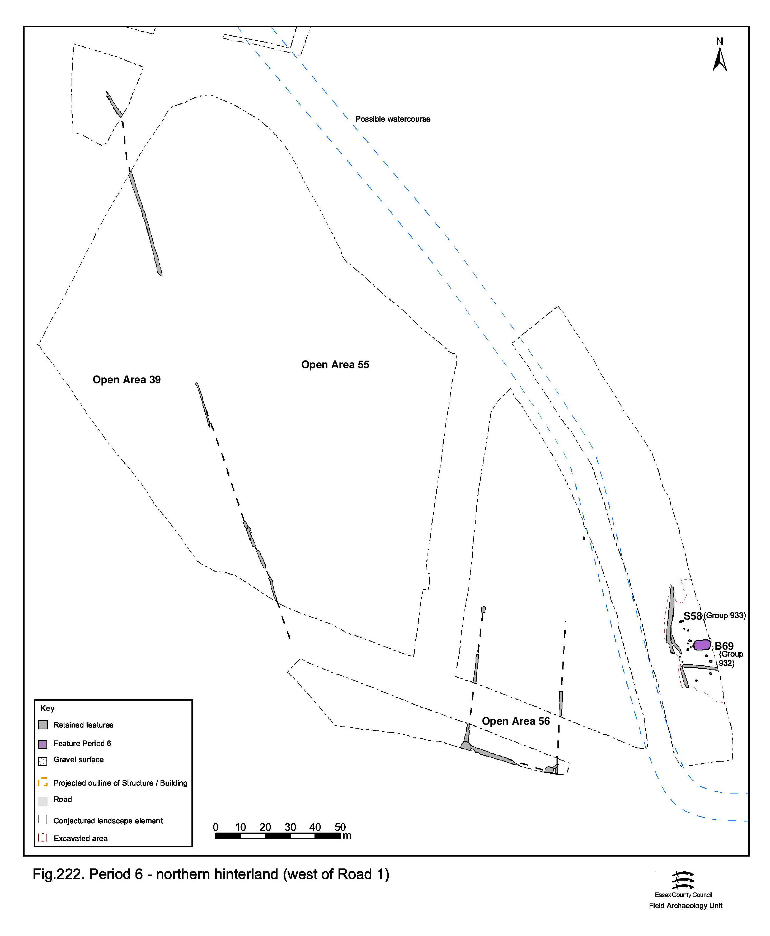
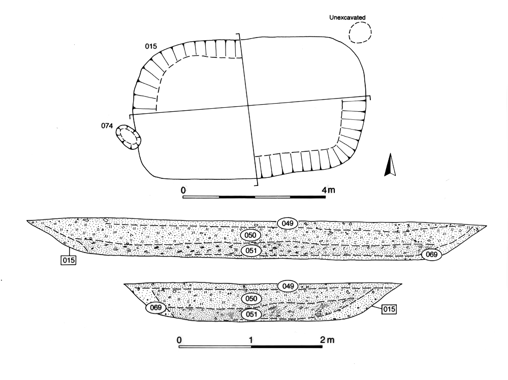
Late 4th century use of the Northern Hinterland west of Road 1 would seem to be sparse (Figure 222). As with the Northern Zone, virtually all of its enclosure system seems to have passed out of use. While some agricultural activities may be surmised to continue within the last vestiges of the Roman farming landscape on the upper gravel terrace, these have left no trace. Only that part of the hinterland east of the posited course of the watercourse can be inferred to retain some degree of structure and usage. The surviving enclosure denoted by enduring Period 4 ditches 25187 and 25189 is (re)occupied by sunken-featured Building 69 (Group 932) (Figure 223) and a number of post-holes nearby (Group 933) may constitute associated structures such as fencelines. As such, Building 69 may mark the western limit of Early Saxon occupation on the upper terrace. Containing a small quantity of Early Saxon pottery, the 6.45m-long cut is perhaps the most typical for a building of this kind investigated.
Internet Archaeology is an open access journal based in the Department of Archaeology, University of York. Except where otherwise noted, content from this work may be used under the terms of the Creative Commons Attribution 3.0 (CC BY) Unported licence, which permits unrestricted use, distribution, and reproduction in any medium, provided that attribution to the author(s), the title of the work, the Internet Archaeology journal and the relevant URL/DOI are given.
Terms and Conditions | Legal Statements | Privacy Policy | Cookies Policy | Citing Internet Archaeology
Internet Archaeology content is preserved for the long term with the Archaeology Data Service (ROR). Help sustain and support open access publication by donating to our Open Access Archaeology Fund.