Although the precise date of the abandonment of settlement at this location on the river gravel terraces is not clear, it would appear that it occurs in the Early Saxon period, when it is assumed that settlement activity shifted to the opposite side of the River Chelmer and onto the high ground where a burh was later founded in AD 916 by Edward the Elder, and now occupied by the town of Maldon. To date the earliest Saxon occupation, at a site located close to the waterfront at The Hythe, is dated to the mid-7th to mid-9th centuries AD (Ennis 2009).
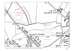
No Saxon-period occupation remains occur within the Elms Farm excavations that post-date the 5th century (Period 6). This apparent absence is substantiated by a similar lack displayed by the other investigated sites in the Crescent Road/Langford Road vicinity. However, while settlement on the gravel terraces evidently ceased, it is highly likely that this part of the landscape continued to be utilised, if only as grazing. Evidence of medieval period activity is restricted to a quantity of metalwork items, presumed to represent incidental loss or discard by individuals either crossing or actively utilising/exploiting this grassland landscape. However, continued agricultural use/management of both upper and lower terraces is more tangible in the post-medieval period, though largely restricted to simple boundary structures, land drainage and dump/levelling deposits (Figure 226).
Period 7 covers recorded land-use that post-dates the Early Saxon occupation of the investigated parts of the upper and lower gravel terraces (Figure 226). As Saxon settlement is restricted to the 5th century, this period spans the 6th to 20th centuries. In reality, the absence of medieval features narrows the focus of Period 7 to the post-medieval period.
Beyond the abandonment of the Roman and Saxon settlements, few of the previously used landscape referents have meaning. As for Period 2A, the topographical distinctions of upper and lower gravel terraces seems most appropriate in the description and discussion of the later landscape. Historic mapping provides definitive evidence of primary land division across the wider agricultural landscape, which remains essentially constant from at least the 18th century to the point of the site's development (Figure 228). The excavated evidence for post-medieval activity does, however, add some detail to the nature of land-use at this time.

During the 18th and 19th centuries that part of the lower terrace within the Elms Farm site is divided into the four fields that endure to the point of its development, although during this time their layout is disrupted first by the imposition of the Chelmer and Blackwater Navigation (constructed 1793-7) and then by the Witham and Maldon Branch of the Great Eastern Railway (constructed 1848) and its subsequent, later 19th century, improvements.
The middle field (Development Area A1-3) is divided into two by the imposition of north-south aligned fenceline Structure 59 (Group 475). While all of its substantial post-holes contain residual Roman artefacts, a number also contain post-medieval tile fragments and even in situ post stumps. These post remains survive at a greater elevation than the Roman wooden well linings, which tends to qualify this late date. A probable centrally positioned gateway is identified, which coincides with a tile dump that is interpreted as an attempt to consolidate the ground at this point. This gateway appears to coincide with the line of a footpath across the field as depicted on historic mapping, though the fenceline itself is not shown. No other features of post-settlement date were recognised on the lower terrace and it may be inferred that the fenceline served to manage the movement of grazing livestock within these pasture fields.
Although presumably entirely coincidental, it is remarkable that the fenceline ran almost on the same line as that of the temple precinct wall. While it is tempting to speculate that there may have been some indication of land-division that somehow endured the centuries, no evidence for this was recorded. Similarities between ancient and more recent alignments could be accounted for simply in terms of that dictated by the prevailing terrace topography. It is perhaps pertinent to note that this field has been called 'Stoney Field' in the more recent past, which may allude to encounters with the Roman temple precinct wall foundations or road surfaces during the cutting of some of these very post-holes.
On the eastern limit of the site (within Development Area A4), and effectively behind the post-medieval settlement of Heybridge along Langford Road, field boundary ditch 25182 (Group 952) is backfilled with rubbish-rich material in the late 19th and early 20th centuries. The disturbed nature of the land directly to its east was thought at the time of its machine-clearance to denote an infilled quarry. However, historic mapping shows it to be occupied by what appear to be a series of regular cultivation allotment plots, which may equally account for the ground disturbance and presence of 19th and 20th-century artefacts observed.
Despite being on the edge of the focus of 5th-century settlement (Period 6), this investigated part of the upper terrace within Excavation Area R bears no sign of subsequent use until the post-medieval period. Although the relict watercourse is more-or-less completely infilled by this time, the boggy and seasonally flooding nature of the whole of this northernmost field (Development Area B) presumably dictates against its use other than as pasture. Post-medieval activity is consequently restricted to a single pit or ditch (Group 975) and a dump of early 20th-century building rubble (Group 976) along the top of the defunct watercourse, the latter presumably representing consolidation and levelling of the field surface.
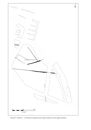
In contrast to the lower gravel terrace, the upper terrace as investigated in Excavation Area W contains a significant quantity of post-abandonment features, albeit exclusively of similarly post-medieval date (Figure 227). This presumably reflects the differing nature of agricultural use, the upper terrace most probably being arable land. The recorded remains of this cultivation activity comprises an infilled field boundary and associated drainage features (Group 934), but also a number of post-hole alignments. Post-built Structure 60 (Group 935) and adjacent fenceline Structure 61 (Group 936), both located toward the northern end of Excavation Area W, can be related to a building depicted on early 20th century mapping. Indeed most, if not all, these post-medieval features are of 19th and early 20th century date.

Internet Archaeology is an open access journal based in the Department of Archaeology, University of York. Except where otherwise noted, content from this work may be used under the terms of the Creative Commons Attribution 3.0 (CC BY) Unported licence, which permits unrestricted use, distribution, and reproduction in any medium, provided that attribution to the author(s), the title of the work, the Internet Archaeology journal and the relevant URL/DOI are given.
Terms and Conditions | Legal Statements | Privacy Policy | Cookies Policy | Citing Internet Archaeology
Internet Archaeology content is preserved for the long term with the Archaeology Data Service. Help sustain and support open access publication by donating to our Open Access Archaeology Fund.