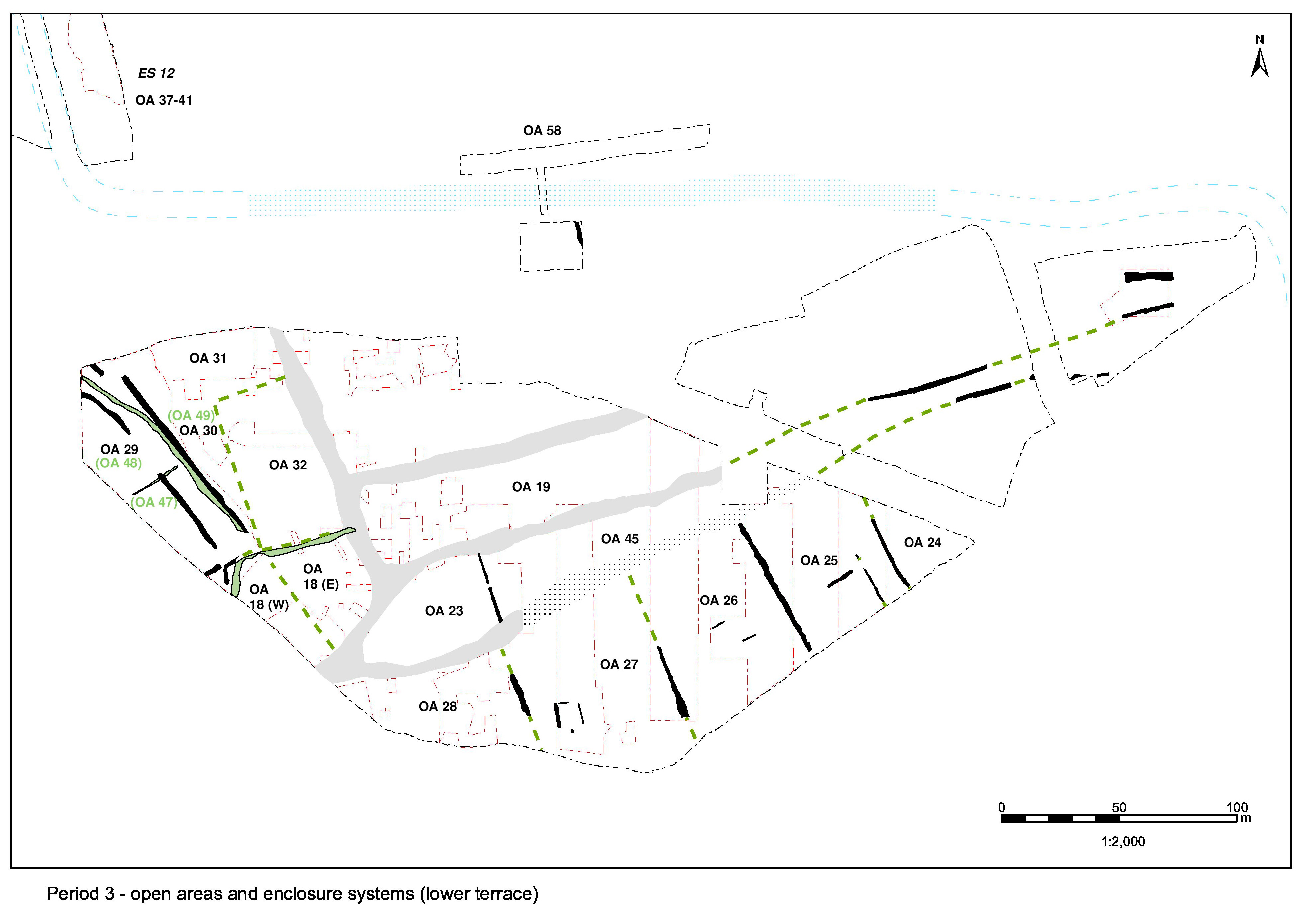
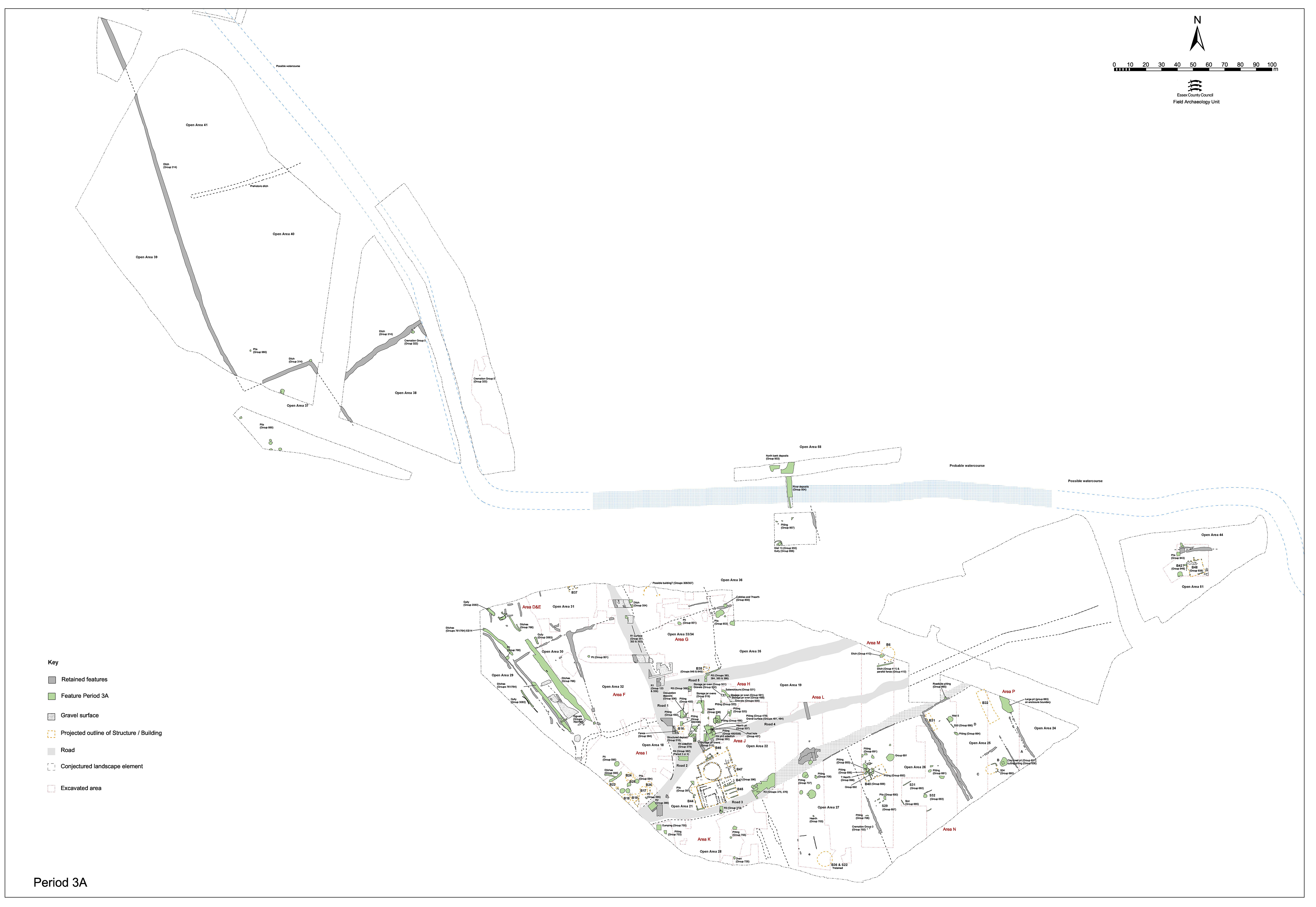
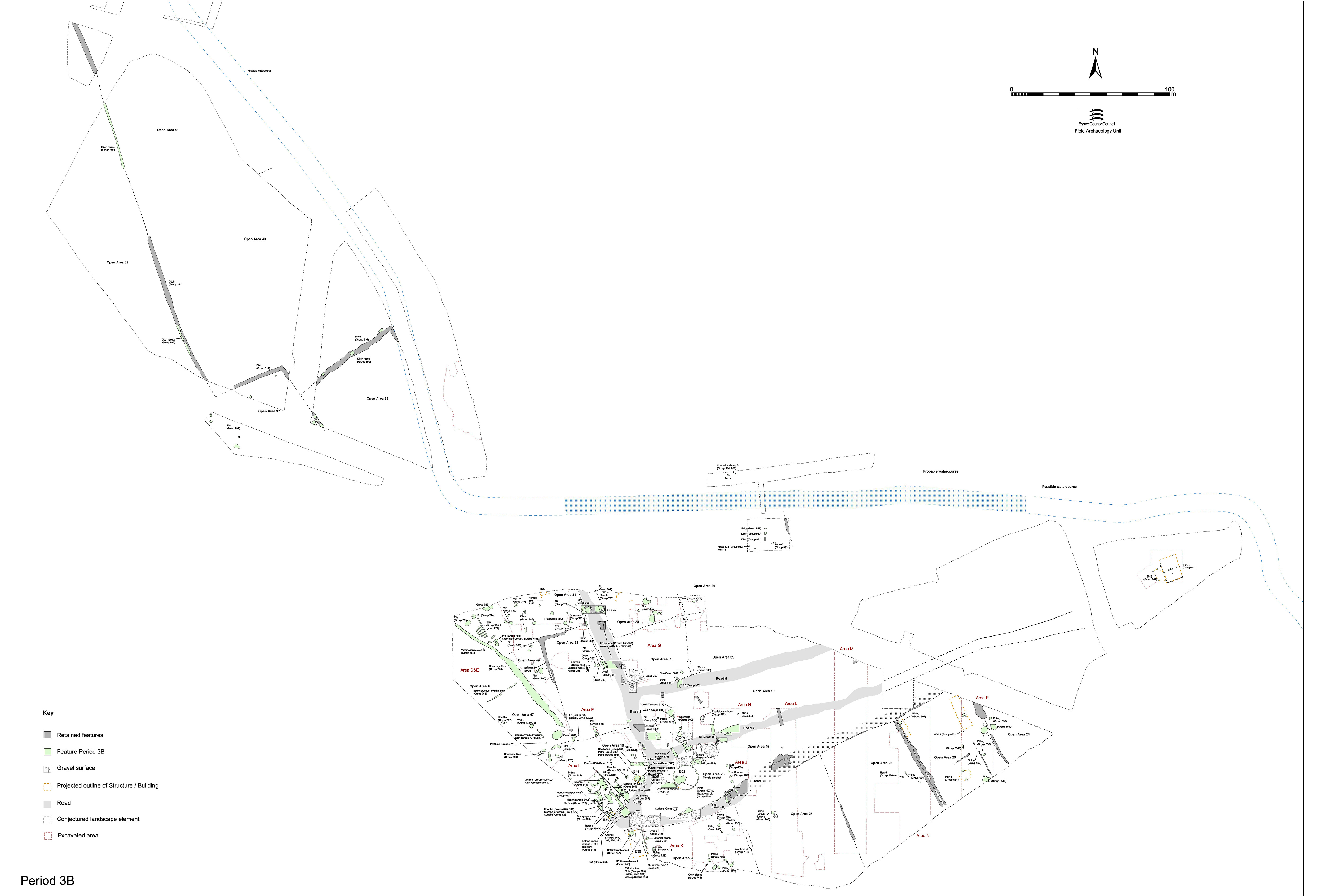
Period 3 is predominantly one of broad continuity and development following the creation of the LIA/early Roman transition period settlement infrastructure. With the essential infrastructure already laid down, there is little substantive change made to the roads or to the major enclosure systems within the various settlement zones identified (i.e. the central, northern, southern and hinterland zones). Functionally, there is generally also little change evident within the individual enclosures, excepting those of the Temple Precinct, which exhibits changing depositional practice and undergoes a second phase of remodelling in the early 2nd century, and adjacent Open Areas 18 and 19, which are conjectured to adopt a support or service role in relation to the temple precinct.
There appears to be some distinction evident between the settlement core and the peripheral activity around it. While at the centre, Roads 1 and 2 are periodically resurfaced, the 'side' Roads 3, 4 and 5 are only actively maintained at their western ends and rapidly become tracks beyond the settlement core. The point at which they degenerate may be used to infer this boundary. It is notable that this broadly coincides with the frontage of the precinct as formalised in Period 2B.
The area between Roads/tracks 3-5 remain open throughout the early Roman period as a clear, metalled-surfaced, space in front of the temple (OA21) and the adjacent enclosure (OA19), with few early Roman features being permitted to encroach upon it. Indeed, it may be argued that the clearance of some Period 2B buildings on the peripheries of the central zone (e.g. Building 6 in the north of Excavation Area M, eastern hinterland Building 48 and Building 15 in the south-west corner of the northern zone) by or during early Period 3 (pre-2nd century) may emphasise the active preservation and enhancement of this openness. In particular, the site of cleared Building 6 is subsequently resurfaced, perhaps in association with the remodelling of the religious focus.
The regular strip enclosures of the Southern Zone endure, although their boundary ditches become infilled and presumably defunct by or during the start of Period 3. It is presumed that these boundaries are perpetuated, perhaps being demarcated by hedges or fences instead. Reduced numbers of pits within its enclosures suggest some differing/changing disposal practice and/or land-use. Buildings are concentrated along the Road 3 frontage with the rear of the plots generally subdivided - presumably into gardens and/or animal pens.
Peripheral areas of the settlement experience a degree of change too. While the system of in-fields and routeways of the Northern Zone are modified west of Road 1, the north bank of the watercourse is seemingly reclaimed and built up, after which at least part of it becomes the location of cemetery activity. The nature and location of mortuary practice in other parts of the Northern Hinterland Zone can also be seen to change, though its primary agricultural function remains constant.
Sub-phases of activity, identified as 3A and 3B, are discernible in OA18 and OA21/22, across western parts of the northern zone and north bank of the Northern Hinterland. Although perhaps simplistic, these sub-phases broadly approximate to the later 1st (3A) and early 2nd to mid-2nd centuries (3B) respectively. Those features that appear to span both sub-phases are ascribed a broad Period 3 date range (later 1st to mid-2nd century) and appear on both plans. Of all periods, Period 3 is the most complex in terms of sub-phasing as demonstrated by the major stratigraphic relationships/sequences exhibited by its component remains. However, this is extremely difficult to apply satisfactorily and uniformly on a site-wide basis. As might be expected, the type, scale, speed and nature change as manifest in the archaeological record differs across the various parts of this large and dynamic settlement site. Although the road infrastructure provides a framework for the site, it also subdivides and separates the zones and their component land entities from one another; few 'change horizons' can be tracked across these boundaries, or across the relatively wide extents of their interiors, with any great confidence. The contemporary nature of any change, in the majority of cases, can therefore only be suggested and argued. Given that each of the zones, and many of the enclosures within them, can be demonstrated to possess their own functional character, this lack of uniformity of development and change is not unexpected, but remains problematic.
Comparing development and change within and between adjacent enclosures/Open Areas (OAs) is particularly problematic. The lack of stratigraphic relationships across much of the site and the variable reliability and accuracy of available feature/deposit dating has implications for the accuracy of Period 3 sub-phasing and its coherent presentation. Pitting, one of the primary aspects of land-use activity within many areas of the settlement (especially the Southern Zone enclosures) is very difficult to satisfactorily sub-phase. Carried out primarily on the basis of the ceramic dating of their fills, allocation to a specific sub-phase is often somewhat arbitrary and further compromised/confused by the inability to date a significant number to no better than 'broad Period 3'. It must also be appreciated that a further quantity of early Roman pits can be assumed to remain essentially unphased where only a general 'Roman' date can be assigned. Association with, and understanding of, the relationship of pits to buildings, changing boundaries, etc., is therefore difficult.
Note: Period 3c was identified during the initial spot-dating but subsequently was subsumed into the later stages of Period 3b.
By and large, the settlement layout of roads and enclosure systems imposed in Period 2B is retained into, and indeed throughout, Period 3 (Figure 69, Figure 70, Figure 71 and Figure 72). As such, there is often little need for further description of these beyond comment on their maintenance and/or modification - the major exception being that part of the Northern Zone west of Road 1, where numerous adjustments to boundaries and a relatively clear stratigraphic sequence demonstrates a greater complexity of change and development that requires commensurate description and discussion. Elsewhere, change is largely manifest in the creation, use, disuse and clearance/infill of remains representing structures and activities within individual land-use entities; the temple complex being a prime example of this in Period 3.
Following its imposition in Period 2B, maintenance of the road infrastructure during Period 3 is not wholesale, but evidently concentrates upon that part of the system serving the settlement core and perhaps the principal through-route as represented by Roads 1 and 2. In general, two episodes of concerted resurfacing are evident, though these are by no means comprehensive along the exposed length of each road. In reality, some of these may amount to little more than a whole series of localised repairs, enhancements and replacements. The precise status and nature of 'side' Roads 3, 4 and 5, as they extend out of the perceived settlement core, is ambiguous. It is tempting to associate these resurfacing episodes with some of the wider developments and changes identified within the Central Zone enclosures alongside.
As a major route through the settlement, Road 1 is actively maintained during the late 1st to mid-2nd centuries AD, displaying two distinct episodes of resurfacing where investigated toward its northern recorded extent, in Excavation Area F. The first resurfacing seals silty-sand layers (Group 351), which are interpreted as likely use-accumulation upon the earlier road surface. Bonded gravel surfaces (Groups 352 and 353) overlie and incorporate parts of the Period 2B road deposits, while also extending out to overlie the fills of the original Period 2B roadside ditch, so forming a cambered and well-bonded thoroughfare now some 8m wide. This enlargement/shift necessitates the creation of new roadside ditch 25246 (Group 354) along its east side, which extends down to the Road 1/5 junction. A ditch (Group 360) is also added to the western side of Road 1 at this time - although it is conceded that this, and its subsequent re-cutting, could perhaps remove all trace of a Period 2B predecessor. Its full southward extent is not established, but it certainly does not reach as far as OA18.
To the south of its junction with Road 5 (i.e. through Excavation Areas H and I) there is no further evidence of this first early Roman resurfacing episode for Road 1, though it would seem that the Period 2B surface remains in active use as it continues to subside into underlying earlier features (e.g. waterhole/pit 6734). Early Roman silts accumulate in the resultant hollows (Group 363). Suggestions of apparent rutting are observed in these silts, bounded by a probable fenceline, or even minor revetment (Group 364).
The second Period 3 resurfacing of Road 1 is preceded by clean clay/sand bedding layers (Group 355) that level out the camber, and by the infilling of wear and subsidence hollows (Group 357). At the northern end of the road the overlying resurfacing comprises patchy gravel deposits (Group 356) that incorporate the surviving, highest, central part of the previous road surface. This levelling and extension of the pre-existing road deposits may result in the road widening to as much as 11m in places, although already encroaching roadside accumulations could perhaps limit this to the more usual 8m seen elsewhere.
Further south, this second Period 3 resurfacing episode is more concerted - comprising a 0.13m thick, compact and bonded gravel layer some 5.6m wide (Groups 358, 359) which, in the vicinity of the Road 1/5 junction, is observed to merge with the interior surfacing of OA33. While the eastern roadside ditch has seemingly passed out of use and is overlain by this resurfacing, the western side ditch 25244 continues to be maintained, as denoted by its re-cutting 25245 (Group 361), into the 2nd century.
The first Period 3 resurfacing of Road 2 probably occurs in the second half of the 1st century (Groups 365, 366, 382). At its south-west exposed end, the road incorporates the earlier surviving Period 2B surface (Groups 370, 371). Lacking roadside ditches, the 8-11m wide cambered surface tends to merge with surfacing across the interior of adjacent OA18. Its worn surface is overlain by early 2nd century gravelly silt material that accumulates through its use. A second Period 3 resurfacing episode (Group 367) could be early Roman (early 2nd century?), but could equally be as late as mid-3rd century, bedded on gravel and sand make-ups that encroach upon the OA18 interior. Further accumulated silts overlie this phase of road surface (Group 368).
Active maintenance of Road 3 seems to be restricted to its western end, at its junction with Road 2 and alongside the temple precinct (OA 21/22, then OA23). Three resurfacing episodes can be discerned, though the latest may only constitute localised repair. While the lowest is rather worn or degraded (Groups 372, 375, 377) its replacement (Group 373) is more substantial at some 0.1m thick, with signs of rutting on its surface. Both the road surface and an accumulated fill in a subsidence hollow contained 2nd century material. The third surface (Group 373) may denote ongoing repair, rather than concerted resurfacing, throughout Period 3 and possibly beyond. Like Road 2, Road 3 does not appear to be delineated by ditches on either side. Road-wash deposits (Groups 376, 378) along the roadside suggest continuing use of these surfaces into the Late Roman period (Period 5), perhaps with little or no maintenance. It is notable that Period 3 surfacing is not traced eastward much beyond the frontage of the temple complex, itself very probably denoting the limit of the settlement core. So, it seems that Road 3 is not actively maintained beyond the centre of the settlement and is allowed to degenerate into little more than an unsurfaced track. However, Road/track 3 clearly continues in use, contemporary occupation and pit digging alongside in the Southern Zone generally not encroaching upon its line. However, a few pits (e.g. 11347 and 11731 in Group 665 and 20187 in Group 707) are noted to 'overspill' from adjacent enclosures OA25 and OA27, suggesting that the line of track 3 is not entirely respected.
It is clear that this thoroughfare continues to function into Period 3 as indicated by maintenance and replacement of a flanking ditch (25254/25256 replacing 25255) along the northern edge at the western end of the road (Groups 379, 380), though no contemporary resurfacings are identified. Probably in the mid-2nd century, after the roadside ditch is infilled, a new 0.07m-thick gravel surface is laid over levelling and bedding layers (Group 381). Between 5.5-8m wide, its surface bears evidence of wear, rutting and repair. It is speculated that this resurfacing episode is contemporary with the construction of the second temple precinct wall - the inclusion of rag-stone fragments being common to both. Like Road 3, the eastern part of Road 4 rapidly degenerates to an unsurfaced track and is not marked by flanking ditches in this period.
Following an episode of silt accumulation (Group 383) a compact gravel layer (Group 384) is laid over. A second and more expansive early Roman surface is laid on top, constructed on sandy and silty clay bedding deposits (Groups 385, 386). This 0.1m-thick road surface appears to be cambered. A third gravel surface (Group 387), laid directly on top of the preceding surfaces without any discernible bedding layers, is probably also Period 3, but elements of it could perhaps be laid as late as Period 4. This early Roman road is flanked by shallow and wide gully 25248 along its northern edge (Group 389), which is subsequently replaced by a fence-line (Group 390). Although the exposed eastern extents of the road are not investigated, a gully/ditch seemingly extends along much of its length, at least within Areas A1-A2. Ditch fragment 25263 in Excavation Area M may be part of this.
The development of the temple complex in OA 21/22/23 is judged to be central to development and change within the investigated part of the Central Zone during Period 3. Adjacent Open Areas 18 and 19 are perceived to become increasingly associated with the functioning of the religious focus, being remodelled and perhaps taking on support roles that include looking after the needs of temple visitors. The growing complexity and then redevelopment of the temple area presumably reflects its importance, success and wealth, as does the expansion of its influence over other parts of the settlement. The perpetuation and likely expansion of surrounding open areas to accommodate increased numbers of temple visitors is a further expression of this success. The implications of Period 3 temple complex development, change and expansion to the understanding of religious practice within the settlement is explored elsewhere (Vol. 1, Chapter 6).
The land units defined and bounded by the imposition of Roads 2, 3 and 4 in Period 2B persist into the early Roman period proper (Figure 73). Period 3 sees broad continuity of their religious function with the temple complex, occupying OA21, growing in the late 1st century (Period 3A) and then undergoing significant structural and depositional change in the early to mid-2nd century (Period 3B).
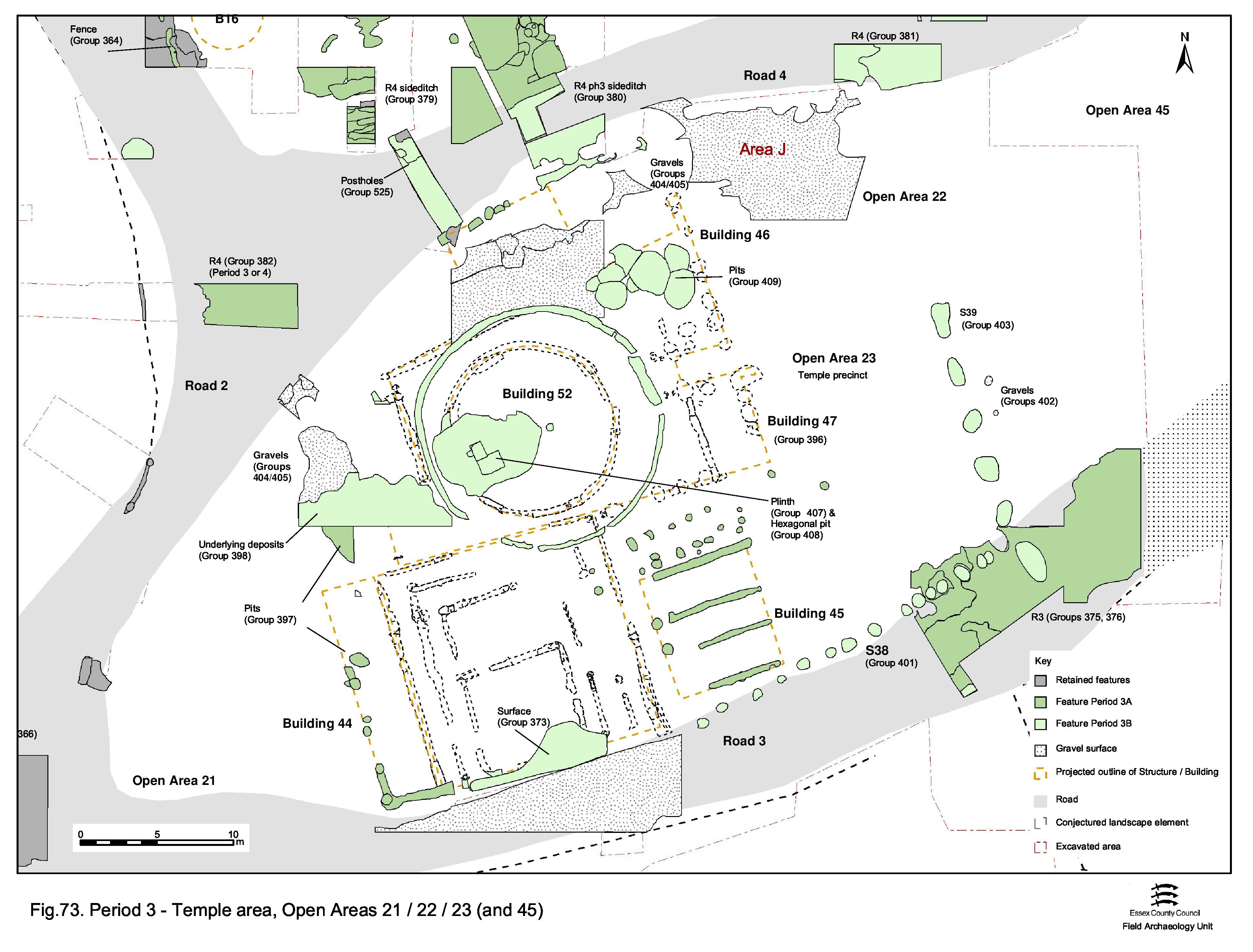
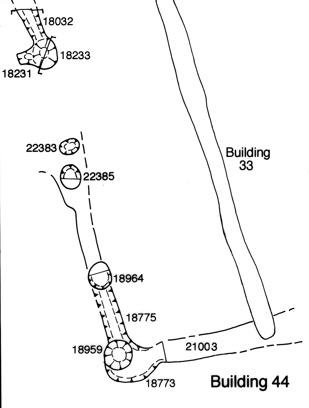
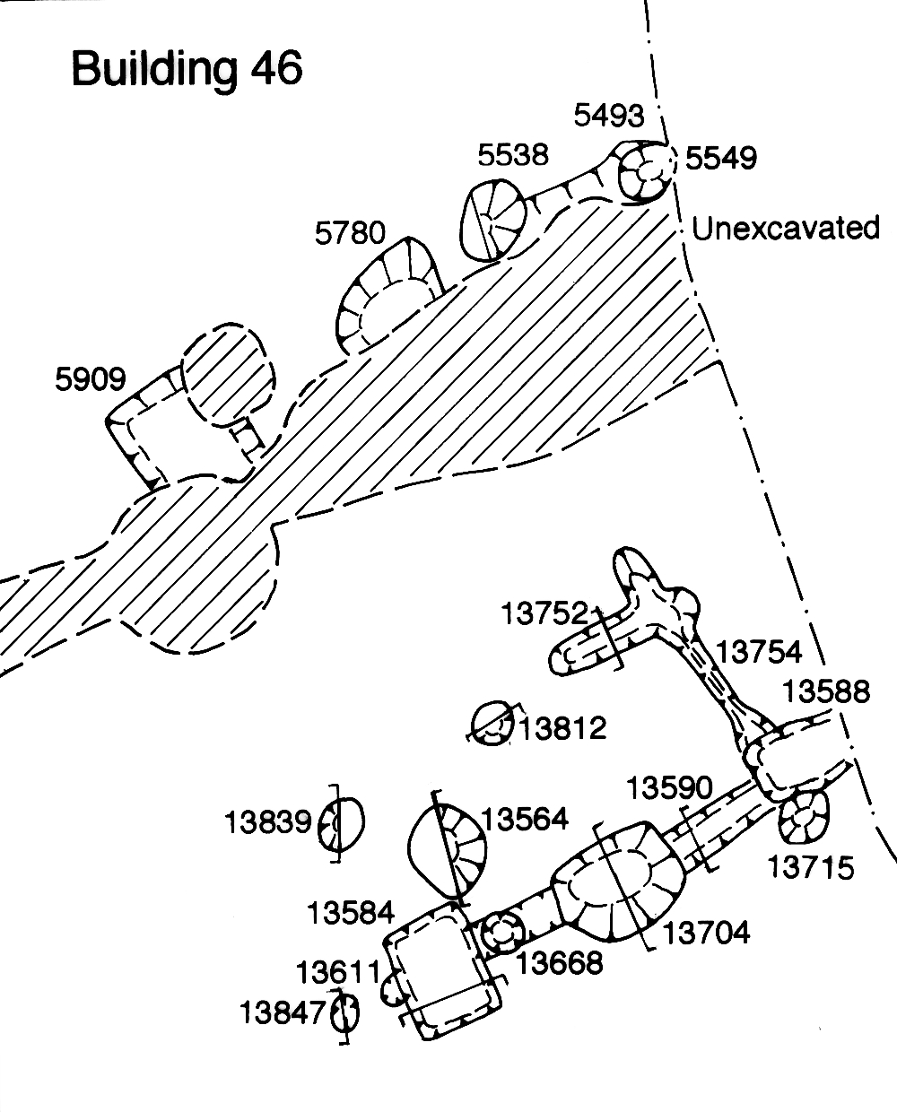
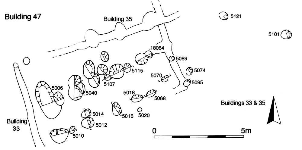
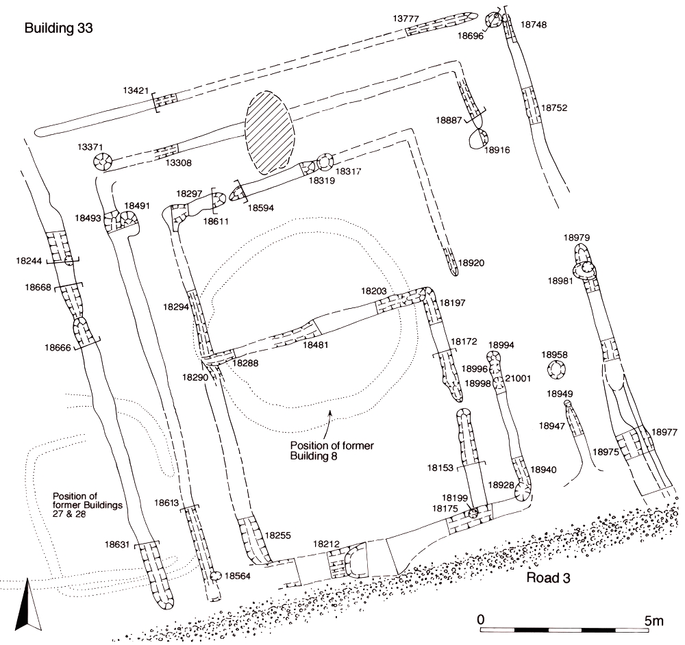
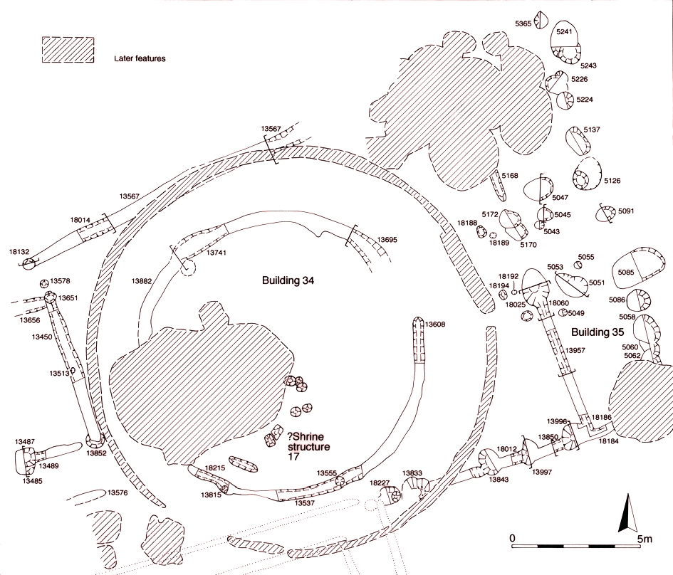
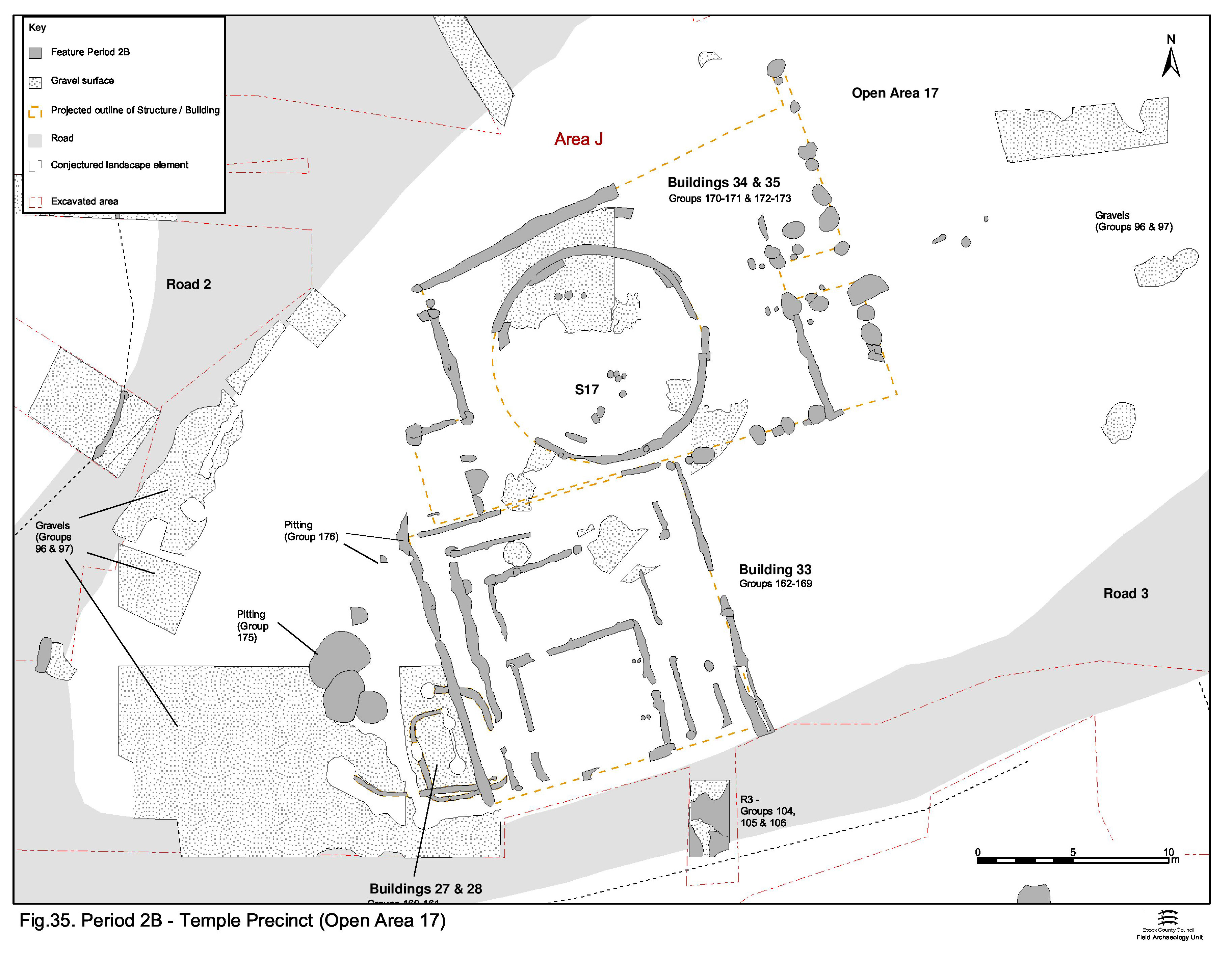
The circular temple, in its trapezoid enclosure (Buildings 34 and 35) together with square Building 33, all established in Period 2B, continue as the principal elements of this complex (Figure 33, Figure 34 and Figure 35). A number of minor structures, Building 44, 45, 46 and 47 (Groups 391-396), presumed to be of an ancillary nature, are added on three sides of the existing building complex during the second half of the 1st century AD (Figure 69). Notably, none are added along its eastern frontage. These additions are, in reality, a further part of the same episode of development following initial remodelling of the LPRIA religious focus, the only difference being that recognisably Romanised material is now being deposited.
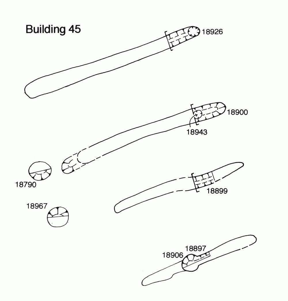
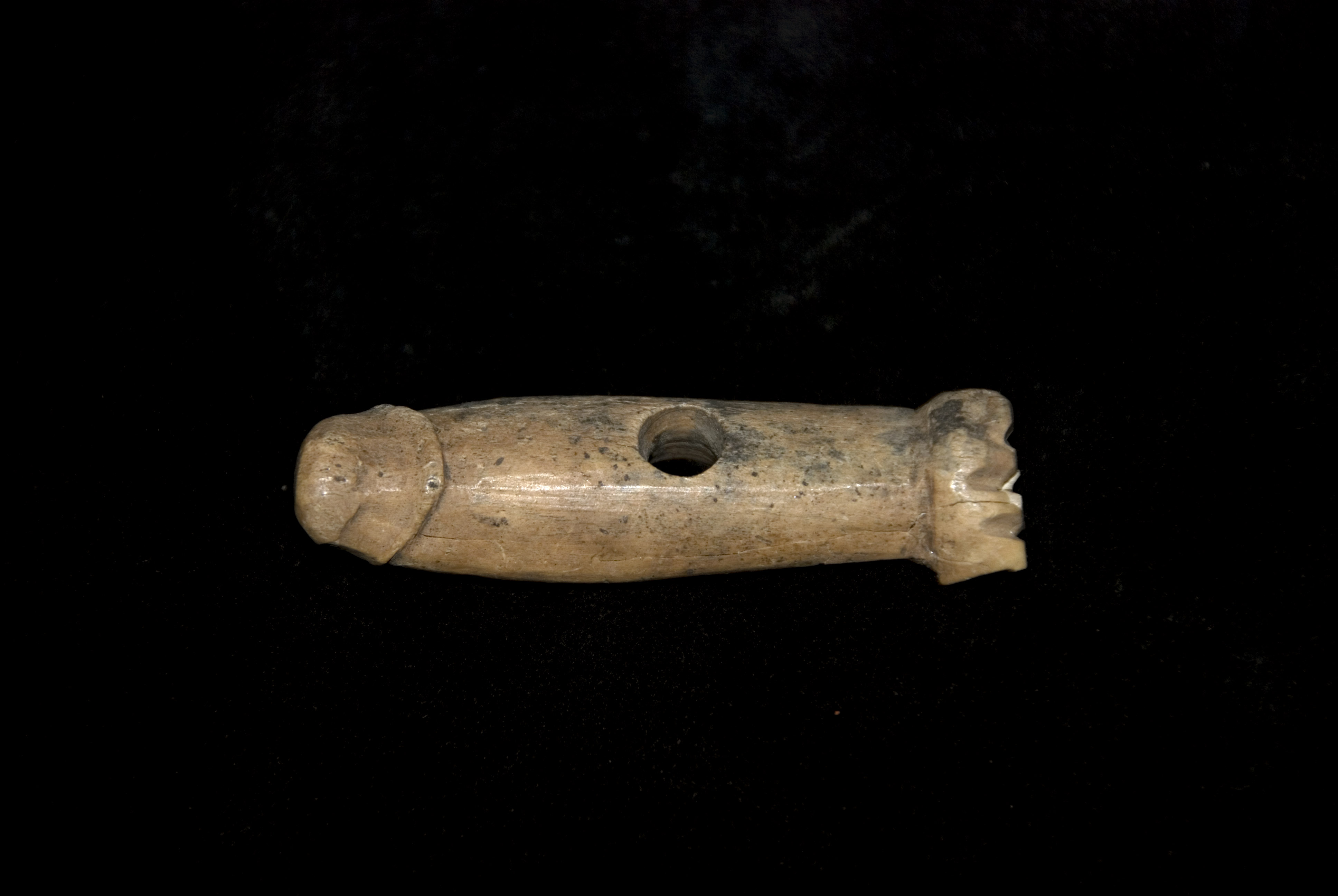
Buildings 44, 45, 46 and 47 (Figures 74, 75, 76, 77) are postulated to perhaps function as priests' quarters, store rooms or even shops, and may serve to show that the religious centre prospers at this time. Although depositional activity continues to be restricted to the rear of the temple buildings, it seemingly becomes focused upon single large pit 13892 (Group 397). Among more mundane material, this pit contains a bone 'fist-and-phallus' amulet (SF4742).
It appears that the precinct perimeter is still not formally marked during this period - at least not until Period 3B at the very earliest - although it is possible that such Period 4 and 5 features subsequently remove any trace of earlier boundary markers. That part of OA21 to the east of the temple complex buildings is evidently kept clear of intruding pits and occupying structures and is presumed to continue to function as a surfaced open space.
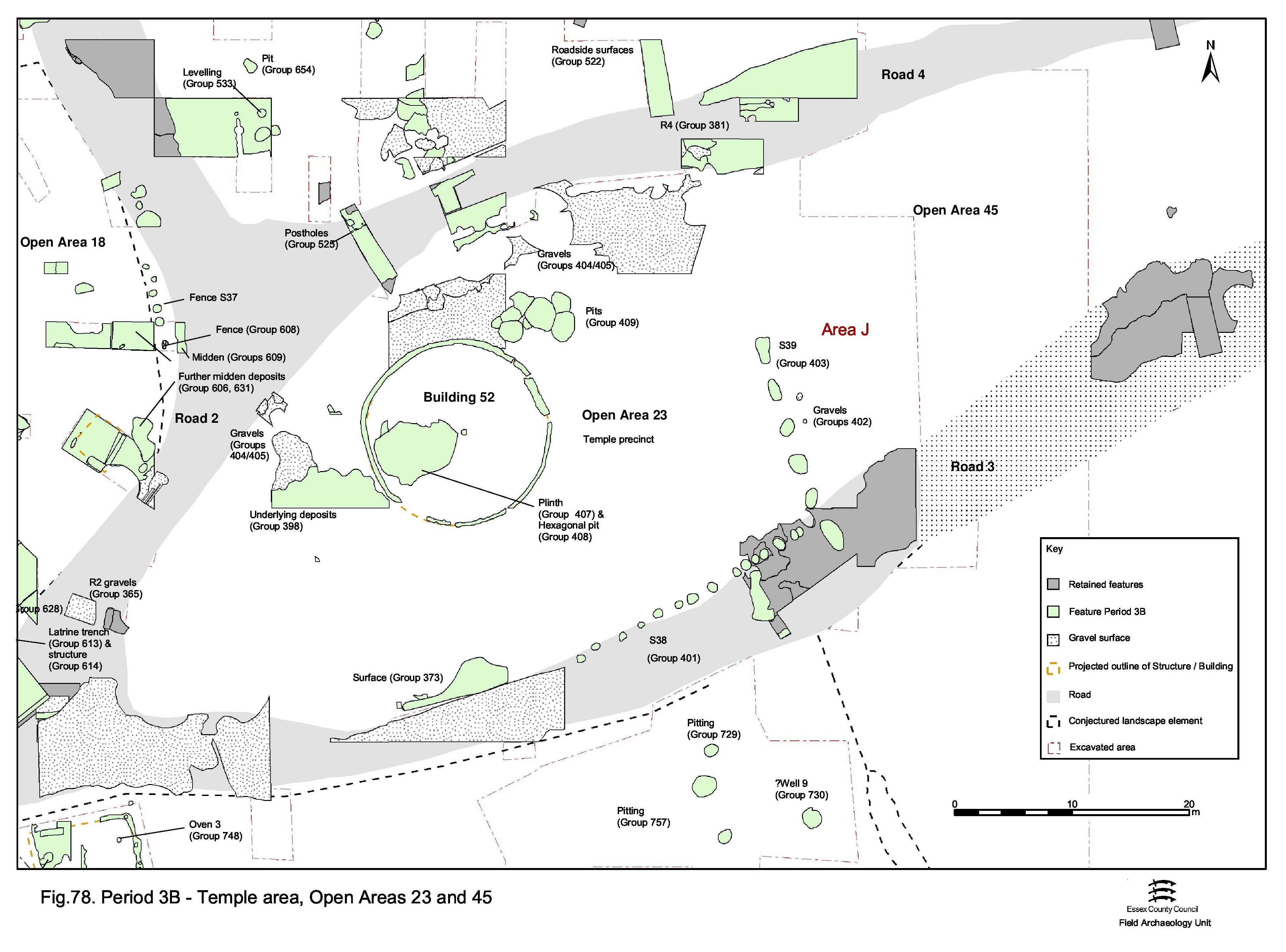
The expanded complex does not endure long, being remodelled in the earlier 2nd century (Figure 70). Buildings 34, 46 and 47 are clearly demolished, presumably along with all the other standing structures, seemingly as a single act, and replaced with a single, larger circular temple (Building 52, Group 406) which dominates what is now becoming a recognisable precinct or temenos (Figures 78-79). By this time, the precinct boundaries are formally defined along the sides of Roads 2, 3 and 4, by fences (S38, Group 401), and perhaps in places by shallow ditches. The eastern 'front' of the precinct is marked by a substantial wooden screening fence or wall (Structure 39, Group 403) that for the first time makes the temple precinct a fully enclosed entity.
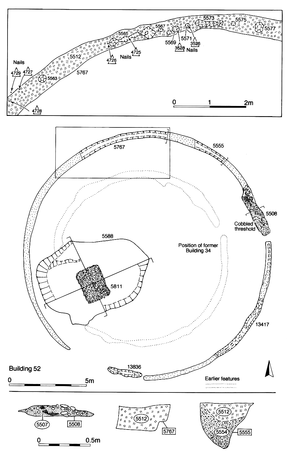
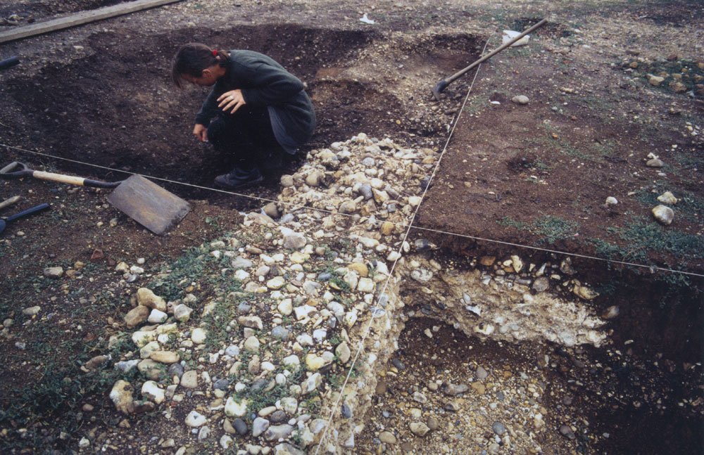
Although this episode brings about a very marked change to the religious focus, the degree of underlying continuity embodied in these changes should not be overlooked. Most obviously, the new temple is constructed directly over and with seeming reference to the site of the earlier structure (i.e. Building 47), their wall foundations being almost concentric to one another and their doorways identically aligned. Within the new temple a sequence of activity centring upon the insertion of a masonry shrine or altar plinth 5811 (Group 407) (Figure 80) clearly shows that structural development continues but is now largely confined to the augmentation of the temple itself. At some later date (but within the same phase) a near-hexagonal pit 5588/13432 (Group 408) is excavated around the plinth, leaving it standing on a low pedestal of natural gravel. It is unclear whether this was dug in order to reduce the width of the plinth. The pit is apparently quickly and deliberately backfilled; the main finds component is septaria rubble and mortar, which is presumed to derive from the plinth itself, as well as some chicken bones. Given that pits outside the temple doorway also contain chicken bones, it seems that there is a ritual aspect to the deposition in this pit - as might be expected for such a conspicuous feature inside a temple.
Outside the circular temple, the precinct (now OA23) is resurfaced (Group 405), as perhaps are flanking Roads 3 and 4 (Groups 373, 381). Gravel surfacing extends eastward (Group 402), beyond the confines of the precinct, and the associated importance of the open space (now OA45) between Roads 3 and 4, in relation to the temple, is noted. Within the precinct, surfaces east (in front) of the temple seem to have been kept particularly clean during this period, as might perhaps be expected.
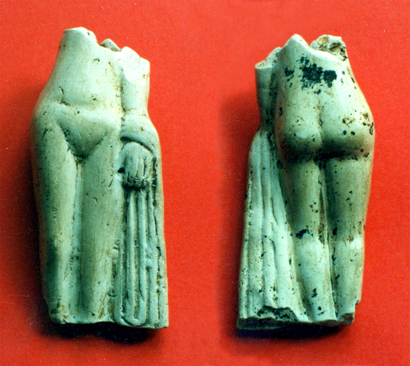
The change between Periods 3A and 3B is not restricted to the temple structures; depositional activity within the precinct also seems to alter, both in terms of location and perhaps function. By the early 2nd century, the pitting to the rear of the temple ceases and the area accumulates sandy silts on its gravel surface (Group 398). Pitting, is now located in a tight, inter-cut cluster in front of the temple, immediately to one side of its entrance, rather than to its rear as had previously been the case (Group 409). Although not particularly obvious, their artefactual contents suggest an element of ritual deposition in these pits and include chicken bones and a pipeclay Venus figurine (SF4717) (Figure 81).
OA45, now distinctly separate from the temple precinct owing to the imposition of Structure 39, is notable for its conspicuous lack of Period 3 remains. The emptiness of this surfaced expanse directly in front of the religious complex is probably deliberate, the open area presumably functioning as a formal public space - perhaps for the congregation of pilgrims/worshippers participating in temple ceremonies/rituals or else other associated activities of religious festivals.
OA18 clearly undergoes very significant change during Period 3, with a clear horizon evident between early and later episodes of early Roman use.
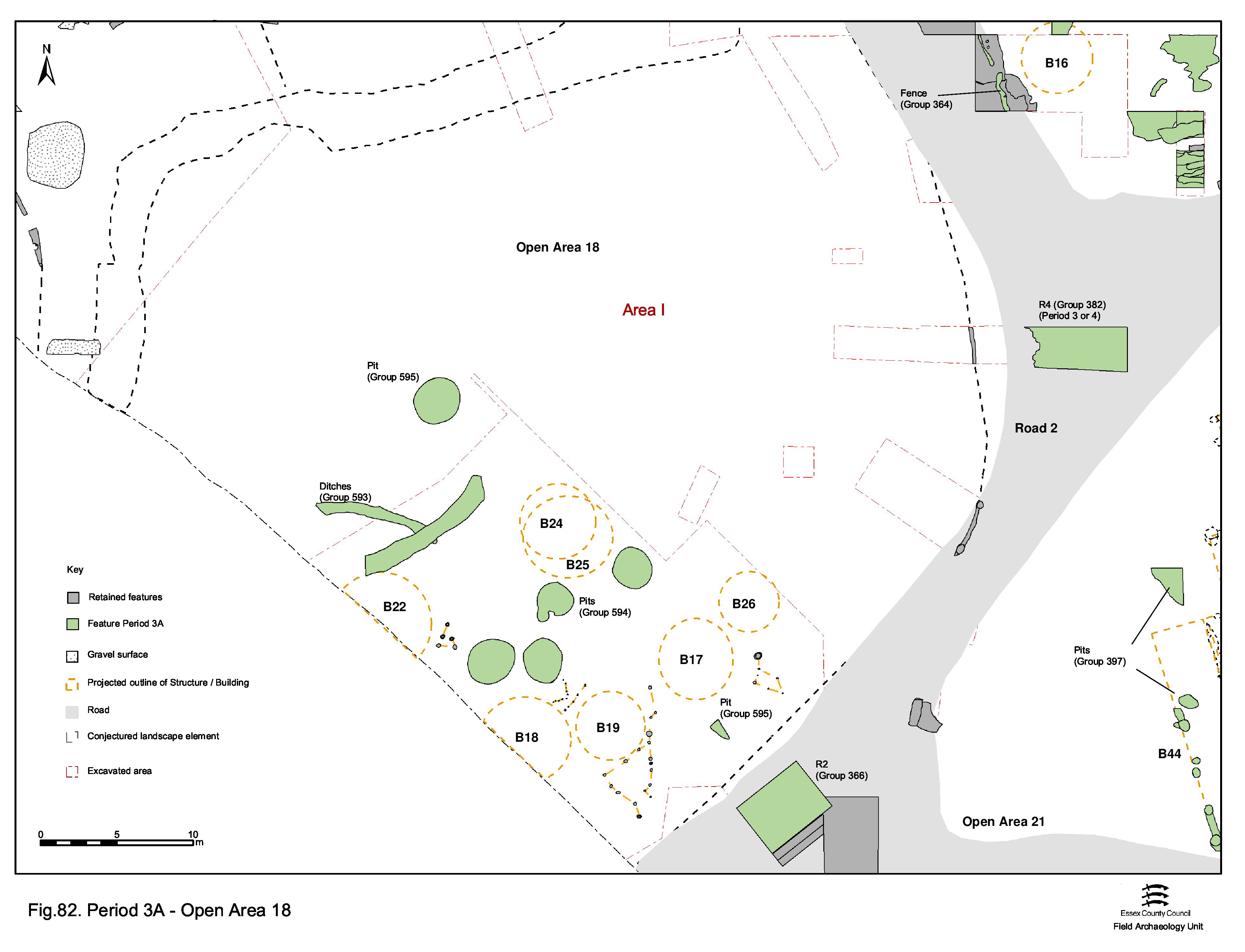
Occupation of the gravel-surfaced interior of OA18 continues into the early Roman period proper (Period 3A) with no recognisable change in the form or character of its buildings and boundary fences from Period 2B, other than the encroachment of pitting (Group 594, 595). (Figure 82) Minor layout changes occur, with some of the roundhouses passing out of use and being replaced, with the occupation of others presumably persisting into the later 1st century AD.
However, during the late 1st to early 2nd century AD the surface is abandoned, and the structures upon it cleared. This act of abandonment (marking the onset of Period 3B at this location) appears sudden and probably deliberate, with the largely unworn gravel surface being buried under extensive dumping of rubbish-rich silts (Group 599) and middening (Group 607, 609). Rutting (Groups 599 and 602) in the top of both the dump and midden deposits may be a product of the importation of this material into OA18. It is postulated that this dumping episode is a concerted effort to raise the ground surface by at least 0.3m. The catalyst for this is unidentified, but it could be undertaken in response to seasonal or freak flooding of this part of the settlement. It is notable that, at this time, the ground surfaces of OAs 18 and 19 seem to be as much as 0.7-0.8m lower than adjacent OAs 21 and 28 in Period 2. Both have their average surface level raised by 0.25 to 0.30m some time between Periods 2B and 3.
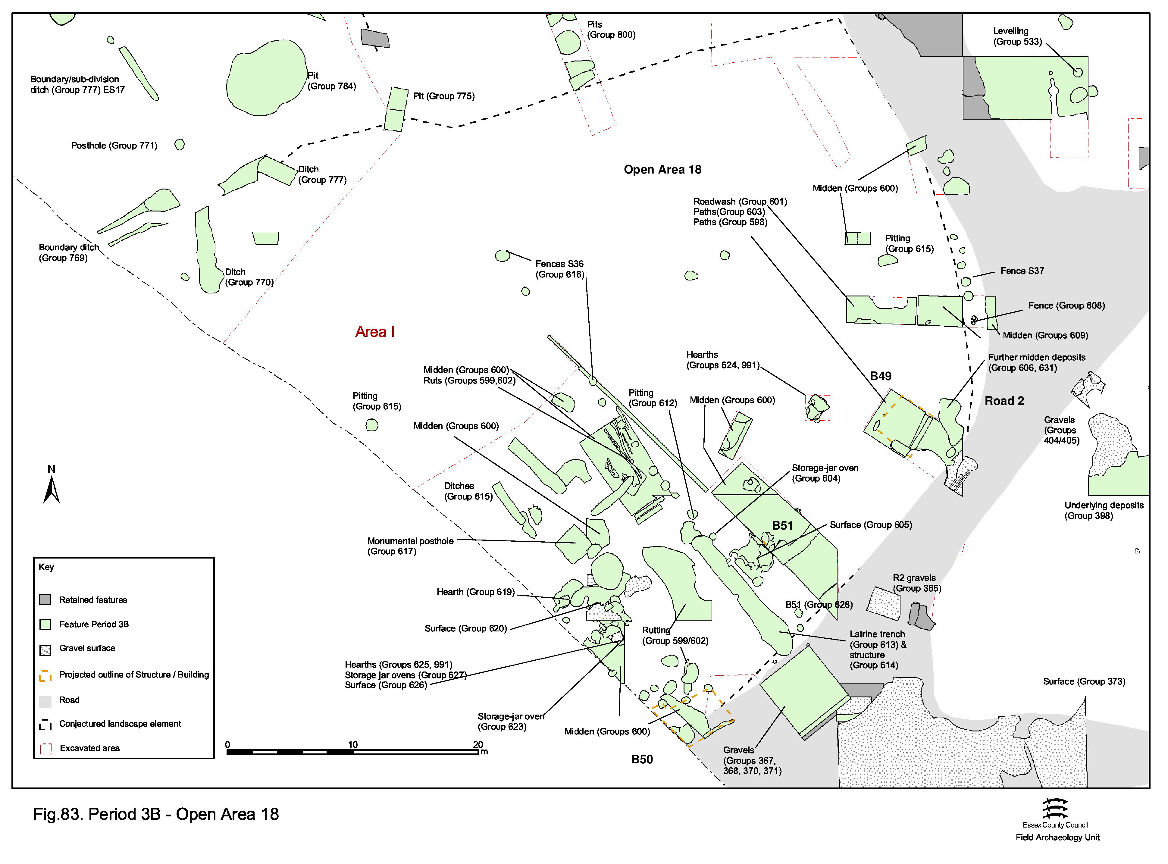
Following the raising of the land surface, OA18 is reoccupied. However, this subsequent activity is markedly different from that on the earlier gravel surface. The enclosure now appears to be subdivided by fenceline Structure 36 (Group 616), running away from the Road 1 and 2 frontage into at least two sub-plots (Figure 83).
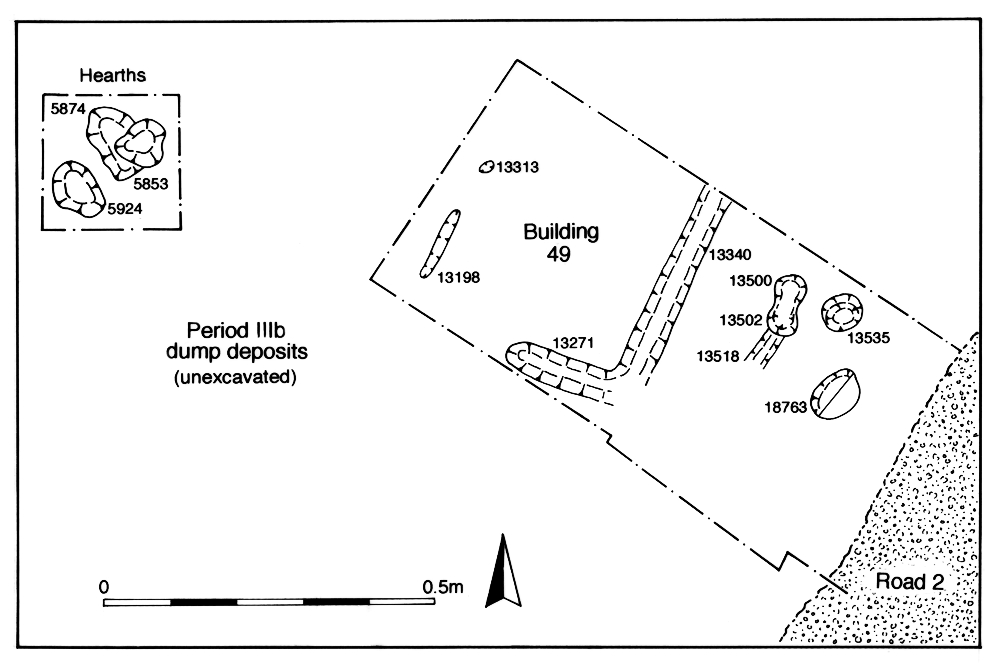
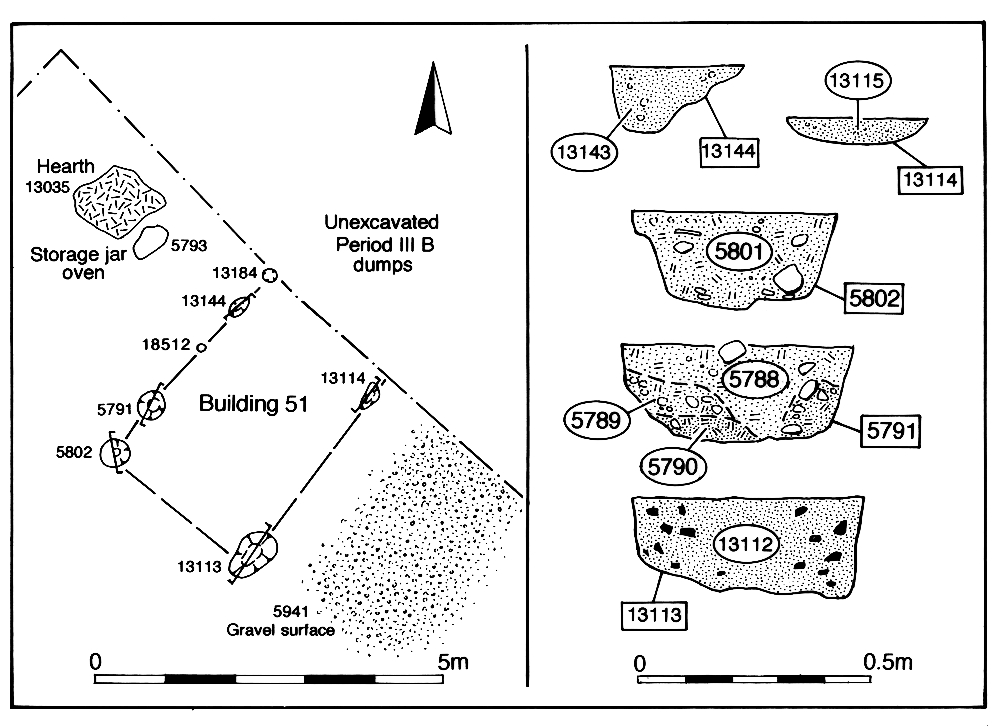
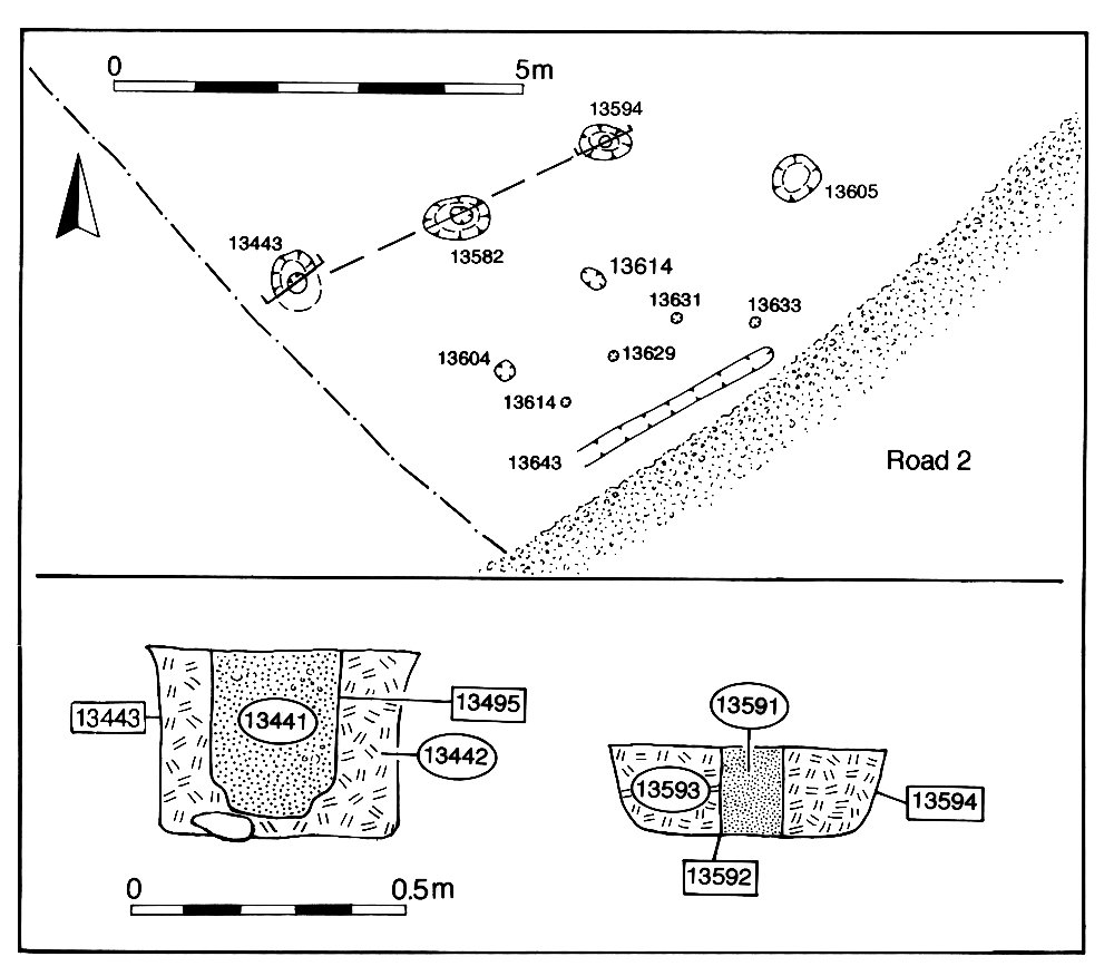
The sub-plot to the east is separated from the roads by fenceline Structure 37 (Groups 608-610) and contains Buildings 49 and 51 (Groups 618, 628) along its frontage (Figures 84-85). Hearths and storage jar ovens (Groups 604, 624, 629, 632, 760, 991) seem to occur in close association. Early Roman rubbish pitting is restricted to a sole excavated example to the north of Building 49 - 13469 (Group 611) - which may include a placed deposit of a complete ceramic bowl at its base. However, midden-like dump deposits (Groups 606, 631) are present in this eastern part of OA18 and may account for its lack of pits.
That part of the enclosure to the west lies largely open and is notably almost pit-free (Group 612). Its principal features are a deep 'trench' 25049 (Group 613, Group 614), possibly a latrine (Figure 86), a likely monumental post-setting 13331 (Group 617) and a number of hearths and storage jar ovens (Groups 619, 623, 625, 627, 991), such as those that also feature in OA19. Some are associated with localised areas of hardstanding (Groups 605, 620, 626). A tentative building, Building 50 (Groups 621, 622), lies alongside Road 2 (Figure 87). A number of possible gravel paths (Group 603 is the most convincing) are recorded; these run parallel to Road 2.
It is posited that, as part of this Period 3B change of use, this open area is accorded a close functional association with both OAs 19 and 21, perhaps constituting part of the public area around the temple itself. This is the only demonstrable incidence of an early gravel surface being abandoned so early and so completely, perhaps due to an expansion of activities and facilities associated with the religious function of this part of the settlement. If indeed the case, this would seem a further indication of the increasing importance of the temple complex.
The partial excavation of poorly understood sequences of surfaces, build-ups and cut features has not been conducive to gaining a full understanding of the nature and function of OA19 in the early Roman period. However, what is apparent is a clear east-west division in the nature of its land-use, with occupation-type activities almost exclusive to its west end, paralleling that of adjacent OA 23/45. The complexity of development and change within the west of OA19 necessitates the imposition of two sub-phases.
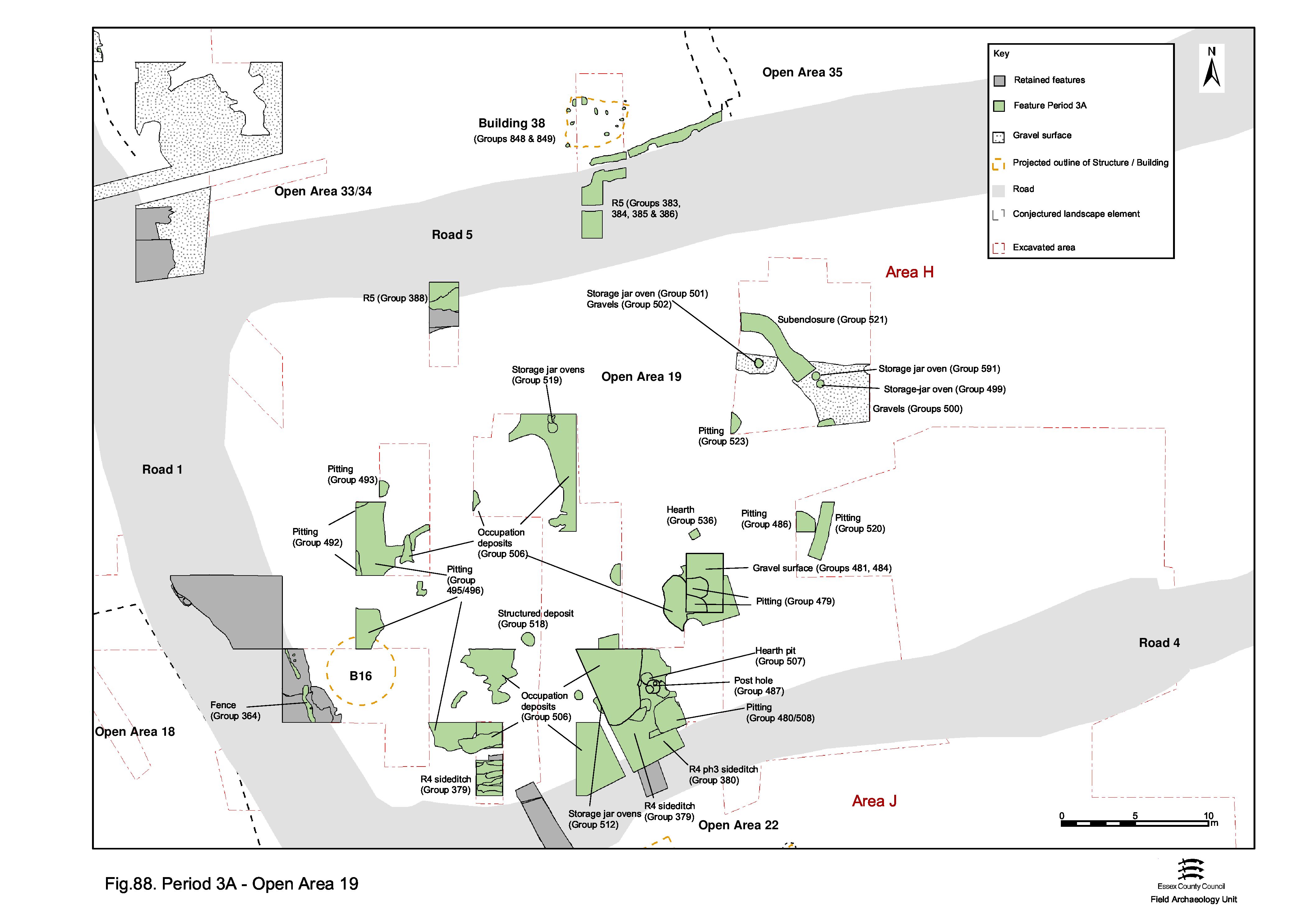
At the west end of OA19, within Excavation Area H (Figure 88), closest to the perceived settlement core, late 1st-century activity includes an episode of patchy resurfacing both across the interior of the area (Groups 488, 490) and along flanking Roads 4 and 5. Presumably associated with this, sporadic deposits of dirty redeposited brickearth (Groups 495, 496) are laid down, apparently to consolidate and level the remains of earlier Period 2B features and the site of Building 16, cleared early in this period.
Contemporary with this resurfacing, the Period 2B ovoid sub-enclosure (Group 194) is replaced by a seemingly similar, but slightly larger, sub-enclosure (Group 521); this time with an entrance at its east end. This ditch and entrance may to all intents and purposes mark the eastern extent of a distinct land-use entity occupying the west end of OA19 - particularly as this coincides with the eastward line of what becomes the formalised temple precinct frontage later in Period 3 and is itself formalised with a boundary wall by Period 5. The full form and function of this ditched sub-enclosure within OA19 are far from clear. Only its eastern side is confirmed by excavation, although it is conjectured that its south may run alongside Road 4, perhaps terminating as 25256 (Group 380) and cutting defunct roadside ditch 25254. It is further conjectured that this sub-enclosure is perhaps open along the Road 1 frontage.
Small-sized pits of the late 1st to early 2nd centuries are relatively numerous (Groups 479, 480, 492, 493, 518, 520, 523, 530), and are evenly scattered across this end of OA19. Among these, pit 6201, located at the perceived near-centre of the sub-enclosure, contains a placed deposit. However, the most distinctive feature of the enclosure at this time is the high incidence of 'storage jar ovens' (Groups 477, 499, 501, 503, 512, 519, 591) and a tile-built hearth base (Group 536), largely located along the south side of the enclosure, but also in the vicinity of its eastern entranceway. The southern oven group displays a high degree of replacement of their structures, suggesting prolonged cooking activity at this location. Disposal of burnt debris is apparent in pits (Groups 486, 507) located in close proximity to these ovens. The nature and likely function and significance of these and other similar structures is discussed further elsewhere (Vol. 1, Chapter 6) and it suffices to say here that they are interpreted as indicating the outdoor production of foodstuffs, possibly in close connection with the adjacent temple complex - either in the form of providing visitors with sustenance, possibly on a commercial basis, or else with foodstuff offerings for ritual use. The similar occurrence of ovens located in a roadside position within OA18 is also noted. No buildings can be identified within the oval enclosure, though the limited extent of investigation is perhaps simply not conducive to the recognition of their remains.
Later in the period, the ovoid sub-enclosure ditch and the storage jar ovens occupying its interior are abandoned and covered by the second of the patchy early Roman surfacing episodes (Groups 509, 510) that extends across the west end of OA19 - probably augmenting surviving parts of the Period 2B surface of the enclosure interior. Localised areas of gravel surface (Groups 500, 502, 516) overlie some of the defunct ovens and appear to be repairs to the earlier surface. This represents the beginning of an episode of marked change in the nature and function of the west end of OA19 that is speculated to be contemporary and closely associated with the Period 3B remodelling of the adjacent temple complex. The central feature of this remodelled end of the Open Area is substantial timber-lined well 6280 (Group 531) (Figure 90) positioned close to the centre of the plot, broadly equidistant from Roads 1, 3 and 4. Pits of the mid- to later 2nd century appear to be sparse (Groups 532, 654). It is postulated that the earlier pitting and cooking activities are curtailed as the likely communal/public function of this area is enhanced by the insertion of the well. In the light of this, and of the close proximity of the west end of OA19 to the temple complex, its speculative identification as a communal space, such as a market place, may be a reasonable one.

To the east of the ovoid enclosure, OA19 appears to have been relatively free of any intrusive features throughout Period 3 (Figure 69, Figure 70), pit 16469 (Group 535) being the only one identified. Toward the eastern end of OA19, Late Iron Age Building 6 may survive into the early Roman period, or at least through the transition period of the mid-1st century AD. However, it is no longer in existence by the end of the 1st century, being cut by ditch 25157 (Group 410). Although now cut by the ditch, it may be presumed that the Period 2B gravel surface continues in use for some time.
Perhaps at the same time as the early 2nd century resurfacing and change of use at the opposite end of OA19, the earlier gravel surface is covered by a second, laid down directly on it and over ditch 25157. Ditch 25158 (Group 411), although lying beyond the surviving extent of the two gravel surfaces, is parallel with 25157 and could constitute its replacement and is possibly supplemented by a fenceline (Group 412). Otherwise, there is almost no evidence for early Roman features and structures occupying this surface, although it is conceded that some could perhaps be among the unphased post-holes recorded here, but even these are relatively few in number. It is therefore concluded that much of OA19 continues to function as an open space throughout the early Roman period, alongside that in front of the temple complex.
The Southern Zone enclosures, as created in Period 2B, continue to function as distinct land-use entities throughout Period 3 (Figure 71). Their original boundary ditches appear to have become infilled by the later 1st century, but the lack of encroachment upon them by later activity, such as pitting and alternative boundary alignments, suggests that their lines continue to demarcate the plot divisions - perhaps now being marked by some less archaeologically tangible means, such as slight fences or hedges. As such, unchanged boundary positions are presumed and only specific modifications made to them described here.
As well as uniformity and similarity of layout, the Southern Zone enclosures share general commonality of function - probably as smallholdings in which small-scale cultivation, animal rearing, crop processing and craft production is carried out in close proximity to the dwelling. However, it is possible that OA28 conforms more to those of the Central Zone and may provide a glimpse of the nature of further enclosures that must front onto Road 2 as it extends off to the south-east, beyond the investigated area of the settlement.
A degree of change from Period 2B is perceived within the enclosures, with fewer pits containing an increased quantity and variety of, by now, Romanised material. This may suggest the adoption of practices that result in waste material accumulating for a longer period before finding its way into (fewer) pits - perhaps the introduction or increased use of managed maddening.
Some degree of change is evident within individual enclosures, particularly in the case of OA28. Sub-phasing of activity has been attempted, but this is neither particularly consistent between enclosures nor necessarily meaningful with regard to pitting.
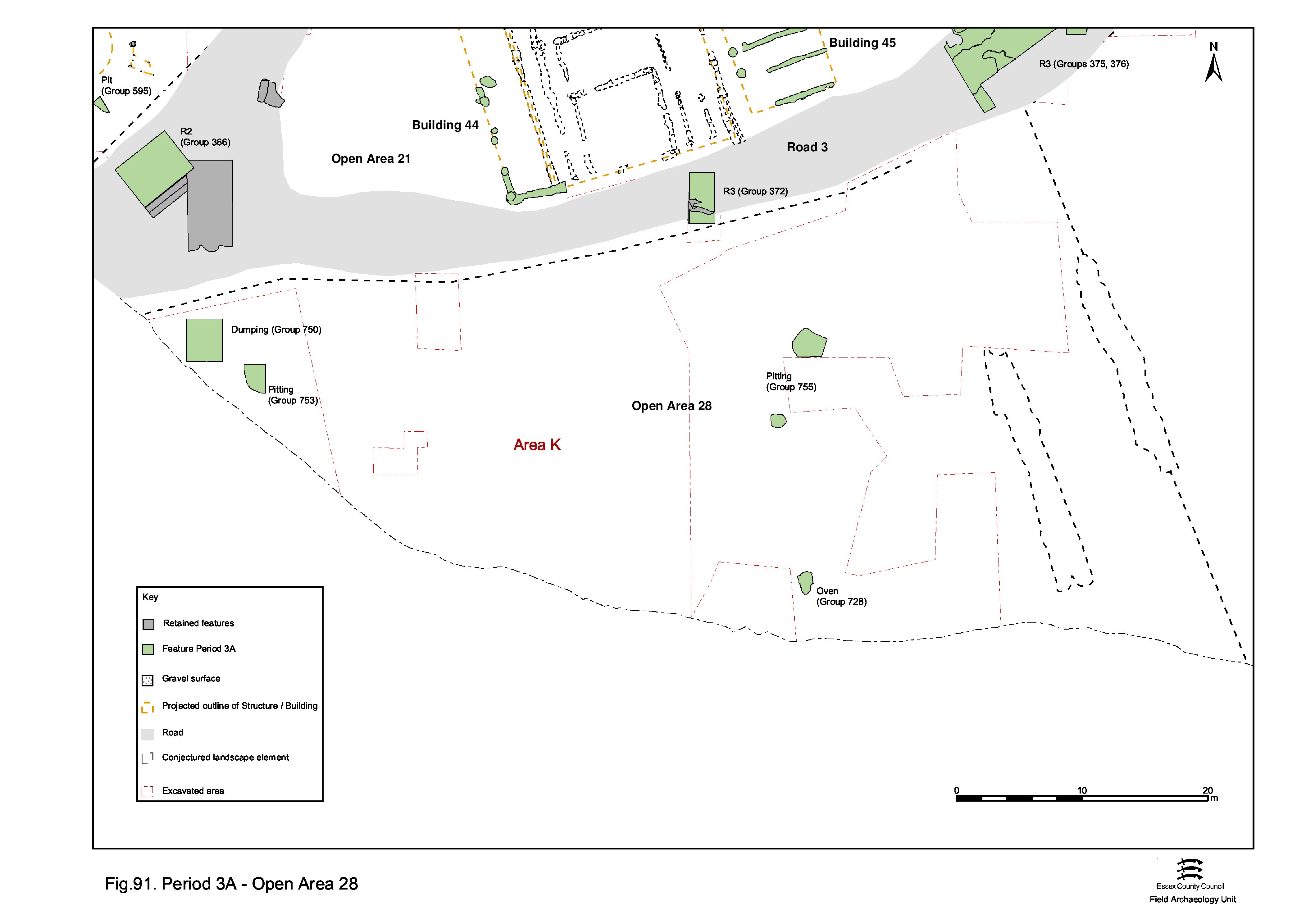
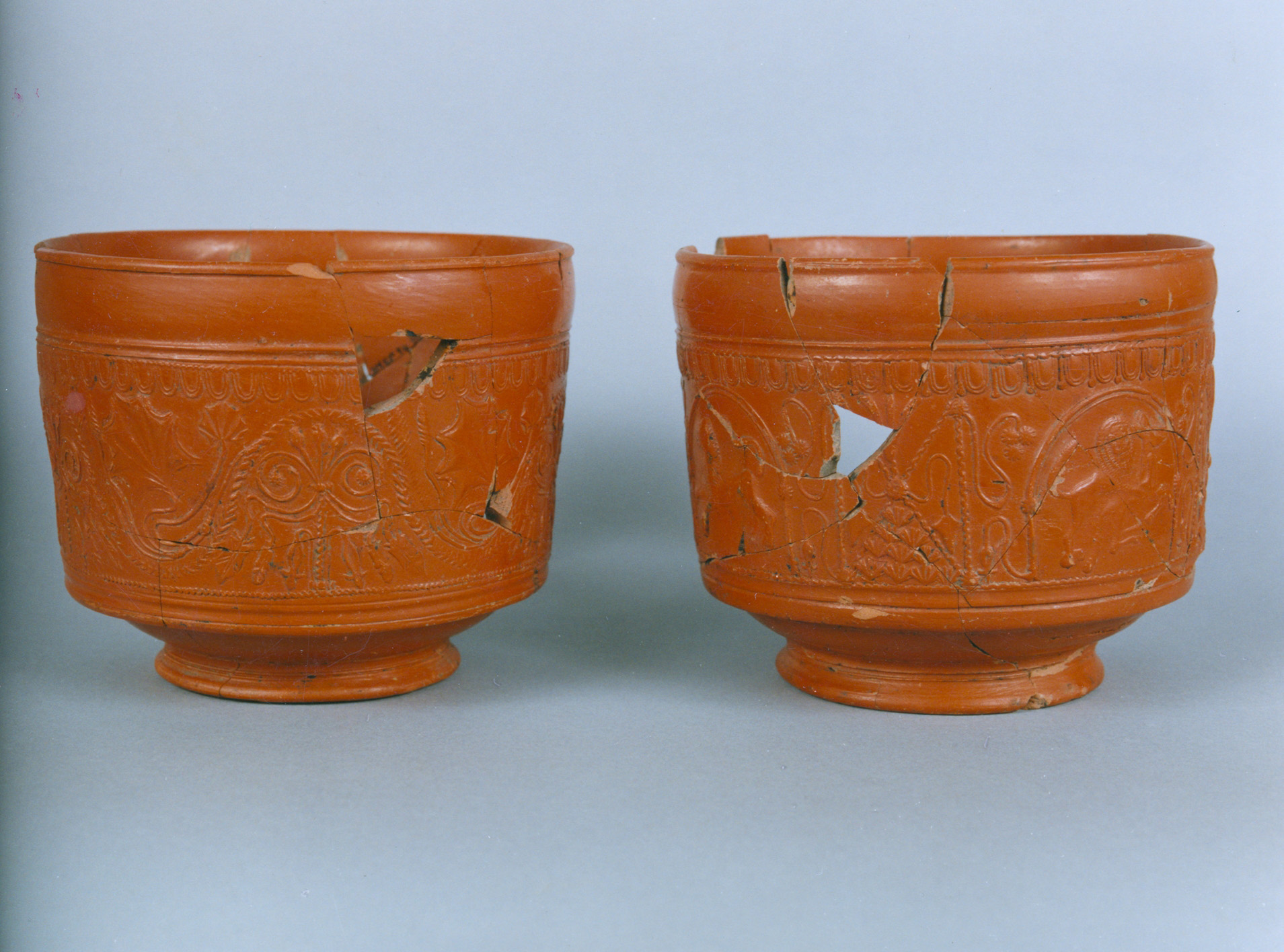
Later 1st and/or earlier 2nd century remains indicate direct continuity of occupation within this enclosure plot between Periods 2B and 3 (Figure 91). A building, probably surviving from Period 2B, may be assumed to be located further west within OA28. Tile-built oven or drying floor 4021 (Group 728) and pitting (Groups 729, 753, 755) are generally positioned away from the Road 3 frontage, toward the perceived rear of the plot. Pit 4458 contains a placed deposit of a whole pot and possible food offering. The presence of structured deposit 4148 (Group 732), comprising a pair of decorated samian bowls (Figure 92) placed together with a Late Iron Age potin coin (SF405) and covered with a large grog-tempered vessel lid, closer to the Road 3 frontage is also noted.
 Period 3B
There is no distinct change evident within OA28 until later in Period 3 (Figure 93) when the enclosure is subdivided by the imposition of likely fence Structure 27 (Group 727), which seemingly marks the functional division of the enclosure interior between domestic occupation to the west and manufacture/processing and disposal to the east.
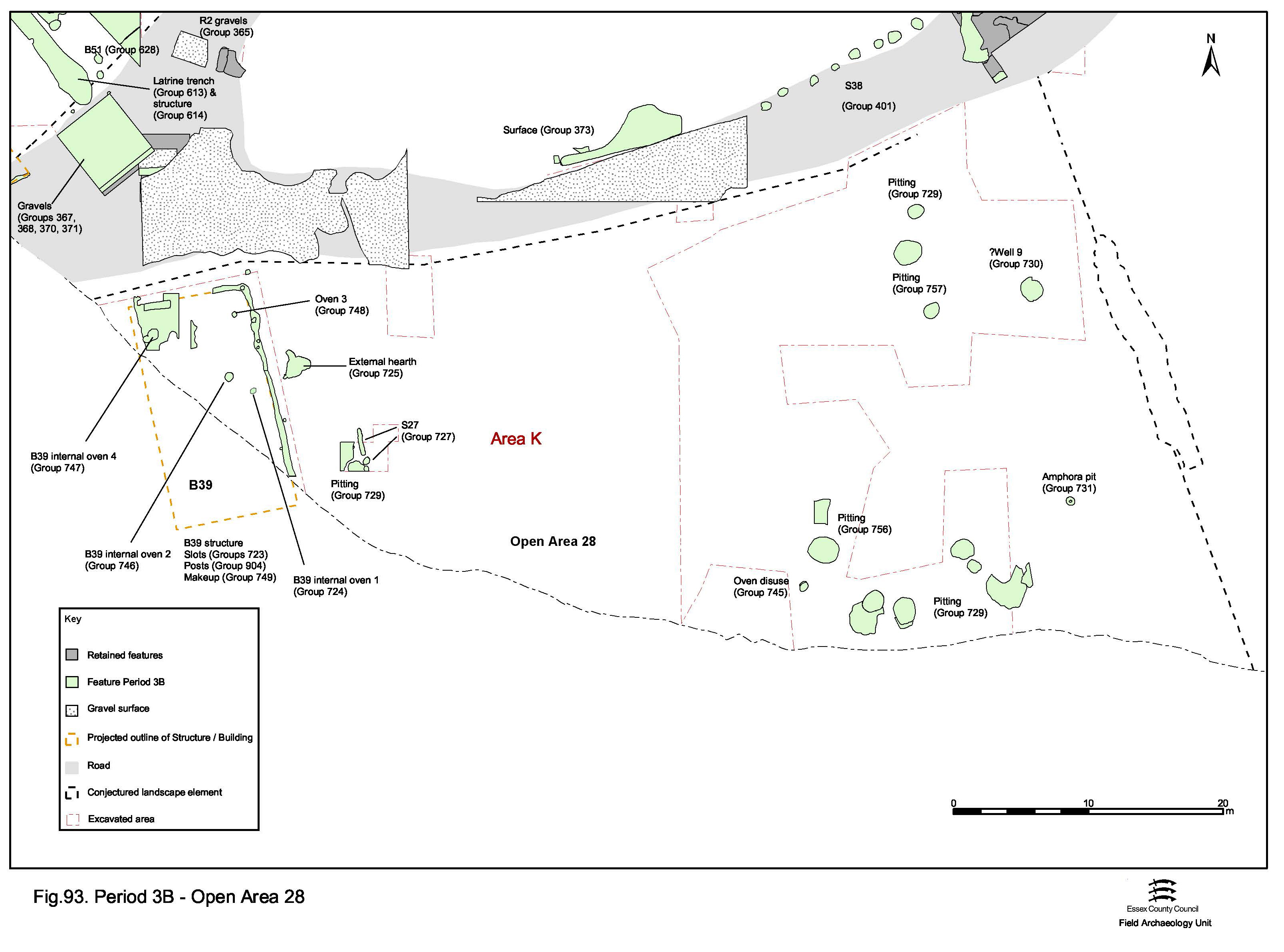
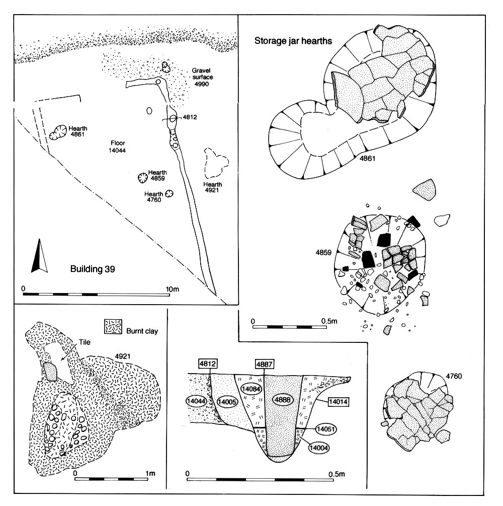
Large rectangular Building 39 (Groups 723, 904) (Figure 94) is constructed within the west side of OA28, positioned alongside, and fronting onto, the junction of Roads 2 and 3. The probable mid-2nd century date for its construction is based on levelling deposits (Groups 749, 750) and Period 3A pit 14006 (Group 753), both of which it overlies. The inclusion of a coin (SF5435) in the foundation of Building 39 (slot seg. 4812) is regarded as a likely ritual deposit. The building certainly appears to survive until the later 2nd century and, if a further coin (SF14145) of AD 223 from its probable gravelly silt floor (Group 759) is taken at face value, may not fall out of use before the second quarter of the 3rd century. Although no interior room divisions are apparent in its plan, the building contains four storage jar ovens (Groups 724, 746-8) that are regarded as being contemporary with its use. An area of gravel surface (Group 726) lies in front of Building 39, alongside Road 3. External hearth 4921 (Group 725) is located just to the east of the building along with sole pit 4726 (Group 757).
East of the OA28 subdividing fenceline, two clusters of post-holes, only a few of which can be reliably dated to the early Roman period, are present. While both circular and rectilinear arrangements can be (very) tentatively construed, the limited extent of excavation and potential distribution bias created by pit truncation (particularly by unexcavated examples) means that it is not possible to identify any further building plans with any degree of certainty. However, these post-holes must belong to what may be a multiplicity of potentially multi-phase structures, at least some of which are likely to occupy the plot contemporaneously with Building 39.
Pits (Groups 756, 757), while being relatively numerous, are deliberately located away from Building 39, suggesting they are in contemporary use. These early to mid-2nd century pits are not dissimilar from earlier ones and contain large mixed finds assemblages of a domestic nature together with a smaller ?metalworking waste component. The incidence of placed deposits of complete ceramic vessels, inserted into the tops of two rubbish pits is noted; a beaker in pit 4048 and a holed storage jar in pit 4526.
An inverted Dressel 20 amphora occupies purpose-made cut 4582 (Group 731). Its function is unclear. Such features have elsewhere been interpreted as urinal soakaways (e.g. Causeway lane, Leicester), though its position on the OA27/28 boundary is potentially significant in terms of the once-whole amphora (with its spike projecting upwards) perhaps constituting a surveying point for the laying out of this part of the wider settlement - particularly the boundary alignment shared with the OA23 (temple) and OA19 frontages.
Alongside the likely east boundary of the plot is well 4536 (Group 730); presumably the principal water source for both the occupation and production/processing activities undertaken within OA28 and perhaps shared with adjacent OA27. However, Period 3A oven/drying floor 4021 evidently passes out of use either before or during the early/mid-2nd century.
Late Period 2B Building 36, located toward the rear of the enclosure (Figure 95), may survive into Period 3, but it is likely that unexcavated/unrecognised replacement structures are subsequently located elsewhere in its interior - most probably toward Road 3, as is the case in OAs 25 and 26. Indeed, vestiges of an uninvestigated structure can be discerned in the north-west corner of the enclosure on the pre-excavation plan of this vicinity.
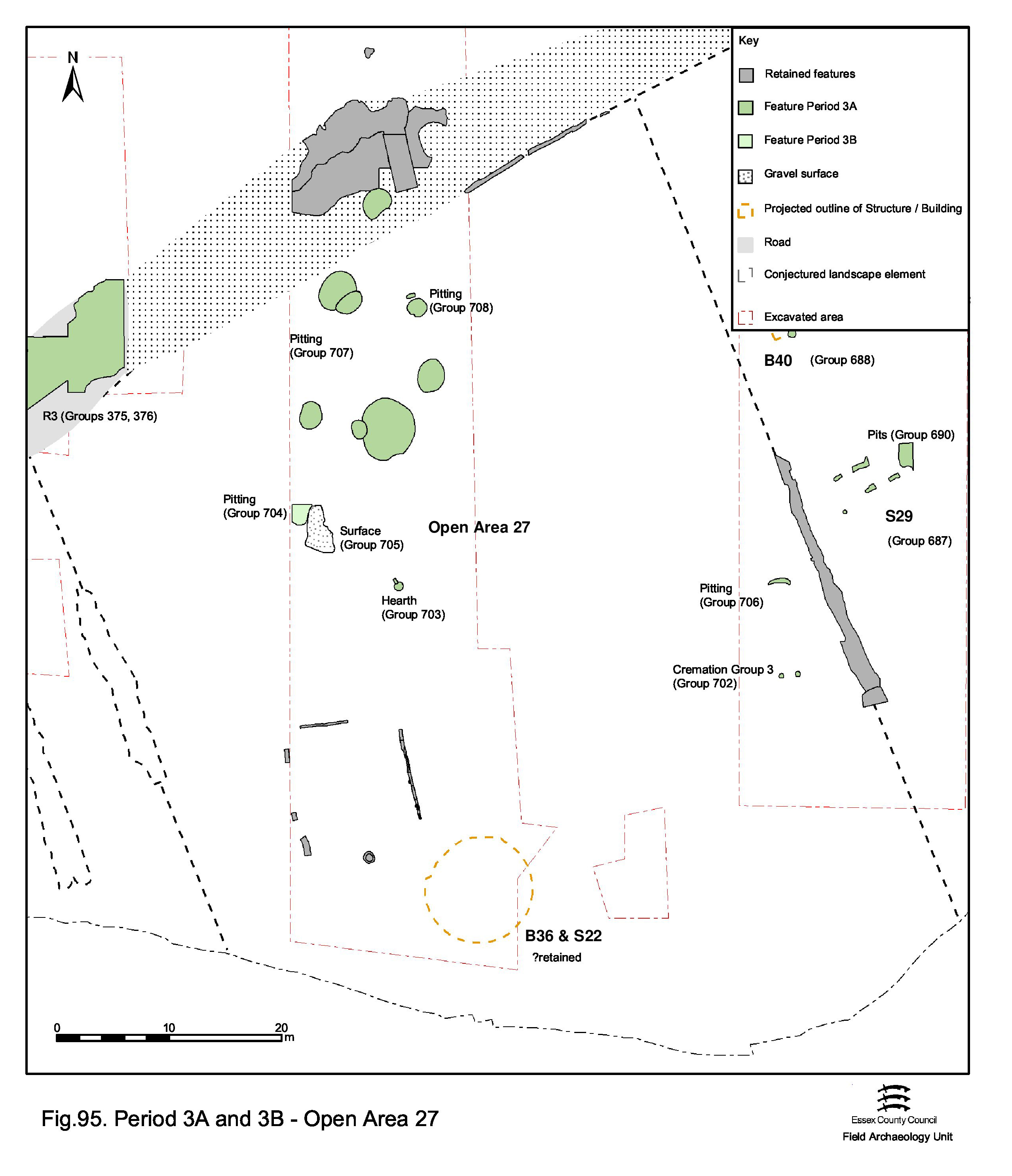
While the main evidence for continued OA27 occupation is in the form of rubbish pits (Groups 704, 706, 707) with fills of a domestic character, other occasional features such as hearth 14491 (Group 703) (Figure 96) located in the middle of the enclosure, and well 4536 (Group 730) at its western edge, suggest that activity is not restricted solely to disposal. A pair of cremation burials, 15017 and 15040 (Group 702), is located close to the eastern boundary of the enclosure and toward its rear. Isolated from most contemporary activity, and almost certainly deliberately in a peripheral position within the enclosure, these graves present an interesting example of seeming 'backland' burial practice (Vol. 1, Chapter 7).
Toward the Road/Track 3 frontage lies small, elongated and isolated pit 20008 (Group 708). Containing eleven complete or near-complete vessels and substantial parts of three more, this is evidently a structured deposit. However, since these are exclusively domestic greyware vessels dated to c. AD 70, it is conjectured that this deposit derives from the occupation of the enclosure - perhaps representing the decommissioning of an entire ceramic assemblage of a household. The significance of this deposit is discussed further elsewhere (Vol. 1, Chapter 6), but suggests that such religious/superstitious practice is not an uncommon aspect of activity within occupation enclosures of the settlement in Period 3.
This highly specific and seemingly deliberate deposit contrasts markedly with the extremely mixed assemblage from larger, adjacent, pit 20010 (Group 707), which dates to the late 1st-early 2nd centuries and is therefore broadly contemporary. The majority of Period 3 pits are concentrated towards the front of the enclosure (Groups 704, 706, 707) and tend to contain large but restricted finds assemblages; mainly pottery with small amounts of animal bone and daub. In addition, modest quantities of tile and oyster shell are now present. Metalwork content is low, with no sign of debris such as cast waste, slag or mould fragments. Pit 14579, including a pedestal vessel displaying likely deliberate breakage, is identified as containing a further structured deposit.
It is notable that the OA27 pits and cremation burials do not transgress the boundary lines of the enclosure, implying that these are still marked by visible features such as fences or hedges. However, early Roman pit 20187 (Group 707) does encroach onto Road/Track 3. This is in fact the latest addition to an inter-cut cluster of Period 2B pits that encroach upon the road, and perhaps suggests that the OA27 frontage is not particularly fixed.
It is likely that, as is perceived to be the case with the other enclosures of the Southern Zone, the original Late Iron Age boundary as defined by ditch 25082 has passed out of use by Period 3, but its line is perpetuated in some way; perhaps by a hedge. What is particularly apparent in this enclosure is the clear differences in land-use between front and rear.

Occupying a position on the west side of the plot toward the Road 3 frontage are Buildings 40 and 41 (Figure 98). An array of slots and post-holes defines Building 40 (Group 688), which probably represents a replacement of Period 2B Building 5. Although tentative, they define an east-west aligned building within which a central aisle or corridor set in slots was flanked on either side by a post-built room. The extant evidence conspicuously fails to define any of the corners of the building, but it may have been as large as 14m by 6m. This structure differs radically from its probable predecessor, Building 5, in terms of shape, size and complexity. A hearth 15465 (Group 898) either pre-dates this building or is sited in its western room. One of its constituent post-holes (15466) contains several pieces of iron strip, some slag and hammerscale and a copper-alloy boss. The ashy fills of nearby pit 15641 (Period 2B) contain at least four iron sheet fragments, so it is possible that the metalworking evidence from 15466 is residual. However, it is equally possible that the hearth is misplaced in Period 3 and better seen as associated with 15461 in Period 2B. The intrinsic dating of the building is poor and indicates only a general early Roman date. Period 3 pit 15902 which pre-dates it (Group 899) is of probable mid-1st century AD date. Judging by the pits that post-date the building (Group 692), it falls out of use by or during the second half of the 2nd century AD.
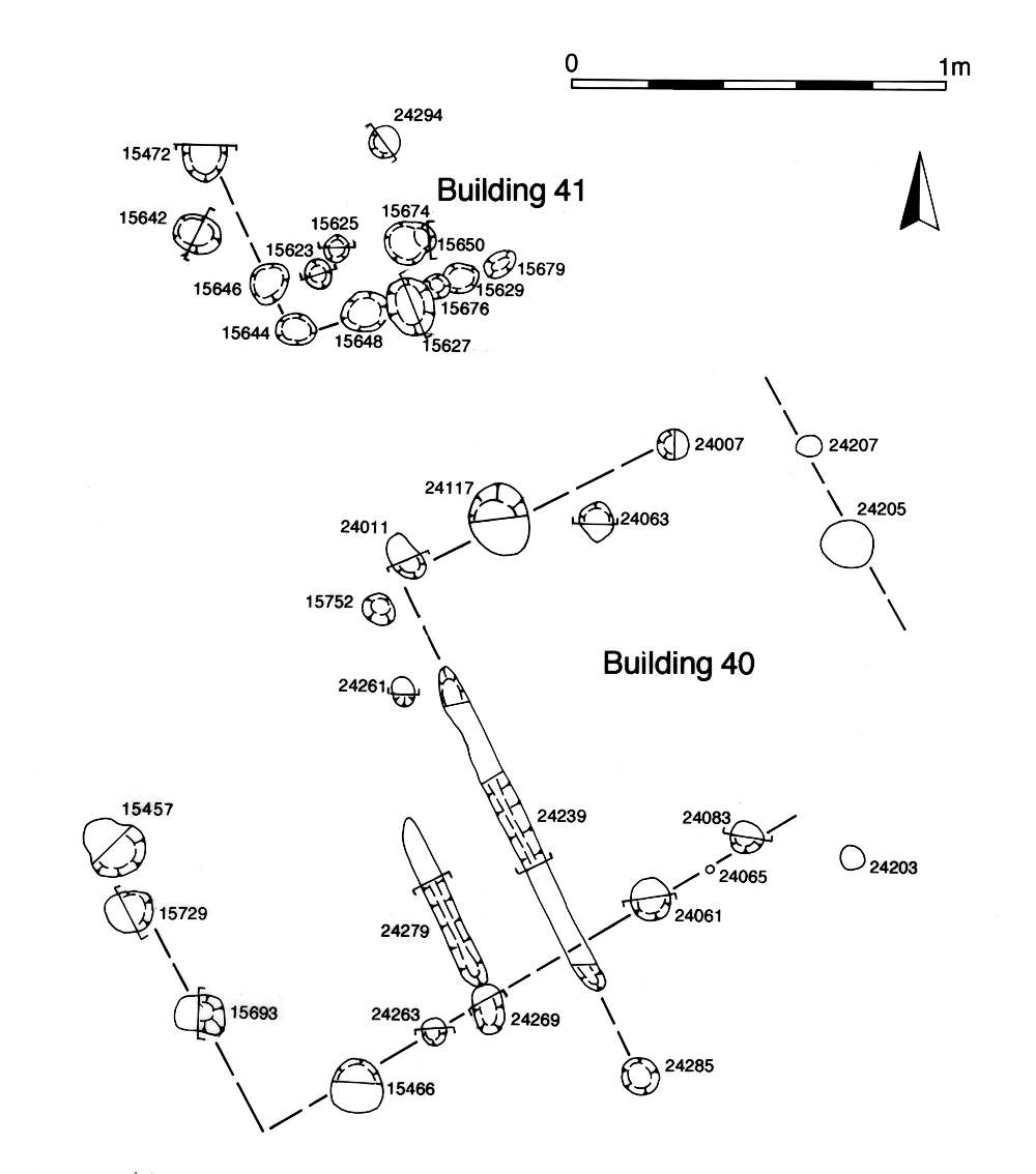
Building 41 (Group 689) lies only c. 3.5m to the north (Figure 98) evidenced by a concentration of post-holes, some of which define a close-set alignment parallel to the north wall of Building 40. The excavated evidence defines a structure that cannot be much bigger than 3m by 3m. It may represent a northern extension of Building 40, but its distinctive construction rather suggests that it is an out-building of some sort. Similarly proportioned close-set posts for such a small building have been interpreted as supporting raised floors for granaries. The dating for Building 41 is as imprecise as that for Building 40.
An orthogonal arrangement of slots over the southern half of OA26 likely constitutes a reorganisation of this rear part of the enclosure. Structures 29 (Group 687), 31 (Group 682), 32 (Group 683), slot 25165 (Group 685) and additional Structure 33 (Group 684) together define the remains of regularly spaced internal divisions, perhaps fences enclosing gardens and/or pens, replacing the Period 2B subdivisions (see OA26, Period 3). It is interesting to note that while this new layout is broadly orthogonal to the eastern side of Open Area 26, it is not in relation to the alignment of its western boundary. Of late 1st-century inception, at least some of these internal divisions may survive into the 3rd century AD.
External cobble-lined hearth 23157 (Group 686) lies on the northern limit of the garden sub-enclosures. In terms of its construction and apparently deliberate positioning on top of early 2nd-century pit 23032 (Group 681), it is similar to the hearths of Period 2B and, while no specific function can be attributed to this later hearth, it implies similar patterns of activity continuing from Periods 2B to 3 within OA26.
Pitting in OA26 is considered both in relation to Buildings 40 and 41, major developments, and of the subdivisions across its rear. On the western side of the enclosure, one early Roman pit (Group 899) can be identified that pre-dates Building 40 and has been noted above. Otherwise, the principal concentration of pitting (Group 691) dates to the late 1st to early 2nd centuries and lies between Building 40 and Road/track 3. These pits appear to respect the footprint of Building 41 (the out-building) and are very likely to be associated with the use of both buildings. One pit of particular note is 15573 (Group 691) which includes a range of iron artefacts comprising 'shackles' (SF6670), a ring (SF6673), chisel (SF6668) and a number of nails. Most significantly, a complete iron bloom (SF2676), although found during machine removal of the topsoil, directly overlies this feature and is almost certainly derived from it.
A little to their south, a second cluster of pits (Group 692) post-dates Building 40 and other pits (Group 900) lie within the building's footprint, but have no stratigraphic relationship with it. Some (e.g. 15917 Group 692) are datable to the mid/later 2nd century and provide a date by which Building 40 is out of use. Another pit (24312 Group 690) is of similar late 2nd century AD date (AD 160-200). Fewer pits of early Roman date, mostly of mid-1st to early 2nd century date, are present on the eastern side of the enclosure (Group 681).
As with the other Southern Zone enclosures, it is surmised from the lack of encroaching features on OA25's Period 2 boundaries, that these are perpetuated largely by hedges in Period 3 (Figure 99). Little substantive change is evident within the enclosure interior. The lack of Period 3 encroachment on the footprint of Period 2B Building 32 suggests that the building survives throughout the late 1st to mid-2nd centuries. Similarly, Building 31 is not encroached upon by pitting until the mid-2nd century AD, by which time pit 11092 (Group 667) is cut through its northern end. These buildings are therefore presumed to continue in use and to occupy the northern (front) part of OA25 through Period 3. Significant differences in land-use are, however, discerned between the east and west sides of the enclosure interior.
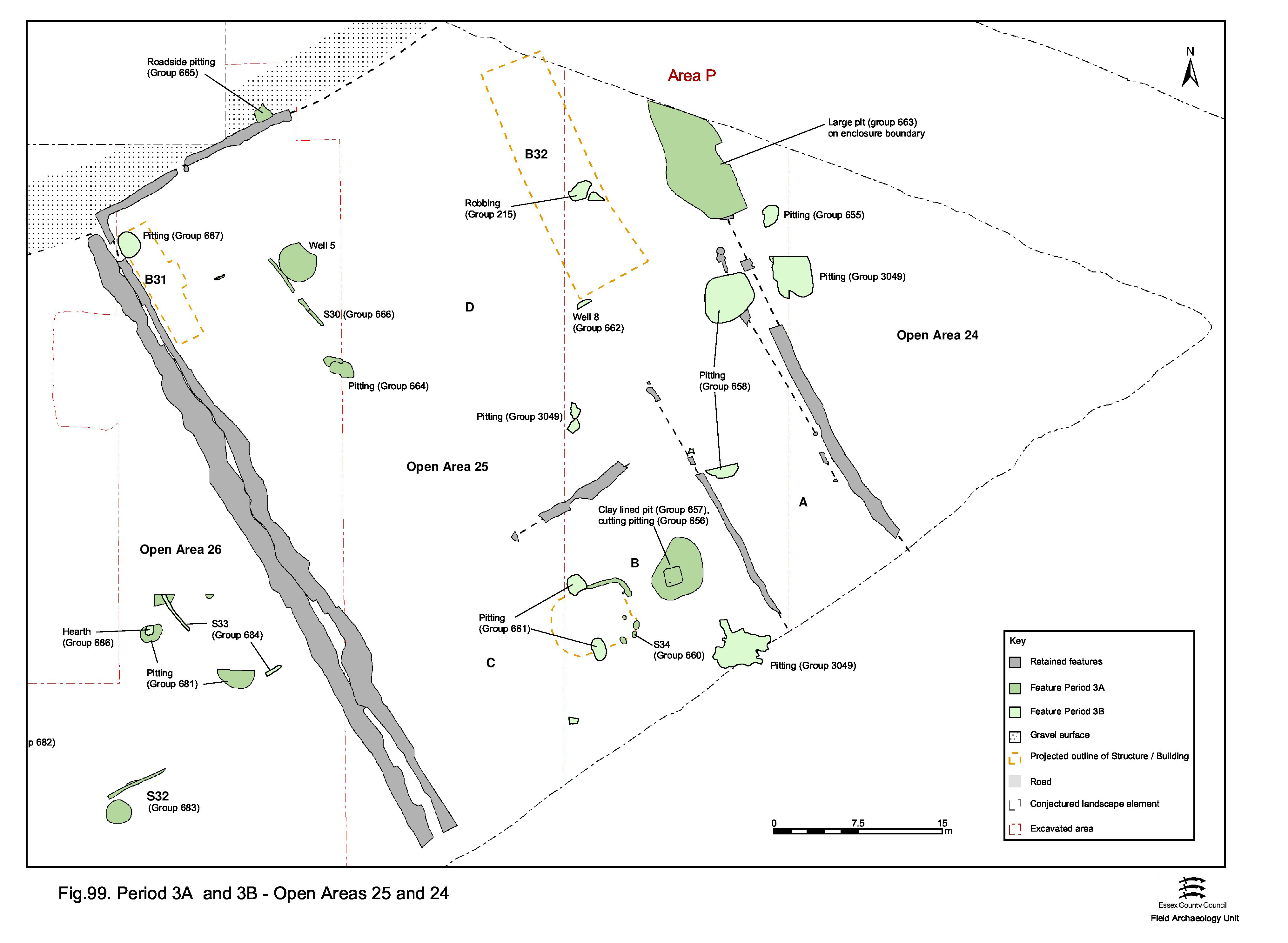
On the west side, fenceline Structure 30 (Group 666) defines a sub-enclosure to the rear of Building 31 the interior of which is conspicuously clear of early Roman pitting. Though reduced in number compared with the preceding Period 2B, pits (Group 664) continue to be dug alongside Building 31, though the lack of metalworking debris in these may indicate a change to more general domestic activities in this vicinity. Technically outside the enclosure, inter-cut pits 11347 and 11731 (Group 665) demonstrate the continuation of occasional Period 2B encroachment of Road/track 3 into the early Roman period.
On the east side of the enclosure, the boundary with OA24 is both modified and perpetuated by the imposition of substantial sub-rectangular cut 25221 (Group 663) along its northern extent. Extrapolated to be c. 27m long and 6m wide, interpretation as a gravel quarry is unconvincing, particularly considering its episodic re-cutting/cleaning in the 3rd century. The lack of variety within the artefactual assemblages retrieved from its fills, in particular the absence of animal bone, also make it difficult to view the feature simply as a waste pit. This boundary pit/trench is reminiscent of 25212 (Group 845) in the Northern Zone of the site, although this further example dates to Period 5.
To the rear of Building 32 few pits are in evidence. However, the creation of possible wet-storage pit 8540 (Group 657), located in close proximity to Structure 34 toward the south end of the enclosure, indicates ongoing activity through Period 3. Structure 34 (Group 660) is a small gully- and post-built sub-rectangular building with a probable doorway in its eastern side. It potentially overlies the Period 2B internal subdivision of the rear of the enclosure and is cut by pit 8515 (Group 661) of 2nd century AD date. The wet-storage pit seems deliberately cut into the fills of early Roman pit 8540 (Group 656), the sole identified pit of this date in this vicinity of the enclosure.
Later Period 3 activity in OA25 includes encroachment upon the footprint of Building 31 by mid-2nd century pit 11092 (Group 667), almost certainly indicating that this building is by this time out of use and presumably cleared. There is, however, no evidence that Building 32 is yet out of use. Well 8989 (Group 662) is located immediately to the south of its footprint. Featuring a 1.1m square, clay-lined shaft, this well is not excavated below the modern water-table but clearly continues to greater depth. No evidence of a wooden lining is encountered within the excavated portion. On the basis of samian recovered from the construction backfills, the well is probably constructed towards the middle of the 2nd century. It continues in use until at least the late 2nd century, during which time a number of repairs are carried out following collapse and rebuilding of the upper part of the well. The closeness of this well to the presumed southern wall of Building 32 might suggest that the latter has either fallen out of use or no longer extends as far south.
Mid-2nd century pitting (Group 658) lies to the south and east of the well, on the eastern side of OA25, and further pits (Groups 659, 661) are located in the southern part of the enclosure. The Group 659 pits, all generally smaller than the others, are positioned just to the south of Structure 34 and may be associated with its continued use.
That part of OA24 within the extent of excavation of Area A2 contains only single Period 3 pit 8599 (Group 655), which probably dates to around the mid-2nd century AD. As such, little can be inferred about the content, development and function of this enclosure. Although little can be discerned about its early Roman layout from the pre-excavation plan of that part of the enclosure within Development Area A3, it is likely to contain a similar range of features and activities as the other Southern Zone enclosures to its west.
In the Northern Zone, particularly in its north-western investigated part, early Roman development and change is relatively pronounced. However, although there is repeated modification of boundaries, land-use within the entities that they define seems to remain constant and low-level.
Change is more discernible to the west of Road 1 than to its east. This is in part a function of scale and the number of major boundaries exposed, as well as the differential levels of investigation undertaken. The lack of inter-cutting boundary ditches, and the uncertainty regarding the longevity of use/perpetuation of those investigated, presents problems for the sub-phasing in Period 3. A high degree of continuity from Period 2B is tentatively assumed in the absence of evidence to the contrary.
Each of the surviving enclosure systems is described (where possible, by sub-phase), followed by that for the activity within each of their component enclosures (OAs).
By the start of Period 3 the Late Iron Age (Period 2B) enclosure ditches to the west of Road 1 are largely silted up, with just a few of the deeper terminals continuing to accumulate material. However, Period 3 modifications to this layout display a thread of continuity, suggesting that these earlier boundaries are still visible and probably active as barriers into the later 1st century AD - perhaps now demarcated by hedges that have grown alongside (or even in?) them.
The western side of the enclosure system (ditches 25019/25020 and 25016/25017), which until now defines a narrow routeway between settlement core and hinterland, is replaced with a far wider thoroughfare demarcated by more substantial ditches 25018/25028 (Groups 761, 764) and 25026/25006 (Groups 766, 2083) either side of gravel surfacing (Groups 762, 765). Clearly perpetuating this important NNW-SSE boundary/routeway, it reuses and extends the former Period 2B western boundary of OA30, while at the same time intruding eastwards into its interior and indicating that it is now defunct as an enclosed entity - the new routeway cutting through its northern boundary. Like their predecessors, the ditches of this new thoroughfare seem to begin filling fairly rapidly and both require subsequent re-cutting. Some of the filling takes place in the 1st century, but at least parts of these ditches must still be open into the early 2nd century.
Although there is little direct evidence to demonstrate the survival of the OA32 boundary (i.e. ditch 25039), it is assumed that this enclosure persisted alongside Road 1, given the lack of intruding features (though the ditch is cut by earliest Roman pit 10288).
Period 3A activity within the northern enclosures to the west of Road 1 (OAs 29-32) is presented elsewhere, however, the difficulty in allotting broadly dated Period 3 pits should be appreciated here.
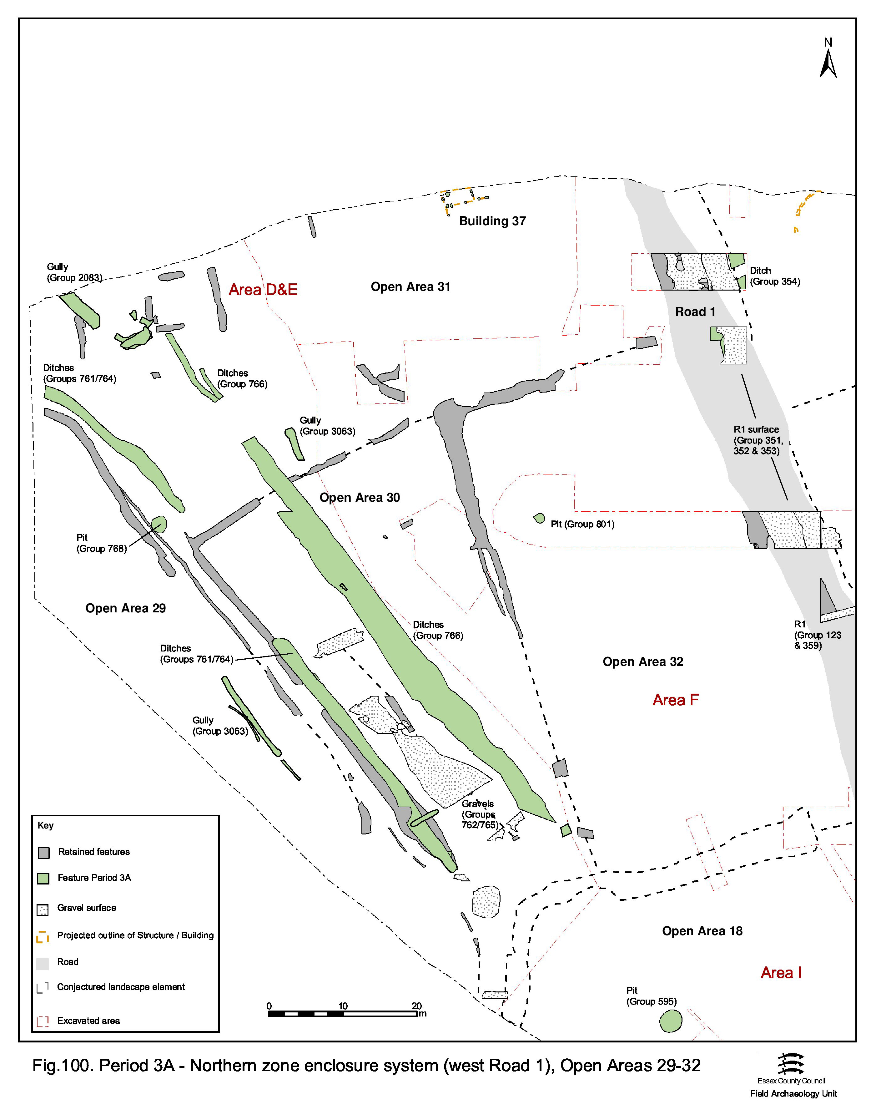
Only the eastern edge of this enclosure interior is exposed within the extent of excavation (Figure 100). Building 15 continues to occupy the southern end of the enclosure in the early part of Period 3, perhaps with some of the posited fences still standing in association. It is notable that the re-established boundary ditch 25028 runs up to, and respects, these structures as had its Period 2B forerunner 25017. Elsewhere, OA29 contains no dated Period 3A remains, from which it must be tentatively concluded that it continues to function as a field or paddock, as is judged to be the case in Period 2B. The only recorded, but undated, feature that hints at something of a subdivision within it is a short length of gully/ditch 25009 (Group 3063), which conforms to the prevailing NW-SE alignment of ES9. Solitary pit 9218 (Group 768) may be deliberately positioned on the eastern boundary, alongside the terminal of ditch 25018. Its pottery assemblage (KPG16) dates to c. AD 55-65.
On the strength of the excavated evidence, these enclosures appear to be largely unoccupied - if indeed still extant, particularly in the case of OA30 (Figure 100). It is conceded that some of the broadly dated early Roman pits might be present now. Vestiges of an apparent building (Building 37, Group 786) are identified in OA31, on the very edge of excavation, but being of only general early Roman date could just as easily have been constructed in Period 3B. The Period 2B sub-enclosures, which formerly occupy the west end of OA31, would appear to pass out of use by or during the later 1st century. Pit 10355 (Group 801) is the only mid-1st century Roman example occupying OA32.
It is possible that a tangible and formal southern limit to the northern enclosure system is imposed for the first time in this period, with ditches 25034 and 25035 (Groups 769, 770) possibly defining the northern limit of the settlement's core (i.e. the Central Zone) with post-hole 9606 (Group 771) possibly hinting at the presence of a gateway structure in their gap. The creation of this boundary effectively cuts off the Period 3A surfaced trackway, preventing direct access into the central zone. However, given the continued existence of a narrow access, it is probable that it continues to function as something of a route for a time before its western boundary (i.e. ditch 25028, and maybe 25018) passes out of use. With the presumed continuance of ditch 25026, this effectively results in the eastward shift of the main north-south axis of this enclosure system. Although now enlarged eastwards and northwards, OA29 is subsequently divided by ditch 25029 (Group 763) into two new enclosures - hereafter termed OA47 and OA48. Given its proportions, 25029 may represent a relatively minor division with a point of access between the newly created land units positioned between it and major boundary 25026. It is speculated that 25026 extends southward as far as the new southern limit of the northern enclosures, probably merging with 25035 as it extends eastward to Road 1.
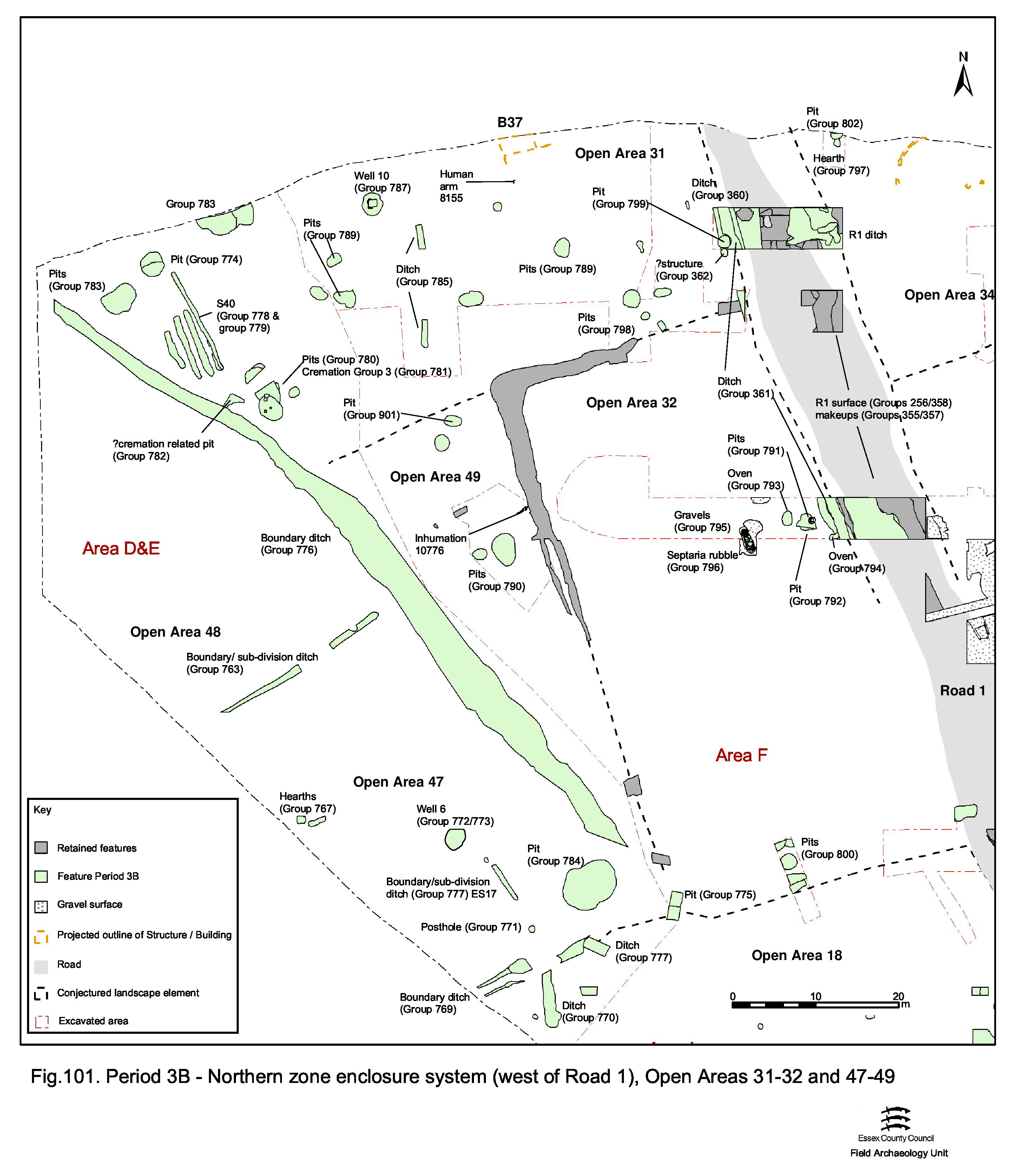
Later in Period 3B a number of minor changes take place. Ditch 25006/25026 is directly replaced by another, 25021 (Group 776), which is cut along the western edge of the earlier boundary - except at its northern end where it veers off to the north-west, somewhat reminiscent of its other predecessor ditch 25018. It is conjectured that this replacement ditch extends south as far as the ES9 southern boundary. While southern boundary ditch 25034 may continue into this phase, the less substantial 25035 is itself replaced by bigger ditch 25015 (Group 777), offset further east to widen the hitherto narrow access point between enclosures and between the Central and Northern settlement zones. This ditch likely extends eastwards to the edge of Road 1, seemingly attenuating the Central/North zone divide - or else signalling the changing function/importance of Open Area 18 at this time. The impact of the imposition of adjusted boundary ditch 25021 upon ES9 is perhaps relatively minor. OA31 is enlarged at the expense of OA47, but it is difficult to ascertain whether or not some of the remaining enclosures are amalgamated into larger entities.
Although Period 2B Building 15 almost certainly no longer exists beyond the end of the 1st century, timber-lined well 9421 (Group 772) is cut through the fills of the former trackway ditch 25028 and suggests that there is still occupation in the vicinity ( Figure 101). There are, however, no closely dated structural features and few pits to support this view. However, it is worthwhile noting the presence of non sub-phased Period 3 remains such as storage jar oven 9573 (close to the well and also cut into defunct ditch 25028), hearths 9369 and 9404, and another storage jar oven 9506 - the latter albeit technically to the south of the ES9 boundary in the corner of an (unnumbered) Central Zone enclosure to the west of OA18 (all Group 767). Elsewhere in the settlement, storage jar ovens can be demonstrated to occur in Period 3B/early 2nd-century contexts, so these examples may be cautiously included here.
Unlike OA31, OA47 is not affected by the further enclosure system changes. Well 9421 (Group 773) passes out of use, first accumulating a range of items that may suggest structured deposition and then a sequence of fills that include wooden furniture fitting/embellishment SF6615 (Figure 102) among large quantities of more mundane refuse and debris. Final deposition may continue into the 3rd century (Period 4). A nearby slot, 25011 (Group 3063), may relate in some way to its secondary use as a rubbish pit. Otherwise, only a single mid-2nd century pit 9750 (Group 784) is recognised to occupy its interior, discretely placed in its south-east corner.
In essence the northern half of former OA29, this newly created enclosure appears to be devoid of activity throughout the whole of Period 3 (Figure 101). A function as a paddock or in-field can perhaps be assumed.
Open Area 30 is effectively reduced in area in Period 3A, being significantly encroached upon by OAs 47 and 48 and their eastern boundary 25026 (Figure 101). Accepting its continued functioning as a distinct land unit, now termed OA49, this narrow triangular tract contains no definite features, though there are a few broadly early Roman pits (Group 780) in a central position that could be contemporary. The sharply narrowing southern end of the enclosure, and the presumed merging of its boundaries into the southern boundary 25035, precludes this open space from acting as a thoroughfare between OAs 47/48 and 32.
Later in Period 3B a small quantity of pits (Groups 790, 901) are the only occupying features, among which a trend of mid-Roman period reuse is notable.
Open Area 31 is presumed to remain little altered in Period 3B, being only slightly encroached upon by the shifting boundary 25026 along its western side (Figure 101). A scatter of pits (Groups 783, 785, 789, 790) of broadly Period 3 date is located within its interior. Pit 9044 (Group 774) is positioned almost immediately in front of the point of access through boundary ditch 25006/25026 and may indicate that this gap is short-lived. Further Period 3B pits are located in the south-east corner (Group 798). While activity may well relate to marginal land-use alongside the watercourse, Building 37 is likely to occupy the enclosure during this period, perhaps surviving long enough to be associated with Period 3C subdividing ditch 25037 and possibly with well 8188.
The westward divergence of the northern end of ditch 25021 from the former enclosure boundary has the effect of enlarging the interior of OA31. A small, triangular 'extra space' (formerly part of OA48) is created which is quickly filled by a series of discrete features that serve to signal a distinct change in land-use, at least at this specific location.
The majority of this new space is taken up by a series of closely spaced parallel slots - Structure 40 (Groups 778, 779) - for which a function is unclear, but may be of a horticultural nature. To their immediate north and south are substantial pits (Groups 783, 780). Of these, re-cut pit 9630/9391/9663 subsequently has a small group of cremation burials (Group 781) inserted into its top. Also to the south of the horticultural slots, an odd triangular-shaped pit 9366 (Group 782) lies alongside the burials and may be related to them. Other late Period 3B pits (Groups 783, 901) occur sporadically across this western part of OA31 and some of the generally dated Period 3 pits (Group 789) could well belong to this phase of activity. While it cannot be confirmed that Building 37 endures as late as the mid-2nd century, the imposition of well 8188 (Group 787) on the opposite side of subdividing ditch 25037 suggests continuing occupation - though admittedly this could equally be used for watering livestock.
Although the interior of OA32 is not widely sampled, occupation is particularly evident in close proximity to Road 1 (Figure 101). This rectangular plot is presumed to continue into the early Roman period, although it remains possible that by Period 3B it has merged with the adjacent OA49. Storage jar ovens (Groups 793, 794), fragments of gravel surfaces (Group 795) and rubbish pits (Groups 791, 792) attest to primarily domestic activity, at least along the road frontage. Further pits (Group 800) are present in its south, alongside a conjectured continuation of the ES9 boundary 25035. All are broadly early Roman and continuity of OA32's land-use either side of the Conquest is therefore postulated.
The only identified mid-2nd century activity within this enclosure is along its frontage with Road 1. Here linear arrangements of septaria rubble dumps 10266 and 10278 (Group 796) run parallel to the road in short, shallow slots. Some of the other pits in this vicinity could extend this late.
In contrast to the enclosures on the opposite side of Road 1, the absence of successive and inter-cutting boundary replacements makes it impossible to define enclosure change and development through Period 3 across this area. While it is perhaps possible that this part of the Northern Zone is now occupied by larger and fewer enclosures, in the absence of new boundaries on differing alignments it is tentatively assumed that those defining OAs 33-36 in Period 2B are perpetuated in some form. The limited and widely spreaded excavated features across this part of the Northern Zone (Excavation Areas G and R), along with the poor clarity of dating of early Roman remains occupying its enclosures, precludes the meaningful division of activity into sub-periods.
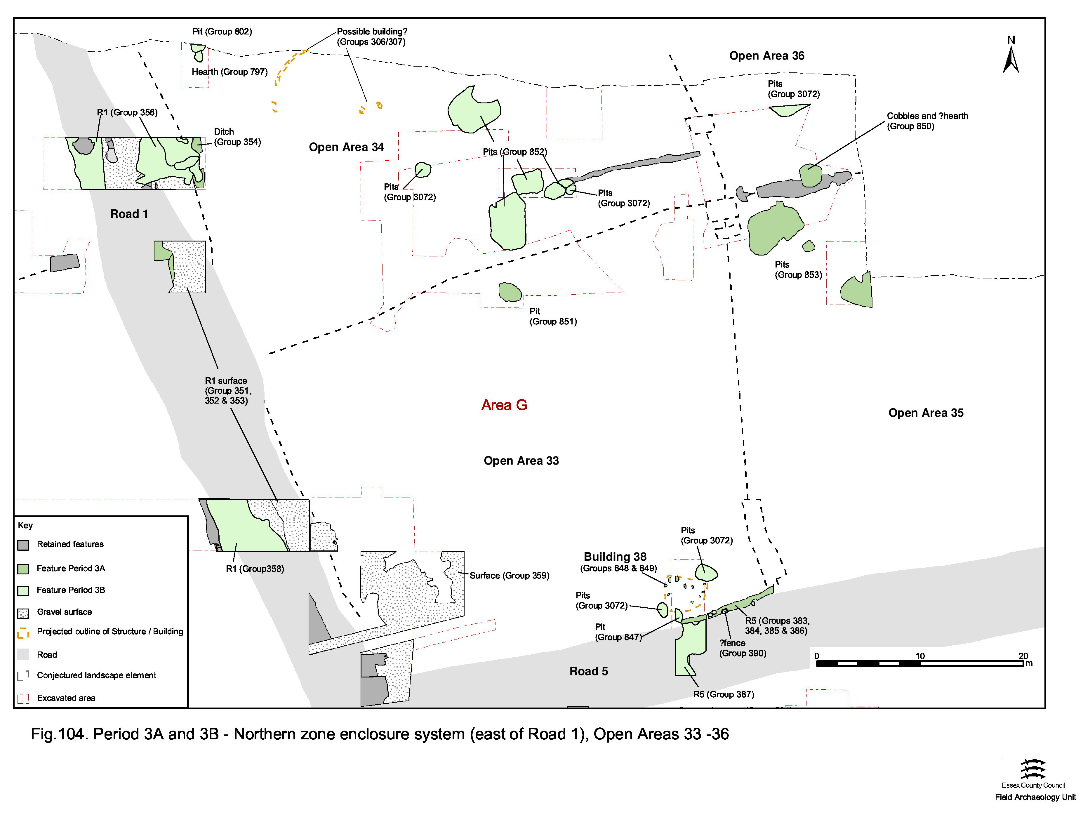
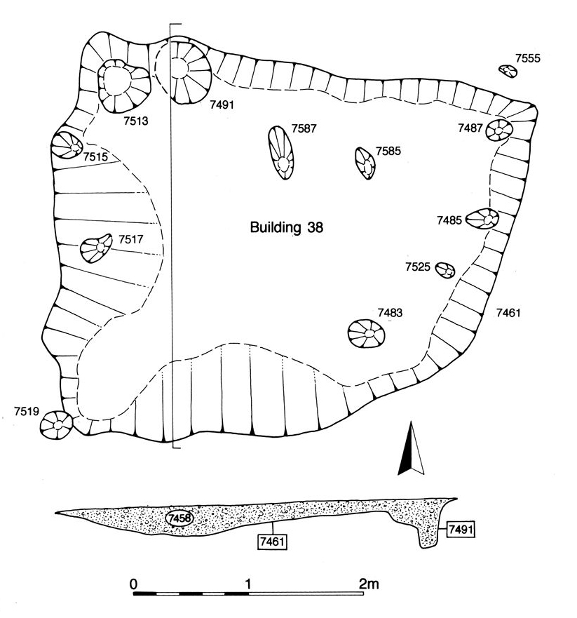
It is likely that much, if not all, of the interior of OA33 is surfaced with gravel (Group 359) during Period 3 (Figure 104). Apparently laid as an extension of the contemporary Road 1/3 resurfacing, it extends away from the road junction, though perhaps petering out toward the northern and eastern enclosure margins. Where investigated, it is not encroached upon until at least the mid-2nd century. The south-east corner of the enclosure, alongside Road 5, is occupied by sunken-floored Building 38 (Groups 848, 849) (Figure 105). The few pits of early Roman date (Groups 847, 851) are thought to indicate that such disposal activity is restricted to the margins and generally away from major road frontages.
Excavated evidence of early Roman period activity in OAs 34 and 35 is restricted only to a few pits (Groups 802, 852, 853) and a hearth (Group 797) (Figure 104). The more substantial pits contained larger and more varied artefact assemblages that presumably hint at a generally higher level of activity/occupation within these Northern Zone enclosures than is otherwise indicated.
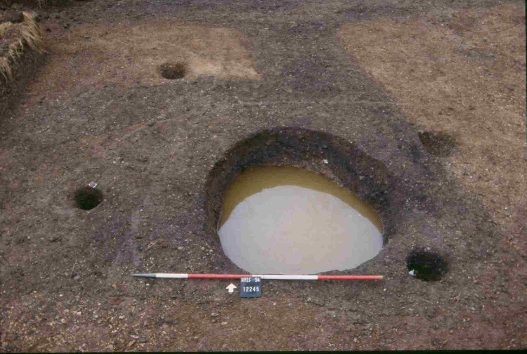
Similar to OAs 34 and 35, the single pit 7341 and gravel surface 7059 (Groups 850, 3072) identified in the south-west corner of the enclosure gives little useful insight into function and character. However, its posited north-east corner, where investigated within Excavation Area R, contains features indicative of Period 3 occupation and land management that extend back to the edge of the watercourse (Figure 104). Well 12245 (Group 955) (Figure 106), with its possible two phases of housing structure (Groups 956, 962), is accompanied by a scatter of pits (Group 957) of late 1st to early 2nd century date. Some subdivision of the enclosure is also suggested by short fence alignments (Group 963). A sequence of ditches, 12309, 12291, 12236 and 12299 (Groups 958-961) running parallel with the watercourse mark the northern extent of this occupation activity and perhaps serve to prevent flooding of the enclosures that back on to it. These ditches display a series of southward shifts that may indicate progressive incursion of water brought about by the shifting and building up of the north bank of the watercourse channel (see below).
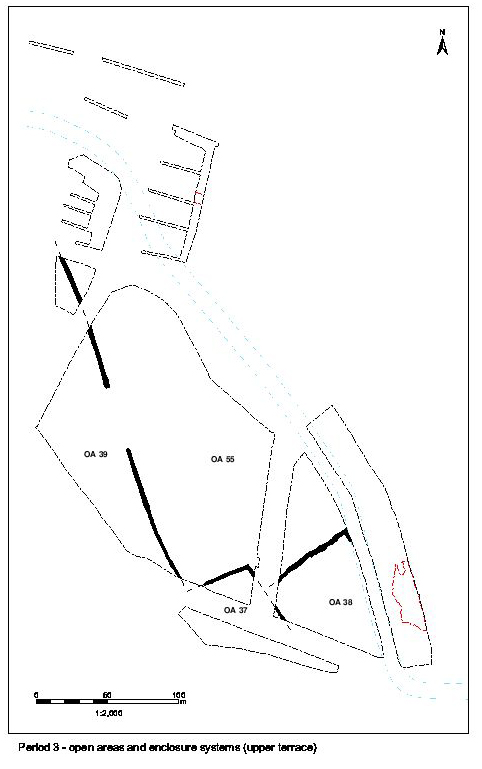
The Late Iron Age field boundaries of that part of the Northern Hinterland Zone to the west of the projected course of Road 1 (Figure 72) seem to continue to function throughout much of the early Roman period, with little sign of significant change until relatively late in the period. This field system can be conjectured to be extensive, as hinted at by early Roman ditch 25207 located during outlying evaluation trenching at the far north end of the site, near Langford Road. All of the major Period 2B ditches are actively maintained during the late 1st and early 2nd centuries, as evidenced by episodes of re-cutting, with only a slight modification, amounting to a simplification, of their layout at the junction of OAs 37, 38, 39 and 40. While some phasing of this enclosure boundary development can be identified between the late 1st/early 2nd and mid-2nd centuries, this cannot be correlated with any confidence with landscape change in the Northern Zone on the terrace below.
It is not until the very end of the period, around the mid-2nd century onwards, that any significant changes to the landscape are made. Boundary ditch 25188 is re-established by re-cuts 25273 and 25274 (Group 890) and 25199 by re-cuts 25103 and 25105 (Group 892). More significantly, the latter boundary is modified by the creation of a large entrance gap marked by the termini of its re-cuts. This seems to mark the onset of a number of further developments and modifications to the Northern Hinterland, which are described in Period 4.
Further east, immediately north of the watercourse, the results of limited investigation within Excavation Area R (north) hint at a more complex process of reclamation and consolidation resulting in a distinct change of use when, at least in part, it is reoccupied by cemetery activity. For ease of reference, this land-use is regarded to occupy OA58, a nominal enclosure alongside the watercourse.
The peripheral nature of OAs 37 and 38, as previously described for Period 2B, persists in Period 3 (Figure 107). Straddling the step between the upper and lower gravel terraces, these land units continue to display a distinct character of their own - being neither distinctly agricultural nor occupational in nature. However, while pitting (Group 889, 992), presumably for the purposes of disposal, remains a feature of OA37, burial now also features in adjacent OA38. A small cluster of five cremation burials is located in the corner of the field, with a further outlying example to their south-east (Group 893). Although their presence in the Northern Hinterland can perhaps be construed as a tentative strand of continuity of land-use from the Late Iron Age, their subtly differing location within its fields might indicate that it is by this time less structured, and probably represents the final stage of this traditional practice during the middle to later 1st century AD.
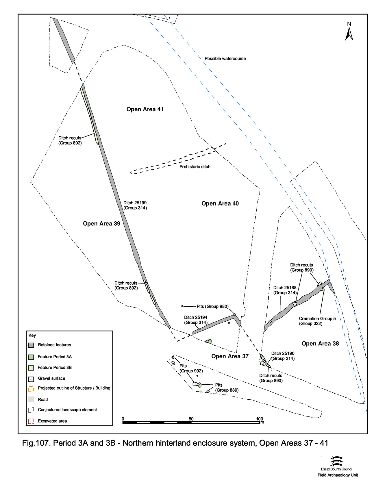
Most markedly, the functioning of OA39 as a pyre field clearly ceases, presumably on or shortly after the Conquest - indicating cultural or technological change that impacts upon mortuary/funerary practice (Vol. 1, Chapter 7). The interiors of these northernmost fields defined within the Northern Hinterland are virtually devoid of early Roman features and can therefore only be regarded as agricultural units at this time (Figure 107). The only activity within these enclosures is the digging of a few shallow pits (Group 980) in OA40.
As evidenced by the depositional sequence investigated in Excavation Area R, the ground surface immediately north of the watercourse is built up in an episode of concerted dumping of gravels and silts (Group 953) over an extensive area. This raises the sloping land-surface by as much as 1m alongside the river channel and seems to necessitate revetment of the northern edge of the watercourse. A number of posts preserved in the waterlogged silts (Group 954) are interpreted as the remains of such a revetment. This activity is further interpreted as part of a deliberate scheme to reclaim some of the marshy peripheries of its channel, regularise its course, create a more tangible river bank and perhaps increase its flow. Interestingly, there is no evidence of features subsequently cut into these dump deposits until the mid/later 2nd century, which may indicate this undertaking required a protracted period of time to accomplish.
Although reclaimed at some considerable effort, when subsequently reoccupied this location apparently retains its liminal status in relation to the early Roman settlement on the lower terrace and opposite side of the watercourse. Part of the north bank is used as the site of a small cremation cemetery. A tight cluster of eight, possibly nine, graves (Group 964) may constitute a small family burial ground, the use of which spans the mid-2nd to early 3rd centuries. These are the most richly furnished of any Roman graves found within the Elms Farm development and includes boxed or shuttered grave 12203, which includes seven ceramic vessels, a glass flask and a bead, fourteen burnt bone gaming counters and an iron hanging lamp complete with its hanger.
While the location of this cemetery north of the watercourse could be construed as indicating adherence to Roman laws regarding burial, it remains equally possible that these burials in fact are located within the rear of an unrecognised occupation plot that extends northwards from the river. More recent excavation along Crescent Road (Roy 2003), immediately north-west of Excavation Area R, has identified a strip plot occupying this vicinity during this period. Containing pits and an isolated further later 2nd-century cremation burial, it may be conjectured that this was indeed the rear of one of a number of strip plots backing onto the watercourse.
By Period 3, the easternmost investigated extent of the settlement can be viewed as the tail-end of the Central Zone. Development Area A4 contains the convergence of Roads 3/4 and 5 and so could technically also include parts of the Northern and Southern settlement zones either side. However, given the increasingly intangible and track-like nature of the roads as they extend eastwards from the settlement core, and the demise of the Period 2B ditch along the north edge of converged Road/track 3/4, it seems reasonable to assume that such divisions become somewhat blurred this far out. Regarding this as the eastern hinterland, particularly given its separation from Areas A1/A2 by basically uninvestigated Area A3 would seem apposite. The previously-applied subdivisions of OAs 42, 43 and 44 are therefore abandoned. Two phases of early Roman buildings can perhaps be discerned, though it is not possible to associate other features of this period with one or the other with any confidence. Some attempt is made to distinguish between earlier and later Period 3 development in this part of the settlement.
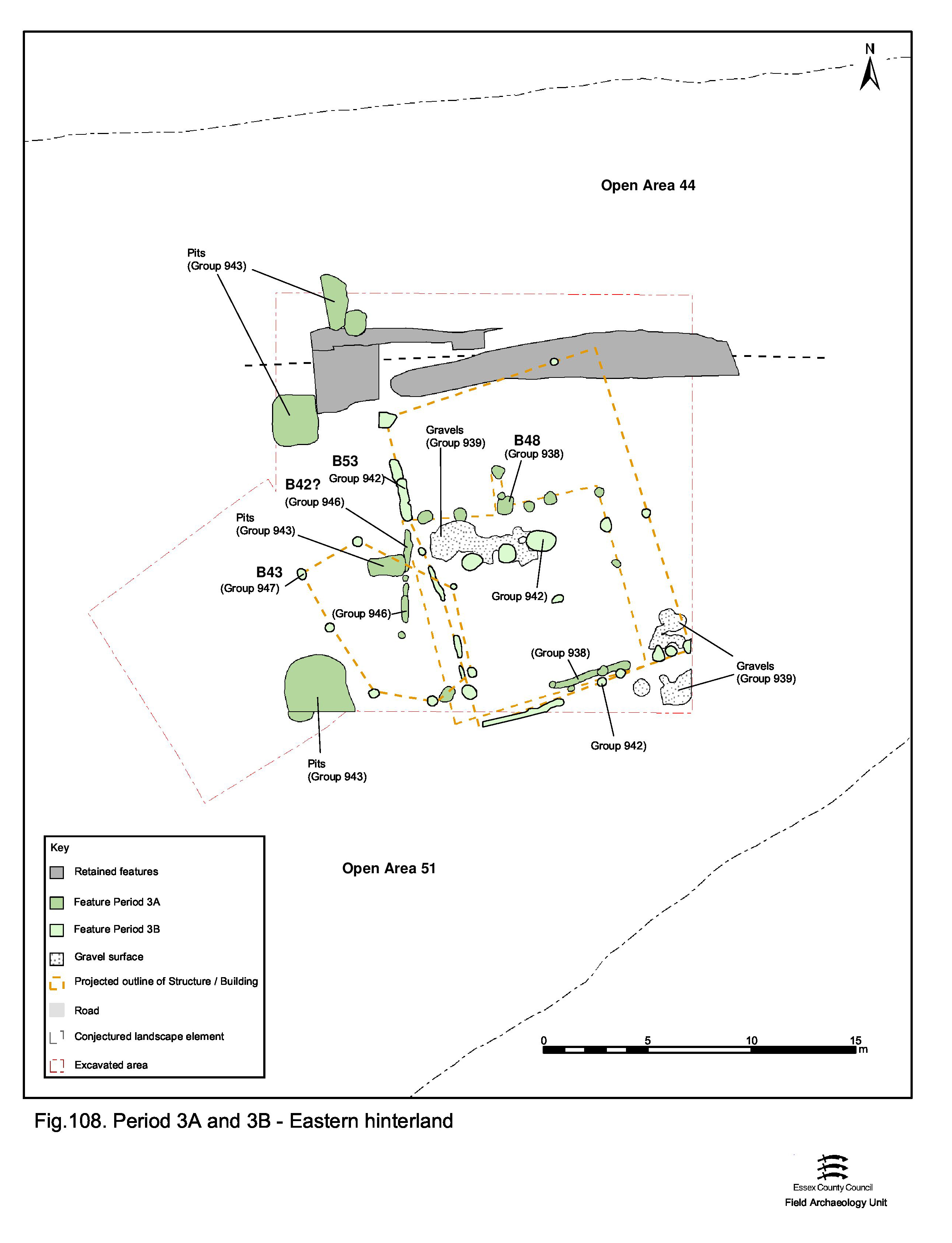
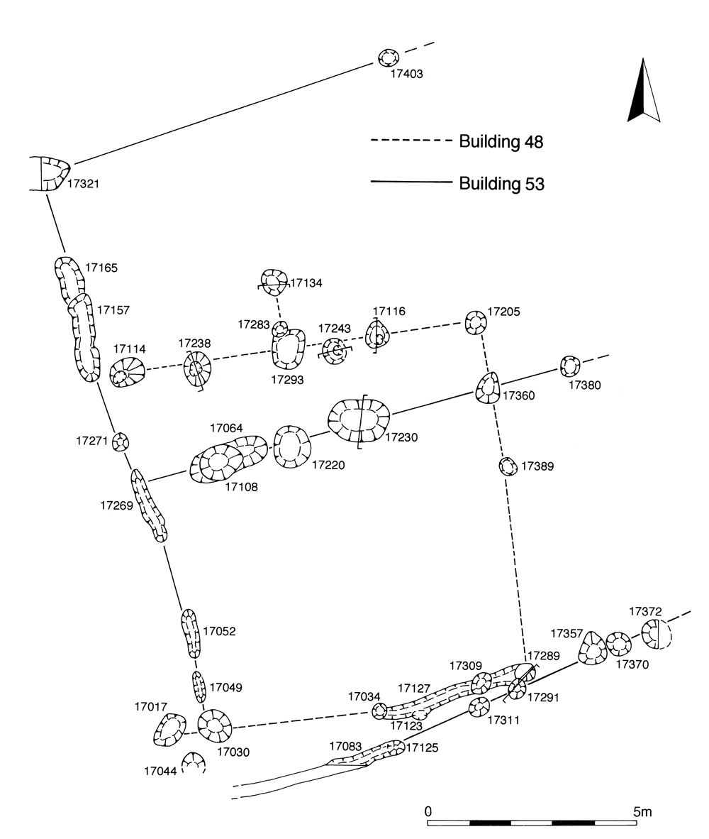
The earlier, mid- to late 1st century, activity suggests continuity from Period 2B (Figure 108). The two major east-to-west ditch lines remain open, accumulating material though probably not actually being re-cut, perhaps until the end of the 1st century. Significant change is manifest by the construction of Building 48 (Group 938) over northern roadside ditch 25179. Although somewhat conjectural, this rectilinear post- and slot-built structure (Figure 109) seems to be aligned on the road/track itself and may hint at its continuance immediately alongside.
Fragmentary and poorly understood gravel surfaces (Group 939) overlie those of Period 2B. Although they are too patchy to be reliably regarded as a single surfacing episode from which sub-phasing can be deduced, some may at least constitute flooring within Building 48.
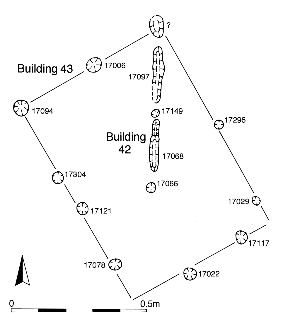
Even more tentative Building 42 (Group 946) is construed from the various post-holes and slots that are scattered across the investigated parts of Excavation Area Q (Figure 110). Perhaps constituting little more than a fence, this structure is speculated to be contemporary with Building 48.
Subsequently, Building 48 is evidently replaced by another rectilinear building of similar construction, Building 53 (Group 942) (Figure 109). This again fronts onto Road/track 3/4 and is perhaps built around the mid-2nd century. A patch of gravel surfacing seals a structural element of Building 48 and may be a remnant of flooring within its replacement.
Possible Building 43 (Group 947) (Figure 110), located to the west, does not share the alignment of the other structures, but could accompany Building 53.
The early Roman pits (Group 943) lie to the west of both Buildings 48 and 53. Generally located on or close to the defunct roadside ditch, they may perpetuate the boundary and be presumed to be associated with the buildings. At the very least, the presence of early Roman features at this location demonstrates that settlement activities are being carried out at some distance from the settlement core.
Internet Archaeology is an open access journal based in the Department of Archaeology, University of York. Except where otherwise noted, content from this work may be used under the terms of the Creative Commons Attribution 3.0 (CC BY) Unported licence, which permits unrestricted use, distribution, and reproduction in any medium, provided that attribution to the author(s), the title of the work, the Internet Archaeology journal and the relevant URL/DOI are given.
Terms and Conditions | Legal Statements | Privacy Policy | Cookies Policy | Citing Internet Archaeology
Internet Archaeology content is preserved for the long term with the Archaeology Data Service (ROR). Help sustain and support open access publication by donating to our Open Access Archaeology Fund.