The prevailing impression derived from Period 4 remains is of occupation activity contracting towards the settlement nucleus, which lies to the west of the temple complex, and that much of the area encompassed by the Elms Farm excavations is increasingly being given over to peripheral, perhaps purely agricultural, uses (Figure 134). Within this broad picture, however, some distinctions can be made. It is, for example, apparent that continuity is more manifest in those areas closest to the settlement focus. Thus, Open Area 23 (the temple precinct) and Open Areas 18, 19 and 28 seem to demonstrate least change from Period 3. Indeed, the continuing development of the temple complex is conspicuous against the general background of apparent contraction and change of use.
There is little sign of significant alteration to the layout of the Northern Zone, although occupation seems to be generally confined to the roadsides - itself perhaps a sign of settlement contraction, although its outlying parts are presumed to function as fields and paddocks.
It is possible that a major north-south aligned dividing line across the lower terrace is becoming apparent during Period 4. The cardinal feature of this alignment is the eastern boundary wall of the temple precinct. This alignment includes the eastern boundary of Open Area 28 and, less certainly, the possible eastern boundary of the adjacent plot (Open Area 33) within which Building 54 is set. Only within Open Area 19 are features on this alignment not readily apparent, but it is noticeable that both the Period 3 sub-enclosure ditch and Period 5 robbed wall line (Structure 44) do coincide with it. It may be that the eastern limit of the contracting settlement and the start of its agricultural hinterland is increasingly defined by this line.
Evidence of change and contraction is strongest in the Southern Zone where the long-standing regular roadside enclosure boundaries are superseded by ditch 25177. Only Open Area 28 and its occupying Building 39 survive this. Open Areas 24-27 are amalgamated, forming a single new entity - Open Area 50 - that is seemingly completely devoid of buildings and may constitute fields. Other activity, almost exclusively pitting, is concentrated in the western part of the southern zone, again closest to the perceived focus of settlement. The presence of manufacturing processes further east, primarily represented by two pottery kilns, almost certainly demonstrates that this part of the lower terrace is now increasingly peripheral to the main settlement focus to the west. By the early to mid-3rd century AD, Building 39 may be the most easterly building within the Southern Zone. The continued existence of Road 3 any further east than the eastern boundary of the temple precinct is unlikely, though its approximate route may be perpetuated by a track. In the Eastern Hinterland there is a complete absence of significant Period 4 activity and its distinction from the Southern Zone is probably not particularly meaningful by this time.
The Northern Hinterland and the eastern part of the Southern Zone display increasing similarities. Both contain kilns and crop-processing structures, large fields and animal pens, and both demonstrate that functions such as rubbish disposal become scarcer away from the settlement focus. Across the settlement in general, the quantity of pits reduces in Period 4 while the rubbish in them proliferates. At the same time, middening is more evident and the two phenomena may be linked and suggestive of a changing mid-Roman disposal practice.
That part of the Northern Hinterland to the north of the watercourse may, conversely, exhibit increased occupation. Strip plots are laid out along the upper terrace edge and the Period 3 cemetery is abandoned, its site being levelled and crossed by a wood-lined channel - possibly a mill leat or else drainage from a major building such as a bath-house.
Given the continuing development of the temple complex against the backdrop of contraction and/or apparent decline of outlying settlement areas, it is speculated that the religious focus is increasingly the raison d'etre of the settlement. However, settlement shift or emergence of poly-focal occupation remains a possibility.
While Period 4 covers the later 2nd to mid-3rd centuries AD, a certain degree of overlap with Periods 3 and 5 is inevitable in terms of the features and deposits identified. Definition of distinct sub-phases within this period is difficult, except where clear stratigraphic relationships occur between key landscape features. However, it is extremely difficult to extend this to the remainder of the Period 4 remains, which are generally only broadly dated and have no direct relationship or patterning. Consequently, a rather loose 'earlier/later' distinction is made where possible but should generally be regarded as being fairly vague. As ever, the identification of sub-phasing among the pits is particularly problematic and has generally not been attempted.
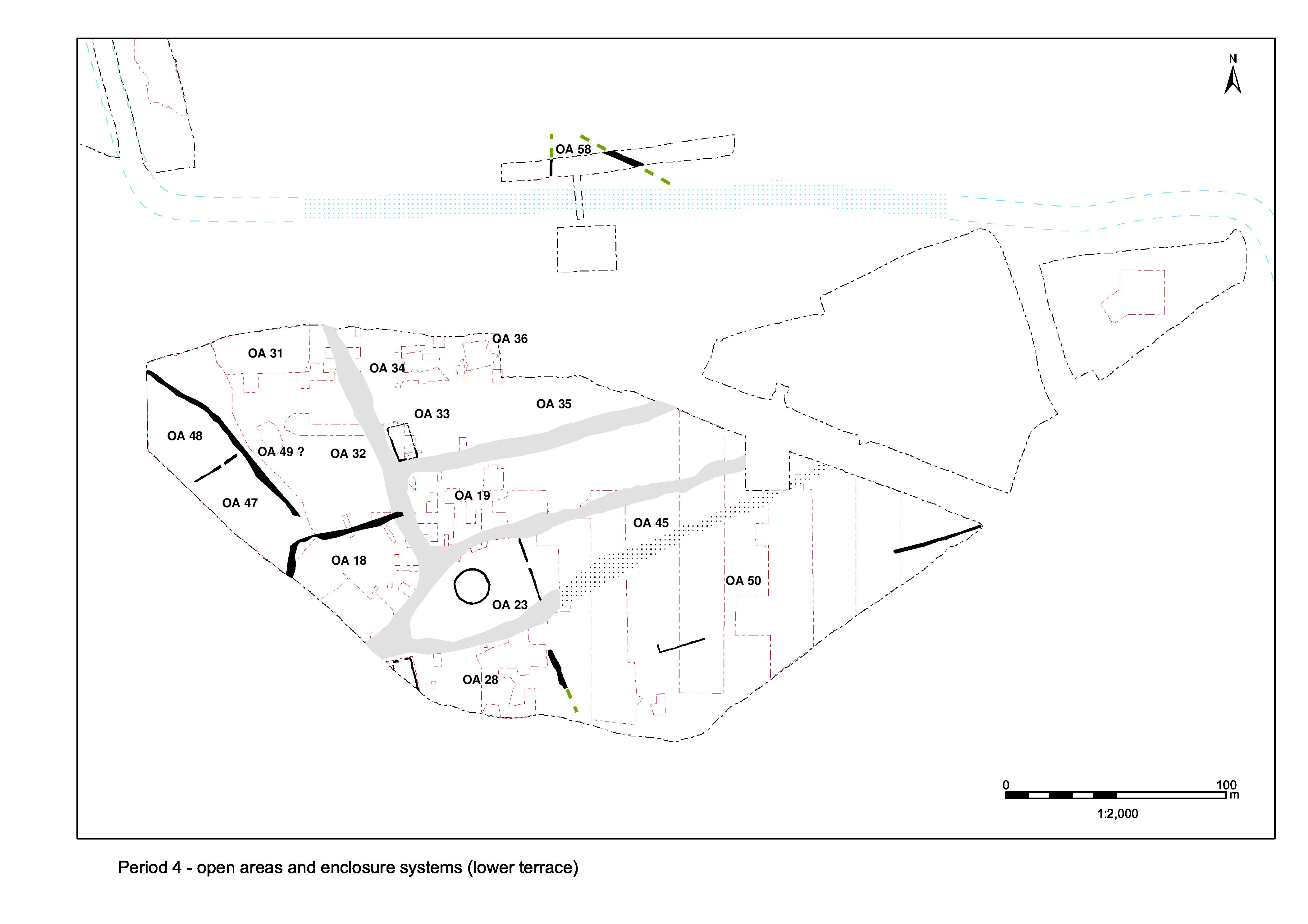
By and large, the settlement layout of roads and enclosure systems imposed in Period 2B, and retained/modified in Period 3, endures into Period 4 (Figures 135 and 136). However, it is apparent that more significant change, amounting to settlement contraction and perhaps decline, is taking place within this increasingly neglected (even discarded?) infrastructure. As for Period 3, description of enduring enclosure systems is minimal unless where identified to be either significantly modified, redefined or rendered defunct during the mid-Roman period. Discussion of the road infrastructure is particularly summary and largely concentrates upon the evidence for its neglect and decay.
Period 4 sees some continued resurfacing and maintenance of Roads 1, 2 and 4. However, this activity is less concerted and the status of Roads 3 and 5 becomes increasing ambivalent. It is likely that this is the last period to see active upkeep of these infrastructure elements.
The resurfacing of Road 1 becomes less frequent and expansive in Period 4. However, it is clear that earlier surfaces survive and remain in use as a thoroughfare.
The Period 3 surfaces of Road 1 appear to remain in use into Period 4, with later 2nd to 3rd century use-accumulations building up on them, particularly to the north of the Road 1/5 junction. Here, the only widespread resurfacing of Road 1 that can clearly be attributed to Period 4 is limited to a single episode (layer 10281 Group 815) running north from its junction with Road 4 (though it is extremely likely that a less well-dated resurfacing further south (10267 Group 815) is broadly equivalent). In contrast with earlier phases of Road 1, these later surfaces and make-ups contain varied finds assemblages that include quantities of metalwork, particularly iron nails, and tile. Washed and silty deposits accumulate along the roadside and seem to mark a break with Period 3, possibly indicating that the roads are now less well maintained. Just to the north of its junction with Road 5, Road 1 is temporarily encroached upon by Building 54, though apparently reclaimed on the structure's demise, most likely in the early/mid-3rd century. Here, a more coherent sequence of compacted gravel deposits (Groups 862, 866) on make-ups (Group 861) seem to represent a single continuous surface that widens Road 1 eastwards and seals the remains of the western wall of Building 54.
Where Roads 1 and 5 meet, the evidence is very sketchy though the recorded sequence (Group 540) may include as many as seven episodes of surfacing. The sparse dating suggests that at least some of this resurfacing is late 2nd or early 3rd century AD in date. Toward the southern end of Road 1, gravel surface 13394 (Group 633) and overlying silt accumulation 13419 (Group 634) probably date to this period, though being at the top of the sequence it is difficult to be certain of this.
While the Period 3 western roadside ditch may endure, that to the east is overlain by the Period 4 road surface and is evidently not replaced.
The presence of surface wear and further localised repairs to Road 1 would seem to indicate the continued use of the road as a principal thoroughfare throughout the 3rd century. Further consolidation (Group 542) and resurfacing (Group 633) is required following subsidence caused by the underlying Period 2 waterhole. Dirty gravels (Groups 813, 903) are the latest deposits in the sequence at the north end of Road 1, and the most abundant in artefacts - a large amount of 3rd century pottery and tile being present. It is possible that the tile is a deliberate inclusion in an ad hoc attempt to maintain the road. The presence of an iron split-pin (SF2194), perhaps deriving from a cart using the road, further suggests continuing use as a thoroughfare. Elongated ruts filled with gravelly silt (Groups 812, 817) are apparent on the road surface, along with likely further surface repairs (Groups 816, 818). Roadside accumulation (Groups 819, 820, 538), noted at the south-east corner of the Road 5 junction and down the west side of Road 1, suggests increasing accumulation of road-wash and rubbish-rich silts and lessening maintenance as Period 4 progresses.
The existence of further surfacing of Road 2 is only identified at its southern exposed extent, where a final gravel deposit 18324 (Group 635) overlies an early 2nd century surface and subsequent silt build-up of uncertain. though probably protracted. duration (Period 3 Groups 367, 368). While this latest surface could perhaps belong in late Period 3, the continuation of Road 2 is not in doubt and its inclusion in Period 4 accords with resurfacing carried out to Roads 1 and 4 during this period. Road 2 continues to be marked by roadside boundary fences either side, on the OAs 18 and 23 frontages.
Unlike parallel Roads 4 and 5, the western end of Road 3, south of the temple precinct (OA23), is apparently not resurfaced during Period 4, but the continued presence of the substantial Period 3B fenceline (Structure 38) along the south side of the precinct suggests that this part of the road at least remains in use.
It seems likely that alongside the temple Road 3 may be little more than a poorly defined track that receives little maintenance beyond the earlier 2nd century. Road edge feature 5093 (Group 433) may either be a hollow that forms on the edge of the extant road surface or a fusion of several smaller features. However, its finds assemblage indicates that it accumulates temple-derived debris rather than simple road-use deposits.
Further east, Road/track 3 continues to be encroached upon with pit cluster 21085 et al. (Group 711) and pit 11304 (Group 674) being positioned upon its line.
In contrast to Road 3, more attention is given to Road 4, which is twice resurfaced at its west end, alongside the temple precinct. The first comprises gravel deposits (Groups 413, 414, 511) that form a concave road surface up to 0.15m thick laid upon make-up layers. Patchy gravels on the surface of the road probably represent later repairs. This surfacing episode seems to involve a slight narrowing or northward shift compared to earlier (and later) surfaces. Road 4 is finally resurfaced in the early to mid-3rd century. Laid partly upon the earlier gravel road surface and partly upon additional make-up layers, this surface (Group 417) appears to constitute the northward widening of the road to at least 7m, returning it to its original Period 2 dimensions.
The continued existence of the road is also attested to by the fact that the boundary between it and the northern side of the temple precinct undergoes two separate phases of modification during Period 4.
The excavated evidence for resurfacing of Road 5 is confined to its western end. The later Road 5 surfaces are badly degraded but sufficient finds are present to define a 3rd century date for the latest layers recovered. One key indicator for the continued use of the road throughout Period 4 is that a ditch, which most probably originates as the northern Road 5 side-ditch, is present in Periods 5 and 6.
Road 5 receives its fourth gravel resurfacing (Group 541), a worn surface comprising poorly graded and compacted stones, during this period. This is the uppermost surviving road surface, perhaps suggesting that little maintenance is undertaken beyond the early/mid-3rd century AD. The pottery provides a mid-2nd to mid-3rd century date for its deposition.
It is unclear quite where the southern edge of Road 5 lies during this period. Two successive ditches (25259 Group 539 then 25115 Group 564) deviate southwards from the previous road edge and inter-relate with the complex sequence of gravel resurfacing within the interior of Open Area 19. Whether these features demonstrate a genuine widening of the road at this point or are in some way related to an entrance from the road into the interior of Open Area 19 is undemonstrated.
Ditch 25259 (Group 539) flanks the south side of Road 5 and terminates at the junction with Road 1. The ditch is, however, offset by some 3m from the road edge. Traced for a distance of 41m, it clearly extends further eastward. Its fills date principally to the late 2nd and early 3rd centuries AD, but in places continue to accumulate material into the second half of the 3rd century AD. The ditch cuts the gravel resurfacing (Groups 515/537) of the OA19 interior (see below).
Ditch 25115 (Group 564), which post-dates later Period 4 surfacing (Group 547) within OA19, is clearly a replacement of ditch 25259, whose line it closely reproduces, deviating only as it reaches the Road 1/5 junction. At least one episode of re-cutting is apparent and it is likely that the ditch continues to function, or at least to accumulate material, into the 4th century AD. A further ditch segment (6313 Group 4001) may in part represent the westward continuation of 25115.
The Central Zone displays a high degree of essential continuity from the early Roman period, with the road infrastructure continuing to provide its principal subdivisions (Figure 135).
Although the formal demarcation of some of the temple precinct boundaries is first apparent in Period 3 - in particular the creation of a substantial, possibly monumental, eastern front 'wall' (Structure 39, Group 403) - further substantiation of the boundaries of this sacred space is carried out in the mid-Roman period (Figure 147). The Period 3B boundary fence along the southern side of the precinct (Structure 38) is retained, but, by Period 4, there is also now a corresponding fence - Structure 45 - along the northern and western boundary of the precinct, running alongside Roads 2 and 4. It is quite possible that this perpetuates the line of an earlier fence, but Structure 45 represents the first coherent evidence of a boundary to have survived at this roadside location. Manifest as a shallow slot (Group 418), frequently truncated by later roadside pits and ditches, it can be traced for a distance of c. 58m. A number of post-holes within the slot suggest that it marks the foundation of a fenceline forming a continuous boundary around the northern side of OA23. Its relationship with the precinct east wall (Structure 39) is undetermined. Small amounts of pottery suggest that the structure dates to the early/mid-3rd century AD.
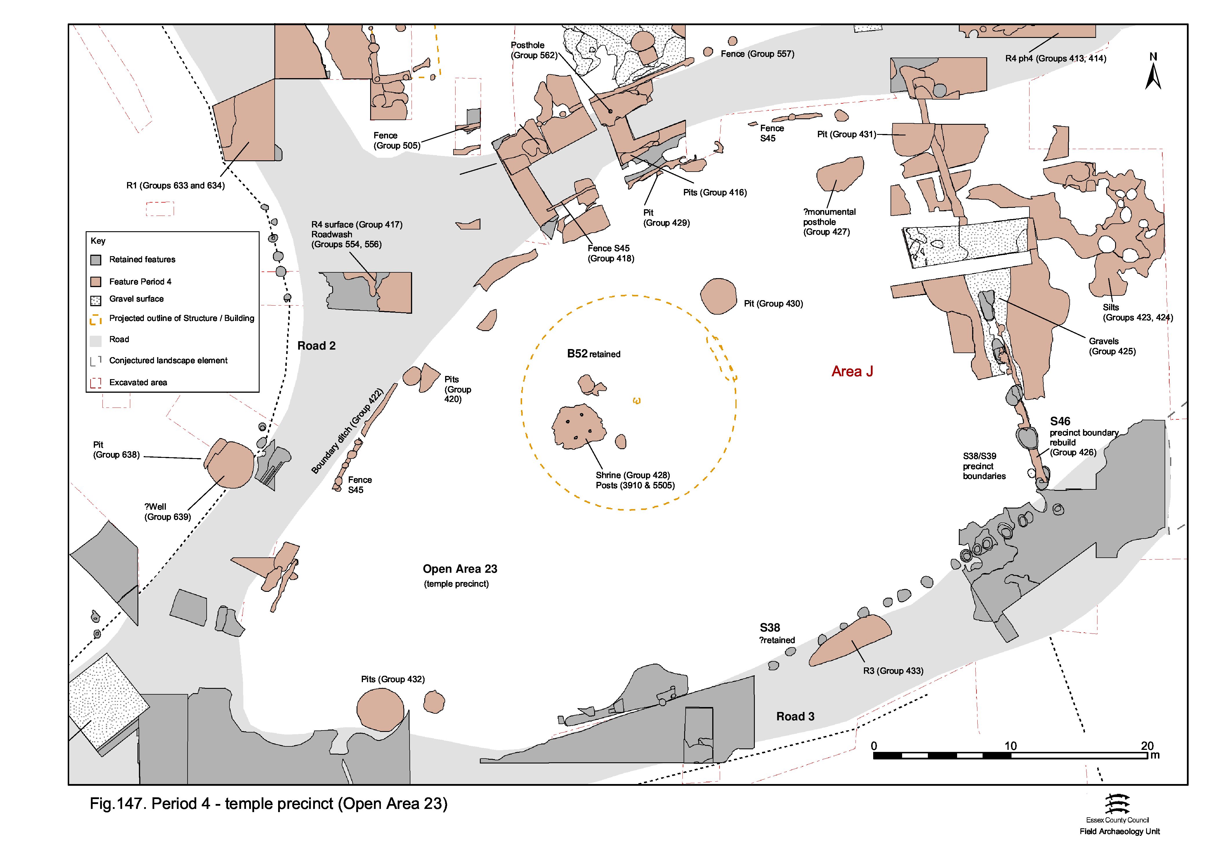
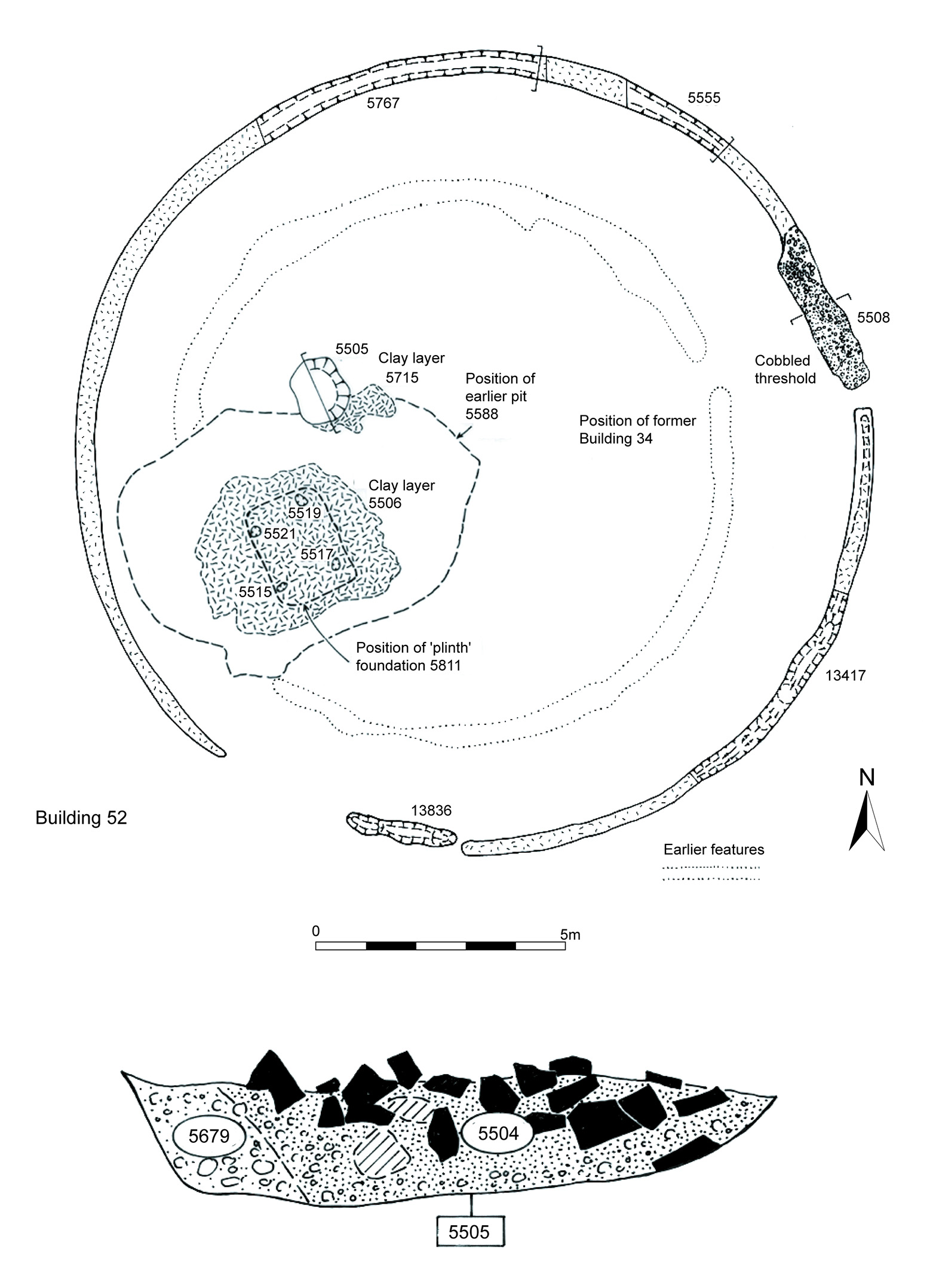
The circular temple itself (Building 52), which had been constructed within the precinct in the early to mid-2nd century AD (Period 3B), remains in use throughout Period 4 (Figure 79). Some changes are made, however, to its internal arrangements. The mortared plinth (Group 407 Period 3B) is demolished down to below floor level and its site levelled (5506/13428 Group 428) in preparation for the imposition of rectangular, post-built Structure 47 (5515, 5517, 5519, 5521 Group 428). Structure 47 measures 1.2m by 1.4m and is set precisely over the site of the plinth remains (Figure 148). A subsidiary or related element of Structure 47 comprises an almost square, shallow cut (5505 Group 428) set a little to the north-east. It is packed with tile and stone rubble to form a probable post-pad for a timber upright. A matching feature (3910) was observed during the trial-trench phase of site investigation. The two post-settings may define the position of a canopy set over a replacement shrine defined by the four post-holes. The interior of the temple remains otherwise unoccupied.
While early Roman pitting is almost exclusively limited to a single location to one side of the temple doorway, depositional activity within the temple precinct is changing by the beginning of the 3rd century (Figure 147). Pit 5145 (Group 430), although technically dated as a mid-Roman feature, is clearly the final component of the temple entrance pit complex and, as with the earlier pits within the cluster, ritual deposition is evident within its contents, comprising an unusually large quantity of oyster shell (4kg), mature sheep and chicken remains, a stylus and iron door hinge base (SF563). Thereafter, pits are located towards the peripheries of OA23, particularly that of its northern boundary along Roads 2 and 4. Some of these pits may co-exist with the northern boundary fence (Structure 45), others cut its replacement ditch, indicating a relatively protracted episode of deposition. Sizeable, elongated, shallow pits (Groups 416, 420) lie along the edge of Road 4. Tesserae, along with quantities of tile, are present in their fills and the Group 420 pits also contain chicken bones, oyster shell and a small range of other artefacts (not too dissimilar from pit 5145) that may constitute deliberate deposits or else discarded debris from devotional activities.
The northern precinct boundary fence alongside Roads 1 and 4 is replaced or perhaps supplemented, later in Period 4, by ditch 25070 (Group 422) (Figure 147). Like the pits that occur alongside, the ditch contains a number of artefacts that may be deemed to have religious or votive implications/connotations; in addition to oyster shell, a coin (SF2090), a copper-alloy letter 'T' (SF2091) and a key (SF3556) all derive from it. Small pit 5245 (Group 429) near the ditch contains a copper-alloy ring (SF1292).
The wooden screen wall (Structure 39 Period 3B) forming the eastern precinct boundary is, in the late 2nd or early 3rd century AD, removed and replaced by a new wall (Structure 46, Group 426), on exactly the same line, set on a flint, tile and septaria rubble footing (Figure 137). The dating of this event is derived from the backfills of the Structure 39 post-holes; the construction of Structure 46 is not in itself closely dated, but it is assumed to have been an immediate replacement. The new wall is c. 31m long, spanning the distance between Roads 3 and 4, with a 3.1m-wide gap defining the position of the principal entrance into the precinct. This entrance is aligned with that of Building 52 and consequently is not precisely halfway along the length of the eastern boundary but offset slightly to the north. The nature of the superstructure of Structure 46 is unknown, but it is likely, judging by the relative slightness of the footings, to be wooden.
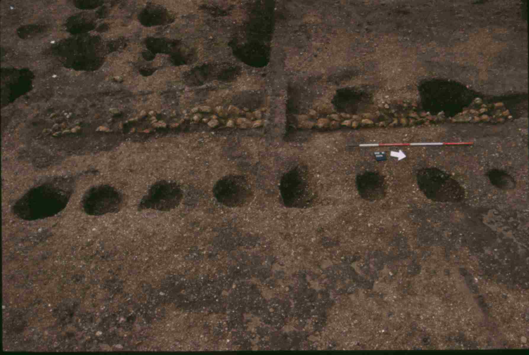
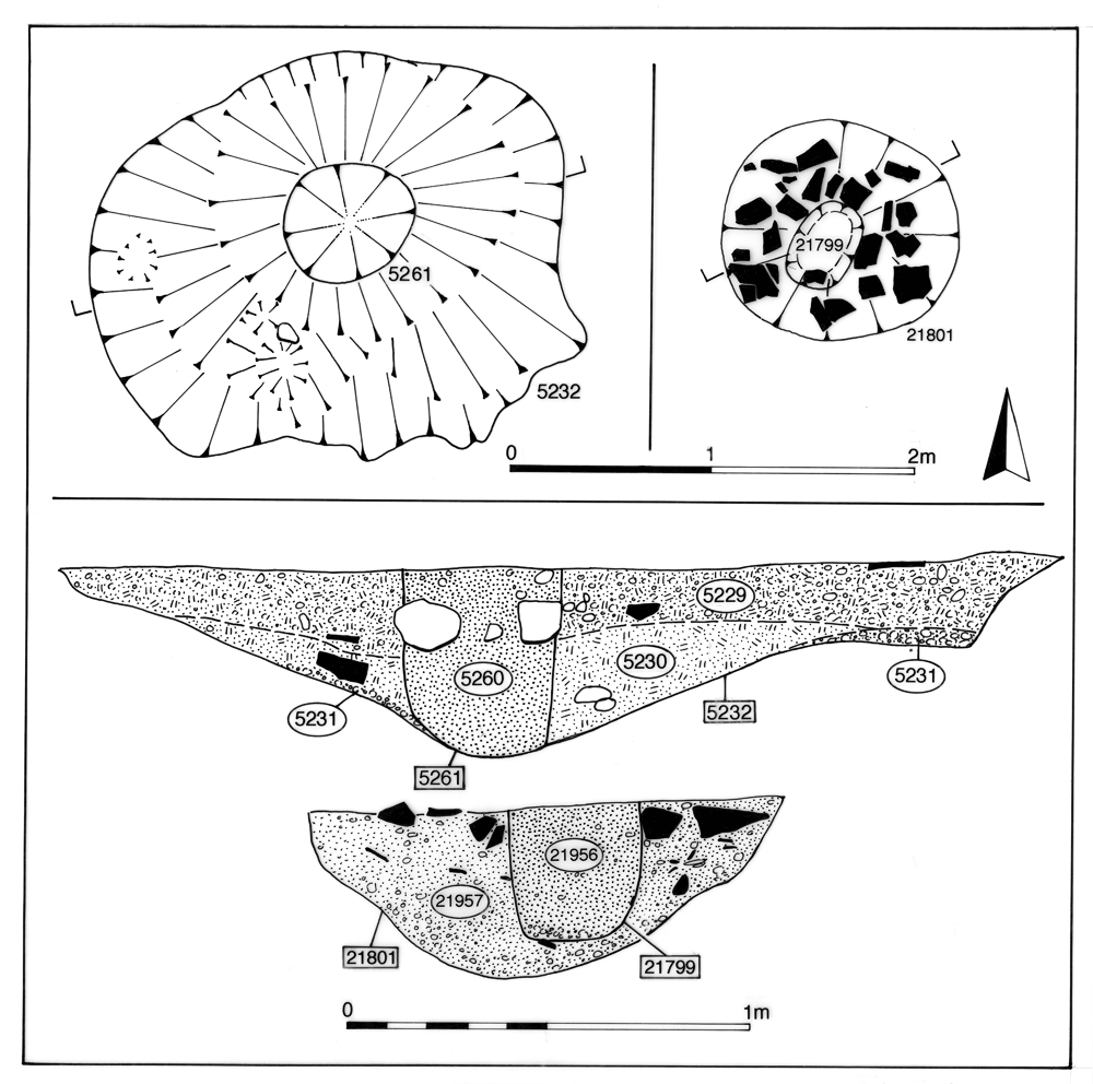
Other changes and enhancements are also undertaken during this period, perhaps at the same time as those to the temple cella interior. In overview, they amount to an expansion and maintenance of open space within the precinct. A monumental post (pit 5232, Group 427), c. 0.4m in diameter, is erected in the north-eastern corner of the precinct in the 3rd century and perhaps survives until the late 4th century (Figure 149). This is likely to function as a highly visible marker, perhaps something like a 'Jupiter-column', while its relatively peripheral position may suggest that the maintenance of open space within the precinct is important. A local parallel for such a marker may be found with monumental post-hole F1977 at Witham Ivy Chimneys (Turner 1999, 40) which similarly does not occupy a prominent or central place within its religious complex.
At the southern precinct boundary, alongside Road 3, the continuing shift of temple-related deposition to the peripheries is reflected in the positioning of pits 5394 and 13084 (Group 432) and roadside hollow/pit 5093 (Group 433 - see Road 3, above). These contain significant quantities of oyster shell and chicken bones (Figure 138), and in the case of 5394 a coin, hairpin and needle, which would seem to confirm structured deposition or disposal of devotional items along with food offerings/ritual consumption in selected liminal features. A single large pit (22114, Group 431) is dug on the eastern periphery. Located in the north-eastern corner of the precinct, and mostly containing tile and animal bone, this pit does not appear to have attracted the type of votive deposition seen elsewhere in the precinct during Period 4.
Also on the eastern side of the temple precinct, and in the area around the entrance through the eastern precinct screen wall, an accumulation of silts (Groups 423, 424 not illustrated) on the earlier Period 3 metalled surface reflect the use of this access and the space in front of the temple. This area is resurfaced (Group 425) in the later 2nd or early 3rd century AD, the latest to survive in OA23, and is subsequently cut by the major reconstruction of the eastern temple precinct wall (Structure 46 Group 426), though it is presumed that the use of the surface persists.
Other than resurfacing of the area in the immediate vicinity of the entrance through the eastern temple precinct boundary wall (see Group 425, above), no activity can be defined across OA45 within this period (Figure 134). However, it is possible that likely well 22210, just outside the entrance and later reused as a votive pool (Group 448 Period 5), has its origins in this period - perhaps being used as a water source at which to ritually cleanse or, more practically, quench the thirst of approaching temple visitors. During Period 4, therefore, the area to the east of the temple precinct between Road/tracks 3 and 4 is concluded to remain a clear, open, at least partially gravel-surfaced space, the maintenance and use of which is presumably closely associated with the activities of the temple complex.
The interior of OA18 is reorganised in the early 2nd century (Period 3B), when it becomes an essentially open space, albeit subdivided by fences and covered by dumps of midden-type material that is almost certainly derived from the settlement focus further west. The markedly low occurrence of Period 4 features within Open Area 18 suggests that this use continues. While its boundaries remain constant, some of the markers or barriers along them are modified and/or replaced (Figure 150).
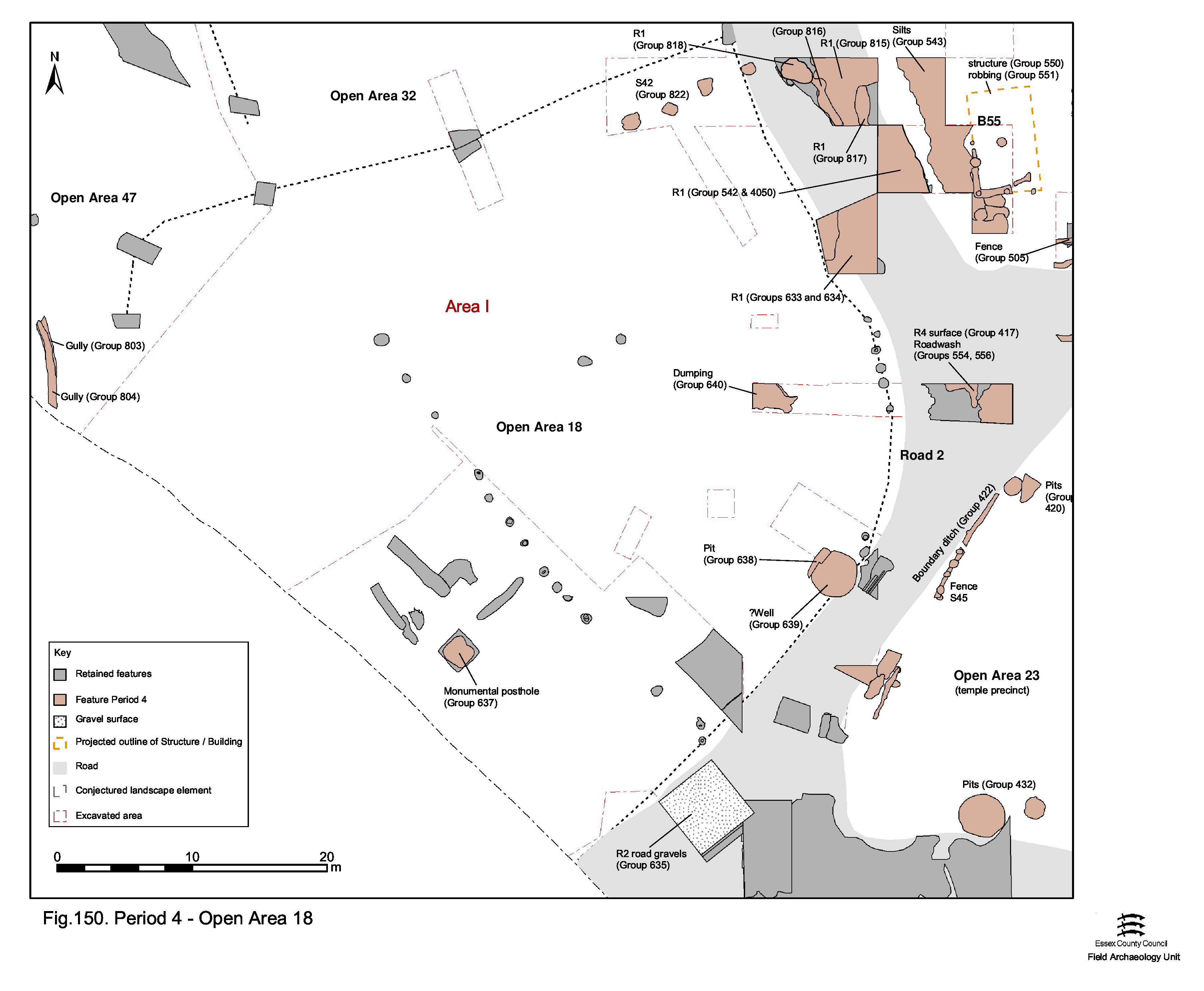
A new and substantial fenceline is inserted along the boundary between OA18 and OA32, as represented by a line of similarly sized and spaced clay-lined post-holes (Structure 42 Group 822), replacing or supplementing boundary ditch 25015 (Group 777 Period 3C). The ditch seems to become infilled as a result, though its eastern part is later re-established in Period 5. Although not traced along the full length of the ditch, it is presumed that the fence runs west along much of the boundary, perhaps stopping short of its southward return.
It is unclear whether or not the interior of OA18 is subdivided in the mid-Roman period, as it has been previously. Given the disappearance of Buildings 49, 50 and 51 from the road frontage, the abandonment of latrine trench 25049, the non-replacement of the early Roman hearths, clearance of features around the monumental post, and the generally low incidence of pits, it would seem that this plot may well become a single, undivided and largely unoccupied entity. Indeed, its most conspicuous surviving feature, the monumental post (Group 617) erected in the western part of the open area in Period 3B, seems to stand in splendid isolation in what could perhaps be a fairly central position (if the western end of the curving northern boundary ditch can be construed to extend in a straight line to meet the continuation of Road 2). It stands until toward the end of Period 4 (early/mid-3rd century) when it is removed by digging a 0.5m-deep cut (13433 Group 637) into the clay packing deposit around the foot of the post, thus working it free - as indicated by the splayed post-clast. The space around this post, and perhaps more-or-less all of this near empty land unit, is presumably a focus of some importance and may well have been a 'public' area associated with the temple complex on the opposite side of the road.
Admittedly, a significant proportion of the OA18 interior was not investigated, but it can reasonably be assumed that, if present, most middle and Late Roman remains should have been apparent in plan. The low and largely peripheral incidence of such surface remains on the pre-excavation plan is therefore tentatively interpreted as indicating a tendency for occupying remains to be positioned along the boundaries. These include a possible well (5806 Group 639) and earlier 3rd century pit (5829 Group 638) at the edge of Road 2. Other pits of mid-3rd century AD date (Group 641) are sparsely scattered across the open area. All are located towards the peripheries of the plot, in contrast to earlier pits, and all appear to have been filled principally with domestic rubbish, although pit 13158, close to the likely well, is notable for its inclusion of both slag and lead cast waste (SF3522, SF8392). The pits cut an episode of dumping (Group 640). Midden-type deposits 13146 and 13211 are composed almost entirely of oyster shell, over 100kg of which was collected, but may originally have included other organic rubbish. Although the full extent of this midden was not determined, it is clearly in excess of 3m diameter. It would appear that the discard of oyster shell is its primary use. The increased occurrence of large quantities of oyster shell is also noted in the temple precinct during this period.
Mid-Roman use of OA19 is essentially marked by continuity from that in Period 3 (Figure 151). The predominant character of this plot remains one of open gravelled surfaces. As a result, it is not always possible to define clear period boundaries within this excavated sequence and there is almost certainly some chronological overlap between the end of Period 3 and the start of Period 4 and similarly between the end of Period 4 and the start of Period 5. As is the case in Period 3, an east-west split in the character and perhaps function of OA19 is evident, though the precise point of the division is unclear. Consequently, there is a need to distinguish between the western end of OA19 (Excavation Area H) with the remainder to the east (within Excavation Areas L and M).

Along the southern side of OA19, flanking Road 4, poorly dated Roman pit 6141 (Group 544) is post-dated by a fenceline (Groups 545, 549). Some parts of this structure (Group 545) pre-dates and some (Group 549) post-dates the second episode of Period 4 road resurfacing (Group 417). Further elements (Group 557) occur yet further up the stratigraphic sequence (post-dating road-wash Group 556). This evidence is taken as representing the survival of the fence, with repair and/or modification, throughout Period 4.
The various localised gravel resurfacings and repairs of the plot interior are broadly dated to the mid-2nd to mid-3rd centuries; in effect they demonstrate the major continuity of use throughout Period 4. An initial resurfacing comprises gravels (Group 537) laid down on make-ups (Group 515). On the north side of OA19, this resurfacing is cut by ditch 25259 flanking Road 5 (Group 539, as noted earlier). On the southern side of OA19, this same surface is probably sealed by further gravels lying along the side of Road 4 (Group 517), which probably date to the mid-2nd to mid-3rd centuries AD; a complex sequence of gravel surfaces interleaving with road-wash seems to be present. Road-wash silts also accumulate alongside the Road 1/4 junction (Group 543). These encroach upon the edge of Road 1 (Group 542, see above) and some underlie Building 55. Their dating is predominantly later 2nd to early 3rd century AD, but deposition probably continues up to the late 4th century AD.
Make-ups and gravel surfaces (Group 547), continue to be laid down in the interior of OA19 during the late 2nd to early 3rd centuries AD. Some surfaces show evidence of repair and others are overlain by silty accumulations that may relate to the use of the surface. Most appear to be degraded but some are notable for the incorporation of animal bone (chiefly cattle scapula and mandible) in their construction; wear hollows 16204 and 16342 are filled with selected bone packed in gravel but little else. On the whole, these gravel surfaces contain significantly more finds than earlier surfacing deposits; the incidence of coins is particularly noted. However, this may merely be a product of increased material culture and surface rubbish, resulting in increased incorporation of such material at the time of construction.
Building 55 (Figure 152), probably erected in the late 2nd or early 3rd century, is inserted into the south-west corner of OA19, close to the Road 1/4 junction. Shallow foundation slots (6288/6291 Group 550), packed with fragments of tile, burnt clay and flint cobbles, and containing post-settings (Group 551), define the south-western part of this rectilinear building. This foundation packing is similar to that found in broadly contemporary Building 54, which occupies a similar position in adjacent OA33. The proliferation of rubbish within the building, sealed by its destruction debris (Groups 574, 576 Period 5), hints that it may be abandoned prior to apparently being destroyed by fire in the late 3rd century.

Rectilinear post-and-slot Building 56 (Groups 548, 565) is sited along the north side of Road 4, to the east of Building 55 (Figure 153). The south wall of this c.10 x 6m building runs more-or-less on the same alignment as the roadside fenceline. The structure overlies gravel surfacing and a pit (Group 558) of late 2nd century AD date.

To the south of Building 56, silts wash off the road surface and accumulate along the edges of Road 4 during the late 2nd and early 3rd centuries AD (Groups 554, 555, 556). These layers gradually build up and encroach upon the road surfaces and suggest that Road 4 is no longer actively maintained beyond the early 3rd century AD, although its continued use is likely until as late as the 4th century AD.
Centrally positioned well 6280 (Group 531 Period 3), possibly remains in use into the earlier part of this mid-Roman period, after which infilling starts at the end of the 2nd or beginning of the 3rd century. The first infill indicative of the well's disuse as a water source (fill 16083) contains a number of near-complete ceramic vessels (KPG26), butchered animal bone, wooden objects (SF5667, SF7185), shoe leather and rope (SF5484). While this could simply constitute a well-preserved assemblage of general rubbish in a redundant feature, its potential significance as a structured closure deposit is a real possibility, and is explored elsewhere (Vol. 1, Chapter 6). Succeeding fills denote seemingly rapid and probably deliberate collapse, backfilling and levelling of the disused well shaft. Notably, uppermost fill 6281 contains a fragment of a copper-alloy letter (SF2347) that is almost certainly derived from votive activities of the adjacent temple precinct.
The demise of the well may signal something of a change of use of this open area. Although the mid-Roman pits do not stand out from those of earlier phases in terms of still having relatively little material culture disposed in them, there appears to be a tendency toward square plans and an increase in quantity. As excavated, the majority of the pits define two clusters at the centre and south side of Excavation Area H/OA19. The first, central, cluster lies to the north (Group 559) and north-east (Group 546, 561) of Building 55, broadly located over and around the disused and backfilled well 6280. All are of square shape and uniform proportion. The second, southern cluster (Group 553), close to Road 4, coincides with the location of the former storage jar oven cluster of Period 3. Generally larger, the majority of these are also roughly square. Even outlying pit 16315 (Group 560) alongside Building 56, close to Road 4, could perhaps be construed to be sub-square. A circular pit 6151 (Group 552) lies between these perceived clusters of square pits. The finds assemblages from both clusters are characterised by large quantities of tile, pottery and bone, along with a significant metalwork component. Notably, circular pit 16149 (Group 559) is cut by a smaller feature, 16108, which contains the lower half of a ceramic vessel probably inserted whole and upright into 16149. While a practical use is probable, 'ritual' deposition is not discounted.
The nature and use of the eastern part of OA19 (Figure 151) is unclear during the mid-Roman period. Although there is no indication that the interior surface is maintained or renewed, it is possible that use of the surviving Period 3 surface persists. While much of the enclosure is probably still largely open, it is now encroached upon by at least one building and perhaps associated sub-enclosures or pens.
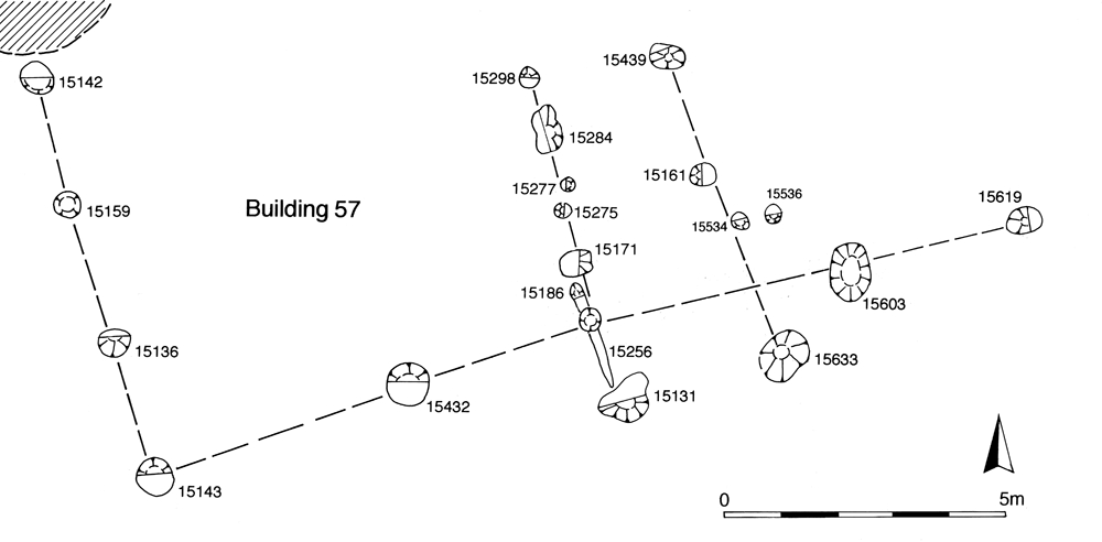
Post-built Building 57 (Figure 170), at the far eastern end of OA19, is a highly conjectural post-built structure (Group 467). The proposed building layout is rectilinear and may comprise a central corridor leading from a south-facing porch flanked by a room on either side, c. 18m x 9m in extent. It is probably constructed in the early to mid-3rd century and demolished by the 4th century. Single pit 15227/15271 (Group 468) lies to the north of Building 57. The general paucity of pits and other remains across the eastern interior of OA19 is notable. However, other occupying remains may simply be relatively short-lived structures. Potentially parallel lines of posts may denote the presence of sub-enclosures to the south of Building 57.
There is a clear distinction to be made between the western and eastern parts of the Southern Zone in Period 4 (Figure 135). In the west, Open Area 28 remained a discrete enclosure throughout the mid-Roman period, and the activity within it displayed continuities with that of the preceding period. Further east, however, most of the long-standing enclosure boundaries appear to have been abandoned, inferring that OAs 24-27 also ceased to exist as distinct entities. Land-use beyond their demise is considered as a single block between Road 3 and the lower terrace edge, hereafter referred to as Open Area 50.
Located at the western end of the Southern Zone, OA28 may be perceived to constitute more of a Central Zone entity than a Southern Zone one. Its eastern boundary, perhaps very pertinently more-or-less lying on the same line as the temple precinct wall, could always have been a significant settlement watershed. It is also worth remembering that OA28 is a Road 2, as well as Road 3, frontage plot - important if Roads 1 and 2 are accepted as the route between Chelmsford and Colchester. It is likely, therefore, that this plot is regarded at the time as part of the core settlement of properties lining the principal thoroughfare and is retained as a distinct entity through Period 4 - despite fundamental change across the remainder of the Southern Zone.
The majority of the Southern Zone might become more like the Northern Hinterland in this mid-Roman period. The simplification of its division and siting of dirty manufacturing and processing activities - represented by pottery kilns and crop-drying floors - suggests that this part of the settlement becomes increasingly peripheral.
Within OA28 (Figure 154), roadside Building 39 probably remains in use into the early 3rd century. There is no encroachment upon its footprint by pits or other features during Period 4, though an accumulation (4706 Group 905) over the remains of the building contains pottery that may indicate an earlier 3rd century AD date for its abandonment; the presence of a Severan denarius in the (possibly disturbed) floor of the building has already been noted.

Open Area 28 continues to show a distinction between the west, where the building stands, and the east, where industrial or agricultural processes and waste disposal in pits takes place. Manufacturing or processing activity is represented by small tile-built oven/drying floor 4284 (Groups 733, 734, 735) (Figure 139) and the more fragmentary remains of a second drying floor 4003 and parts of its superstructure (Group 736, 737). A curving gully and related post-holes (Group 738) on the western side of the latter structure presumably constitute an associated windbreak. The occurrence of small amounts of slag and mould fragments (SF8517) in burnt layer 4909 (Group 736), and the frequent finds of slags and copper-alloy fragments/waste from many deposits in the vicinity, could suggest a metalworking function but the form of the extant remains suggest a drying floor rather than a high-temperature oven or kiln. Oven/drying floor 4284 is in use in the mid-to-late-2nd century AD and falls out of use in the early 3rd century, and so is almost certainly in use at the same time as Building 39.

The remainder of the eastern part of OA28 is occupied by pitting (Group 739), as is previously the case in Period 3. However, their frequency is reduced, with some appearing to be a direct reuse of earlier features (e.g. pit 4083 over Period 3 pit 4010). The occurrence of paired pits (e.g. 4426 and 4487, 4016 and 4102) represents another strand of continuity of pit-digging/disposal activity from Period 3. Despite these elements of continuity, the composition of artefactual assemblages from pit fills demonstrates a change from Period 3; while briquetage remains common, metalworking debris is absent and metal objects are now more likely to be iron than copper alloy. Of particular note is pit 4943, with its relatively high finds density that included animal bone waste (and a single human baby bone), iron tools and a bone weaving tool (SF5702). Further bone objects - needle (SF6836) and cut horn (SF7396) in pit 4083 and hairpin (SF385) in 4016 - may suggest bone-working activity within OA28 during Period 4.
Additionally, a series of dump layers (Group 740) overlie some of the mid-Roman pits and may indicate the presence of middens in this vicinity of the settlement.
To the east of OA28 - in essence beyond the settlement core - a reorganisation of the Southern Zone occurred sometime during Period 4. Ditch 25178 (Group 144 Period 2B) and subsidiary boundary fence/hedge alongside (25093 Group 208 Period 2B) previously divide OA24 and OA25. In Period 4, relatively substantial ditch 25177 (Group 668) is cut straight across this boundary line, extending roughly eastwards from a presumed terminal within OA25 to the limit of Excavation Area A2; a distance of some c. 50m. Pottery from its fills places its infilling in the late 2nd to early 3rd centuries AD. One, or possibly two, minor linear features on a similar alignment are recorded in plan immediately to the north. Unfortunately these are not excavated and remain undated, but it is possible that ditch 25177 forms only one, albeit major, element of a more complex reorganisation of the enclosures.
Further west an analogous process seems to be represented by gully or slot Structure 48 (25087 Group 697). This feature, although insubstantial, discontinuous and only partially excavated, clearly cuts the ditch (25081 Group 146) which until now forms the boundary between OAs 26 and 27. Pre-excavation plans show it quite clearly for at least 21m, and suggest a right-angled turn to the north at its western end, but this was not explored. Although almost certainly structural, Structure 48 is unlikely to form part of a building as it is too extensive, and it is more probably a fenceline or similar defining the corner of a pen or small enclosure. The sparse dating evidence suggests its fills date to the 3rd century AD or slightly later.
The fate of the double boundary ditch between Open Areas 26 and 25 is less clear, particularly as the ditched boundary itself is probably already replaced/perpetuated by a hedge prior to this. However, the construction of a kiln on top of the ditch fills may imply that this boundary is also redundant.
During Period 4, therefore, it seems that the regular rectilinear enclosure system that previously defines Open Areas 24, 25, 26 and 27 is swept away and replaced by a new large land unit - Open Area 50 (Figure 155). The limited scope of excavation makes it impossible to determine whether Open Area 50 is one single enclosure or subdivided by structures such as Structure 48 into smaller blocks. It is also unclear whether it extends north over the line of Road/track 3 to merge with OA45, though it is perhaps noteworthy that ditch 25177 disregards the alignment of Road 3 to its north, instead being influenced by Roads 4 and 5, suggesting that the route of Road 3 to the east of the temple precinct and Open Area 28 is no longer a significant influence on the landscape. The continuing decline, perhaps even disuse, of the eastern part of Road/track 3 is indicated by the encroachment of a Period 4 pit cluster (20185, 20225, 20308, 20318 Group 711). For the purposes of this report, and in the absence of a more tangible subdivision of the Southern Zone in Period 4, Open Area 50 is held to represent the amalgamated area of the Southern Zone to the east of Open Area 28 and south of Road 3.
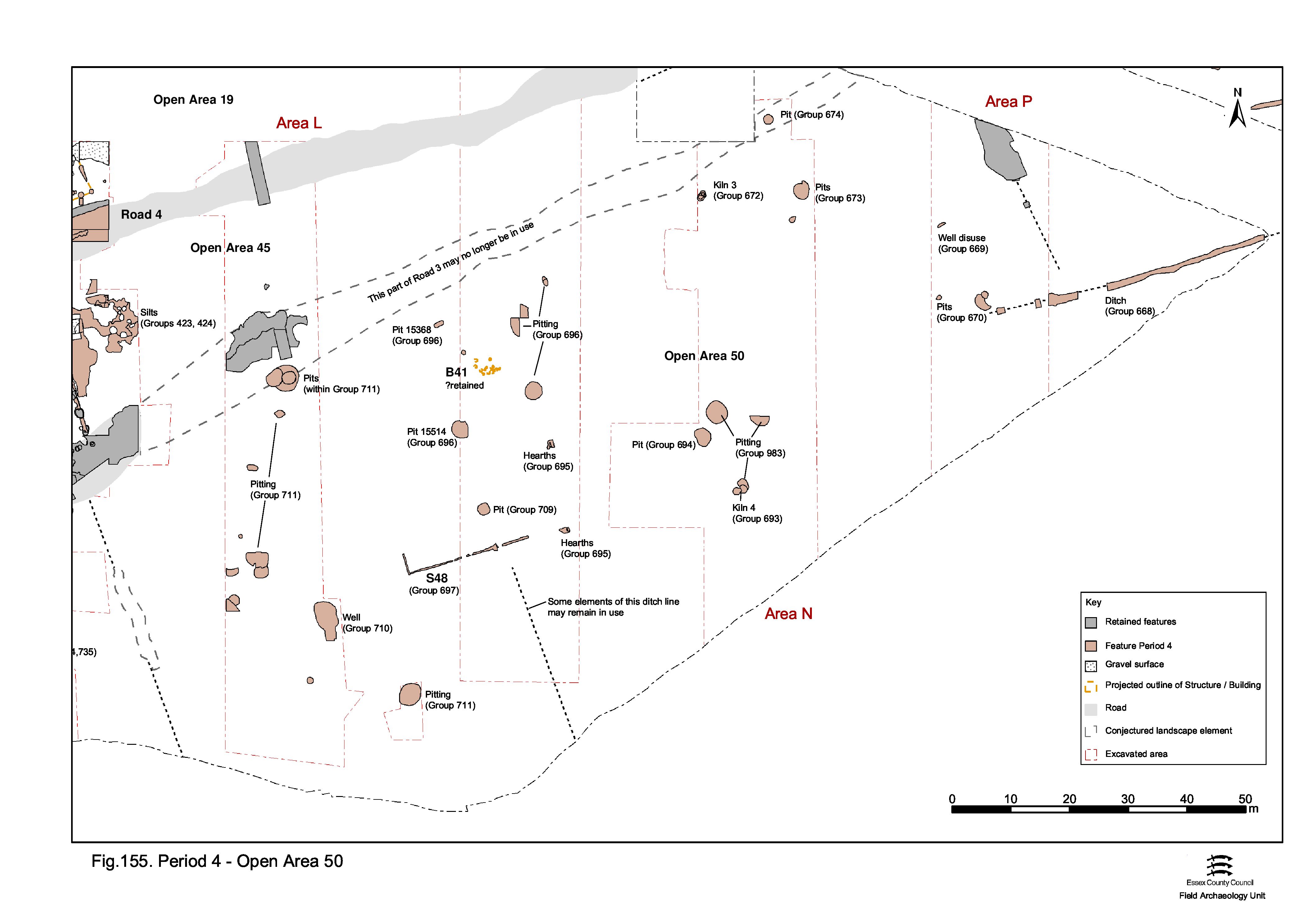
It is possible that Building 41 continues in use into Period 4 (Figure 155). It is noticeable that pit 15514 (Group 696), with a fill of domestic food waste, is situated just south of it. However, it is not possible to determine whether the building survives the creation of OA50 - it is perhaps safest to tentatively presume not. There are no other buildings recognised to be present within OA50, either surviving from Period 3 or new - Structure 48 having been discounted as one. While the limited extent of investigation carried out across the Southern Zone means that the absence of further buildings is not certain, it seems that there is a very low level of occupation within the newly created Open Area 50. Indeed, Period 4 features of all types are infrequent and those that do occur tend to be concentrated in the west of the open area, toward the settlement core. Here, one of the more significant mid-Roman developments is the construction of well 14984, the timbers of which are dated by dendrochronology to April/May AD 151, a little to the west of Structure 48. The only other activity around the well and Structure 48 is pitting.
Past of Structure 48, pits become extremely sparse and widely scattered. Their dating perhaps hints that they may be dug slightly later in Period 4 than the more western pits. Mid-Roman pits are rare in the eastern part of Open Area 50 and the presence of such features as drying floors and kilns could indicate that this vicinity has become depopulated and peripheral to the settlement, with processing and manufacturing activity replacing occupation (though land-use may well have continued to be predominantly pastoral). Furthermore, it may be reasonably postulated that the more dirty and industrial the activity, the further east it is located.
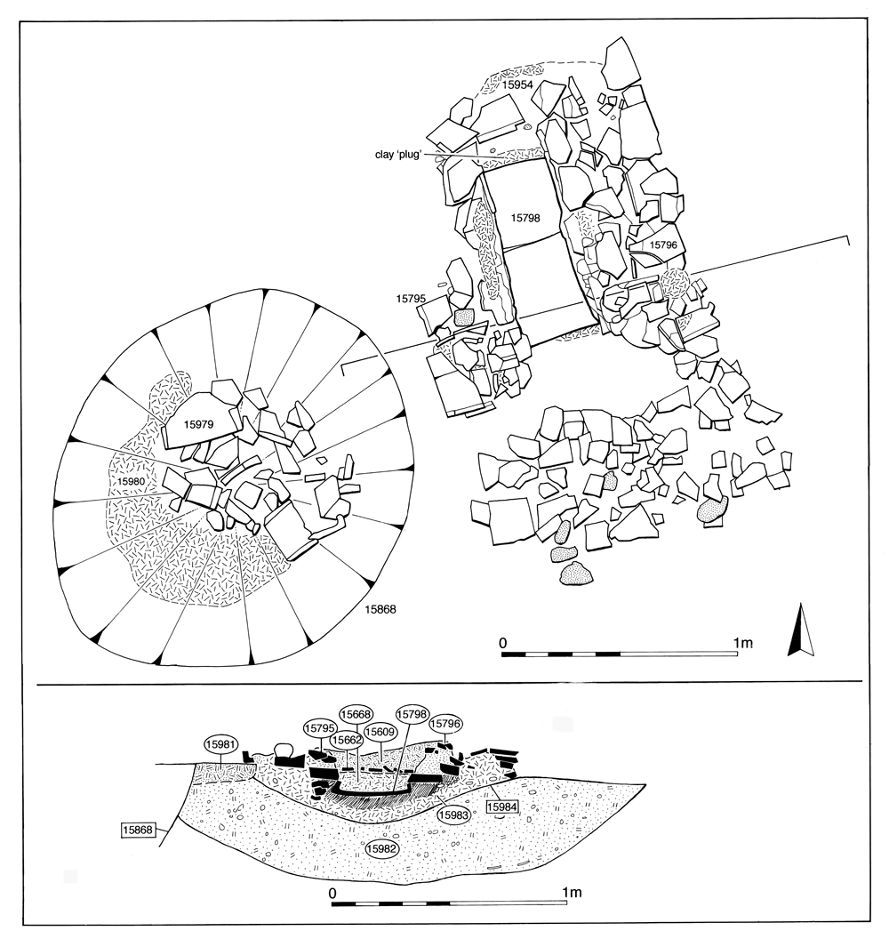
Two drying floors (Group 695) lie a little to the east of Structure 48. 15638 is severely truncated, but 15984 comprises the lower parts of a tile-built structure that may originally be L- or T-shaped, and constitute the flue for a (lost) main chamber (Figure 156). An area of scorched clay (15893) at the southern end may indicate the position of the stoke-hole. Its construction is dated to the late 2nd to early 3rd centuries AD. As the demolition debris (Group 751 Period 4) over 15984 also seals an adjacent Late Roman pit (15868 Group 898 Period 5), it is possible that this drying structure remains in use for some time.

Well 14984 (Group 710) lies to the west of Structure 48. The remains of a square, plank-built shaft, surrounded by a number of vertical supporting stakes, occupies an irregularly oval, near-vertical sided construction cut packed with orange clay (Figure 157). The well is originally c. 2m deep. Integral to the construction cut is a 2m-wide ramp sloping down into the south side of the well. The ramp is lined with the same orange clay but it is unclear whether it remains in use as a means of access to the water source beyond the construction phase. A felling date of April/May AD151 has been obtained for the well-shaft timbers and construction cut backfills contain a small amount of 2nd century AD material. The fills within the well, however, appear to relate to its disuse only, but suggest that it remains in use as late as the end of the 3rd century AD.

Two kilns, both of East Anglian Wattisfield-type (Swan 1984, 115), are sited further east within Open Area 50. Although not directly contemporary with one another, their periods of use may overlap. The earlier Kiln 11423 (Group 693) is probably built in the later 2nd century AD and contains remnants of a charcoal-rich primary use deposit, overlain by silts containing kiln wall fabric (Figure 158). Repair to the flue entrance is apparent, perhaps suggesting relatively prolonged use. Archaeomagnetic dating has provided a date range of c. AD 225-250 for its last firing. Although the morphology of this structure would indicate that it is a pottery kiln, there is no evidence for any possible product other than a clay phallus (SF7625) from a stoke-hole fill (Figure 140).
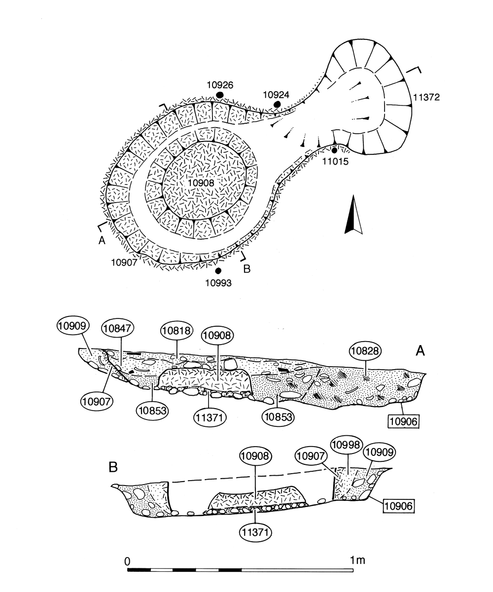
The second mid-Roman kiln 10906 (Group 672) is constructed at a slightly later date (early 3rd century AD) further north in OA50, alongside Road/track 3 (Figure 159). Although less well preserved than its southern counterpart, and lacking in situ use deposits, its morphology is also that of a Wattisfield-type kiln and features stake-holes interpreted as indicating the presence of a framework supporting the kiln superstructure. At only 1.2m maximum width, and lacking distinct evidence of intense burning, this kiln is perhaps more likely used in the firing of small items before falling out of use by the mid-3rd century.
Other than this processing and manufacturing activity, the intensity of use of OA50 appears to be low. Pits are noticeably scarcer than in previous periods; excavated examples being limited to a small quantity lying to the north (Group 696) and west (Group 711) of Structure 48. The northern pits fall into two types: the majority are large, circular cuts, some 2.0m to 5.0m in diameter, and the remainder are smaller and oval in shape. As noted previously, it is possible that pit 15514 is deliberately located close to the northern terminal of a boundary represented by 25081. There certainly seems to be a tendency for the pits to favour peripheral locations within Open Area 50 and to avoid the central part occupied by Structure 48, 25081, the hearths of Group 695 and well 14984. Small pit 15368, for example, conforms to this pattern and may be the most significant of them - it occupies a near-roadside position and contains only a bronze flagon (SF2996), the deposition of which almost certainly has ritual significance (see Atkinson and Preston 2015, Chapter 6). The other small pits contain few finds. Of the larger pits, only 15514 was excavated to any great extent. It contains a larger and more varied finds assemblage than earlier pits, including quantities of ironwork and characteristically large amounts of pottery, tile (including voussoirs), animal bone and oyster shell.
The pits of Group 711 tend to occur in tight, inter-cutting clusters, generally rounded in plan and 2-5m in diameter. One of these clusters, which encroaches on the line of Road 3, has been mentioned above. Widely dispersed and isolated small pits such as 14442, 14994 and 20138 also occur, however. Apart from quantities of pottery and tile, finds assemblages within these pits are both less numerous and less varied than in the preceding period. Animal bone is present in reasonable quantity, but metalwork is very scarce. There are no copper-alloy artefacts and the only iron objects present are nails. A solitary possible litharge fragment (SF6277) in small pit 14994 is considered as residual and not indicative of metalworking in this period.
Later Period 4 pitting, that is those discernibly dating to the first half of the 3rd century AD, is represented by Groups 670, 673, 674, 680, 694. The pits of Group 670 cluster at the western terminal of major boundary ditch 25177. The tendency for pits to be in peripheral locations close to boundary features and to avoid the centre of Open Area 50 is noted. Pits 10953, 10995 (Group 673), 11304 (Group 674) and 11361 (Group 680) vary in size but all contain significantly larger artefact assemblages than pits of the preceding periods. Animal bone and ceramic building materials account for most of this increase, though smaller artefacts, particularly ironwork, are also more prolific. Pit 10995 (Group 673) may be filled by the mid-3rd century AD but 10953, and 10304 (Group 674), which lie on Road 3 and provide further confirmation of the road's decline, may continue to receive material until the mid-4th century AD. Pit 23012 (Group 694) contains a relatively complex sequence of fills: lower fill 23020 dates to the late 2nd/mid-3rd century AD, middle fills 23019, 23087 to the mid-3rd century AD (23087 includes two complete ceramic vessels -and top fill 23010 to the later 3rd century AD. Separate episodes of filling appear to be demonstrated.
The deposition of material in the hollows over defunct, earlier features is also evident. Some larger Period 3 features, such as well 8989 and boundary 25221, remain open long enough to continue to accumulate material during Period 4; both contain 3rd century AD artefacts in their upper fills. In the former case this later accumulation is defined by Group 669. In the latter case this secondary deposition material is not grouped separately (see Group 663).
The pre-existing boundaries subdividing that part of the Northern Zone to the west of Road 1 seem to remain in use during Period 4, though this is far from certain (Figure 135). The major ditch (25021 Group 776), separating Open Areas 47/48 from the enclosures further east, continues to receive infill containing artefacts of mid-Roman date, particularly at its southern end, closest to the perceived settlement core. Whether these fills are accumulating within a ditch that still forms an active boundary or rather represents deposits accumulating at the foot of a hedge or similar, perpetuating the boundary line, is unknown. It may, however, be significant that most vestiges of Period 4 activity lie to the east of this feature - i.e. toward Road 1.
It is possible that other Northern Zone boundaries could be modified or perpetuated by non-archaeologically-defined means (e.g. hedges). Consequently, the status of other parts of its subdivision remains ambivalent. For example, there is no direct evidence to indicate that the boundaries of Open Area 32 are still in use, but the burial (Group 809), in the mid-3rd century or later, of an adult woman in a shallow grave that is both next to, and orthogonal with, the delineating ditch between OAs 32 and 49 makes it likely that this boundary is at least visible in some way.
All the same uncertainties over boundaries apply equally to that part of the Northern Zone to the east of Road 1. No new boundaries or subdivisions are established during Period 4, and the Period 3 gravel surfaces within some of its constituent open areas are not renewed and become buried. Here, the landscape may continue to be subdivided into four enclosures by a broadly cruciform arrangement of boundaries, though the status of the east-west aligned boundary is particularly uncertain as some Period 3 pits appear to encroach upon its line. The Period 3 subdivision of this part of the site into OAs 33-36 is, admittedly, maintained as much for convenience as any other reason and it remains possible that this part of the North Zone has differing or no tangible subdivisions at this time.
West of Road 1, there is no excavated evidence for any buildings occupying the Northern Zone, though there are traces of undefined and possibly short-lived structures in the north-west part of OA32 (Figure 160). Activity is otherwise almost entirely confined to scattered pitting, most of which lies east of ditch 25021. Within OA31 a slender thread of continuity may be represented by the close association between Period 4 pits 10012 and 10020 (Group 811) and Period 3 pits 10023 and 10044 (Group 789) respectively. Either re-cutting or continuing accumulation in developing slump hollows seems to be an aspect of many of these features in the 2nd and 3rd centuries and distinction or division between Periods 3 and 4 may not necessarily always be meaningful.
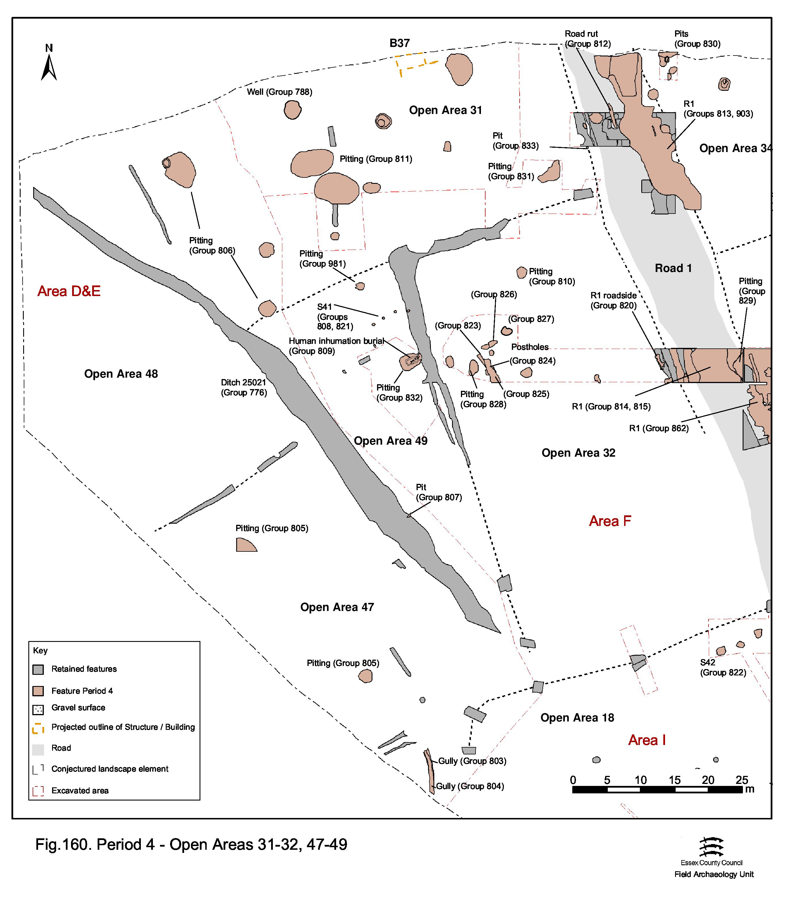
West of enduring boundary ditch 25021, Period 4 activity is limited to a low level of late 2nd to early 3rd century pitting within OA47 (Group 805); the interior of OA48 apparently being devoid of any remains of this date. It is noticeable that most Period 4 activity is manifest to the east of this boundary (Figure 160).
In OA49 (Figure 160), tentatively interpreted and dated circular post-built Structure 41 (Groups 808, 821) (Figure 168) lies close to the eastern boundary of the enclosure (if it is accepted that the boundary previously marked by 25039 endures this long). This structure is short lived, being encroached upon by late 2nd/early 3rd century pits. Most of the pits (Groups 832, 981 and 807) are seemingly placed in similarly peripheral locations toward the (presumed) boundaries of OA49. Northern pit 9243 (Group 981) could equally be viewed as part of the scatter of smaller pits in the south of OA31 (Group 806); which is quite possible as no formal boundary seems to exist between OAs 49 and 31 at this time.
Pit 8280 (Group 832) is placed in the approximate centre of OA40 and may be a later, mid-3rd century, addition. It is noticeably larger than the other pits of this period - which is seemingly a trend for late Period 4 pits elsewhere across the Northern Zone west of Road 1. Pit 8276 (Group 832) is another likely late Period 4 pit, being cut into the top of 8260. The infilling of Period 3 pit 8269 (Group 790) extends as late as the early/mid-3rd century.
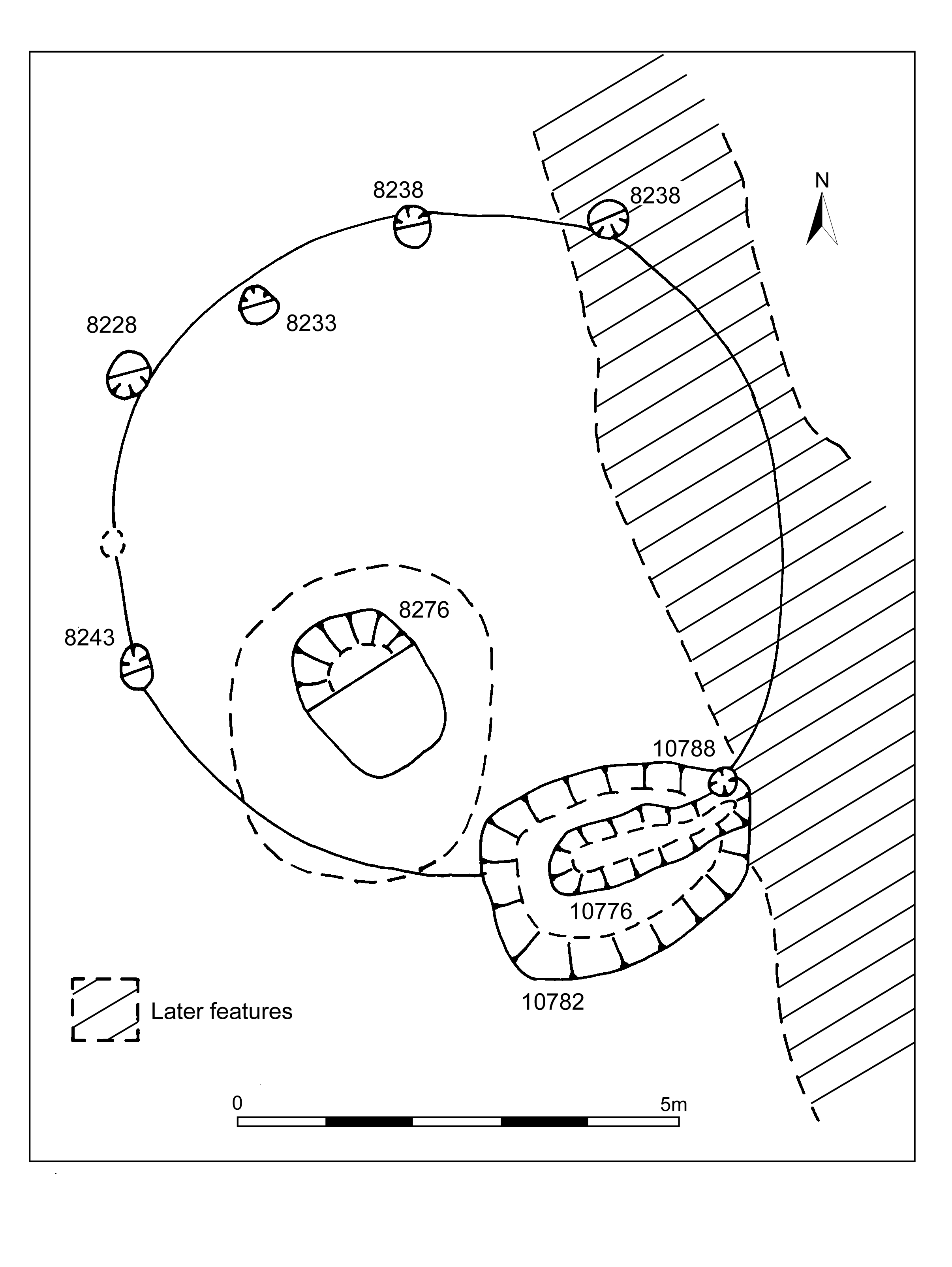
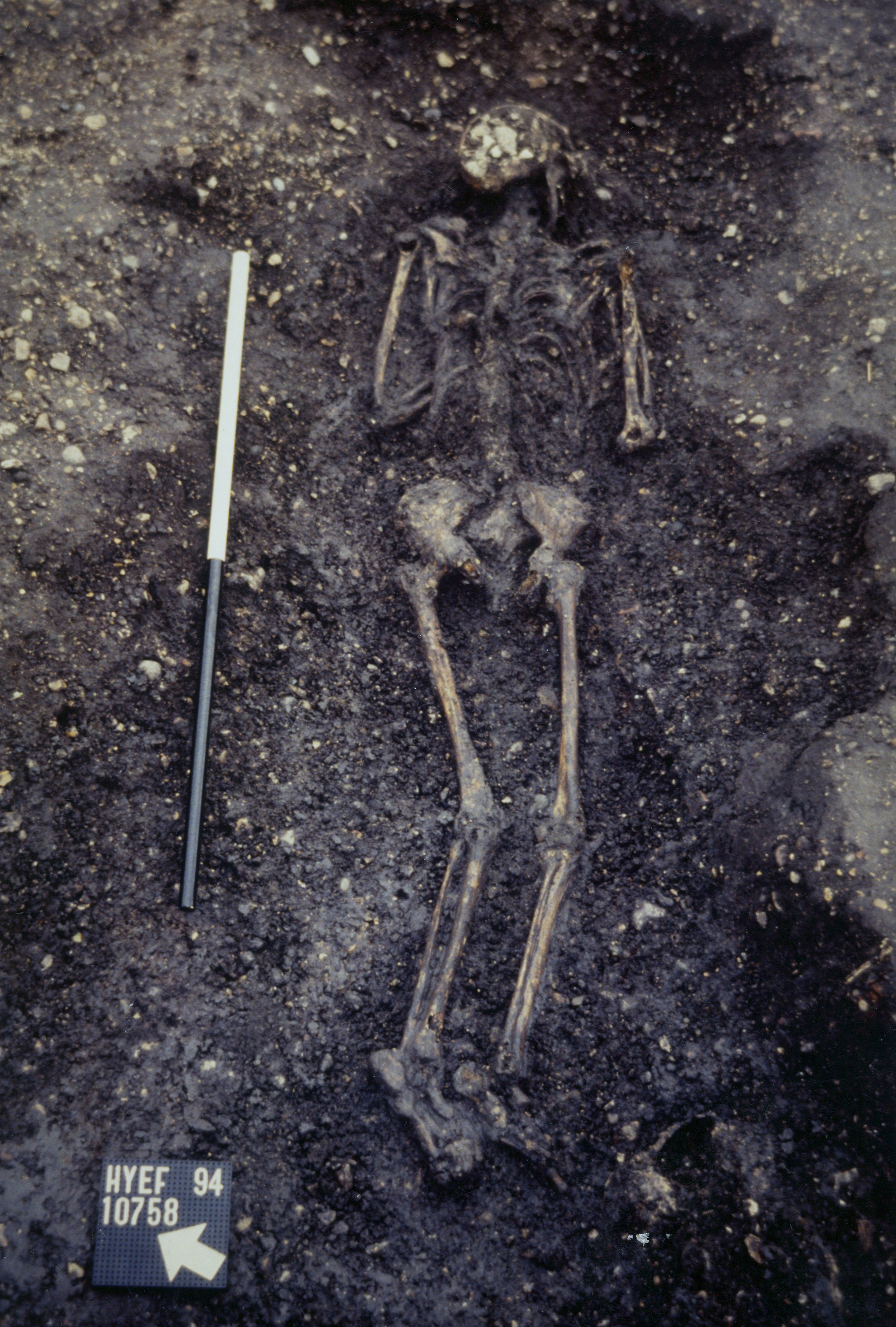
Inhumation grave 10776 (Group 809) is later cut into Group 832 pit 10782 (Figure 141). The grave cut is shallow and rather intangible and it remains possible that no real cut existed and that the burial is simply inserted into a convenient slump hollow in the top of the underlying pit. The adult female skeleton is laid extended prone, and unaccompanied by coffin or grave goods. This burial is both isolated and informal. A mid-3rd century date is indicated by the pottery present but this may be entirely derived from the underlying pit and it remains possible that the burial is rather later. Period 5 pits containing articulated human body parts are located to the north, in OA31, with which this burial could perhaps be alternatively associated.
Within OA31 ( Figure 160), pits (Groups 806, 811) of mid-2nd to early 3rd century AD date are scattered across much of its interior, with no apparent pattern to their distribution. There is, however, a clear size division between small (under c. 2m) and large (3.5-6.5m) examples. Solitary, and irregularly shaped, pit 10094 (Group 831) lies near Road 1, in the east of the enclosure. It contains a substantial amount of finds, including over 800 sherds of pottery dating to the later 2nd to early 3rd centuries.
All seem to be rubbish pits containing similar artefact assemblages, generally comprising large amounts of pottery and tile with a slightly higher incidence of metalwork (particularly iron objects, specifically nails) and animal bone than noted for earlier periods of pitting. The increased presence of nails may indicate a change in carpentry and building construction techniques (e.g. less reliance on jointing and pegging?) or else a change in disposal practice. For some of the pits, rubbish disposal may be a secondary function. 10055, a circular cut of 2.2m diameter, undergoes two episodes of clay-lining, the first being partially removed by cleaning or re-cutting and the latter truncated by a sequence of successive further re-cuts (10029 and 10006). This is analogous with earlier pit 10026 (Group 789 Period 3), which lay only 20m away to the south-east. There remains the possibility that these are incompletely excavated wells.
These Period 4 pits are not a distinct phenomenon, but represent a continuation of Period 3 practice; both 10012 and 10020 seem to be re-cuts of earlier pits (Group 789 Period 3) and some of the larger Period 3 pits may simply continue to accumulate material into the earlier part of Period 4. The use of some Period 4 pits may continue into Period 5; 10062 (Group 811) clearly begins filling in the mid-3rd century (KPG30, AD 250-260) but receives further material in the later 4th century.
An explanation of the apparent tendency towards fewer, larger pits containing fills with longer date ranges (also suggested in other areas of the site, though elsewhere it often seems to fall in Periods 5 and 6) may be a change in disposal practices. Waste material may now be accumulated in middens before its disposal in the larger pits.
The use of Period 3 well 8188 may persist into the early part of Period 4. Its shaft contains a sequence of fills indicating gradual organic-rich accumulation during use followed by disuse/collapse and infill deposits (Group 788). Use deposit 8196 is notable for the wooden objects it contains - a 'sword' and 'spatula blade' (SFs 2758 and 7603). The well appears to be backfilled by the late 2nd-early 3rd century.
Pits dated to the late 2nd to mid-3rd centuries AD are present in the northern part of Open Area 32 (Groups 810, 828) ( Figure 160). The finds from Group 828 are varied and relatively plentiful and include glass, iron and copper-alloy objects and cast waste, querns and other stone. Indeed, finds are more plentiful than from the contemporary pits to the east of Road 1.
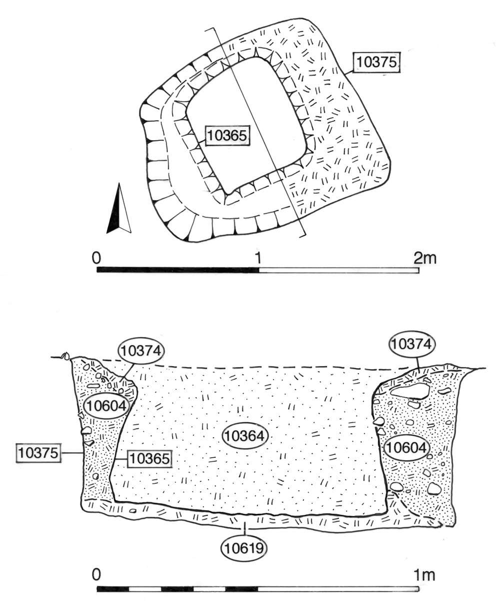
Miscellaneous structural activity in the centre of the enclosure is difficult to interpret, given their very restricted investigation within the Excavation Area F 'South Trench'. Located among the Group 828 pits, Groups 823 and 825 (Structure 43) comprise a series of narrow gullies, one of which (10537) is clay lined (Figure 169). Eight iron nails (SF5215) survived in situ within the clay, along with two stake-holes (Group 824). A square, clay-lined cut (10375) and pit 10648/post-pipe 10637 (Group 827) are located near the gully terminal and may be associated. It is apparent that the mid-Roman use of OA32 is more complex and widespread than is demonstrated by the limited investigation of its interior and the presence of mid-Roman buildings along its Road 1 frontage is suspected.
As noted above, it is assumed in the absence of contrary evidence that the enclosure system demarcating OAs 33-36 survived into Period 4 (Figure 161). However, it is equally possible that the whole of the east part of the Northern Zone, as bounded by Roads 1 and 5, and the watercourse, is part of a single property belonging to newly imposed Building 54, though the detail of its use during this period, as in those preceding, is unclear.
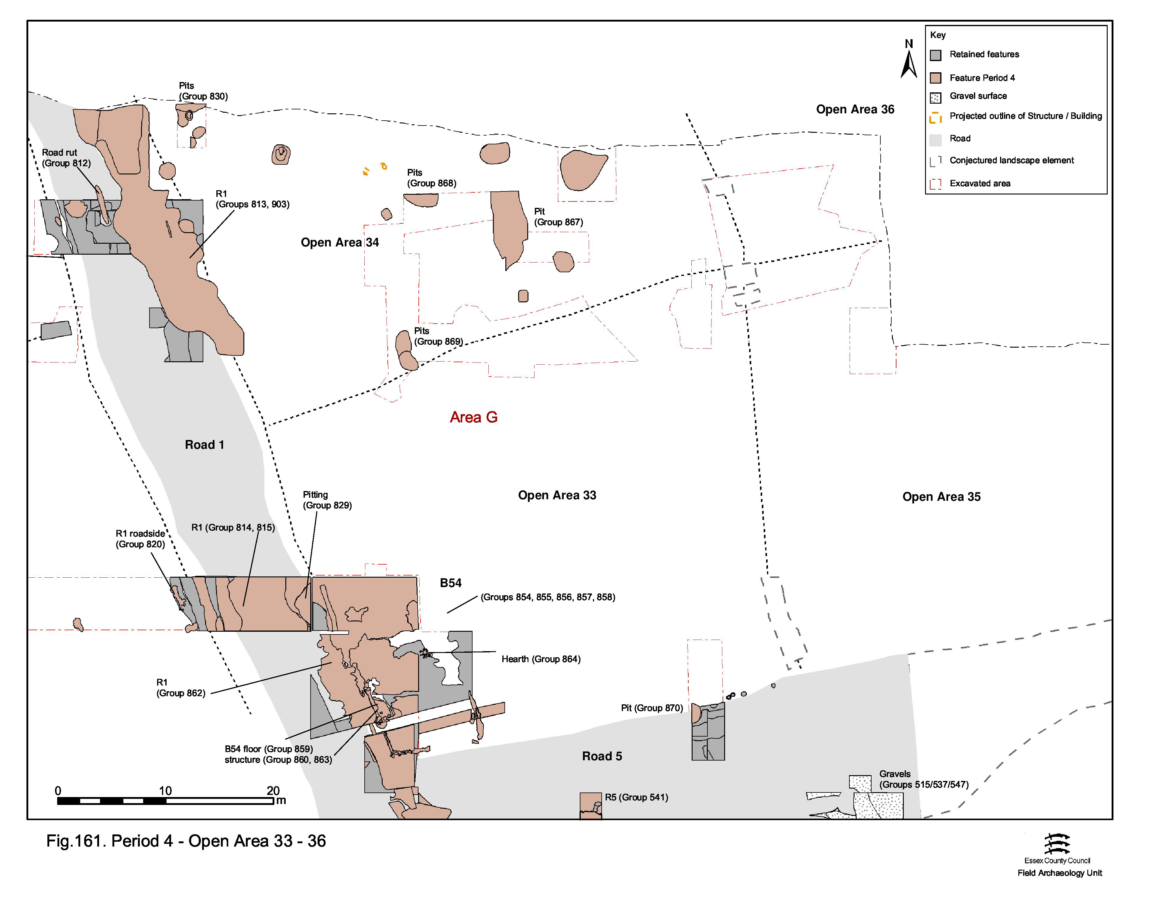
The clearest and most tangible sign of occupation within the Northern Zone enclosures east of Road 1 is provided by the construction, probably in the late 2nd or early 3rd century, of large, rectilinear, timber-framed Building 54, alongside the junction of Roads 1 and 5 and perhaps therefore within the continuance of OA33. This building may take advantage of the firm level surface provided here by gravel surfacing laid down in Period 3. Building 54 is subsequently extended westwards, by the addition of what may be a portico or veranda that encroaches onto the adjacent surface of Road 1, though the full width of the road appears to be restored when the veranda passes out of use.

Building 54 comprises the burnt and partially cleared remains of the structure, set on a sequence of late 2nd-early 3rd century make-ups (Group 854) (Figure 162). The position of its east, west and part of the south external walls are principally marked by a foundation slot 25219/25220 (Group 855), though its north wall is not identified. The slot is filled with burnt daub fragments, much of which bears wattle and roller stamp impressions, used as deliberate packing (Figure 142). This material must derived from a separate (and earlier) building, which also presumably burnt down. Post-holes (Group 856) and stake-holes 7580 (Group 860), 7610, 7611 (Group 858) are set at intervals into the wall slot and its daub packing, and some contain the bases of carbonised stakes. A 'foundation offering' deposit of a complete ceramic vessel is placed within the west wall foundation.

Together, these structural features define a building that is 9m wide and at least 10.5m long, but probably significantly longer. Within the recorded extent of Building 54 are the remains of a beaten brickearth floor surface or at least the preparation for a more solid surface (7472/7572 Group 857), but there are few other discernible features denoting such things as partition walls. However, tile-lined hearth 7544 (Group 864) may well be contemporary.
Cut into the Road 1 surfaces in front of Building 54, slots 7529 and 7648 and post-holes 7538, 7547 (Group 863), together with post-hole 7702 (Group 860), may define a porch or veranda. This seems to be an addition to the front of the building and to encroach upon the Road 1 surface. Slot 7529 includes at least two post-holes and may indicate the location of the doorway into Building 54, perhaps representing a foundation for the threshold and door lintels. Gravel deposit 7736 (Group 859) may constitute the floor surface within this western extension.
Pit 10271 (Group 829), lying between Building 54 and Road 1, is dated to the mid-2nd to mid-3rd centuries AD. It partly cuts through a Road 1 surface (Group 815, see above) and could be contemporary with the use of Building 54.
Building 54 passes out of use towards the end of Period 4, around the mid-3rd century AD - presumably the point at which it is destroyed by fire. Its site is subsequently sealed by debris (Group 865). The porch/veranda features, and the west wall of Building 54, are subsequently overlain by resurfacing of Road 1 (Group 862/86, see above). The building is therefore probably in use only for a relatively short period of time between the late 2nd and mid-3rd centuries AD.
Little else was excavated in OA33 beyond the immediate vicinity of Building 54 itself and virtually nothing else can be discerned about the use of its interior during Period 4. Away from Building 54, the only feature of this date to be investigated is solitary pit 7441 (Group 870), which lies 18m to the east of Building 54 and encroaches upon Road 5. Unexcavated and undated hearth remains lie to the north of the building and could be associated with its occupation.
Mid-Roman pits are relatively numerous across OA34 (Figure 162) - although their absence elsewhere perhaps largely results from lack of excavation. Where investigated, they generally contain material indicative of occupation of a domestic character. A cluster of small pits (Group 830) in the north-west of the enclosure contain few finds, while those further east (Group 868) contain a little more material but the finds assemblages are not particularly diverse, largely comprising pottery and tile. A low incidence of metalwork is notable. Pit 7122 contains a large pottery assemblage (KPG25, AD170-200), while 7072 is notable for its animal bone, though these are probably just specific dumps rather than an indication of specialised pit use. The Group 869 pits may lie on the line of the boundary between OA33 and OA34 - though without knowing the true nature of the deposition of pits across both enclosures, it is difficult to determine whether or not this is significant.
The terminal of a substantial north-south aligned ditch (Group 867) lies among the Group 868 pits. It is presumed to extend off perhaps as far north as the watercourse. It does not appear to run parallel with the Road 1 alignment, but could possibly represent a subdivision of OA34, or even a replacement of some or all of the previous land divisions of this part of the Northern Zone during Period 4. The ditch fills during the mid- to late 3rd century AD.
There is nothing of Period 4 date (Figure 162) in either OA35 or the south-west corner of OA36 (i.e. those parts investigated within Excavation Area G). At the north-east investigated extent of OA36 (in Excavation Area R to the south of the river channel), Period 3 well 12245 falls out of use by the later 2nd century and is subsequently sealed by extensive gravelly dumps (Group 977). The dumps are not reliably dated, but may be contemporary with an episode of mid-Roman deposition and change of use on the opposite bank of the river channel (Group 966, below).
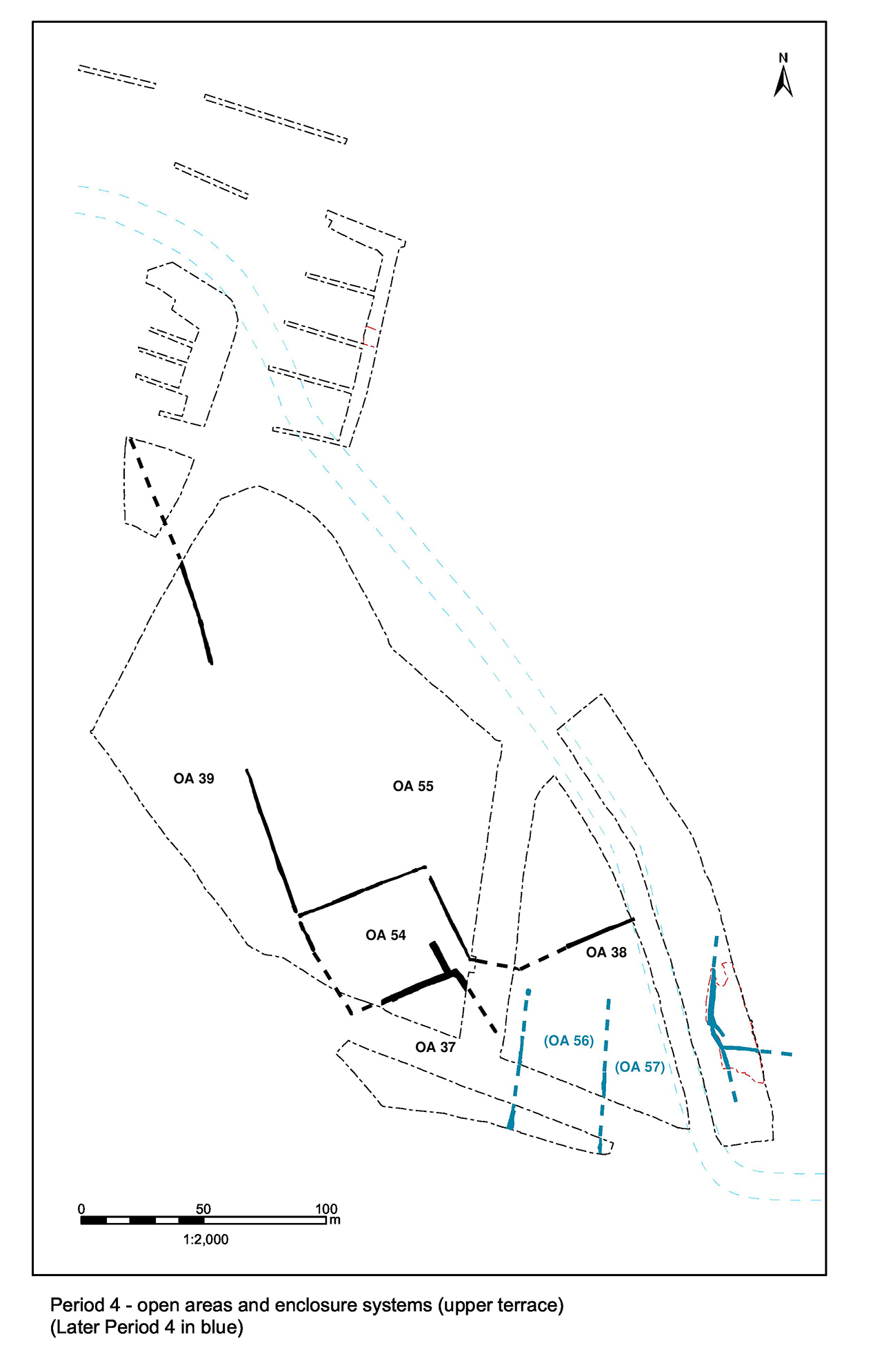
In the northern hinterland, the creation of the gap in the boundary between Open Areas 39 and 40/41 (ditch 25103 re-cuts Group 892) at the end of Period 3 only seems to be the start of widespread modification of the field system, much of which is apparently carried out at the beginning of the 3rd century, with secondary developments a short time after.
It is conjectured that the boundary between OAs 40 and 41 (if there ever was one) passes out of use as a result of the creation of the wide gap in ditch 25103. With no replacement or alternative subdivision evident, it is assumed that these fields become a single entity and are hereafter referred to as Open Area 55.
A smaller, square, enclosure is subsequently inserted into the south-west corner of what is now OA55, incorporating the extant parts of ditches 25103 and 25194 into its southern and western boundaries, new ditches forming its northern and eastern sides (25104, 25193 Group 895, 25198 Group 896). This new enclosure, Open Area 54, features a funnel-like entrance at its south-east corner, which suggests that it functions as a livestock enclosure and may indicate increased pastoral farming during this period.
The creation of OA54 and its funnel entrance necessitates the modification of the Period 3 'junction' between OAs 37, 38 and 40. It is likely that the boundary between Open Areas 38 and 53, previously defined by ditch 25273, is reworked at this time. Although broadly retained, it becomes becomes largely infilled by the mid-Roman period. The ditch is seemingly partially re-cut, shortening its westward extent so as to make way for OA54's entrance and leaving a relatively wide point of access between OAs 48 and 53. It is unclear whether the southward leg of ditch 25194 is affected. It could persist, with pottery kilns 1223 and 1618 being positioned alongside, until shortened to make way for another revision of the boundary system along the southern edge of the northern hinterland zone, in the latter part of Period 4.
Either occupying or more realistically replacing OA38, a series of three parallel minor ditches (Group 912), running nearly north-south, define a series of strip plots. It is conjectured that they likely extend eastwards along the north bank of the watercourse, at least as far as Road 1, and to constitute a later phase of landscape change in Period 4. One of the delineating ditches (25106) post-dates kiln 1223, which would imply that the new boundary system dates no earlier than the first half of the 3rd century AD. The two western ditches (25101, 25106) are approximately 35m apart and similar in shape and size. Both slope down to the south and may function as drains. A cross-ditch (25191 Group 891) runs between them and two pits (Group 915) are sited at the junctions of the ditches. The third ditch, 25189, lies some 45-50m further east. A gap in this ditch provides an entrance, flanked on its southern side by a minor east-west ditch (48), which seems to subdivide the eastward plot interior.
Other than the creation of the wide gap in its eastern boundary, OA39 endures unchanged and without any features in Period 4 (Figure 163). It is assumed that this reflects an exclusively agricultural use.

While the creation of OA54 may be interpreted as indicating increased pastoralism, arable farming clearly remains important (Figure 163). Two drying structures 3042 and 2647 are constructed close to each of the terminals of the gap in ditch 25103, their presence indicating that at least some of the initial crop processing, most likely of cereals, is being carried out in the fields rather than the settlement itself. Both date to the mid-2nd to mid-3rd centuries AD and are presumed to be broadly contemporary, though clear differences in their form are noted. The southern structure seems to pass out of use first, while its northern counterpart may continue to be used, albeit intermittently, for longer.
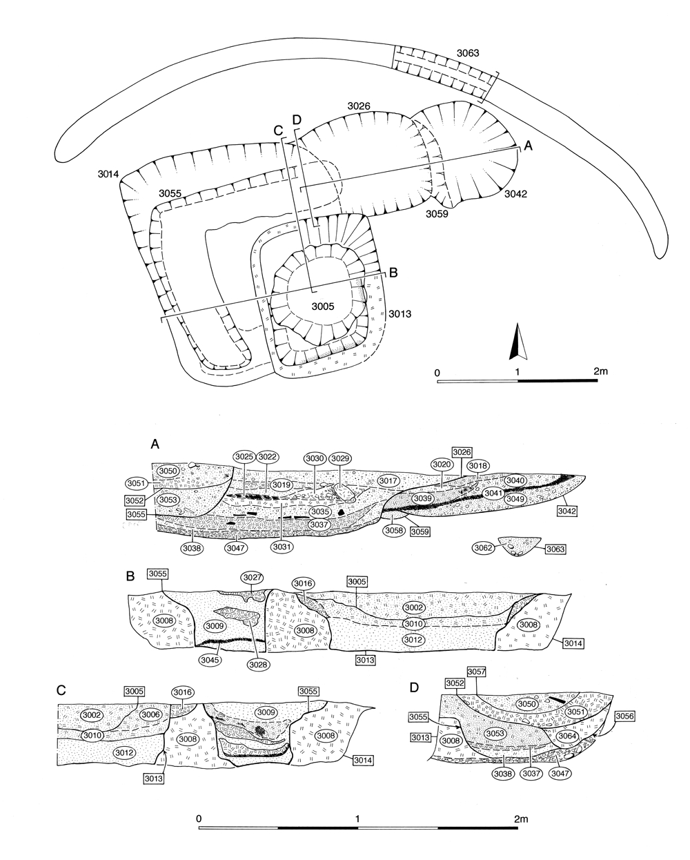
Northernmost drying floor 3014 (Groups 916, 917) comprises the remains of a square foundation incorporating under-floor vents or flues fed by an integral stoke-hole or fire pit (Figure 164). Close parallels are to be found in corn-dryers 4 and 5 at Foxholes Farm in Hertfordshire (Partridge 1989, 36-40). Two, possibly three, major phases of remodelling of the structure are evident (Groups 918/919, 920/927, 924). A curved gully (3063 Group 979) to the north of drying floor 1 marks the position of either a wind-break fence or drainage to prevent water running into the flues.
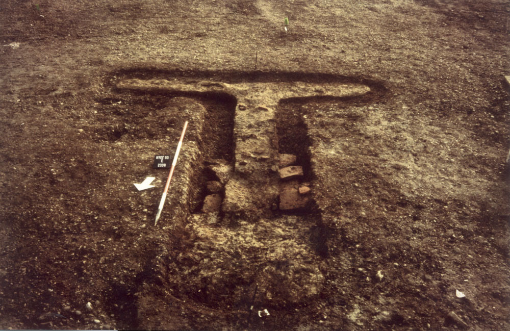
The southern drying floor 2338 (Group 929) comprises a T-shaped tile-built foundation lined with clay (Figures 143 and 165) defining the below-ground flue beneath a more extensive drying floor, with slight remains of a stoke-hole at its north end. Disuse deposits (Group 930) signify its abandonment and robbing.

No other Period 4 features are evident elsewhere within OA53. Like adjacent OA39, it is presumed to function exclusively as an arable field.
Broad, shallow, ditch 25206 (Group 897), located just inside the funnel-like entrance, could be regarded as an integral part of the part of the enclosure system (Figure 163). It presumably forms a passage or holding area and suggests livestock control. Only two small pits (Group 914) occupy the enclosure interior; pit 2329 appears to be centrally positioned and could mark the position of something like a tethering post. Toward its south-west corner, a line of post-holes (Structure 50 Group 931) might represent part of a fenced subdivision such as an animal pen. Although undated, they share an alignment with the enclosure boundary and could therefore be contemporary.
Open Area 37, perched on the edge of the upper terrace, seems to retain its marginal status, along with OA 38 (Figure 163). It contains only a small number of pits (Group 913) of mid-2nd to mid-3rd century AD date, all but one of which are positioned on or at the foot of the terrace step.
Alongside OA37, OA38 appears to have a low level of use, as it does in previous periods (Figure 163). Its marginal position and status between cultivated fields and the settlement is emphasised by the location of mid-Roman manufacturing activity within it. A pair of Wattisfield-type (East Anglian) circular pottery kilns (Swan 1984 , 77, 115-16) are constructed, probably in the early 3rd century AD, to the south of the funnel entrance of OA54 and against the western boundary of OA38. Perhaps more importantly, the kilns are presumably sited in proximity to convenient sources of clay, fuel and water. Both kilns are single-chambered and single-flued, with integral 'bollard'-type pedestals (Figure 144).
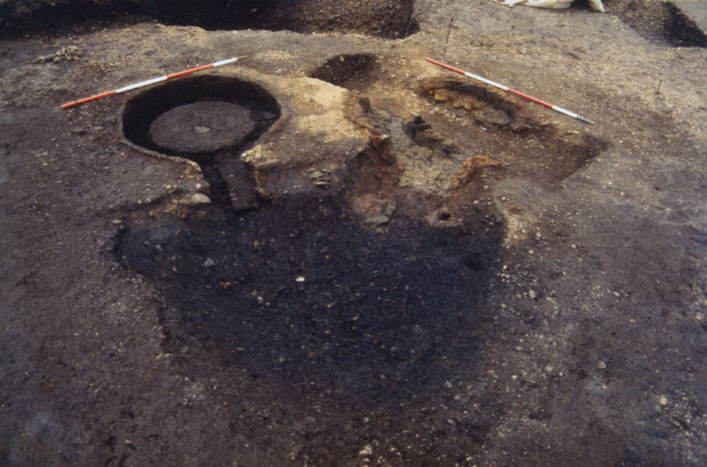
Kiln 1618 (Group 906) includes a number of stake-holes positioned outside the kiln wall, indicating the presence of a domed clay superstructure supported by a framework of poles. The kiln floor is overlain by a thin charcoal-rich use deposit, although the majority of the layers within the structure appear to be collapsed clay superstructure and clearly related to its disuse (Group 907).
Kiln 1223 (Group 908), although truncated by later ditch 25106 (Group 912), is of more substantial construction. The internal surface of the thick chamber wall is heavily vitrified and repair is evident to the kiln flue floor. Fine charcoal-rich silts lie within the kiln chamber and thin out towards the flue. Above these are silty backfill deposits (Group 909) which, like the disuse deposits of Kiln 5, include large quantities of fired clay debris.
The large stoke-hole 1589 (Group 910) that lies between the kilns is integral to both. It was lined by charcoal-rich rake-out deposits, overlain by silty disuse deposits (Group 911) that once again contain the distinctive fragments of collapsed superstructure, along with a number of fire-bar fragments.
As the kilns share a single stoke-hole, they are probably in use together rather than consecutively. However, the distinct differences in construction and intensity of use may suggest that they have subtly differing functions within the process. Further consideration of both kiln use and products is presented in the pottery report.
Pottery incorporated into the structure of kiln 1618 provides a late 2nd century terminus post quem for its construction. Archaeomagnetic dating provides dates of AD 140-170 and AD 90-210 for the last firing of kilns 1618 and 1223 respectively. Pottery collected from the use/disuse deposits from both kilns suggest that their use ceases in the early 3rd century, though perhaps kiln 1618 is not infilled until longer-lived kiln 1223 passes out of use.
As noted to be the case in OA37, pitting of mid-2nd to mid-3rd century AD date in Open Area 38 (Group 982) is restricted to a small number positioned on the terrace step edge. This seems to continue after this land unit is replaced by the new strip plots (OAs 56 and 57) that are set out along the southern edge of the northern zone. Late Period 4 pits (Group 915) are apparently located at the southern terminals of the strip plots' boundary ditches.
In that part of the northern hinterland alongside the river channel (where investigated in Excavation Area R), mid-Roman activity is primarily limited to deposition (Figure 166). Dumping (Group 966) seals the abandoned Period 3 cremation cemetery and apparently fills/levels the base of a part-cellared structure (12061/12371 Group 978) that is located on the north bank immediately adjacent to the watercourse. In contrast to the earlier dumps along the north bank, this episode includes the deposition of relatively substantial quantities of building rubble and charcoal-rich waste, which may hint at the demolition and clearance of a substantial building in the vicinity during the early to mid-3rd century AD, perhaps following its destruction by fire. These rubble dumps are subsequently levelled off with further widespread dumps of gravelly silts, with far lower finds densities, which perhaps represents the reconstitution/remediation of the land surface. This sequence is paralleled at the Crescent Road site (Wickenden 1986, 13-15) immediately to the north. There is no suggestion that the area is used as a cemetery at all in Period 4. Instead, a distinct change in land-use is signalled by the Period 4 remains that post-date the dump sequence.
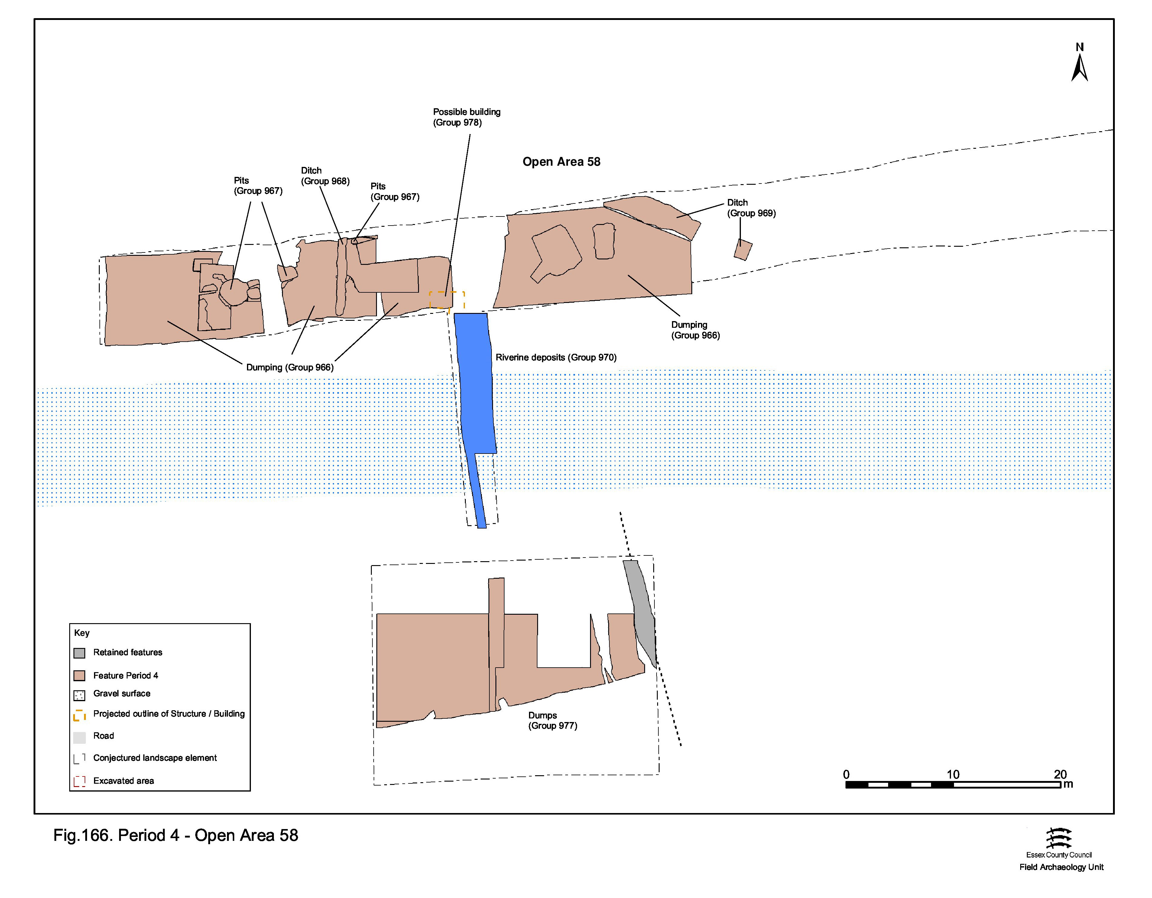
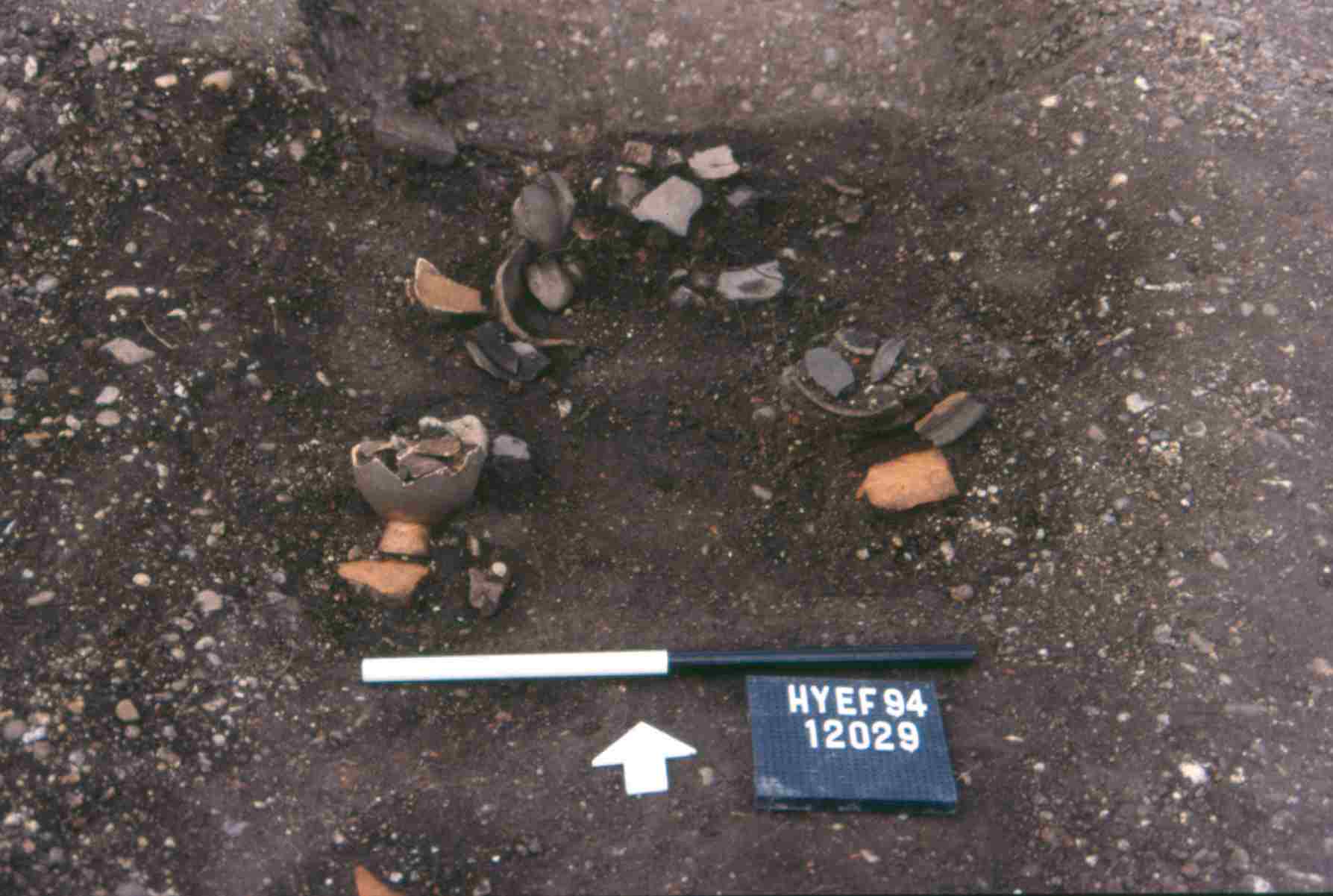
The presence of shallow north-south boundary ditch 12027 (Group 968) may indicate that the reconstituted north bank is now newly subdivided, perhaps into regular plots. It is possible that this equates with the imposition of strip plots along the upper terrace edge further west (OA56, above). Probably dug in the mid- to late 3rd century, this ditch continues to accumulate material as late as the 4th century. Its southern terminal contains a cluster of complete vessels (Figure 145), along with large amounts of tile, iron objects and glass fragments; some of which show signs of careful placement.
If indeed structural, rectangular cut 12061/12371 (Group 978), mentioned above, indicates the presence of a building immediately east of ditch 12027. While there is some ambiguity as to its precise relationship with the dump deposits, its alignment on the ditch and on the edge of the watercourse may suggest this is indeed part of a mid-Roman structure occupying the reconstituted land surface of the north bank.
A small number of pits (Group 967), also cutting the Period 4 dump deposits, are predominantly located west of ditch 12027, perhaps deliberately separated from the tentative building. As is generally the case across the settlement, these 3rd century pits contain large assemblages of pottery and tile in relation to feature size.
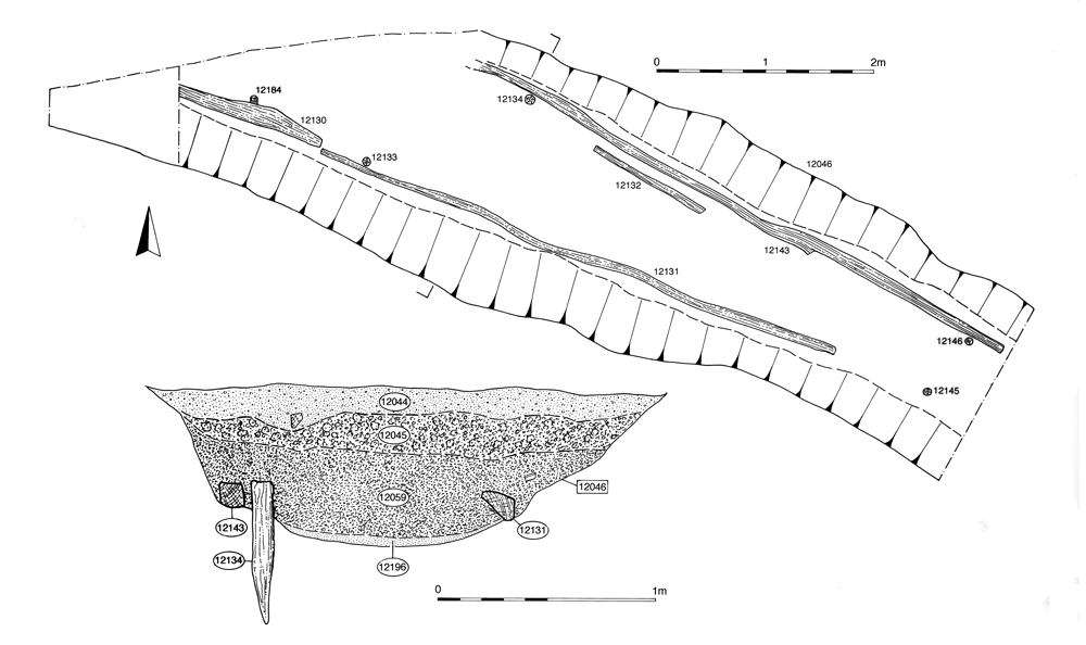
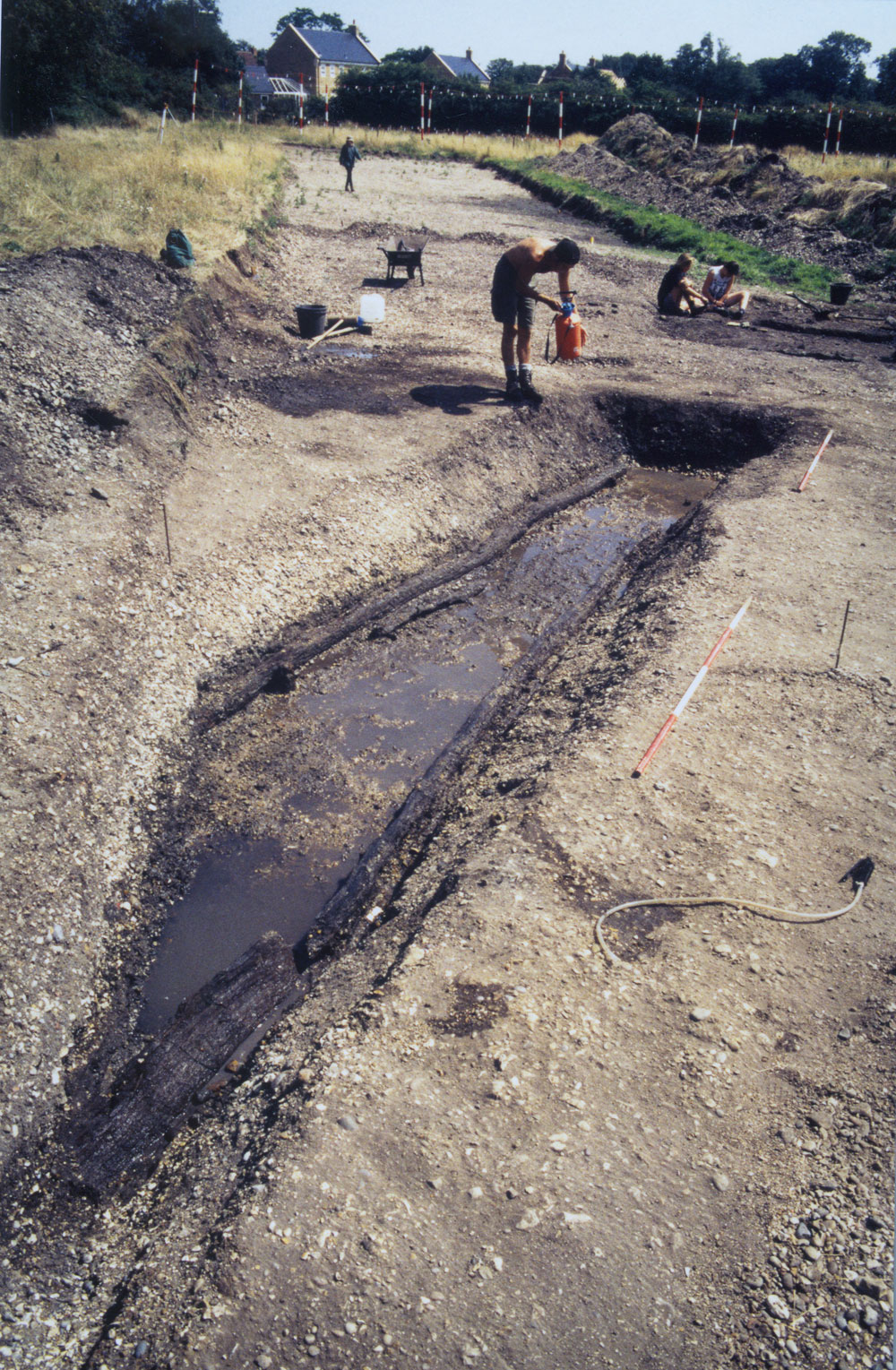
Further east, substantial wood-lined ditch 25271 (Group 969) runs on a north-west/south-east alignment, presumably draining into the watercourse a short distance to its south (Figure 167). Remains of revetting (Figure 146) along its sides indicate that it must be a major drain, or even a channel in its own right, carrying an appreciable flow of water into the river channel proper. It may even be possible to speculate that it constitutes a leat that cuts across a corner/bend of the watercourse - if so, its imposition could be a contributing factor to its rapid silting-up observed to the west (see below). The timber lining has produced a dendrochronological date of AD 215-251, pointing to its construction in the mid-3rd century. Dating evidence from the fills demonstrates that the ditch is kept clear for a considerable period of time, not accumulating material until the 4th and 5th centuries. Whether or not this revetted ditch constitutes the out-shot of a mill or water supply/drainage for a bath-house (associated with a villa?) located to the north or north-west can only be a matter for conjecture.
Within the watercourse, alongside OA58, the majority of the silts exposed are of 3rd century date. Although the full fill sequence was not established, it seems that mid-Roman deposits constitute the majority of the fills within the palaeochannel. If so, this suggests that the watercourse is allowed to silt up with little attempt maintain its flow. Within this silting sequence are brick and tile dumps similar to those to the north and it is clear that build-up within the channel is contemporary with dumping and levelling on the land surface. The sequence comprises grey clays separated by thin layers of sand, which become more complex and intermixed at the centre of the channel (Group 970). The development of the silting suggests a shift of the main current toward the south bank through the 3rd century and it seems that the channel becomes more-or-less completely infilled by the end of the period. Environmental evidence suggests that the channel is by now only intermittently active - perhaps seasonally.
In the extreme east of the excavated area, activity is sparse and difficult to interpret (Figure 134). It is likely that this reflects a genuine paucity of activity in this part of the site during Period 4 - associated with but perhaps more pronounced than that seen in the Southern Zone. Indeed, there is unlikely to be any tangible separation or differentiation of land use between the two zones. The ditches of preceding periods are by now infilled and seem no longer to exert any recognisable influence.
Fragmentary and variable clayey silt deposits (Group 951) may constitute the remains of a soil that develops across the eastern hinterland from the early 3rd century AD onwards. It is possible that this eastern periphery is given over to purely agricultural uses. Structural features that can be dated to Period 4 (Group 949) are scattered and lack any patterning. A slot (Structure 49 Group 950) with stake-holes in its base lies on a differing alignment. An adjacent pit (Group 948) may also simply be a large post-hole, though the size and range of its finds assemblage suggests otherwise.
Internet Archaeology is an open access journal based in the Department of Archaeology, University of York. Except where otherwise noted, content from this work may be used under the terms of the Creative Commons Attribution 3.0 (CC BY) Unported licence, which permits unrestricted use, distribution, and reproduction in any medium, provided that attribution to the author(s), the title of the work, the Internet Archaeology journal and the relevant URL/DOI are given.
Terms and Conditions | Legal Statements | Privacy Policy | Cookies Policy | Citing Internet Archaeology
Internet Archaeology content is preserved for the long term with the Archaeology Data Service (ROR). Help sustain and support open access publication by donating to our Open Access Archaeology Fund.
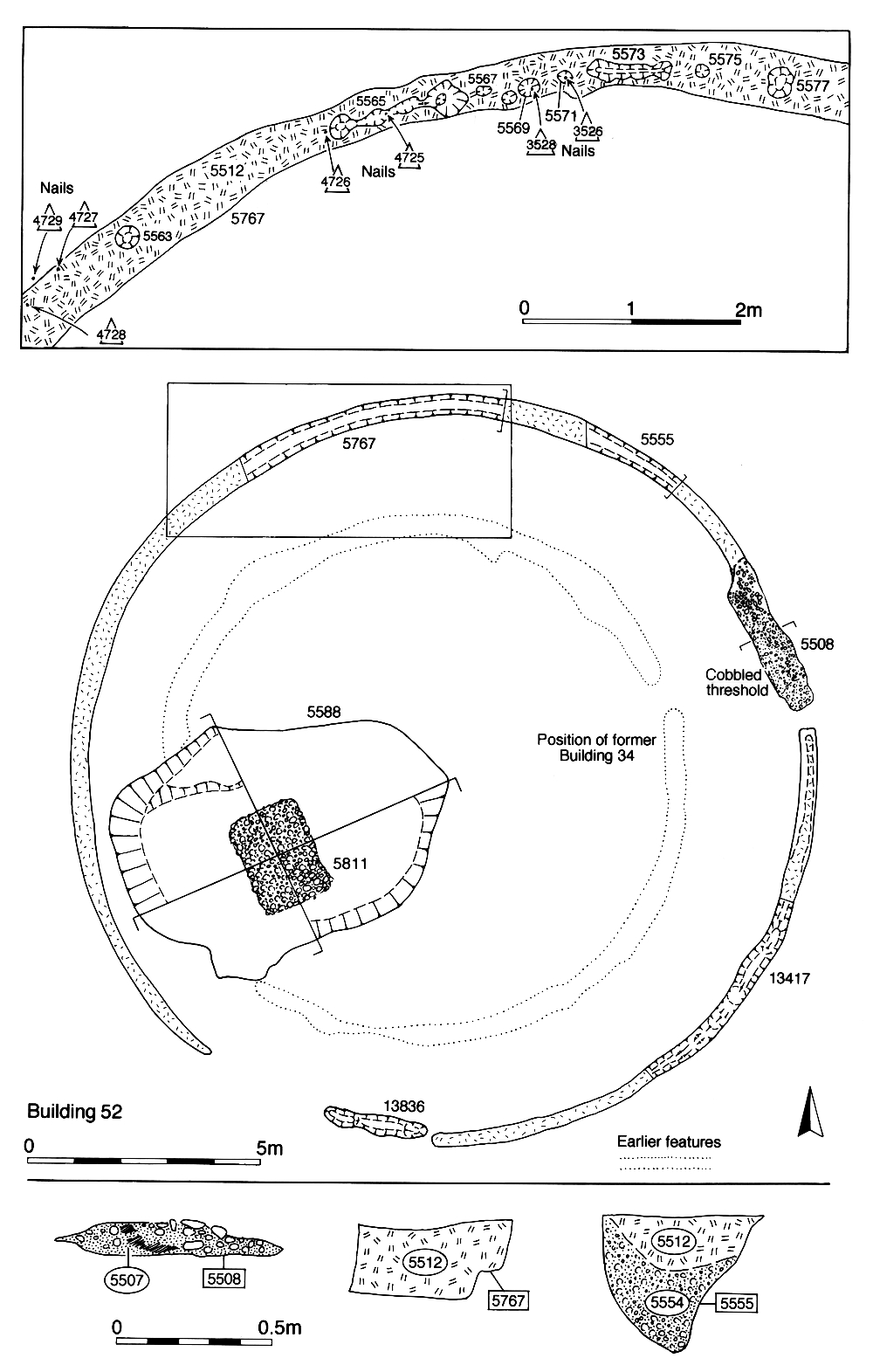
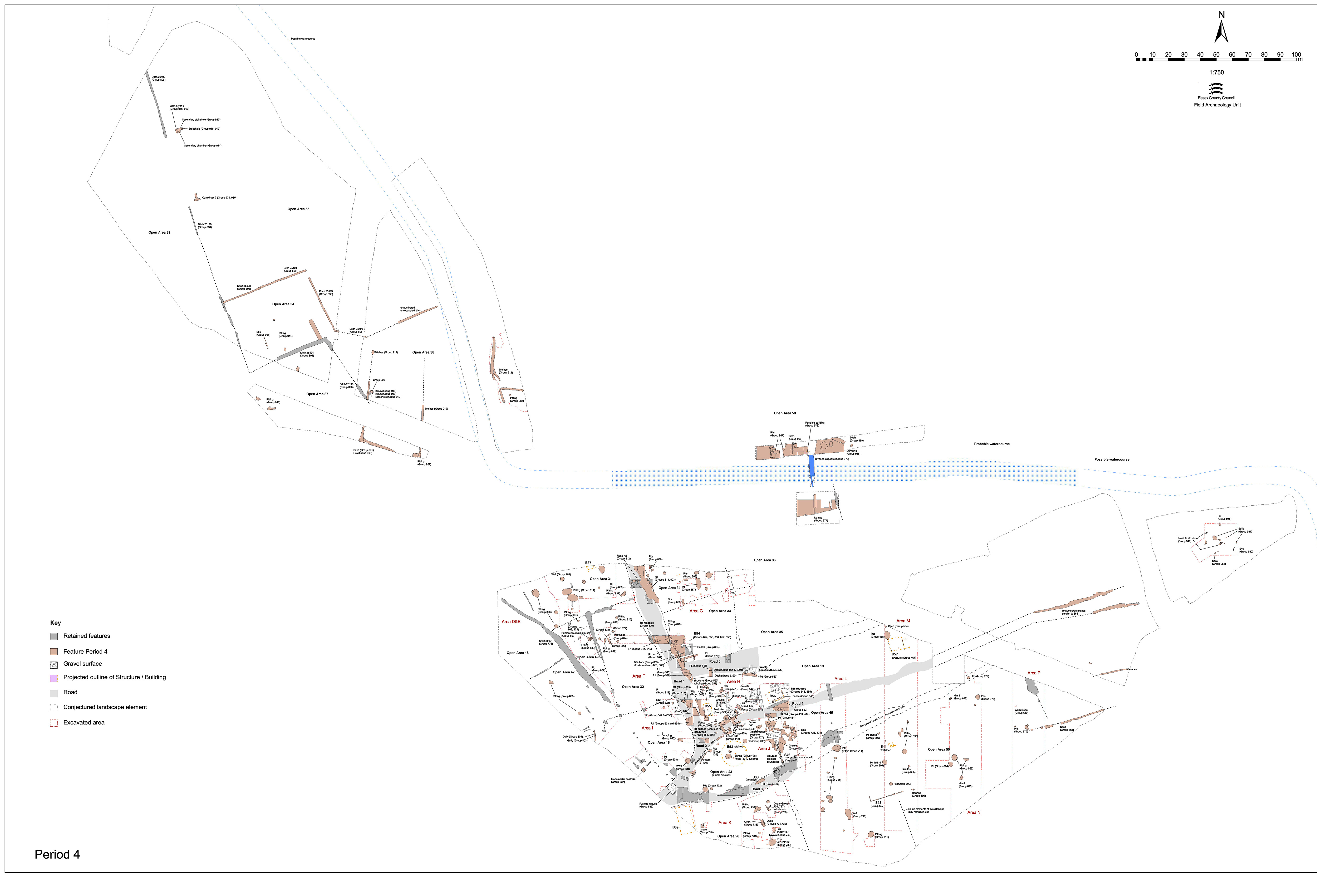
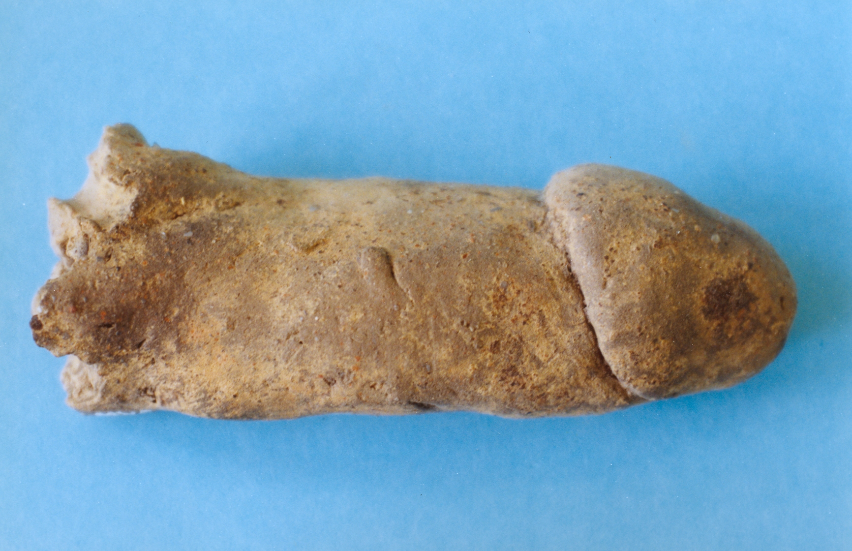