
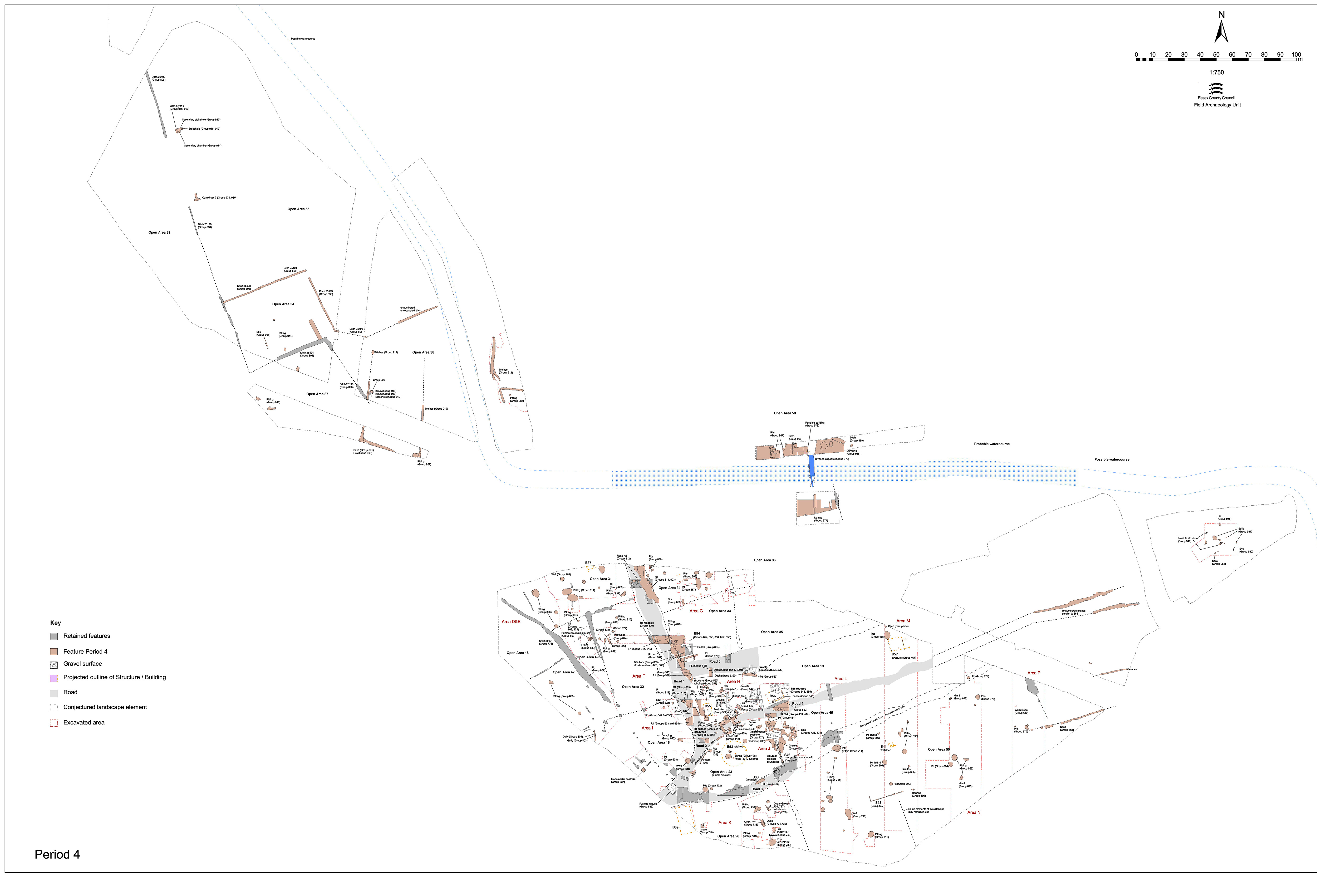
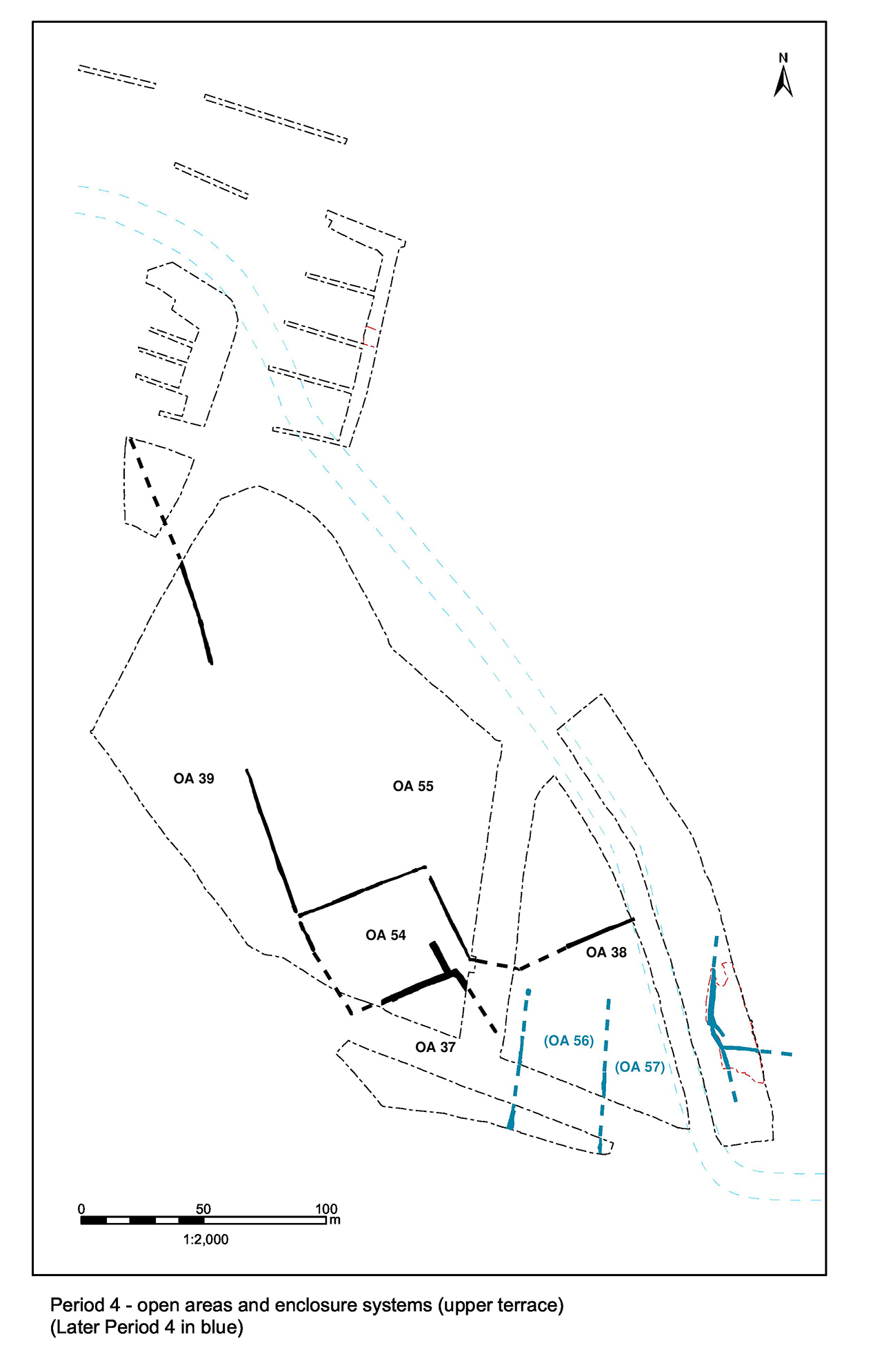
Much of the modifications to the Northern hinterland landscape earlier in Period 4 endure into the latter part (i.e. first half of the 3rd century), the further changes all taking place along its southern margin, just above the terrace step (Figure 163). The pottery kilns pass out of use and a new series of apparent strip enclosures are inserted within what is formerly Open Area 38, perhaps within the existing layout, but on a markedly differing alignment.
The only new land divisions to be created in the mid-Roman period are a series of three minor parallel ditches 25101, 25106 and 25189 (Group 912) that subdivide what is formerly the OA38 interior and seem to extend further east. Running on a near north-to-south alignment, they subdivide the land immediately north of the edge of the gravel terrace. Most significantly, their alignment is a clear departure from that of all earlier boundaries.
Ditches 25101 (segs 539, 3547) and 25106 (segs 447, 529, 634, 3684, 3782) are approximately 35m apart and similar in shape and size. Both slope down to the south and probably perform a drainage function. Ditch 25106 post-dates kiln 1223, being cut through its by now obsolete chamber. Ditch or slot 25191 (Group 891) runs east-west between the southern ends of the two ditches, but lies too close to the limit of excavation for its implications to be understood. However, it remains possible that it marks the southern boundary of these strip enclosures.
The imposition of this new set of ditches appears to date to some time in the first half of the 3rd century AD, after the kilns pass out of use. Although the land entities defined by these ditches are accorded the labels of OA56 and OA57, it seems that they rather constitute sub-enclosures within OA38. It is notable that both run near-perpendicular to the southern part of ditch 25193, which forms the splayed entrance to OA54. Furthermore, the northward line of 25106 can be surmised to head toward the ditch 25193 terminal.
The third north-south boundary 25189 (segs 048, 094), some 45-50m further east, is of two phases; ditch 25189 being replaced by more substantial ditch 25187. Both phases have an entrance gap within their lengths and minor ditch 048 runs off eastwards at right angles to form the south side of an entrance or to subdivide the eastward plot interior. Neither end of this ditch sequence was located, but it serves to indicate that further enclosures lay eastward along the terrace edge to the north of the watercourse. This ditch is technically located on the opposite side of the postulated northward course of the watercourse and could therefore constitute a separate strip enclosure system along the terrace-edge/north bank of the watercourse. However, as it shares an alignment with 25101 and 25106, it is in some ways best described here. It may be the case that this enclosure system indeed straddles the watercourse, but only extends east as far as Road 1.
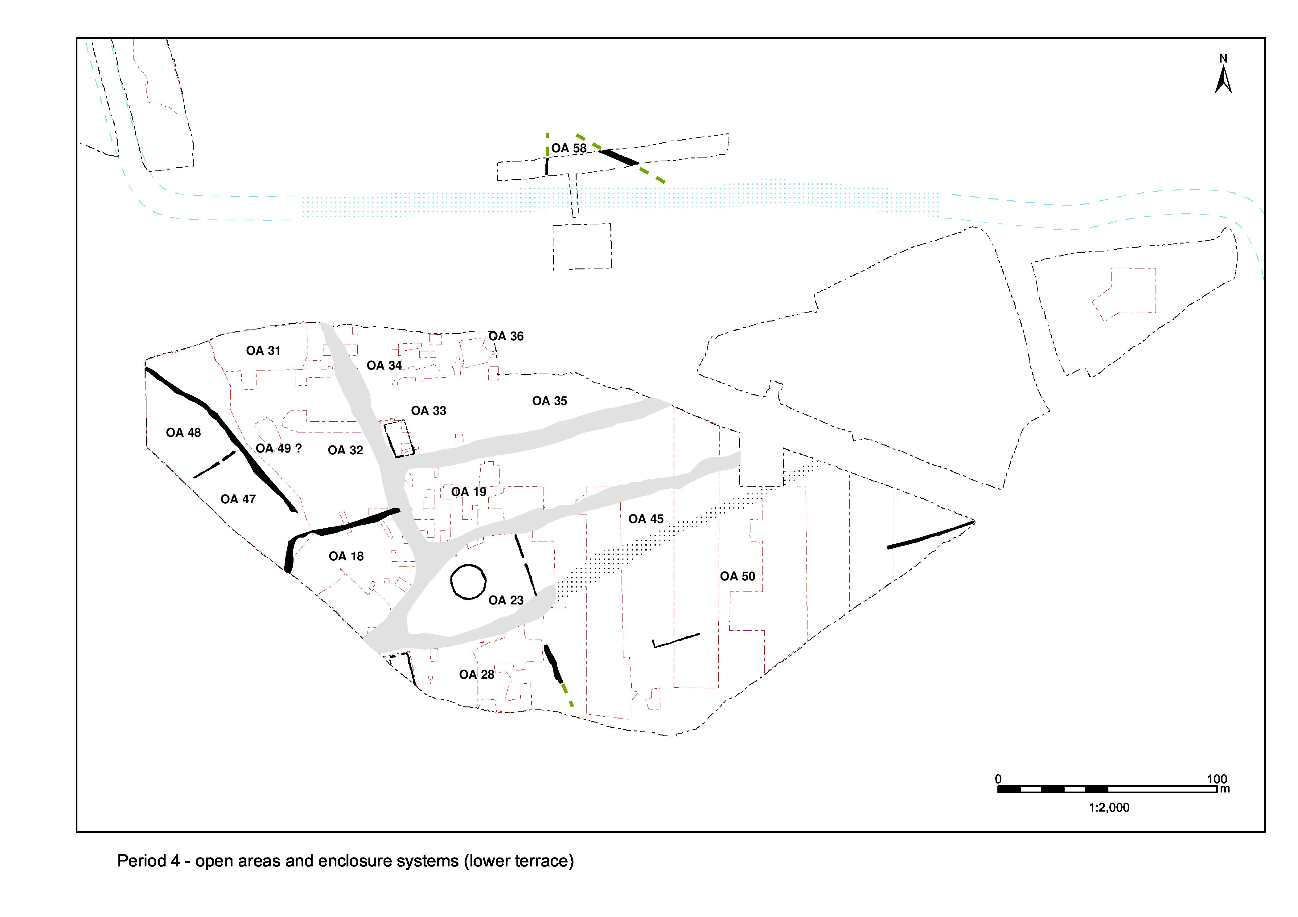
Within newly formed OA56, there are no Period 4 features other than a few pits located near or on its boundaries (Figure 163). A livestock enclosure function, perhaps associated with OA54, may be speculated; though admittedly little of its interior is investigated due to the presence of a sterile masking silt deposit. No features are identified within the OA57 interior.
Period 4 pits 3557 and 3796 (Group 915) notably lie at the south ends of boundaries 25101 and 25106, at their junctions with poorly understood ditch 25191. It is possible that these pits are deliberately located on this posited southern boundary and at the ends of the north-south ditches. While pit 3796 contains only a modest assemblage of pottery, tile and baked clay, 3557 includes a large, residual Late Iron Age pottery assemblage. Its stratigraphic relationships and presence of a radiate coin (SF168) confirm the mid-Roman date of the pit, the earlier material probably deriving from the mainly LIA features into which it was cut.
No substantive change is discerned to the extents of OA55, its western and southern boundaries being assumed to endure throughout Period 4 and perhaps beyond (Figure 163). However, alterations are made to the crop-processing structures earlier placed along its western edge.
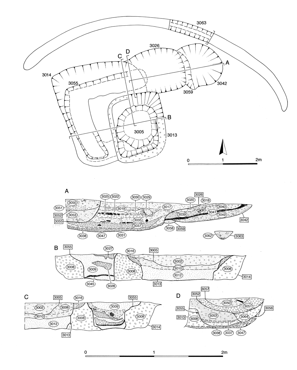
Drying floor 3014 (Figure 164) probably passes out of use in the early to mid-3rd century. Chamber 3013 (Group 924) is filled with fired clay debris (Group 925). Within stoke-hole 3026, tile (Group 921) is dumped on top of charcoal-rich use accumulations (Group 920) and then infilled with silt and capped with clay (Group 921). Above this clay, a series of further deposits, containing burnt material and fired clay fragments (3025, 3029 Group 922), seem to indicate a second period of use followed by disuse and infilling in the form of gravelly brown sand-silts and clean clays (3017, 3019, 3021, 3022, 3030 Group 923).
A circular pit 3005 (Group 926) is deliberately positioned upon and dug into the infilled remains of chamber 3013. Measuring c. 1.25m in diameter, it occupies as much of the former chamber interior as possible. Although its clay fill contains charcoal and fired clay debris, it is not clear whether it represents an adaptation to a still-functioning drying structure or a distinct and separate pit that simply fortuitously uses the dryer remains.
As previously noted, when drying-floor 2338 passes out of use the majority of the below-ground tile-built component of the structure is robbed, as evidenced by empty 'slot' 2647 around the perimeter of the structure, which is then backfilled with silt and tile fragments derived from this robbing activity (Group 930).
Internet Archaeology is an open access journal based in the Department of Archaeology, University of York. Except where otherwise noted, content from this work may be used under the terms of the Creative Commons Attribution 3.0 (CC BY) Unported licence, which permits unrestricted use, distribution, and reproduction in any medium, provided that attribution to the author(s), the title of the work, the Internet Archaeology journal and the relevant URL/DOI are given.
Terms and Conditions | Legal Statements | Privacy Policy | Cookies Policy | Citing Internet Archaeology
Internet Archaeology content is preserved for the long term with the Archaeology Data Service (ROR). Help sustain and support open access publication by donating to our Open Access Archaeology Fund.