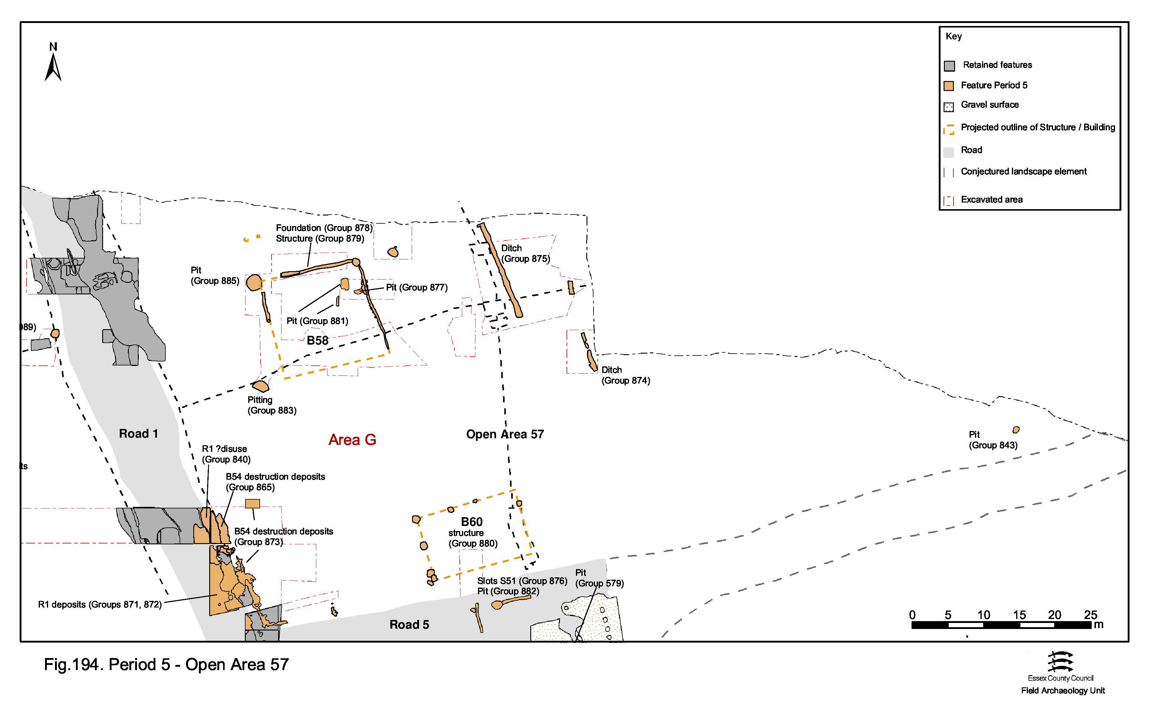
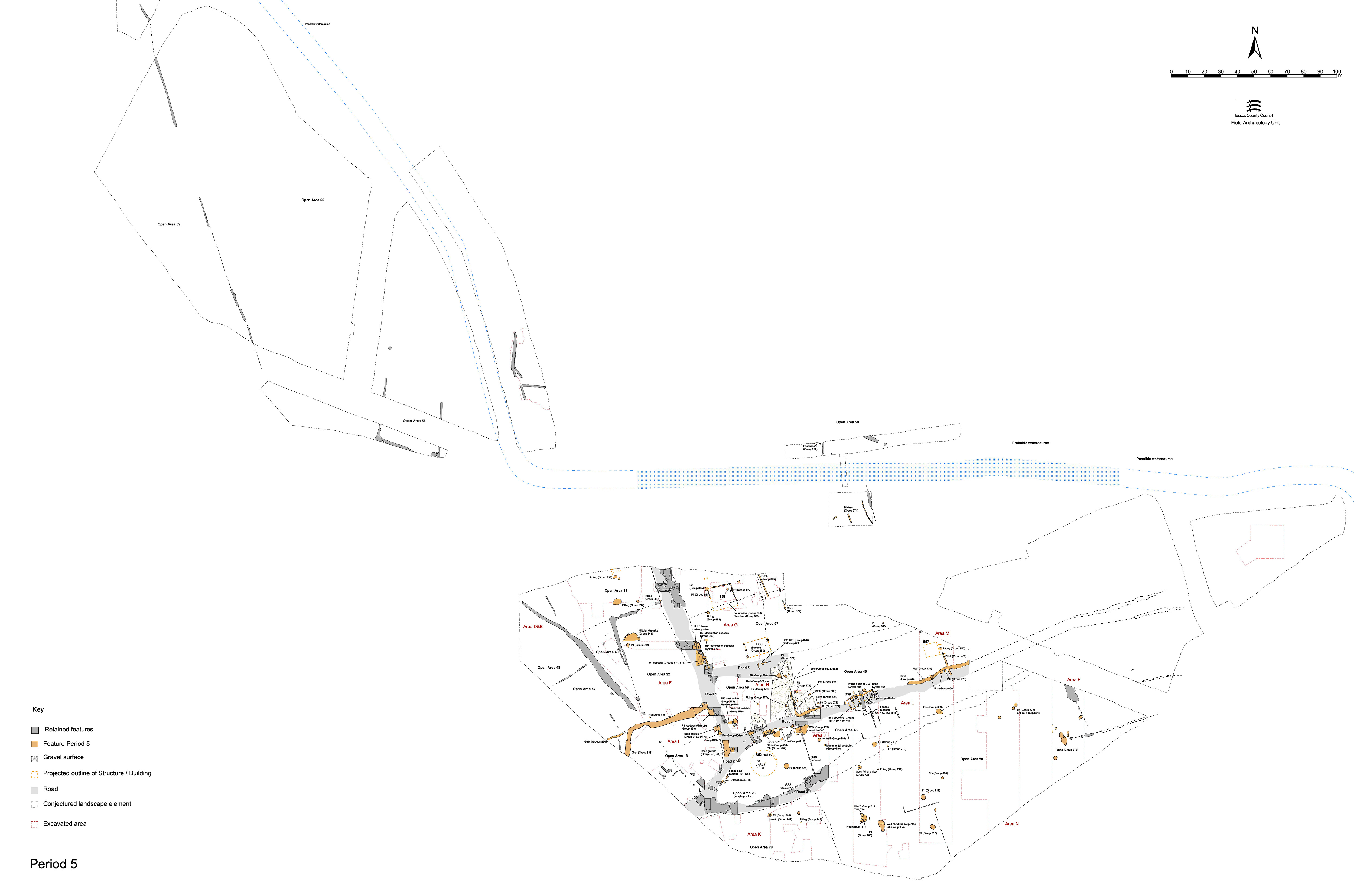
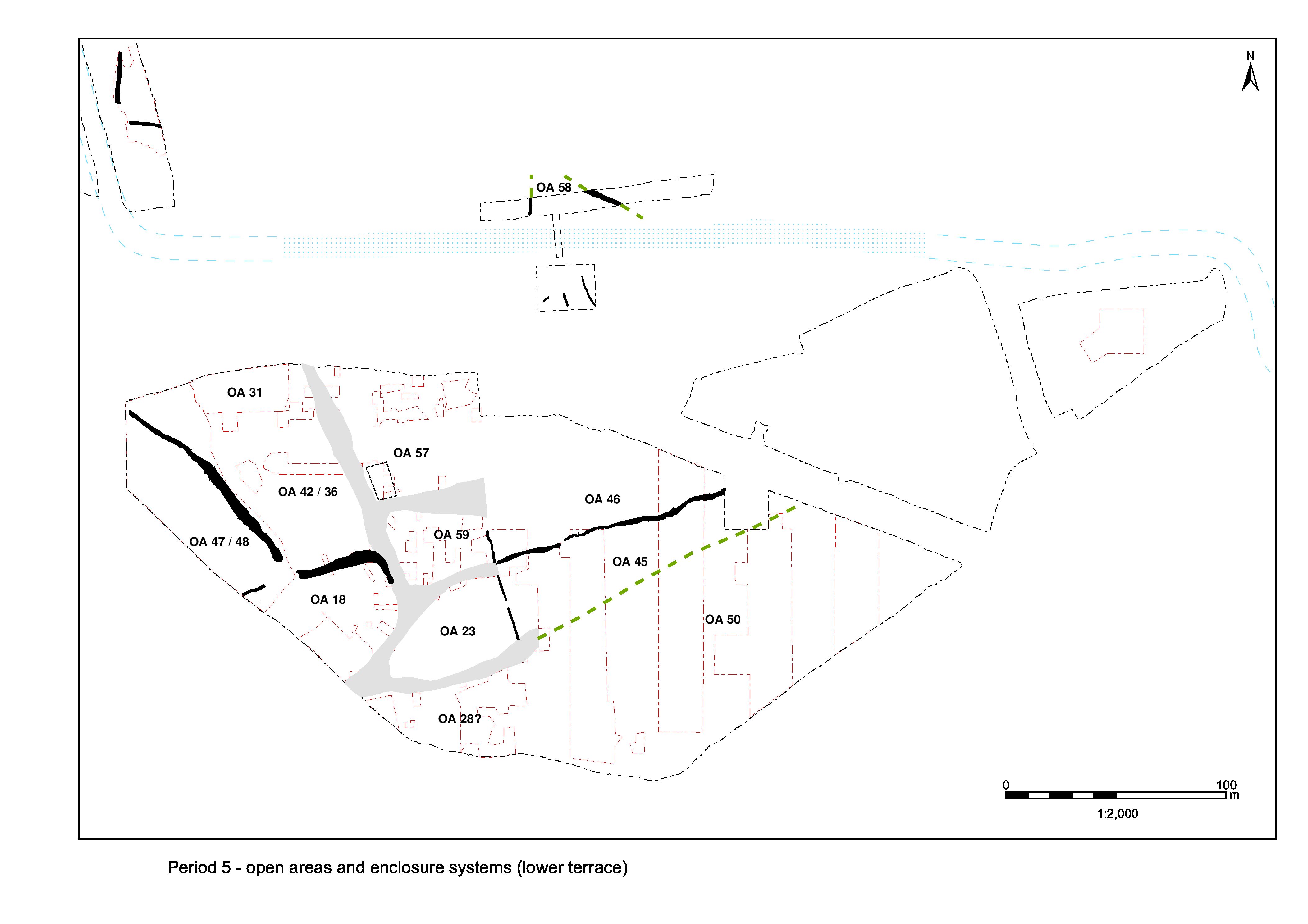
As there is no tangible evidence for the perpetuation of any subdivisions (i.e. into OAs 33-36) of that part of the Northern Zone east of Road 1, there seems little point in attempting to impose any. It is likely that the whole expanse bounded by Road 1, Road/track 5 and the watercourse is to all intents and purposes a single entity in the Late Roman period. This entity is now termed Open Area 57 (Figure 194).
This part of the settlement perhaps loses its subdivision on the demise of Building 54. Building 58 is subsequently constructed in a slightly more central position and could be the principal building occupying this enlarged entity. Parallel ditches to its east (rear?) could constitute some subdivision, even an unsurfaced trackway, running across OA57. It is worth noting that this possible boundary line is on a roughly similar line to those of the 'frontage' walls of both OAs 23 and 59. Further minor ditches/gullies occur to the east, alongside the watercourse, though given the intervening distance they may not be associated.
In the south-west corner of OA57, close to the junction of Roads 1 and 5, in situ charred stakes set within the wall foundations of Building 54 (Period 4) demonstrates that the building is destroyed by fire. The burnt daub packing which had been used in the construction of the wall foundations is consequently even more burnt on its internal edges and silty sand layer 7742 (Group 856 Period 4), which lies within the building, is also burnt in places.
However, no particularly expansive deposits of in situ destruction debris overlie the building, indicating that the fire-damaged remains are cleared down to ground level Though originally seen as building collapse, the deposits of burnt daub found overlying the wall foundations, within the building and in the tops of adjacent ditches 7645 and 7668 are, in fact, predominantly related to disturbance of the burnt daub-packed foundations rather than constituting the remains of standing walls destroyed by fire. Layers 7465, 7471, 7495, 7596, 7624, 7656, 7665, 7690, 7712, 7730 (Group 865) largely comprise silts containing varying proportions of daub debris, though silty sand layer 7730 and overlying pebble spread 7712 may represent a surface related to the late occupation of the building. Debris layer 7471/7656/7665 is overlain by final Period 5 Road 1 surface 7464.
A subsequent build up of silt deposits 7469, 7470, 7499, 7506, 7567 and 7627 (Group 873) over the remains of Building 54 contains 4th century pottery (and one such deposit dates to the late 4th+ century). These deposits incorporate much burnt daub derived from disturbance of the foundation fills.
Narrow slots or gullies 25040 (segs 7074, 7081), 25216 (seg. 7069), 7099 and 7392 (Group 878) define three sides of a rectilinear structure located toward the west end of OA57 and north of the site of former Building 54. Post-holes and other short lengths of slot (7066, 7083, 7087, 7089, 7091, 7093, 7095, 7269, 7244 Group 879) are associated with the major slots. This configuration is interpreted as the foundations of a building - Building 58 - 14m long and at least 14m wide. However, it remains possible that these features define nothing more sophisticated than a simple fenced enclosure such as an animal pen.
The slots are slightly irregular, varying between 0.2-0.4m width and 0.12-0.2m depth along their length. It is probable that part of 25216 was not recognised where it ran across Period 4 pits 7284 and 7294 (Group 869) and that the western side of the rectilinear structure is as extensive as the eastern. The existence of a southern side to the structure is unproven but it is considered likely to have been the case. Major post-hole 7066 is located on the corner of slot 25040, while smaller post-hole 7244 lies within the apparent terminal of slot 25216.
Within the interior of the building, a short line of stakeholes runs along the edge of slot segment 7074. Similar stake-holes elsewhere around the interior may have passed unnoticed at the time of excavation. Additional short lengths of slot (segs 7083, 7099 and 7169) overlie parts of the major slots (segs 7074 and 7081) and may represent wall repairs. It is noteworthy that these occur where wall lines cross underlying pits. Furthermore, the pre-excavation plan hints at a possible southwards continuation of slot 25216 after a gap of 2.0m, perhaps denoting a doorway on this west side of the structure. No other internal structural features or floors are identified. It is suggested that this building faces onto Road 1, parallel with and set back from it by a distance of approximately 15m.
The fills of slot segment 7081 and its repairs, 7083 and 7099, yield the bulk of the finds of pottery, tile and animal bone. As these features run over mid-Roman pits it is possible that some of this material may be derived from the underlying features and that the rather lower incidence of bulk finds in slots 7069 and 7074 would be more typical. Slot segment 7069 includes a 4th century AD coin (SF1116) and other dating evidence generally supports a 4th century date for Building 58.
A putative building lies alongside Road 5, on the southern edge of OA 57. Building 60 comprises a series of large, clay-filled, post-holes or post-pads (7001 Group 880), which were recorded on the pre-excavation plan but not subsequently excavated. Four such features are definitely identified; circular deposits of clean clay some 0.4m in diameter. A further three post-holes, albeit lacking distinctive clay fills, appear to conform to the rectilinear patterning exhibited. These features define parts of the north, west and possibly east sides of a rectangular structure that would measure at least 8.75m by 8m. No post-holes marking its southern limit have been recognised so, although this likely building follows the prevailing NNW-SSE alignment, its precise relationship to Road 5 cannot be determined.
Although the component post-holes were not excavated, they are clearly the latest features in an area of stratified deposits. The alignment on the adjacent road, overall scale of construction and use of clay packing suggests a Roman date and so this building is tentatively assigned to the Late Roman period. As these features were not excavated, there is no dating evidence from them.
Although already described as Period 5 features overlying Road 5, thus potentially signalling its disuse), slot 7439 (Group 876) and shallow pit 7435 (Group 883) could perhaps form part of the southern extent of Building 60.
Some 18m to the east of Building 58, ditch 25111 (seg. 7085 Group 875) runs on a NNW-SSE alignment. Approximately 0.8m wide and up to 0.5m deep, it runs roughly parallel to Building 58 for a distance of 14.5m, possibly terminating at a point level with the south end of the building. To some extent, the large finds assemblage recovered from its fills merely reflects the extensive excavation of the feature. However, it still appears exceptional for so slight a cut. Along with large quantities of pottery and tile, it contains 9kg of slag and a number of lava quern fragments. Distinct concentrations of material along the ditch were noted during its excavation and it seems likely that this quantity of material reflects deliberate dumping into the ditch rather than gradual accumulation. A later 4th century date for infilling is apparent.
Although not precisely parallel, its similar proportions suggest that 25111 is contemporary with gully/ditch 25249 (Group 874). For most of its recorded length (seg. 7102) this feature is 0.6m wide and a maximum of 0.3m deep and runs on a roughly NNW-SSE alignment for a distance of over 19m, some 8m to the east. A shallow rounded terminal marks its south end but, after a gap of 0.5m, the gully line resumes (as seg. 7058) and continues beyond the excavated area. Pottery from segment 7102 is late 3rd to mid-4th century AD in date.
Additional gullies (25185, 25186, 12301 Group 971), broadly parallel with ditches 25111 and 25249, are located c. 50m further east, close to the south side of the river channel in Excavation Area R. Narrow gully 25185 runs on a NNW-SSE alignment but neither end of this 0.4m wide and 0.3m deep feature was located. It may well extend as far as, and even drain in to, the river channel/marsh.
Gully 25186 is 6m long and runs parallel to gully 25185, 10m to the west. It is a maximum of 0.7m wide and 0.35m deep.
12301 is an unexcavated length of gully. With a similar 0.6m width and NNE-SSW alignment, it may be associated with gully 25186, running at right-angles to it. The dating for these features is late 2nd century but this may well reflect residual material in a peripheral location, and phasing as Late Roman is preferred.
Other than Buildings 58 and 60, activity in the western part of OA57 (Excavation Area G) is confined to pitting. Some Late Roman pits (7188 Group 877) definitely pre-date Building 58, while others (7237, 7259 Group 881) may do. Pits 7159, 7062 and 7302 (Group 883) are located around Building 58. A further group of pits (7394, 7396 Group 884) are not located in plan. All tend to be moderately sized; between 1.2-1.8m wide and 0.3-0.5m deep. In addition, they are irregular to sub-square in shape. The pits have few finds compared to earlier Roman pits (or late pits elsewhere). Thus, few are closely dated, but stratigraphically none can be earlier than mid-Roman.
Circular pit 7114 (Group 885) is 2m in diameter and located directly alongside the north-west corner of Building 58. It may truncate its remains, although this was not definitively proven by excavation. The large assemblage of pottery is of late 3rd to early/mid-4th century AD date. The absence of later 4th century material is curious and it must remain possible that the pit actually pre-dates Building 58.
No Late Roman pits are present further north-east where investigated alongside the watercourse in the southern part of Excavation Area R.
Toward the northernmost edge of development Area A2, still within OA57, pit 6383 (Group 843) is outside Excavation Area G, but was investigated in isolation during the topsoil strip because of the discovery of a coin hoard within it. The small 1m by 0.84m oval pit is only 0.13m deep. The seventy-three coins are mostly barbarous radiates and of probable late 3rd century date. The hoard was probably deposited in a bag and the feature backfilled with soil containing incidental rubbish. A capping of tile fragments was laid in the top of the cut, suggesting recovery was intended. Its positioning alongside Road/track 5 may be significant.
Internet Archaeology is an open access journal based in the Department of Archaeology, University of York. Except where otherwise noted, content from this work may be used under the terms of the Creative Commons Attribution 3.0 (CC BY) Unported licence, which permits unrestricted use, distribution, and reproduction in any medium, provided that attribution to the author(s), the title of the work, the Internet Archaeology journal and the relevant URL/DOI are given.
Terms and Conditions | Legal Statements | Privacy Policy | Cookies Policy | Citing Internet Archaeology
Internet Archaeology content is preserved for the long term with the Archaeology Data Service (ROR). Help sustain and support open access publication by donating to our Open Access Archaeology Fund.