Figure 1: The Netherlands in the Roman period, with military forts along the River Rhine and the Dutch River Area.
The Roman Dutch River Area consisted of a dynamic landscape with a continuous alternation of land and water. The levees that flanked the rivers and the streamridges located away from active rivers were high and relatively dry places, but were still prone to flooding. The low-lying flood basins were regularly flooded, mostly during the winter. Although all elements in the river landscape could be flooded, making this landscape a comparatively dangerous place to live, it was relatively densely populated, especially in the 2nd century AD. That was because the Dutch River Area was fertile: the soil type was already fertile and with every flood new nutrients were added. The inhabitants of this dynamic river area were farmers. They lived in small rural settlements, each consisting of one or several farmyards. The agrarian economy was based on mixed farming. Based on the modern agrarian function of the Dutch River Area, archaeologists in the late 20th century concluded that stockbreeding was the main part of farming (Willems 1986, 377-86; van Es 1994, 56; Roymans 1996, 51). Detailed research on the structure of agrarian settlements, as well as environmental studies, have demonstrated that arable farming and stockbreeding were both important in the Roman period (Kooistra 1996; Groot 2008a; Vos 2009; Heeren 2009).
This article will discuss how farmers of an average rural community in the Dutch River Area in the Roman period used the surrounding river landscape (see Fig. 16), with its different landscape elements, in the period AD 50-150. The following questions will be addressed:
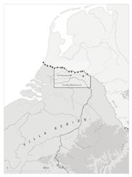
The possibilities for arable farming and animal husbandry were influenced to a large extent by the landscape. However, there are more factors that may have influenced the agrarian economy and agrarian land use. From the middle of the 1st century AD, the Dutch River Area became part of the Roman Empire (Fig. 1). The impact of this was enormous and social structures changed fundamentally. Changes in land ownership and social structure can have a major effect on land use, especially when most of the land is owned by a few. Unfortunately, very little is known about land ownership and land claims in the Dutch River Area, making it impossible to assess the effect on land use. Another potential factor is the supposed lack of adult men as a result of military recruitment among the Batavians; this could have resulted in a shortage of agrarian labourers. Incidentally, the end of military recruitment as a form of taxation around AD 100 may have been responsible for the rise in population in the 2nd century (Bloemers 1978, 103-13; Willems 1986, 397, 416-17). An increase in population is reflected in a much higher settlement density in the area around Tiel-Passewaaij in the Middle Roman period (Vossen 2007, 37, 39-40, fig. 6), which would certainly have put extra pressure on the land. Although these factors may have played a role, we believe that they were of marginal impact when compared with that of the landscape itself. A factor that potentially had more impact on land use is the incorporation of the agrarian economy in a market system and in an empire that imposed taxation. Whereas before the Roman period, farmers only produced to satisfy their own needs, in the Roman period the farmers of the Dutch River Area produced for the Roman market and the tax collectors as well as for themselves (Kooistra 1996; Groot 2008a; 2008b; Groot et al. in press; Vos 2009, 251-60). The agrarian surplus may have been sold to the large number of soldiers stationed in the military camps along the Rhine, but could also have been collected as taxation.
Figure 1: The Netherlands in the Roman period, with military forts along the River Rhine and the Dutch River Area.
As a case study, we will focus on one community in Tiel-Passewaaij for which settlements and a cemetery were excavated, and for which the surrounding landscape is well known (Vossen 2007; Vossen in prep.). The settlement structure and development have been studied in detail (Heeren 2006; Heeren 2009), and data are also available on both botanical and animal remains (Groot 2008a; Fokma 2005; Kooistra and Heeren 2007). While one of the strong points of the Tiel-Passewaaij excavations is their multi-phased chronology, covering the entire Roman period, it was impossible to incorporate all the information on changes in settlement layout and structures in one map. For that reason, this article focuses on a time period within the occupation of the sites: AD 50-150. Although changes still occurred during this more limited time period, they are easier to describe. Changes in the agrarian economy and settlement structure will be discussed in the text where they are relevant to land use. Another reason for choosing this period is that this is the moment when the agrarian economy changed from a subsistence system (with some exchange) to a system of surplus production. More agrarian settlements from this period have been excavated; these provide a comparable picture of the agrarian economy. Therefore, we assume that the rural community of Roman Tiel-Passewaaij can function as a general model for the agrarian economy and land use in the Dutch River Area.
While we are aware of the symbolic aspects of landscape, this article will study the landscape as a focus of agrarian activities and a source of natural materials. Our approach is an economic and environmental one, where the landscape is perceived from an ecological and agrarian point of view. Whereas our earlier research focused on surplus production (Kooistra 1996; Groot 2008b; Groot et al. in press), this article will concentrate on the setting where this surplus was produced.
Several factors played a role in determining what agrarian activities took place where: soil type, water level, need for manure and labour, and possibilities for transport. Soil type and water level put limitations on cereals and other crops that could be grown, and determined the natural plant sources. Variation in the landscape had an impact on how the land surrounding a settlement was organised. Those agrarian activities that required the most manure and regular attention were situated closest to the settlement. Vegetable gardens, with a high requirement for manure and almost daily attention, were therefore located in the settlement. Arable fields were situated around the settlement. Pasture was located somewhat further away, and meadows, which were only mown once a year, were furthest from the settlement. Besides cultivated crops and livestock, we must also consider the role of natural resources in an agrarian economy (for instance, construction materials such as reed and wood, but also hunting, fishing and the collecting of wild plants, fruits and nuts).
Section 2 provides essential background information on the geology of the Dutch River Area, the archaeology of the area in the Roman period, the settlements and their chronology, archaeobotanical and zooarchaeological research. The results of this study will be presented through an interactive map, which provides information on the various agrarian activities and locations in the landscape. The map contains (references to) the various landscape elements, habitation elements, the different species of livestock and crop that were cultivated, and natural sources of food or other things. The whole of section 3 is represented in the map. The article ends with a short discussion on agrarian land use. A model for land use in the Roman Dutch River Area is presented, based on our results.
© Internet Archaeology/Author(s)
URL: http://intarch.ac.uk/journal/issue27/5/1.html
Last updated: Tue Nov 10 2009