Figure 2: A modern river unchanged by dikes and other human interference: River Omolon in Russia. Photo J.A. de Raad. 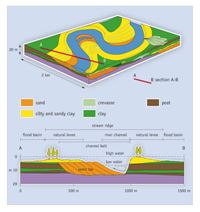
Figure 3: Schematic overview of the riverine landscape (after Berendsen and Stouthamer 2001, fig. 3.4).
Figure 2: A modern river unchanged by dikes and other human interference: River Omolon in Russia. Photo J.A. de Raad.
Figure 3: Schematic overview of the riverine landscape (after Berendsen and Stouthamer 2001, fig. 3.4).
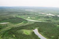
The Rivers Rhine and Meuse flow through the centre of the Netherlands, from east to west. Although these are old rivers, their current position in the Netherlands dates to the end of the last Ice Age (Late Weichselien). The discharge of water was irregular at that time owing to the cold tundra climate, while the supply of sediment was large. This resulted in braiding river systems, with a breadth of several kilometres. The warmer climate of the Holocene caused an increase in vegetation, and the braided rivers changed to meandering incising streams, due to the drop in height from the east to the west of the Netherlands and the soft soil of sand, gravel and clay. The rivers broke through their banks during periods of high water, when they flooded the surrounding river plains. In the fast-flowing water close to the river, only coarse sand and gravel settled down. The further the water flowed from the river, the slower the current, which was when smaller clay particles subsided. In this way, levees arose along the rivers, and flood basins further from the rivers (Figs. 2 and 3). The meandering rivers constantly changed their courses and thus caused a dynamic landscape. Although the levees kept rivers to their courses to a certain degree, they were flooded during extreme amounts of water discharge. These breakthroughs are called crevasses. Because of the strong forces involved, coarse sand was set down close to the river, causing extra relief in the landscape.
In actively meandering river systems, such as those of the Rivers Rhine and Meuse until c. 1000 years ago, primary channels regularly fall out of use, and secondary channels take over their role. When a river is no longer active the river bed silts up, and after some time only a residual channel remains. When a river is no longer active the flood plains are no longer flooded and the clay sediment settles to groundwater level (and becomes lower). The former river beds and river banks consist of much courser sediment that does not settle, so that eventually the old river bed and its levees will become a higher ridge (streamridge) in the landscape. The ribbon-like depression in the old river bed betrays the course of the residual channel, even after a long period of time has passed.
The process of meandering rivers with levees, flood basins and old primary channels transforming into streamridges, existed for many thousands of years. This led to the Dutch River Area: an area of at least 20km wide, consisting of a maze of water-carrying primary channels with levees, streamridges, residual channels and flood basins (Berendsen and Stouthamer 2001). This landscape, which is unique in Europe, and where land and water alternated, was populated by man from the start. That is not surprising, because although flooding could be a problem, the streamridges and levees were also fertile and suitable for habitation and farming. In the Middle Roman period, between AD 70 and 200, the Dutch River Area was relatively densely populated. Indications for a rising water table in the Roman period have been found at several places in the deltas of the Meuse and Rhine. In the western Netherlands, this led to renewed peat accumulation at the end of the Roman period. In the northern part of the River Area, this process can be recognised by the abandonment of Early and Middle Roman settlements on the older and relatively low-lying streamridges (Kooistra 1996, 54; Hessing and Steenbeek 1992, 22). There are two possible reasons why the Dutch River Area became wetter. The disappearance of the woodlands along the Rivers Meuse and Rhine may have caused flooding in the Dutch River Area, by lowering the volume of water that could be carried off during periods of high water. More rainwater would thus be left in the area. Local factors such as stagnation in drainage owing to silting up of rivers and residual channels could also have led to a region becoming wetter. The water table may indeed have risen significantly as a result, and this would further hinder the discharge of water.
The key site of this article, Tiel-Passewaaij, is located south of the town of Tiel, on a streamridge of the Rhine delta (Fig. 4), in the centre of the Dutch River Area.
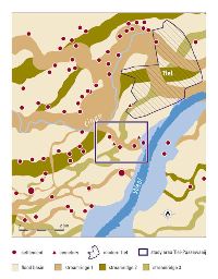
Figure 4: The area around Tiel-Passewaaij, showing the different streamridges and the micro-region of Tiel-Passewaaij. Streamridge 1 became inactive during the Roman period. Streamridge 2 was inactive from the Iron Age, and streamridge 3 from the Bronze Age. The older streamridges remained as a slightly higher section in the surrounding flood basin.
© Internet Archaeology/Author(s)
URL: http://intarch.ac.uk/journal/issue27/5/2.1.html
Last updated: Tue Nov 10 2009