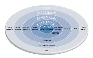
Figure 61: Model of the main land use activities of the inhabitants of an average rural settlement in the Roman period in the Dutch River Area. Illustration Bert Brouwenstijn, ACVU.
We have attempted to reconstruct land use for a typical agrarian community (Tiel-Passewaaij) in the Roman Dutch River Area. Various sources of information were used. The geological situation provided the basis for a landscape reconstruction. Results from large-scale excavations show the location of settlements, a cemetery and enclosure ditches dug in the beginning of the 2nd century AD. Botanical and zooarchaeological studies provided information on the crops that were grown, plants that were collected from the wild and the animals that were raised and hunted. In some cases, they also allow us to reconstruct what activities took place where. Using different sources has resulted in a more complete picture of land use and the agrarian economy in Tiel-Passewaaij.
Tiel-Passewaaij was situated in a dynamic river landscape, and this had a large influence on agrarian land use. Small differences in height determined where people could live, farm and graze their livestock. The higher, sandier streamridges hardly ever flooded and were suitable for habitation and growing crops. The flood basins flooded in winter and had clay soils, which made them unsuitable for growing crops. They provided very good grassland, however, offering plentiful pasture and meadows. Because of minor differences in height within the flood basin caused by an older streamridge, the flood basin just below the cemetery was relatively high. By using the different parts of the landscape for different activities, optimal use was made of the soil and natural resources since the Bronze Age.
In the Roman period, population growth and increasing market orientation made it even more important that the landscape was used in the most efficient way possible. With a high settlement density and limits on the available land, especially land suitable for arable farming, pressure on the land increased. This caused intensification of the agrarian economy. The basic use of the landscape elements did not change, with arable farming on the streamridges and livestock in the flood basins. However, the integration of arable and pastoral farming became stronger.
Intensification of arable farming is indicated by a change in exploitation of cattle, with more emphasis on manure and labour. More arable land in use also means that more cattle were needed for ploughing and transport. Grazing livestock on stubble and fallow fields – a direct way of applying manure to the land – is another indication for a more intensive use of land. A second advantage was that part of the flood basin could be reserved as hayland. The large granaries that are found in the 2nd century could be arguments for intensified arable or livestock farming, depending on whether they held cereals or fodder.
In the 2nd century, cattle and horses were produced as a surplus for the Roman market. When the number of animals increased, the natural landscape could no longer support them during the winter, and extra feeding was necessary. The system of large ditches constructed in the early 2nd century was located on a higher section of the flood basin, the remains of an older streamridge. The soils here were sandier and had better drainage. The enclosures can be a sign of intensification of arable or livestock farming. They may represent an extension of the arable land in a period that surplus production started to be necessary. On the other hand, enclosed fields could also have held livestock or be used as hayland. Although the land was certainly used in a more intensive way, land use did not change in essence.
Figure 61 shows a model of land use in the Dutch River Area, based on Tiel-Passewaaij. The farmhouse is the centre of daily life. Cattle, and possibly also other animals, were stabled in the byre section of the farmhouse. Stabling animals overnight was the most efficient way of collecting manure. In the settlement outside the farmhouse, agrarian activities such as threshing (with animals or by hand) and tending to animals took place. Food crops and fodder was stored in granaries, and from the 2nd century horses were stabled in separate buildings. Pigs and chickens were kept in the settlement. Vegetable gardens were located within the settlement, where the crops could receive attention (manure, weeding, harvesting) when necessary. The settlements were situated on the southern edge of the streamridge. Arable fields were located on the streamridge north of the settlements, and in the 2nd century perhaps also in the enclosures on the older streamridge in the flood basin. Cereals and probably flax – both summer crops – were grown here. A two-course rotation system was probably used, leaving half the land fallow. A residual channel flowed in the centre of the streamridge, but silted up in the late 1st century AD. A marshy depression remained visible. The residual channel's function changed from a supply of drinking water to a provision of wild plants as fodder. The flood basins were located directly to the south of the settlements, and north of the streamridge. Vegetation consisted mainly of grassland and marshes, with some trees (willow and alder). Wood for the construction of farmhouses and fuel was probably collected from the flood basin. The flood basins offered fertile grazing for livestock and hay. While parts of the flood basin were flooded in winter, it is likely that some dry land remained, offering refuge for livestock. An older streamridge transects the flood basin and was slightly higher than the surrounding land. The southern levee of the River Linge was the most likely place for any remnants of woodland. This levee was relatively sparsely populated, and within reach for the inhabitants of Tiel-Passewaaij. While hunting was relatively unimportant, the wild mammals that are found among the animal bones could have lived on the levee or in the flood basins. Wild fruits and hazelnuts could be collected on the levee or on the streamridge.
Figure 61: Model of the main land use activities of the inhabitants of an average rural settlement in the Roman period in the Dutch River Area. Illustration Bert Brouwenstijn, ACVU.
The agrarian economy of the Dutch River Area was traditionally seen to be largely reliant on pastoral farming (Willems 1986, 377-86; van Es 1994, 56; Roymans 1996, 51). Cereals were only produced for domestic consumption. Any surplus consisted of animals. Kooistra argued that a surplus of cereals could be produced in the 1st century, but not in the 2nd century because of the population increase (1996, 71-73). She believed that the emphasis of the agrarian economy was on arable farming. Recent research suggests that a surplus of cereals as well as animals could be produced (Groot et al. in press). The amount and type of surplus varied with the time period and between settlements. For Tiel-Passewaaij, there seemed to be a discrepancy between the large granaries and the available arable land. An extension of arable fields on the old streamridge in the flood basin partly explains this. Nevertheless, it is still likely that part of the granaries was used for storage of hay or other fodder. Fodder was not needed earlier, when livestock density was lower. The intensification of both arable and pastoral farming resulted in a much closer integration of the two sides of the agrarian economy (Fig. 62). Although a surplus of crops and animals was produced, this happened at a relatively small scale. The surplus of cereals cannot be compared to the industrial production of the villa landscape, but the Dutch River Area should not be disregarded as a supplier of goods to the Roman army and urban market. Increased production was made possible by an efficient and more intensive way of using the surrounding landscape elements.
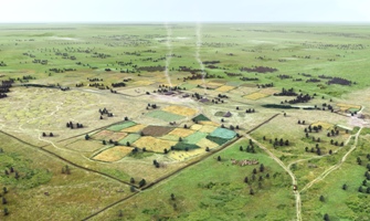
Figure 62: A reconstruction of Tiel-Passewaaij in mid-July, AD 150, looking from the south-west. Illustration Mikko Kriek, ACVU-HBS.
© Internet Archaeology/Author(s)
URL: http://intarch.ac.uk/journal/issue27/5/4.html
Last updated: Tue Nov 10 2009