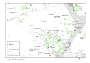
Period 3B in OA18 denotes a radical change in the character and use of the enclosure. The roundhouses and associated pits that previously occupy the enclosure are cleared and the gravel surface abandoned and a concerted raising of the enclosure interior is carried out prior to its reoccupation (Figure 83).
This section describes the transitional, land-raising, stage between the Period 3A and 3B occupation of the enclosure. Subsequent occupation is described in the western sub-plot and eastern sub-plot sections.

A sequence of substantial silt layers is deposited across the interior of OA18. Much of this rubbish-rich material seems to be domestic waste, presumably brought in from elsewhere in the settlement. The cumulative effect of this widespread dumping is a marked raising in contemporary ground level - perhaps as much as 0.3m.
It seems likely that OA18 is given over to waste dumping throughout Period 3B. The identification of the base of a probable midden 5721-2 (Group 607) suggests that the area may even become something of a rubbish tip for a time and that a significant amount of the artefact-rich dump material may derive from the subsequent levelling of this midden, and possibly of others. This identified midden was initially discerned as a 10m-wide, roughly circular, gully 5722 (Group 607) cutting the exposed surface of the dump deposits. Attempts to excavate this 'feature' revealed its circularity to be the product of the truncation of what had originally been a sequence of heaped silt deposits. This has subsequently been reinterpreted as the basal remains of a midden, around which the dump deposits accumulate. As discussed above, it is possible that at least some of the surrounding dump deposits are derived from the levelling of this midden and it is noteworthy that the pottery from this feature is similar to that of the dumps too.
Eventually c. 0.3m of silts overlie the Period 2B gravel surface (Group 102) and extend across almost the whole of Open Area 18, running up to/onto Roads 1 and 2. The silts thin out towards the northern edge of the open area. During its controlled machine removal, variations in soil type and artefact density were noted and, to some extent, the assigning of so many context numbers to this dump episode is a reflection of this. It is likely that within this broad grouping of silt layers there is contamination, residuality and intrusion - derived from features both above and below - hence the wide collective date range (mid-1st to mid-3rd century). Large and varied assemblages derive from these deposits, suggesting that they contain a significant component of domestic rubbish. The main episode of midden/dump accumulation is described by Group 600 (5709, 5764, 5765, 5775, 5776, 5877, 5972, 5990, 10071, 13037, 13038-13042, 13053, 13147, 13151, 13221, 13223, 13261, 13354, 13355, 13360, 13406, 13418, 13445, 13468, 13491, 13498, 13556, 13557, 13568, 13576, 13687, 13823, 13851, 18205, 18355, 18500, 18501, 18502, 18503, 18504, 18507).
These interleave with more gravelly roadwash type deposits (5496, 5907, 5987, 13199, 13213 Group 601). Another area of silt dumping (5693, Group 609) was investigated within an excavation trench alongside the Roads 1, 2 and 4 junction. Soil micromorphological analysis of sandy roadwash 5972 (Group 600) indicates conditions of high water-table and high phosphate content; that of 5951 (Group 606) and 5987 (Group 601) middening, dung and waste ground.
Wheel ruts are noted both within (Group 599) and on the surface of (Group 602) the Group 600 midden dumps. These wheel ruts define a narrow route only 2.0-2.5m wide but at least 23m long, curving in a broad arc roughly north-west to south-east. It is likely that further such ruts were not recognised within the silt dump layers; those recorded perhaps being the most prominent and often penetrating the silt to leave linear 'scars' upon the underlying gravel surface. It is conjectured that this short-lived track denotes the cartage of dump material into or across the OA18 interior.
Internet Archaeology is an open access journal based in the Department of Archaeology, University of York. Except where otherwise noted, content from this work may be used under the terms of the Creative Commons Attribution 3.0 (CC BY) Unported licence, which permits unrestricted use, distribution, and reproduction in any medium, provided that attribution to the author(s), the title of the work, the Internet Archaeology journal and the relevant URL/DOI are given.
Terms and Conditions | Legal Statements | Privacy Policy | Cookies Policy | Citing Internet Archaeology
Internet Archaeology content is preserved for the long term with the Archaeology Data Service. Help sustain and support open access publication by donating to our Open Access Archaeology Fund.